This is the online version of the Zoning Code of Centerville City, Utah. The Centerville Zoning Code is codified as Title 12 of the Centerville Municipal Code, and has been placed into its own online book for organizational purposes and ease of use for citizens, developers, city staff and others. The Centerville Zoning Code may be referred to herein as "CZC" or "Title 12" of the Centerville Municipal Code. The Centerville Municipal Code may be referred to herein as "CMC".
The Centerville Zoning Code is arranged by subject matter and divided into various chapters and sections. The Centerville Zoning Code follows the codification structure set forth in the Centerville Municipal Code which uses a decimal numbering system identifying the title, chapter, and section of various portions of the code (e.g., 1.01.010). This numbering system is further described as follows:
- The first number in the sequence (1.01.010) designates the title level
- The second number in the sequence (1.01.010) designates the chapter level
- The third number in the sequence (1.01.010) designates the section level
Vacant titles, chapters or sections may be designed for future use and may be marked "Reserved" to ease internal expansion.
The Centerville Zoning Code is amended and supplemented from time to time with amendments, additions and deletions adopted by ordinance of the Centerville City Council. The specific provisions of this online code have been compiled and codified to comprise the Centerville Zoning Code as adapted from the official ordinances adopted by the City Council. In the event of discrepancies between the online Centerville Zoning Code and the official hard copy of the ordinances adopted by the City Council, the hard copy enactment governs.
The legislative history of each particular section of the Centerville Zoning Code is provided at the end of each section in italicized text and is used to keep track of and identify the specific ordinances and enabling legislation. The legislative history refers to each ordinance adopted by the City Council which affects that particular section and indicates whether the section has been enacted, amended, renumbered, recodified or corrected. A link to the actual ordinance is also provided when available. Legislative history is available for any Zoning Code amendments enacted after July 1, 2016.
NOTICE: THIS ONLINE CENTERVILLE ZONING CODE MAY NOT REFLECT ALL OR THE MOST CURRENT VERSION OF LEGISLATION ADOPTED BY THE CENTERVILLE CITY COUNCIL. IT IS THE CITY'S POLICY AND PRACTICE TO UPDATE THIS ONLINE ZONING CODE AS SOON AS POSSIBLE AFTER LEGISLATION HAS BEEN ADOPTED BY THE CITY COUNCIL, BUT SOME DELAY DOES OCCUR BETWEEN THE TIME OF ADOPTION OF AMENDMENTS AND THE UPDATING OF THIS ONLINE CODE. IN THE EVENT OF CONFLICT BETWEEN THIS ONLINE CODE AND THE OFFICIAL ORDINANCES ADOPTED BY THE CITY COUNCIL, THE ORDINANCES SHALL GOVERN. ALSO, THIS ZONING CODE MAY NOT REFLECT RULES, REGULATIONS, STANDARDS OR SPECIFICATIONS PROMULGATED UNDER AUTHORITY OF THIS CODE OR STATE LAW. PLEASE CONTACT JENNIFER ROBISON, CITY RECORDER, FOR THE STATUS OF ANY CODE SECTION OR FOR OTHER APPLICABLE RULES, REGULATIONS, STANDARDS OR SPECIFICATIONS AT 801.295.3477 OR JENNIFER.ROBISON@CENTERVILLEUTAH.GOV.
12.10.020 Authority
12.10.030 Purpose
12.10.040 Scope
12.10.050 Definitions
12.10.060 Applicable Provisions Not In This Title
12.10.070 Organization Of Title
12.10.080 Licenses And Permits To Conform
12.10.090 Construction And Use To Conform To Plans
12.10.100 Certificate Of Occupancy
12.10.110 Conflicting Provisions
12.10.120 Omission Not A Waiver
12.10.130 Severability Of Parts Of Title
This Title shall be known as the Centerville Zoning Code and may be so cited and pleaded. This Title may also be referred to as CZC or "this Title."
This Title is adopted pursuant to the Utah Land Use Development and Management Act, as set forth in Utah Code § 10-20-101, et seq., the general welfare power delegated to municipalities as set forth in Utah Code § 10-8-84, and the police power authority of local government established by Utah common law. This Title constitutes the land use ordinance authorized by the Utah Municipal Land Use Development and Management Act.
This Title is designed and enacted to:
- Protect public health, safety, and welfare;
- Promote the prosperity, peace and good order, comfort, convenience, and aesthetics of the City and its present and future inhabitants and businesses;
- Protect the City tax base;
- Promote economy in governmental expenditures;
- Protect urban and non-urban development; and
- Preserve and protect property value.
This Title shall apply to all property within the corporate limits of the City except property expressly exempted by the provisions of this Title or other lawful exemption.
Certain words and phrases in this Chapter are defined in CZC 12.12 (Definitions).
Centerville Municipal Code provisions not found in this Title which are applicable to the use and development of land include, but are not limited to, the following:
- CMC 3.7 (Constitutional Takings Review)
- CMC 6.5 (Sexually Oriented Businesses)
- CMC 7.5 (Fire Regulations)
- CMC 9 (Water)
- CMC 10 (Building Regulations)
- CMC 15 (Subdivisions)
- CMC 16 (Stormwater)
- City Standards and Specifications
This Section describes the basic organizational scheme used in this Title and the types of regulations found herein. It is intended to be informational only. Failure to follow the format described in this Section shall not be a basis for invalidating any action taken pursuant to this Title.
- Organizational Structure. This Title consists of numerous chapters organized to address the following:
- General Provisions (CZC 12.10 to CZC 12.19)
- Administration and Enforcement (CZC 12.20 to CZC 12.29)
- Base Zones (CZC 12.30 to CZC 12.39)
- Special Purpose and Overlay Zones (CZC 12.40 to CZC 12.49)
- Regulations of General Applicability (CZC 12.50 to 12.59)
- Regulations for Specific Uses (CZC 12.60 to 12.69)
- General Provisions (CZC 12.10 to CZC 12.19)
- General Provisions. The General Provisions of CZC 12.10 to CZC 12.19 establish how this Title is applied, describe how planning documents relate to this Title, and provide rules and definitions for interpreting and applying the provisions of this Title.
- Administration and Enforcement. Administration and enforcement provisions in CZC 12.20 to CZC 12.29 describe the powers and duties of decision-making bodies and officials, procedures for considering land use applications, and standards for dealing with nonconforming circumstances. Enforcement provisions set forth remedies to correct violations of this Title.
- Types of Zones. This Title establishes three types of zones (also called “zoning districts”): base zones, special purpose zones, and overlay zones.
- The base zone provisions set forth in CZC 12.30 to CZC 12.39 establish regulations and development standards that govern land uses allowed in each base zone. Base zones are grouped into five general categories: agricultural, residential, public facility, commercial, and industrial zones.
- The special purpose zone provisions set forth in CZC 12.40 to CZC 12.49 establish regulations that apply only in limited instances or to special circumstances.
- The overlay zone provisions set forth in CZC 12.40 to CZC 12.49 establish regulations that address specific circumstances in certain geographic areas and which may traverse the boundaries of a number of base zones. Overlay zone regulations apply in addition to base zone regulations.
- The base zone provisions set forth in CZC 12.30 to CZC 12.39 establish regulations and development standards that govern land uses allowed in each base zone. Base zones are grouped into five general categories: agricultural, residential, public facility, commercial, and industrial zones.
- Types of Regulations. This Title includes the following kinds of regulations and development standards.
- Base zone regulations set forth in CZC 12.30 to CZC 12.39 specify land uses allowed as of right or allowed after issuance of a conditional use permit. These regulations may be modified by overlay or special purpose zone regulations, set forth in CZC 12.40 to CZC 12.49, or augmented by regulations for specific uses set forth in CZC 12.60 to CZC 12.69. Base zone and overlay regulations are further augmented by Regulations of General Applicability set forth in CZC 12.50 to 12.59.
- Development standards set forth in CZC 12.30 to CZC 12.39 include fixed dimensional standards and performance standards. Development standards control the height, size, location and other particular aspects of structures and uses on sites intended for development. These standards also prescribe setback and buffering requirements between zones and between potentially incompatible uses. Fixed dimensional standards establish numerical maximum or minimum conditions which govern development on a particular site. Performance standards establish certain standards which must be met, but may allow flexibility as to the method of meeting the standard.
- Base zone regulations set forth in CZC 12.30 to CZC 12.39 specify land uses allowed as of right or allowed after issuance of a conditional use permit. These regulations may be modified by overlay or special purpose zone regulations, set forth in CZC 12.40 to CZC 12.49, or augmented by regulations for specific uses set forth in CZC 12.60 to CZC 12.69. Base zone and overlay regulations are further augmented by Regulations of General Applicability set forth in CZC 12.50 to 12.59.
- Conformance Required. The provisions of this Title shall be construed as the minimum requirements necessary to promote public health, safety, morals, convenience, order, prosperity and welfare of the present and future inhabitants and businesses of the City. Each department, official, and employee of the City vested with the duty or authority to issue permits or licenses shall conform to the provisions of this Title and shall issue no permit or license for a use, building, or purpose where the same would conflict with the provisions of this Title. Any permit or license issued in violation of this Title shall be null and void.
- Permits Required. No building or structure shall be constructed, reconstructed, altered, or moved, nor shall the use or status of land be changed except after the issuance of valid permits which conform to the requirements of this Title, unless no permit is required by this Title or by the Construction Codes adopted by the City.
- Utility Service. No electrical, sewer, telephone, water, or other utility line shall be installed to serve any lot, parcel, building, or structure, or any portion thereof if such installation will violate the provisions of this Title.
- Certificate of Occupancy Required.
- No lot, parcel, or building shall be used or occupied until a certificate of occupancy has been issued pursuant to applicable provisions of the Construction Codes adopted by the City.
- No certificate of occupancy shall be issued unless the building and the lot or parcel on which the building is located conform to applicable provisions of this Title and other Construction Codes and regulations adopted by the City.
- No lot, parcel, or building shall be used or occupied until a certificate of occupancy has been issued pursuant to applicable provisions of the Construction Codes adopted by the City.
- Unlawful to Use or Occupy. It is unlawful to use or occupy, or to permit the use or occupancy of any building or structure, unless a certificate of occupancy has been issued for such building or structure. It is unlawful to use or occupy, or to allow to be used or occupied, any building or structure with a use or occupancy that is different than provided in a certificate of occupancy.
- Failure to Obtain Certificate of Occupancy. Failure to obtain a certificate of occupancy shall be a violation of this Title.
- Nuisance. The use or occupancy of any building, structure, or premises for which a certificate of occupancy has not been issued is hereby declared to be a public nuisance and may be abated as such. It shall also be a public nuisance for any building, structure, or premises to be used or occupied in a manner different than authorized by a certificate of occupancy.
12.11.020 Definitions
12.11.030 General Plan
12.11.040 Master Street Plan And Official Map
12.11.050 Capital Facilities Plan
The purpose of this Chapter is to identify planning documents which provide the policy foundation for this Title and to set forth the basis for preparing and adopting such planning documents.Certain words and phrases in this Chapter are defined in CZC 12.12 (Definitions).
- Purpose. In order to accomplish the purposes set forth in CZC 12.10 (Purpose and Applicability) and to comply with provisions of Utah Code §§ 10-20-401, et seq., regarding general plans, the City has prepared and adopted a comprehensive, long-range general plan for present and future needs of the City and for growth and development of land within the City. Such plan shall be known and referred to as the Centerville General Plan. The City may amend the General Plan as may be necessary and appropriate. The General Plan may provide for:
- Health, general welfare, safety, energy conservation, transportation, prosperity, civic activities, aesthetics, and recreational, educational, and cultural opportunities;
- Reduction of the waste of physical, financial, or human resources that result from either excessive congestion or excessive scattering of population;
- Efficient and economical use, conservation, and production of the supply of food and water, and drainage, sanitary, and other facilities and resources;
- Use of energy conservation and solar and renewable energy resources;
- Protection of urban development;
- Protection and promotion of air quality;
- Protection or promotion of moderate income housing;
- Historic preservation;
- Identification of future uses of land that are likely to require an expansion or significant modification of services or facilities provided by each affected entity; and
- An official map, as provided in Utah Code §§ 72-5-401, et seq.
- Health, general welfare, safety, energy conservation, transportation, prosperity, civic activities, aesthetics, and recreational, educational, and cultural opportunities;
- Scope. The General Plan shall show the City’s recommendations for development of the territory covered by the General Plan, and may consist of text, maps, plats, charts, and descriptive and explanatory matter. The City Council shall determine the comprehensiveness, extent, and format of the General Plan and may include areas located outside City boundaries.
- The General Plan shall include a plan for moderate income housing as required by Utah Code § 10-20-404.
- The General Plan may include, among other things:
- A land use element that:
- Designates the proposed general distribution and location and extent of uses of land for housing, business, industry, agriculture, recreation, education, public buildings and grounds, open space, and other categories of public and private uses of land as appropriate; and
- Includes a statement of the standards of population density and building intensity recommended for the various land use categories covered by the plan;
- Designates the proposed general distribution and location and extent of uses of land for housing, business, industry, agriculture, recreation, education, public buildings and grounds, open space, and other categories of public and private uses of land as appropriate; and
- A transportation and circulation element consisting of the general location and extent of existing and proposed freeways, arterial and collector streets, mass transit, and any other modes of transportation that are appropriate, all correlated with the land use element of the plan;
- An environmental element that addresses:
- The protection, conservation, development, and use of natural resources, including the quality of air, forests, soils, rivers and other waters, wildlife, minerals, and other natural resources; and
- The reclamation of land, flood control, prevention and control of the pollution of streams and other waters, regulation of the use of land on hillsides, stream channels and other environmentally sensitive areas, the prevention, control, and correction of the erosion of soils, protection of watersheds and wetlands, and the mapping of known geologic hazards;
- A public services and facilities element showing general plans for sewage, waste disposal, drainage, local utilities, rights-of-way, easements, and facilities for them, police and fire protection, and other public services;
- A rehabilitation, redevelopment, and conservation element consisting of plans and programs for:
- Historic preservation;
- Elimination of blight; and
- Redevelopment, including housing sites, business and industrial sites, and public building sites;
- Historic preservation;
- An economic element composed of appropriate studies and an economic development plan that may include review of municipal revenue and expenditures, revenue sources, identification of base industry, primary and secondary market areas, employment, and retail sales activity;
- A parks, trails, and open space element that establishes a comprehensive plan for the development of parks and trails, and preservation of open space;
- Recommendations for implementing the General Plan, including the use of zoning and subdivision regulations, capital improvement plans, and other appropriate actions; and
- Any other elements the City considers appropriate.
- A land use element that:
- The General Plan shall include a plan for moderate income housing as required by Utah Code § 10-20-404.
- Legal Status. The General Plan shall be considered only as an advisory guide for growth and development of the land except as may be specifically provided otherwise in this Title.
- Public Uses to Conform. After the City Council has adopted a General Plan or any amendments to the General Plan, no street, park, or other public way, ground, place, or space, no publicly owned building or structure, and no public utility, whether publicly or privately owned, may be constructed or authorized until and unless:
- It conforms to the General Plan, or
- It has been considered by the Planning Commission and, after receiving the advice of the Planning Commission, approved by the City Council as an amendment to the General Plan.
- It conforms to the General Plan, or
- Amendment. The General Plan may be amended as provided in CZC 12.21.070.
- Adoption. A Master Street Plan, adopted as part of the General Plan, shows existing and proposed roads at various right-of-way widths. The Master Street Plan shall serve as the basis for any official map adopted pursuant to Utah Code § 72-5-401, et seq.
- Amendments. Amendments to the Master Street Plan may be made in accordance with the procedures set forth in CZC 12.21.070.
- Effect of Official Map.
- An official map does not:
- Require a landowner to dedicate and construct a street as a condition of development approval, except under circumstances set forth in Subsection (2) below; or
- Require the City to immediately acquire property it has designated for eventual use as a public street.
- Require a landowner to dedicate and construct a street as a condition of development approval, except under circumstances set forth in Subsection (2) below; or
- This Subsection (c) shall not prohibit the City from:
- Requiring a landowner to take into account proposed streets in planning a development proposal;
- Acquiring property through purchase, gift, voluntary dedication, or eminent domain; or
- Requiring the dedication and improvement of a street if the street is found necessary by the City because of a proposed development.
- Requiring a landowner to take into account proposed streets in planning a development proposal;
- The official map of the City shall not be used to unconstitutionally prohibit the development of property designated for eventual use as a public street.
- The adopted official map shall be available for public inspection upon request.
- An official map does not:
- Plan Adoption. The City may adopt a capital facilities plan as provided in Utah Code §§ 11-36a-101, et seq., as amended.
- Capital Facilities Availability. In the event a capital facilities plan is adopted, and capital facilities, as defined in such plan, are unavailable or inadequate to serve a proposed development project subject to the requirements of this Title, the capital facilities plan shall be used as a guide to determine when needed capital facilities may become available.
12.12.020 Scope
12.12.030 Rules Of Interpretation
12.12.040 Definitions
12.12.050 Illustrations
The purpose of this Chapter is to provide rules of interpretation, definitions, and illustrations so that the provisions of this Title may be readily understood and consistently administered.The rules of interpretation, definitions, and illustrations contained in this Chapter shall apply to the entirety of this Title.
- General. All provisions, terms, phrases and expressions contained in this Chapter shall be liberally construed to accomplish the purposes of this Title.
- Conjunctions. Unless the context clearly indicates to the contrary, conjunctions shall be interpreted as follows.
- "And" indicates that all connected items, conditions, provisions or events shall apply.
- "Or" indicates that one or more of the connected items, conditions, provisions or events shall apply.
- "Either . . . or" indicates that the connected items, conditions, provisions or events shall apply singly but not in combination.
- "And/Or" indicates that all or one or more of the connected items, conditions, provisions or events shall apply.
- "And" indicates that all connected items, conditions, provisions or events shall apply.
- Mandatory and Discretionary Terms. The word "shall" is always mandatory. The word “should” means the matter described ought to be accomplished if reasonable and possible under the circumstances. The word "may" is permissive.
- Non-Technical and Technical Words. Words and phrases shall be construed according to the common use and understanding of the language, but technical words and phrases and such others as may have acquired a peculiar and appropriate meaning in law shall be construed and understood according to such meaning.
- Tense, Number, and Gender. Words used in the past or present tense include the future as well as the past or present unless the context clearly indicates the contrary. The singular shall include the plural and the plural shall include the singular as the context and application of this Title may reasonably suggest. Words of one gender shall apply to any person, natural or fictitious, regardless of gender, as the context and application of this Title may reasonably suggest.
- Fractional Numbers. In determining compliance with the numerical requirements of this Title any computation or measurement resulting in a fractional number, except density calculations, shall be rounded to the nearest whole number. Density calculations shall be rounded to the nearest tenth of a number.
- Public Officials, Bodies and Agencies. All public officials, bodies, and agencies to which reference is made are those of Centerville City, Utah, unless otherwise indicated.
- Delegation of Authority. Whenever a provision appears requiring the City Manager, head of a department, or some other officer or employee to do some act or perform some duty, it shall be construed to authorize the City Manager, head of the department, or other officer to designate, delegate, and authorize professional-level subordinates to perform the required act or duty unless the terms of the provision or section, or other applicable law, specify otherwise.
- Computation of Time. The time within which an act is to be done shall be computed by excluding the first day and including the last day. If the last day is a Saturday, Sunday, or holiday, then the last day shall be the next following business day.
- Amendments. Whenever reference is made in this Title to provisions of the Centerville Municipal Code, the Utah Code, any federal law or regulations, or any section or subsection of this Title, such reference shall include any subsequent amendments or renumbering of such referenced provisions.
As used in this Title, the words and phrases defined in this Section shall have the following meanings unless the context clearly indicates a contrary meaning. Words not included herein but defined in the Construction Codes or the Utah Land Use Development and Management Act shall be construed as defined therein.
Accessory Building: See Building, Accessory.
Accessory Apartment: A habitable living area located within a detached single family dwelling which has its own kitchen, living/sleeping areas, and sanitation facilities.
Accessory Use: See Use, Accessory.
Adjacent Landowners: A property owner of record, according to the records of the County Recorder, whose property abuts all or part of property proposed for development.
Agricultural Business: A commercial agricultural activity that requires a business license as provided in CMC 6 (Business Licensing and Regulations) such as a nursery or the boarding or stabling of animals other than those owned and used by household members.
Agricultural Industry: An industry or business involving agricultural products in packaging, treatment, sales, intensive feeding, or storage. Typical uses include animal feed yards, fur farms, commercial milk production, food packaging or processing plants, and commercial poultry or egg production.
Agricultural Processing: Initial processing of agricultural products that is reasonably required to take place in close proximity to the site where they are produced. Typical uses include sawmills and packing houses. Slaughterhouses are specifically excluded from this definition.
Agricultural Sales and Service: An establishment primarily engaged in the sale or rental of farm tools and implements, feed and grain, tack, animal care products, anhydrous ammonia, farm supplies and the like, and including accessory food sales and machinery repair services.
Agriculture: The tiling of soil, raising of crops and animals, horticulture and gardening for personal use or sale, but not including any agricultural business or industry.
Alley: A public thoroughfare for the use of pedestrians and vehicles providing a secondary means of access to the rear of abutting properties.
Animals and Fowl for Recreation and Family Food Production: The keeping of animals on a lot or parcel for exclusive personal, non-commercial, use by persons residing thereon.
Animal Specialties: The production of small animals and associated products. Typical uses include chicken and turkey raising, egg production, and aviaries.
Animal Unit: A method of accounting for the relative impact of domestic animals and fowl allowed in certain zones, as follows:
- Each horse, cow, or other similar large domestic animal shall be counted as 50 animal units;
- Each medium size domestic animal, such as sheep and goats, shall be counted as 25 animal units; and
- Each small domestic animal and fowl shall be counted as follows:
- Large fowl: 8 animal units;
- Small fowl: 2 animal units; and
- Rabbits: 5 animal units.
- Small domestic animals and fowl does not include household pets.
Antenna: A transmitting or receiving device used in telecommunications that radiates or captures electromagnetic signals.
Antenna, Flush-Mounted: One or more antennas mounted on a wall surface or a structure mounted on a wall surface where the entire antenna and structure do not extend more than one foot horizontally from the wall surface.
Antenna, Hidden: An antenna mounted within an existing structure so as to not be visible from outside the structure.
Antenna, Monopole: See Monopole.
Antenna, Non Flush-Mounted: One or more antennas mounted on a wall surface or a structure mounted on a wall surface where the entire antenna and structure extend more than one foot but not more than six feet, horizontally from the wall surface.
Antenna, Roof-Mounted: One or more antennas mounted on a roof, mechanical room, or penthouse of a building.
Antenna, Stealth-Design: An antenna and/or antenna mounting system designed to be virtually unseen as the result of color schemes, screening, and/or disguising.
Antenna, Wall-Mounted: One or more flush-mounted or non-flush mounted antennas attached to the vertical wall of a building.
Antenna, Whip: A directional or omnidirectional antenna that is cylindrical in shape and which may vary in size depending upon the frequency and gain for which it is designed.
Apiaries (beekeeping): “Apiary” means any place where one or more colonies of bees are located for personal or commercial use.
Arcade: A roofed or built structure, extending over the sidewalk, that is open to the street except for the supporting columns, piers, or arches. A minimum clear height of 11 feet is required and a minimum clear width of 10 feet from inside of the column or supporting member to the building or Required Building Line (RBL). The arcade area shall be open to public access and have a minimum of five feet of public access easement/sidewalk within the arcade clear width.
Assisted Living Facility: A residential facility, licensed by the State of Utah, with a home-like setting that provides an array of coordinated supportive personal and health care services, available 24 hours per day, to residents who have been assessed under Utah Department of Health or the Utah Department of Human Services rules to need any of these services and who have a service plan based on the assessment, which may include: (1) specified services of intermittent nursing care; (2) administration of medication; and (3) support services promoting residents' independence and self-sufficiency. An assisted living facility does not include adult day care provided in conjunction with a residential facility for elderly persons or a residential facility for persons with a disability.
Auditorium or Stadium: An open, partially enclosed or fully enclosed facility used or intended to be used primarily for spectator sports, entertainment events, expositions and other public gatherings. Typical uses include convention and exhibition halls, sports arenas and amphitheaters.
Automobile Wrecking Yard: Any lot, parcel, or land area used for the storage, keeping, dismantling or salvaging of two or more unlicensed automobiles or parts thereof.
Average Slope: The average deviation of a lot or parcel from horizontal expressed as a percentage according to the following formula:
S = (.0023 x I x L) ÷ A, where:
S = average slope;
.0023 = conversion factor of square feet to acres;
I = contour interval;
L =total length of contour lines within the subject area; and
A = area of the subject property in acres.
Bail Bond Service: An establishment which provides sureties to procure the release of persons under arrest by becoming financially responsible for their appearance at the time and place designated.
Bank or Financial Institution: An organization involved in deposit banking, finance, investment, mortgages, trusts, and the like. Typical uses include commercial banks, credit unions, finance companies, and savings institutions.
Basement: A story located one half or more below the finished elevation of the ground.
Basic Industry: An establishment engaged in basic processing and manufacturing of materials or products predominantly from extracted or raw materials; or a use engaged in manufacturing processes utilizing flammable or explosive materials; or manufacturing processes which potentially involve hazardous or commonly recognized offensive conditions. Typical uses include chemical manufacturing and warehousing, dry-ice manufacturing, fat-rendering plants, fertilizer manufacturing, fireworks and explosives manufacturing and warehousing, petroleum refineries, pulp processing and paper products manufacturing, radioactive materials manufacture or use, slaughterhouses, steel works and tanneries.
Bed and Breakfast: A limited commercial activity where paying guests:
- Obtain lodging on a day-to-day basis in a room or rooms without cooking facilities,
- May obtain breakfast or other meals, and
- May engage in other limited related activities.
Berm: A mound of earth, generally two to six feet high, used to shield, screen, and buffer undesirable views and to separate land uses.
Billboard: See Sign, Billboard.
Block: Land surrounded by streets and other rights-of-way other than an alley, or land which is designated as a block on any recorded subdivision plat.
Boarding House: A building, or any portion thereof, where, for compensation, meals and lodging are provided to the occupants; but excluding a dwelling unit with family occupancy.
Body Art Facility: A facility where an individual practices or instructs: (a) body piercing; or (b) tattooing. This term excludes Permanent Cosmetics (as defined herein) and Ear Piercing (as defined in Utah Code § 26B-7-401). Body Art Facility shall not include any of the following activities which are expressly prohibited: branding, scarification, or any practices that are considered medical procedures by a State medical board.
Buildable Area: The area on a lot or parcel bounded by front, rear, and side building lines where a main building may be constructed. The buildable area sets the limits for the building footprint on the lot or parcel, now and in the future. Additions must be within the buildable area.
Buildable Area, Minimum: A buildable area satisfying the applicable minimum buildable area requirements of this Title which is rectangular in shape and has a length/width ratio between 2:1 and 1:2.
Building: A permanently located structure having a roof supported by columns or walls for the shelter, housing, or enclosure of any person, animal, article, or chattel.
Building, Accessory: A detached subordinate building located on a lot or parcel with a main building the use of which is incidental to the use of the main building.
Building Envelope Standards: These standards establish the parameter for building construction within the South Main Street Overlay District Zone. This includes the building placement in all three dimensions and certain required building elements.
Building Facade: Any exterior wall of a building including windows, doors, and mansard, but not including a pitched roof.
Building Frontage: The horizontal, linear dimension of that side of a non-residential building abutting a street, a parking area, a mall or other circulation area open to the general public and having a main window display of the enterprise or a public entrance to the building, and including the following:
- In industrial zones, a building side with an entrance open to employees; and
- Where more than one use occupies a building, the front width of that portion of a building occupied by a use having a public entrance or main window display for its exclusive use.
Building or Structure Height: The height of a building or structure shall be as defined in the Construction Codes adopted by the City. If the Construction Codes do not apply, height means the vertical distance from the average finished grade to the highest point of a building or structure, except as otherwise provided in CZC 12.55.120.
Building, Historic: Any building listed in the National Register of Historic Places, the Utah State Register of Historic Sites, the Centerville City Historic Landmarks Register, or otherwise determined by the Planning Commission to have historic or architectural significance.
Building Line, Front: A line parallel to the front lot line and at a distance therefrom equal to the required depth of the front yard and extending across the entire width of the lot or parcel.
Building Line, Rear: A line parallel to the rear lot line and at a distance therefrom equal to the required depth of the rear yard and extending across the entire width of the lot or parcel.
Building Line, Side: A line parallel to the side lot line and at a distance therefrom equal to the required depth of the side yard and extending between the front and rear building lines.
Building, Main: The principal building or one of the principal buildings located on a lot or parcel designed or used to accommodate the primary use to which the premises are devoted. Where a permissible use involves more than one structure designed or used for the primary purpose, as in the case of apartment groups, each such permitted building on one lot or parcel as defined by this Title shall be deemed a main building.
Bus Terminal: A building or premises for the transient housing or parking of commercial motor vehicles and for the pick up and discharge of fare-paying intercity passengers. Accessory uses may include ticket offices, luggage checking facilities, and similar uses.
Business Equipment Rental, Services, and Supplies: An establishment primarily engaged in the display, storage, sale, rental or repair of equipment and supplies used by office, professional or business service establishments, or individuals. Excludes automotive, construction and farm equipment. Typical uses include office equipment and supply firms, small business machine repair shops and hotel equipment and supply firms.
Capital Facilities: Any or all of the following facilities that have a life expectancy of 10 or more years: water rights and water supply, treatment, and distribution facilities; wastewater collection and treatment facilities; storm water, drainage, and flood control facilities; roadway facilities; parks and recreation facilities, open space and trails; and public safety facilities.
Capital Facilities Plan: Those portions of the Centerville City General Plan or other adopted plan which pertain to the City's capital facilities, including, but not limited to, water, storm water, parks, open space, and transportation, as the same may be amended from time to time.
Car Wash: A place for the cleaning or detailing of motor vehicles, whether self-service, automatic or by hand.
Carport: A covered automobile parking space with at least two sides open. For the purposes of this Title a carport shall be subject to all of the regulations prescribed for a private residential garage.
Carrier: A company or business which provides wireless telecommunication services as set forth in the Telecommunications Act of 1996, as amended.
Catering, General: An establishment in which the principal use is the preparation of food and meals on the premises, and where such food and meals are delivered to another location for consumption. Use includes catering for food for single event-based food services and contractual agreements for a specified period of time. This may include the storage of mobile food trucks, and catering transport vehicles. Use does not include subordinate, secondary use of catering to a food establishment.
Catering, Limited: An establishment in which the principal use is the preparation of food and meals on the premises, and where such food and meals are delivered to another location for consumption with a limited number of catering transport vehicles. Includes catering for food for single event-based food services and contractual agreements for a specified period of time. This use does NOT include mobile food trucks or carts, or any other mobile food service uses. This use is intended to be a low-intensity use permissible in commercial areas commonly located adjacent to residential uses and shall prohibit the off-site dissemination of any detectible ambient food-source odors.
Cemetery: Land used or intended to be used for the burial of the dead, whether human or animal, including crematoriums and mausoleums.
Child Care Center: A commercial establishment having regularly scheduled, ongoing enrollment for direct or indirect compensation that provides child care for five or more children in a place other than a dwelling for less than 24 hours per day. Excludes the following:
- Kindergartens or nursery schools or other daytime programs operated by public or private elementary or secondary schools or institutions of higher learning;
- Facilities operated in connection with a fitness center, shopping center or other activity where children are cared for temporarily while parents or custodians of the children are occupied on the premises or are in the immediate vicinity and readily available; or
- Special activities or programs, including athletics, crafts instruction and similar activities, conducted on a periodic basis by civic, charitable, private, or governmental organizations.
Church or Place of Worship: Any structure or site such as a church, synagogue, chapel, sanctuary or cathedral, used primarily for collective or individual involvement with a religious activity, such as rites, rituals, ceremonies, prayers and discussions, and for church-related activities.
City: The city of Centerville, Utah, a municipal corporation.
City Engineer: A registered civil engineer so appointed or employed by the City.
Clear View Area: Areas at intersecting streets and driveways where unobstructed vision is maintained as required by this Title.
Clinic: See Medical Service.
Club or Service Organization: An establishment or organization providing meeting, recreational or social facilities for a private or nonprofit association, except a private club as defined herein. Typical uses include lodges, meeting halls, recreation centers, and areas operated by social clubs, fraternal and service organizations.
Club, Private: A business or entity issued a club license by the Utah Alcoholic Beverage Control Commission under applicable provisions of the Utah Alcoholic Beverage Control Act, as set forth in Utah Code § 32B-1-101, et seq.
College or University: An institution of higher education offering undergraduate or graduate degrees and including, but not limited to, extension services and accessory uses such as dormitories, museums, stadiums, and theaters.
Conditional Use: See Use, Conditional.
Conditional Use Permit: The permission granted by City authorities to use or access properties under special circumstances and with specific requirements and conditions attached.
Condominium Declaration: See Declaration.
Condominium: The ownership of a single unit in a multi-unit project together with an undivided interest in common in the common areas and facilities of the property created pursuant to the Utah Condominium Ownership Act, as set forth in Utah Code §§ 57-8-1, et seq.
Condominium Project: A real estate condominium project; a plan or project whereby two or more units, whether contained in existing or proposed apartments, commercial, or industrial buildings or structures or otherwise, are separately offered or proposed to be offered for sale. Condominium project shall also mean the property when the context so requires.
Construction: The materials, architecture, assembly, and installation of a building or structure.
Construction Codes: The construction codes adopted by the City in CMC 7.5 (Fire Regulations) and CMC 10.3 (Construction Codes). May also be referred to as building codes, fire codes or safety codes.
Construction Sales and Service: An establishment engaged in the retail or wholesale sale of materials and services used in the construction of buildings or other structures, as well as the outdoor storage of construction equipment or materials on lot or parcel other than a construction site. Typical uses include lumber yards, home improvement centers, lawn and garden supply stores, construction equipment sales and rental, electrical, plumbing, air conditioning and heating supply stores, swimming pool sales, construction and trade contractors' offices and storage yards, and public utility corporation storage yards.
Convalescent Care Facility: An establishment providing bed care and in-patient services for persons needing regular medical attention but excluding a facility providing surgical or emergency medical services or providing care for mental illness or communicable disease. Typical uses include nursing homes and rest homes.
Convenience Store: An establishment, not exceeding 5,000 square feet of gross floor area, serving a limited market area and engaged in the retail sale or rental, from the premises, of food, beverages and other frequently or recurrently needed items for household use, excluding gasoline sales.
Convertible Land: A building site which is a portion of the common areas and facilities described by metes and bounds, within which additional units or limited common areas and facilities may be created pursuant to the Utah Condominium Ownership Act, as set forth in Utah Code §§ 57-8-1, et seq.
Correctional Facility: A facility providing housing and care for individuals legally confined for violations of law.
Cultural Service: A library, museum or similar public or registered nonprofit organizational use displaying, preserving, and exhibiting objects of community and cultural interest in one or more of the arts and sciences.
Decibel (dB): A unit of measure used to express intensity of noise.
Declaration: The legal instrument by which property is subjected to the provisions of the Utah Condominium Ownership Act, as set forth in Utah Code §§ 57-8-1, et seq., or a declaration of covenants, conditions, and restrictions.
Dedication: The setting aside of land by an owner for any general and public uses, reserving for himself no other rights than such as are compatible with the full exercise and enjoyment of the public uses to which the property is devoted.
Density, Base: The number of dwelling units per acre allowed in a planned development pursuant to the provisions of CZC 12.41 (Planned Development Overlay Zone).
Density Bonus: The number of additional dwelling units per acre allowed in addition to base density in a planned development pursuant to the provisions of CZC 12.41 (Planned Development Overlay Zone).
Density, Gross: The number of dwelling units per acre within a subdivision or other development based on the total tract area whether developable or not, including streets, water areas, and conservation lands.
Density, Net: The number of dwelling units per acre within a subdivision or other development, not including streets and public property.
Depth: The least horizontal distance between the front and rear lot lines and the building.
Developer: The person, association or corporation developing or causing to be developed the property subject to the provisions of this Title.
Developable Land: Land under 30% slope which is capable of being improved, subject to the requirements of this Title.
Development or Development Activity: Any of the following:
- Any man-made change to improved or unimproved real estate, including but not limited to buildings or other structures, mining, dredging, filling, grading, paving, excavation or drilling operations;
- Any construction, reconstruction, or expansion of a building, structure, or use;
- Any change in the use of a building or structure;
- The total area of a lot or parcel of land on which a building permit is to be issued or the total area of property being improved;
- Any change in the use of land that creates additional demand and need for capital facilities;
- The property being developed and/or subdivided; or
- The act, process or result of developing.
Development Approval: Any written authorization from the City that authorizes the commencement of development activity.
Disability: A physical or mental impairment which substantially limits one or more of a person’s major life activities, including a person having a record of such an impairment, or being regarded as having such an impairment. “Disability” does not include current illegal use of, or addiction to, any federally controlled substance, as defined in Section 102 of the Controlled Substances Act, 21 § U.S.C. 802, or successor law. Disability, and its related terms such as physical or mental impairment, major life activities, record of impairment, etc., shall have such meaning as set forth in applicable state and federal regulations, including, but not limited to, the Utah Fair Housing Act, the Federal Fair Housing Act, the Americans with Disabilities Act, and the Rehabilitation Act.
Duplex: See Dwelling, Two-Family.
Dwelling: Any building, or portion thereof, having one or more dwelling units occupied as, or designed or intended for occupancy as, a residence by one or more families, but not including hotels, motels, boarding houses, or other facilities offering transient lodging facilities.
Dwelling, Basement: A dwelling which is located below finished grade.
Dwelling, Earth-Sheltered: An engineered dwelling unit located primarily underground for the purpose of energy conservation.
Dwelling, Garden Apartment: One or more two-story or three-story multiple-family dwellings, generally built at a gross density of 10 to 15 dwelling units per acre, where each dwelling contains 8 to 20 dwelling units.
Dwelling, Multiple-Family: A dwelling having three or more dwelling units.
Dwelling, Patio Home: A single-family dwelling located on a separate lot or parcel with open setbacks on three sides with a court.
Dwelling, Primary or Primary Single-Family Dwelling: See definition of Primary Dwelling or Primary Single-Family Dwelling as more particularly set forth in CZC 12.60.030.
Dwelling, Single-Family: A building having only one dwelling unit.
Dwelling, Single-Family with Internal Accessory Dwelling Unit (Internal ADU): A lot, parcel, or tract of land having only one primary single-family dwelling unit and one internal accessory dwelling unit.
Dwelling, Temporary: A trailer or structure used for temporary residential purposes solely by the property owner or builder during the construction of a permanent dwelling on a lot or parcel.
Dwelling, Townhouse: A dwelling unit in a row of at least three such units where each unit has its own front and rear exterior access, no unit is located above or below another unit, and each unit is separated from any other unit by one or more vertical common fire-resistant walls.
Dwelling, Two-Family: A dwelling having only two dwelling units.
Dwelling Unit: One or more rooms in a dwelling designed for or occupied as separate living quarters which provide sleeping and sanitary facilities and which includes one but not more than one kitchen or set of fixed cooking facilities, other than hot plates or other portable cooking units, all for exclusive use by a single family maintaining a household.
Easement: A present or future right of use under, on, or above the surface of property by a person or agency other than the legal owner of the property.
Elderly Person: A person who is 60 years old or older who desires or needs to live with other elderly persons in a group setting, but who is capable of living independently.
External Illumination: Lighting which illuminates a building or structure from a remote position or from outside of the building or structure.
Family: Any of the following who occupy a dwelling unit:
- One person living alone; or
- Two or more persons related by blood, marriage, or adoption, and foster children who live together as a single housekeeping unit, and up to two other persons, including personal care or personal service providers, who reside on the same premises where the housekeeping unit is located; or
- Up to four unrelated persons who live together as a single housekeeping unit.
Family Child Care Facility: A facility licensed by the State of Utah which provides child care in a dwelling for less than nine children unrelated to the licensee for less than 24 hours a day, with regularly scheduled, on-going enrollment, for direct or indirect compensation.
Family Group Child Care Facility: A facility licensed by the State of Utah which provides child care in a dwelling for 9 to 16 children unrelated to the licensee for less than 24 hours a day, with regularly scheduled, on-going enrollment, for direct or indirect compensation.
Farmers Market: An establishment or premises where farm products from local farmers are sold at retail from covered or open air areas designated for individual retailers.
Fence: A structure serving as an enclosure, barrier, or boundary, which defines an outdoor space.
Fence, Sight-Obscuring: A fence which permits vision through not more than 10% of each square foot more than eight inches above the ground.
Fence, Open: A fence which permits vision through more than 50% of each square foot more than eight inches above the ground.
Final Plat: The final drawing of a subdivision and dedication prepared for filing with the County Recorder which complies with applicable requirements set forth in this Title and other titles of the Centerville Municipal Code and provisions adopted pursuant thereto.
Floor Area, Total: The amount of non-residential square footage contained within all buildings or structures on a building site in a public facility, commercial, or industrial zone, measured from outside wall surfaces and including basements, garages, porches, utility rooms, stairways, recreation rooms and storage rooms but excluding unroofed balconies and patios.
Freight Terminal: A building or area in which freight brought by motor trucks or rail is assembled and/or stored for routing in intrastate or interstate shipment by motor truck or rail.
Funeral Home: See Mortuary.
Garage, Parking: A structure, or portion thereof, other than a private residential garage, used primarily for parking and storage of motor vehicles and available to the general public.
Garage, Private Residential: A garage, accessory to a dwelling, used for parking and storage of motor vehicles owned and operated by residents of the dwelling that is neither a commercial enterprise nor available to the general public.
Garage Sale: The sale of used personal property conducted on the premises of a dwelling unit where the owner of the property resides.
Garden Center: An establishment primarily engaged in the retail sales of horticultural specialties, such as flowers, shrubs and trees, intended for ornamental or landscaping purposes.
Gas and Fuel, Storage and Sales: The use of a site for bulk storage and wholesale distribution of flammable liquid, gas or solid fuel, excluding below-ground storage that is clearly ancillary to an allowed principal use on the site.
Gasoline Service Station: An establishment engaged in the retail sale of gasoline and petroleum products. This definition includes gasoline sales conducted as part of a convenience store.
General Plan: A document adopted by the City Council that sets forth general guidelines for proposed future development of the land within the City as set forth in this Title.
Golf Course: A facility providing private or public golf recreation services and support facilities, excluding miniature golf facilities.
Government Service: Any building or facility used, owned or operated by a government entity which provides services for the public, excluding utilities and recreational services. Typical uses include administrative offices of government agencies and utility billing offices.
Gross Floor Area: The total floor area of a building expressed in square feet measured from centerline of joint partitions and exteriors of outside walls.
Gross Leasable Floor Area (GLA): The total floor area of a building designed for tenant occupancy and exclusive use, including basements, mezzanines and upper floors, if any, expressed in square feet measured from centerline of joint partitions and exteriors of outside walls.
Guest House: A secondary, detached dwelling with or without kitchen facilities located on a lot or parcel with one (1) or more main dwellings which:
- Is used for housing of guests or visitors without compensation for periods of up to 30 days separated by periods of vacancy of at least 14 days, and
- Is not rented, leased or sold separately from the rental, lease or sale of the main dwelling.
Heavy Industry: An establishment engaged in basic processing and manufacturing of materials or products predominantly from extracted or raw materials; or a use engaged in manufacturing processes utilizing flammable or explosive materials; or manufacturing processes which potentially involve hazardous or commonly recognized offensive conditions. Typical uses include chemical manufacturing and warehousing, dry ice manufacturing, fat rendering plants, fertilizer manufacturing, fireworks and explosives manufacturing and warehousing, petroleum refineries, pulp processing and paper products manufacturing, radioactive materials manufacture or use, slaughterhouses, steel works and tanneries.
Height, Building or Structure: See Building or Structure Height.
Height, Sign: See Sign Height.
Holiday Decorations: Noncommercial displays of a primarily decorative nature, clearly incidental and customarily and commonly associated with any national, local, or religious holiday.
Home Occupation: A commercial or other non-residential use conducted within a dwelling unit that is incidental and secondary to the use of the dwelling unit for residential purposes.
Homeless Shelter: A place of temporary abode for persons who have no residence.
Hospital: A facility that:
- Offers services more intensive than those required for room, board, personal services and general nursing care;
- Offers facilities and beds for use beyond 24 hours by individuals requiring diagnosis, treatment, or care for illness, injury, deformity, infirmity, abnormality, disease or pregnancy; or
- Regularly makes available at least clinical laboratory services, diagnostic X-ray services and treatment facilities for surgery or obstetrical care or other definitive medical treatment of similar extent.
- Hospitals may include accessory uses such as offices for medical and dental personnel and central service facilities such as pharmacies, medical laboratories, and other related uses.
Hotel: An establishment with or without fixed cooking facilities in individual rooms offering transient lodging accommodations to the general public, and which may provide additional services such as restaurants and meeting rooms.
Household: A family living together in a single dwelling unit with common access to and common use of all living and eating areas and facilities for the preparation and serving of food within the dwelling unit.
Household Pet: Animals or fowl ordinarily permitted in a house and/or kept for company or pleasure, not for profit, such as dogs, cats, pigeons, or rabbits, but not including:
- Chickens, ducks, geese, pigs or other domestic farm variety animals nor any animals which are likely to inflict harm or endanger the health, safety, or welfare of any person or property
Impact Fee: A payment of money imposed upon development activity as a condition of development approval.
Intensity: The degree of a quantitative or qualitative measurement associated with a use of land or building which impacts surrounding property owners.
Internal Accessory Dwelling Unit (Internal ADU): See definition of Internal Accessory Dwelling Unit (Internal ADU) as more particularly set forth in CZC 12.60.030.
Illumination, Internal: Lighting by means of a light source that is within a sign having a translucent background, silhouetting opaque letters or designs, or that is within letters or designs that are themselves made of translucent material.
Junk or Salvage Yard: Any portion of a lot or parcel used for collection, storage, keeping, or abandonment of wastepaper, rags, scrap metal or discard material, including the dismantling, demolition, or abandonment of automobiles or other vehicles, or machinery or parts thereof, but not including uses clearly accessory and incidental to any permitted agricultural use.
Kennel: An establishment having three or more dogs for the purpose of boarding, breeding, buying, grooming, letting for hire, training for profit, or selling.
Kiosk: A small structure, typically located within a pedestrian walkway or similar circulation area, intended for uses as a small shop, or for use as a display space for posters, notices and exhibits.
Kitchen: An area within a dwelling which contains a sink, fixed cooking appliances, and refrigeration facilities.
Land Use: The manner in which land is occupied or utilized.
Lattice Tower: A self-supporting multiple sided, open steel frame structure used to support telecommunication equipment.
Laundry or Dry Cleaning, Limited: An establishment providing household laundry and dry cleaning services, classified as low hazard in applicable codes, with customer drop-off and pick-up; or an establishment providing home-type washing, drying, and/or ironing machines for hire to be used by customers on the premises. The term excludes large-scale dry cleaning activities permitted under the definition of "Laundry Service."
Laundry Services: An establishment primarily engaged in the large-scale cleaning of laundry or that includes dry-cleaning activities other than those classified as low hazard in applicable codes. This term excludes limited laundry activities permitted under the definition of “Laundry or Dry Cleaning, Limited.”
Light Source: Neon, fluorescent or similar tube lighting, an incandescent bulb, including the light-producing elements therein, and any reflecting surface that, by reason of its construction or placement, becomes a light source.
Liquor Store: An establishment primarily engaged in the sale of alcoholic beverages for off-site consumption.
Living Space: The area calculated from the horizontal exterior dimensions of all levels excluding porches, garages, patios, decks and unoccupied structures.
Lot: A tract of land, regardless of any label, that is created by and shown on a subdivision plat that has been recorded in the office of the county recorder, as more particularly defined in Utah Code § 10-20-102.
Lot Area: The total land area of a lot or parcel.
Lot, Corner: A lot or parcel abutting two intersecting or intercepting streets where the interior angle of intersection or interception does not exceed 135 degrees. Corner lots shall have two front yards and two side yards.
Lot Coverage: The total horizontal area of a lot or parcel covered by any building or structure which extends above the surface of the ground level, including any covered parking spaces.
Lot Depth: The mean horizontal distance from a front lot or parcel line to a rear lot or parcel line.
Lot, Double Frontage: A lot or parcel abutting two parallel or approximately parallel streets.
Lot, Dwelling: A lot or parcel on which one or more dwellings may be legally established.
Lot, Flag: A lot or parcel located to the rear of another lot or parcel, the main body of which does not front on a street and is accessed by a narrow corridor.
Lot Frontage: The distance, measured along the front lot line, that a lot or parcel adjoins a street.
Lot, Interior: A lot or parcel other than a corner lot.
Lot Line: A line of record bounding a lot or parcel that divides one lot or parcel from another or from a street.
Lot Line Adjustment: The relocation of a lot line between two adjoining lots or parcels with the consent of the owners of record and which does not create a new lot or parcel.
Lot Line, Front: A lot or parcel line separating a lot or parcel from an existing street right-of-way or, where a new street is proposed, the proposed street right-of-way line as shown on the Master Street Plan. For an interior lot or parcel, the lot line adjoining the street; for a corner lot, the lot or parcel lines adjoining both streets; for a double frontage lot, a lot or parcel line adjoining one of the streets as elected by the City.
Lot Line, Rear: The lot line generally opposite and most distant from the front lot line, except in the case of a triangular or gore shaped lot or parcel, a “constructive” line 10 feet in length within the lot or parcel, parallel to the front lot line which intercepts the side lot lines at points most distant from the front lot line.
Lot Line, Side: Any lot or parcel line that is not a front lot line or rear lot line. A side lot line separating one lot or parcel from another is an interior side lot line.
Lot, Nonconforming: A lot or parcel that:
- Legally existed before its current zoning designation; and
- Has been shown continuously on the records of the Davis County Recorder as an independent parcel since the time the zoning regulation governing the lot or parcel changed; and
- Because of subsequent zoning changes does not conform with the lot size or other dimensional or property development standards applicable in the zone where the lot or parcel is located.
Lot Width: For an interior lot or parcel, the shorter of horizontal distance between side lot lines, measured at the required front yard setback line or rear setback line. For a corner lot, the distance between one of the front lot lines and the opposite side yard line at the required setback line.
Low Power Radio Services Facility: See Wireless Telecommunication Facility.
Manufactured and Mobile Home Park: A lot or parcel (or contiguous lots or parcels) under one ownership designed and planned to accommodate the placement of manufactured or mobile homes on leased or rented pads.
Manufactured and Mobile Home Subdivision: A platted and recorded subdivision zoned and designed for mobile and manufactured home use where mobile and manufactured homes are placed on permanent foundations.
Manufactured Home: A transportable factory-built housing unit constructed on or after June 15, 1976, according to the Federal Home Construction and Safety Standards Act of 1974 (HUD Code), in one or more sections, which:
- In the traveling mode, is eight body feet or more in width or 40 body feet or more in length, or when erected on site, is 400 or more square feet;
- Is built on a permanent chassis and designed to be used as a dwelling with a permanent foundation when connected to the required utilities;
- Includes plumbing, heating, air-conditioning, and electrical systems; and
- Is identified by the manufacturer’s data plate bearing the date the unit was manufactured and a HUD label attached to the exterior of the home certifying the home was manufactured to HUD standards.
Manufacturing, General: An establishment engaged in the manufacture of finished products or parts, predominantly from previously prepared materials, including processing, fabrication, assembly, treatment and packaging, and incidental storage, sales and/or distribution of such products, but excluding basic industrial processing and manufacturing activities.
Manufacturing, Limited: An establishment engaged in the limited processing, fabrication, assembly and/or packaging of products utilizing processes that:
- Have no noise, odor, vibration, or other impacts discernible outside a building; and
- Do not violate any applicable noise ordinance.
Masonry: Stone, brick, dyed block or split-faced concrete block.
Master Street Plan: A plan approved by the City Council as part of the City’s General Plan showing existing and future streets and related information.
Media Service: An establishment primarily engaged in the provision of broadcasting and other information relay services accomplished through the use of electronic and telephonic mechanisms, including radio, television, film or sound recording studios.
Medical or Dental Laboratory: An establishment that conducts basic medical or dental research and analysis. This term does not include a facility providing any type of in-house patient services typically provided by hospitals and clinics.
Medical Service: An establishment providing therapeutic, preventive, or corrective personal treatment services on an out-patient basis by physicians, dentists, and other practitioners of the medical or healing arts, as well as the provision of medical testing and analysis services. Typical uses include medical and dental offices and clinics, blood banks and medical or dental laboratories.
Military Facility: A premise or facility owned and operated by the federal or state government for civil defense or military purposes. Uses include command centers, military airfields, military bases, storage depots, and training bases.
Mineral Extraction: Removal of sand, gravel, dirt, or other materials by grading or excavating.
Mixed-Use Center: See Planned Center.
Mixed Use Development: Mixed-use refers to the combining of commercial uses (office, retail, service or other permitted or conditional commercial uses) with residential uses in the same building or on the same site in one of the following ways; provided, residential and commercial uses in the same building shall have separate entrances and shall not be combined units (such as live-work units):
- Vertical Mixed-Use. A single structure with the above floors used for residential uses and at least 50% of the ground floor fronting Main Street used for commercial uses.
- Horizontal Mixed-Use – Attached. A single structure which provides commercial uses in the portion fronting Main Street with attached residential uses behind.
- Horizontal Mixed-Use – Detached. Two or more structures on one site which provide commercial uses in the structure(s) fronting Main Street and residential uses in separate structure(s) behind or to the side.
Mobile Home: A transportable factory-built housing unit built prior to June 15, 1976 in accordance with a state mobile home code which existed prior to the Federal Manufactured Housing and Safety Standards Act (HUD Code).
Mobile Home Park: See Manufactured and Mobile Home Park.
Moderate Income Housing: Housing occupied or reserved for occupancy by households with a gross household income equal to or less than 80% of the median gross income of the metropolitan statistical area for households of the same size.
Moderate Income Housing Plan: A written document conforming to the requirements of Utah Code § 10-20-404.
Modular Unit: A structure built from sections manufactured in accordance with applicable construction codes and transported to a building site, the purpose of which is for human habitation, occupancy or use.
Monopole: A single cylindrical steel or wooden pole that acts as the support structure for one or more antennas.
Mortuary: An establishment engaged in preparing human deceased for burial and conducting funerals.
Motel: Any building or group of buildings containing sleeping rooms, with or without fixed cooking facilities, designed for temporary occupancy by tourists or transients, with a garage attached or parking space conveniently located to each unit.
Motor Home: A motor vehicle built on a truck or bus chassis and designed to serve as self-contained living quarters for recreational travel and use.
Natural Features: Non-man-made land characteristics, including drainage swales, wetlands, rock outcroppings, streams, and concentrated native stands of large shrubs or trees.
Natural State: Land which has not been subjected to grading, removal of vegetation or building development.
Natural Waterways: Those areas, varying in width, along streams, creeks, gullies, springs, or washes which are natural drainage channels.
Nonconforming Lot: See Lot, Nonconforming.
Nonconforming Sign: See Sign, Nonconforming.
Nonconforming Structure: See Structure, Nonconforming.
Nonconforming Use: See Use, Nonconforming.
Office, General: A building, room or department where executive, management, administrative or professional services are provided, except medical services, and excluding the sale of merchandise, except as incidental to a principal use. Typical uses include real estate brokers, insurance agencies, credit reporting agencies, property management firms, investment firms, employment agencies, travel agencies, advertising agencies, secretarial services, data processing, telephone answering, telephone marketing, paging and beeper services and facsimile transmission services; post offices and express mail offices, excluding major mail processing and distribution; offices for utility bill collection; professional or consulting services in the fields of law, architecture, design, engineering, accounting and similar professions; interior decorating consulting services; and business offices of private companies, utility companies, public agencies, trade associations, unions and nonprofit organizations.
Open Space: Conservation areas, and other generally unobstructed land such as, but not limited to, landscaped buffers and yards, parks, trails, meadows, pastures, and farm fields.
Other Nonconformity: A situation other than a nonconforming lot, structure, or use that:
- Legally existed before the current zoning designation of the lot or parcel where the nonconformity is located; and
- Because of subsequent zoning changes, does not conform with applicable requirements of this Title.
Operations Center: A maintenance, repair, or service facility operated by a local, state, or federal government agency.
Outdoor Nursery/Grower’s Outlet: An establishment or premises where nursery products, such as flowers, shrubs, and trees, intended for ornamental or landscaping purposes, are sold at retail to the general public from covered or open air areas on a temporary or seasonal basis.
Owner: Any person who alone, jointly or severally with others, or in a representative capacity (including without limitation, an authorized agent, executor or trustee) has legal or equitable title to any property.
Parcel: Any real property, regardless of any label, that is not a lot in a recorded subdivision, as more particularly defined in Utah Code § 10-20-102.
Park: A playground or other area or open space providing opportunities for active or passive recreational or leisure activities.
Park Strip: The area located between the top back of the curb line to the front face, street side of the sidewalk or to the right-of-way when no sidewalk is present, but not including driveways, sidewalks, or trails.
Parking Bay: A parking area within a parking lot consisting of one or two rows of parking spaces and the aisle from which motor vehicles may enter and exit parking spaces.
Parking, Commercial: A paved area or structure, other than a street, alley, or driveway, specifically designed and developed for the paid parking of motor vehicles on a temporary basis, other than accessory to a principal use.
Parking Garage: See Garage, Parking.
Parking Lot: An open area other than a street, alley, or driveway, used for parking of more than four automobiles and available for public use, whether free, for compensation, or as an accommodation for clients or customers.
Parking Space: An area designated within a building, parking lot, or other parking area for the parking or storage of one motor vehicle.
Parking, Tandem: A parking space which abuts a driveway or parking aisle and is used to access one other parking space.
Pawn Shop: Any person or establishment engaged in any of the following:
- Lending money on deposit of personal property;
- Dealing in the purchase, exchange, or possession of personal property on condition of selling the same back again to the pledgor or depositor;
- Lending or advancing of money on personal property by taking chattel mortgage security thereon and taking or receiving possession of such personal property; or
- Selling unredeemed pledged personal property together with such new merchandise as will facilitate the sale of such property.
Perimeter Building Pad: A separate building location (usually along the street frontage) developed or designated in connection with a larger commercial site.
Permanent Cosmetics: A permanent or semi-permanent cosmetic treatment involving the controlled insertion of pigments into and under the skin as a means of producing designs that resemble makeup for areas of the body such as the eyebrows, eyelids, lips, and/or other parts of the body for beauty marks, hair imitation, lash enhancement, scar camouflage, or for other medical or cosmetic purposes. The cosmetic implantation technique deposits pigment in between the epidermis and dermis. Permanent cosmetics include permanent makeup, micro-pigmentation, micro-pigment implantation, micro-blading, and dermagraphics. Permanent cosmetics does not include any medical procedure performed by an individual licensed under the Utah Medical Practices Act as set forth in Title 58, Chapter 67 of the Utah Code, or licensed under the Utah Osteopathic Medical Practices Act as set forth in Title 58, Chapter 8 of the Utah Code.
Person: An individual, firm, partnership, corporation, company, association, joint stock association, or governmental entity, including a trustee, receiver, assignee or similar representative of any of the forgoing.
Personal Care Provider: A person who resides in the same dwelling unit as a family and who, with or without payment, provides daily physical, medical, or other assistance to another person on an on-going basis.
Personal Care Service: An establishment primarily engaged in the provision of frequently or recurrently needed services of a personal nature. Typical uses include, beauty and barber shops, custom tailoring and seamstress shops, electrolysis studios, portrait studios, shoe repair shops, tailors, tanning and nail salons, and weight loss centers. The term excludes Permanent Cosmetics and Body Art Facility.
Personal Instruction Service: An establishment primarily engaged in the provision of informational, instructional, personal improvement and similar services of a nonprofessional nature. Typical uses include art and music schools, driving and computer instruction, gymnastic and dance studios, handicraft or hobby instruction, health and fitness studios, massage therapist instruction, martial arts training, and swimming clubs.
Personal Service Provider: A person who resides in the same dwelling unit as a family and who provides personal services such as a butler, maid, gardener, caretaker, and the like.
Planned Center: A development comprised of mixed uses where landscaping, parking and other improvements are provided in a comprehensive and integrated fashion pursuant to a conditional use permit.
Planning Commission: The Planning Commission of Centerville City, Utah.
Plat: A map or depiction of a subdivision showing thereon the division of a tract or parcel of land into lots, blocks, and streets.
Plot Plan: A schematic scaled drawing of a building lot or parcel, or a development which:
- Is less detailed than a site plan; and
- Indicates, as may be required by this Title, the placement and location of yards, property lines, adjacent parcels, utilities, topography, waterways, irrigation, drainage, landscaping, parking areas, driveways, buildings, trash containers, open storage, streets, sidewalks, curbs, gutters, signs, lighting, fences and other features of existing or proposed construction or land use.
Post Office: A facility or structure owned by the U.S. Postal Service and used for collecting, sorting or distributing mail within one or more zip code areas, or providing limited retail services for the general public, such as the sale of stamps, postcards and postal insurance.
Printing and Copying, Limited: A business establishment engaged in retail photocopying, reproduction, photo developing or blueprinting services.
Printing, General: The production of books, magazines, newspapers and other printed matter, as well as publishing, engraving and photoengraving, but excluding Printing and Copying, Limited uses.
Produce Stand: A booth, stall or other area where produce is sold to the general public.
Protective Service: A facility for conduct of public safety and emergency services, including fire and police protection services and emergency medical and ambulance services.
Protective Housing Facility: A facility operated, licensed or contracted by a governmental entity, or operated by a charitable, non-profit organization, where, for no compensation, temporary, protective housing is provided to:
- Abused or neglected children awaiting placement in foster care;
- Pregnant or parenting teens;
- Victims of sexual abuse; or
- Victims of domestic abuse.
Public: That which is under the ownership or control of the United States Government, Utah State or any subdivision thereof, Davis County, or the City (or any departments or agencies thereof).
Public Entrance: An entrance to a building or premises customarily used or intended for use by the general public but excluding fire exits, special employee entrances, and loading dock entrances not generally used by the public.
Public Transportation Station: A public transportation passenger facility, where riders may board, exit, and transfer public transit vehicles. Depending on the type of transportation system, stations may be street-level boarding, low-level platform boarding, or high-level platform boarding. The location of the station may be located in the center or sides of a public street right-of-way.
Public Utility Substation: Any above-ground device of a culinary water, irrigation, sewer, natural gas, electrical, telecommunications (including but not limited to radio, telephone and cellular telephone), cable television, or other public or private utility system. Excluded from this definition are:
- Conventional utility poles, features or equipment to be placed on such a pole, light poles; and
- Features or equipment whose primary benefit is limited to the building or land use where the feature or equipment is located.
Reasonable Accommodation: A change in a rule, policy, practice, or service necessary to afford a person with a disability equal opportunity to use and enjoy a dwelling. As used in this definition:
- “Reasonable” means a requested accommodation will not undermine the legitimate purposes of existing zoning regulations notwithstanding the benefit that the accommodation would provide to a person with a disability.
- “Necessary” means the applicant must show that, but for the accommodation, one or more persons with a disability likely will be denied an equal opportunity to enjoy housing of their choice.
- “Equal opportunity” means achieving equal results as between a person with a disability and a non-disabled person.
Reception Center: A facility rented for private social gatherings.
Recreation and Entertainment, Indoor: An establishment offering recreation, entertainment or games of skill to the general public that is wholly enclosed in a building. Typical uses include bowling alleys, indoor theaters, bingo parlors, pool halls, billiard parlors, video game arcades, racquetball and handball courts, and amusement rides.
Recreation and Entertainment, Outdoor: An establishment offering recreation, entertainment or games of skill to the general public or members wherein any portion of the activity takes place in the open. Typical uses include archery ranges, batting cages, golf driving ranges, drive-in theaters, miniature golf courses, tennis courts, and amusement rides.
Recreational Vehicle: A vehicular unit designed as a temporary dwelling for travel, recreation, and vacation use that is either self propelled or is mounted on or pulled by another vehicle, including, but not limited to, a travel trailer, truck camper, or motor home.
Recreational Vehicle Park: Any site, tract, or parcel of land on which facilities have been developed to provide temporary living quarters for two or more recreational vehicles.
Recycling Collection Station: One or more outdoor freestanding containers available to the general public occupying an area not greater than 400 square feet (exclusive of area required for vehicular access) and designed to receive and store recyclable materials.
Regulating Plan: The key map for the South Main Street Overlay Zone and the associated Building Envelope Standards that provide specific information on location of lots and districts within the zone, their relation to one another and to the surrounding neighborhoods.
Rehabilitation/Treatment Facility: A facility licensed by or contracted by the State of Utah to provide temporary occupancy and supervision of adults or juveniles in order to provide rehabilitation, treatment, counseling, or educational services. Without limitation, such services may include rehabilitation, treatment, counseling, or assessment and evaluation services related to delinquent behavior, alcohol and drug abuse, sex offenders, sexual abuse, or mental health.
Repair Service: An establishment primarily engaged in providing repair services to individuals and households rather than firms, but excluding vehicle and equipment repair services. Typical uses include appliance repair shops, computer and other electronic equipment repair shops, furniture repair and upholstery shops, watch or jewelry repair shops, and musical instrument repair shops.
Required Building Line (RBL): The building must be built to the RBL and/or range as established for the appropriate lot characteristics in this Title. This RBL or range is not a minimum setback, but the envelope in which the front of the building must be situated.
Research Service: An establishment engaged in industrial, medical, or scientific inquiries.
Residence: A dwelling unit where an individual is actually living at a given point in time and intends to remain, and not a place of temporary sojourn or transient visit.
Residential Facility for Persons With a Disability: A residence in which more than one person with a disability resides as provided in Utah Code § 10-20-610 and § 10-20-610, and which is licensed or certified by the Utah Department of Health under Utah Department of Health under Utah Code § 26-21-1, et seq.
Restaurant, Eatery: A small informal establishment that sells ready-to-eat food and beverages as part of a larger building and does not utilize a drive-through facility.
Restaurant, Fast-food: An establishment that sells ready-to-eat food and beverages quickly and which has one or more of the following characteristics:
- Food and beverage orders are not taken at the customer’s table;
- Food and beverages are generally served in disposable wrapping or containers; or
- Food and beverages are offered directly to the customer in a motor vehicle from a “drive-up” service window.
Restaurant, General: An establishment that derives not less than 50% of its gross receipts from the sale of food and beverages for consumption on the premises and which has one or more of the following characteristics:
- Food and beverage orders are taken at the customer’s table from an individually-provided menu;
- Food and beverages are served in non-disposable containers by a restaurant employee at the same table or counter where said items are consumed;
- Food and beverages are generally self-served in non-disposable containers and consumed on the premises; or
- A restaurant having some characteristics of a fast-food restaurant, other than drive-up service, which is located exclusively within a shopping center, shares common parking facilities with other businesses within the center, and has access to a common interior pedestrian access way.
Retail, General: An establishment that rents or sells goods to the public, but excluding any use specifically classified in another definition herein. Typical uses include apparel stores, antique shops, art and hobby supply stores, bicycle shops, bookstores, clothing rental stores, department stores, discount stores, drugstores, electronic appliance stores, florists, food stores, furniture and appliance stores, gift and novelty shops, glass and mirror shops, hardware stores, jewelry stores, medical supply stores, music stores, optical retail sales, paint stores, pet stores, photocopying and blueprinting shops, photography supply stores, record, tape and video stores, sporting goods stores, toy stores and variety stores.
Retail, Specialty: A retailer concentrating on selling a limited or select merchandise line of goods for a particular and usually selective clientele. Examples are bicycle shops, music stores, florists, bagel shops, photo supply stores and antique shops. Specialty Retailers have a narrow but deep selection in their specialty.
Riding Academy or Stable: A commercial establishment that boards, breeds, trains, or raises horses not owned by the owner or operator thereof; or rents horses for riding or other equestrian activities.
Roof Line: The highest point on any building where an exterior wall encloses usable floor space (including roof areas for housing mechanical equipment) and the highest point on any parapet wall if the parapet wall extends around the entire perimeter of the building.
School, Elementary, Middle, or High: Any building or group of buildings or premises approved by the State of Utah for public or private elementary or secondary instruction.
School, Vocational: An establishment, for profit or not, offering regularly scheduled instruction in technical, commercial or trade skills, including but not limited to business, real estate, building and construction trades, electronics, computer programming and technology, automotive and aircraft mechanics and technology, and similar types of instruction.
Secondhand Store: A retail establishment that engages in the purchase and resale of used goods such as clothing, furniture, appliances, books, and other household items.
Senior Center: A facility sponsored or administered by a public or private entity which provides residences or other services for senior citizens.
Senior Housing: A residential development designed for and marketed to adults at or near retirement age which may include a variety of housing types, such as independent living units, congregate housing, assisted living facilities, and skilled nursing care facilities.
Sensitive Land: Any land area whose destruction or disturbance could affect the health, safety, or welfare of City residents, including wetlands, steep slopes, flood plains, and unstable soils.
Setback: The distance on a lot or parcel between a building line and a property or designated right-of-way line as shown on the Master Street Plan.
Sexually Oriented Business: Businesses defined and regulated under CMC 6.5 (Sexually-Oriented Businesses) and CZC 12.66 (Sexually-Oriented Businesses).
Shopping Center: A group of three or more commercial establishments that is planned, developed, and managed as a unit with common areas for off-street parking and landscaping provided on the property.
Sign: Any object, device, display, or structure, or a part thereof, which is used to advertise, identify, display, direct or attract attention to an object, person, institution, organization, business, product, service, event or location by any means, including words, letters, figures, designs, symbols, fixtures, colors, illumination, or a projected image, but not including the lawful display of merchandise, approved artificial landscaping, or approved structures which are lighted for the purpose of providing illumination to parking areas, sidewalks or streets. The term “sign” shall include the sign structure, supports, lighting system and any attachments, ornaments or other features used to attract attention.
Sign, "A" Frame: Any portable freestanding structure constructed of two separate sign faces attached at the top or attached back-to-back in manner that forms a triangular vertical cross section.
Sign Alteration: Changing or rearranging any structural part, sign face, enclosure, lighting, coloring, copy (except on Changeable Copy Signs), graphics, component, or location of a sign.
Sign, Animated: A sign with parts or sections which revolve or move or which has flashing or intermittent lights, but not including electronic message signs.
Sign Area: The portion of a sign used for display purposes as provided in CZC 12.54.060.
Sign, Balloon: A temporary sign comprised of an inflated nonporous object filled with air, helium or other gas affixed to a building or lot for the purpose of advertising, identifying, displaying, directing or attracting attention to an object, person, institution, organization, business, product, service, event or location.
Sign, Banner: A sign made of fabric, plastic, or other light pliable material.
Sign, Billboard: A freestanding sign that identifies or communicates a commercial or noncommercial message regarding an activity, service, product, or matter that is not conducted on or related to the lot or parcel where the sign is located.
Sign, Changeable Copy: A sign on which text or copy is changed manually or electronically, but not including poster panels or painted bulletins.
Sign Clearance: The height of the lower edge of the face of a sign from the finished grade.
Sign, Conforming: A sign which meets all provisions of this Title.
Sign, Double-Faced: A sign where the faces are mounted back to back and which has an interior angle between the two faces of 30 degrees or less.
Sign, Electronic Message: A display consisting of an array of light sources, panels or disks which are electronically activated.
Sign Face: The surface of a sign upon, against or through which a message is displayed or illustrated.
Sign, Freestanding: A sign which is supported by a fixed permanent frame or support mounted in the ground with the sign portion elevated at least 10 feet above the ground.
Sign, Freeway-Oriented: A freestanding sign for property immediately abutting I-15 and within 600 feet of the centerline of Parrish Lane.
Sign Height: The vertical distance measured from the elevation of the nearest top back of curb, or, if there is no curb within 25 feet, from the lowest point of the finished grade on the lot or parcel on which a sign is located and within 25 feet of the sign, to the uppermost point on the sign or the sign structure.
Sign, Illuminated or Lighted: A sign equipped with artificial lighting devices for the purpose of improving the sign's visibility.
Sign, Low-Profile: A sign mounted directly, or in close proximity, to the ground, and not over six feet in height from the top of any required landscaped berm to the top of the sign cabinet which is incorporated into some form of landscaping design scheme, planter box, or berm.
Sign Maintenance: The replacing, repairing, or repainting of a portion of a sign structure, periodic changing of bulletin board panels, or renewing of copy that has been made unusable by ordinary wear and tear, weather or accident.
Sign, Movable: A sign, with or without changeable copy, intended for temporary use which is not permanently affixed to the ground or a structure such as an A-frame, poster, banner, or similar sign.
Sign, Nonconforming: A sign or sign structure which lawfully existed at the time an applicable zoning or other ordinance became effective but which does not presently conform to all the requirements of this Title.
Sign, Off-Premise: Any sign, including a billboard or general outdoor advertising device, that advertises or directs attention to a business, commodity, service, activity, or matter conducted, sold, or offered elsewhere than on the same lot or parcel upon which such sign is located.
Sign, On-Premise: A sign located on the lot or parcel which it serves.
Sign, Pole: See Sign, Freestanding.
Sign, Poster: A temporary paper sign.
Sign, Projecting: A sign attached to a building or extending in whole or in part 15 inches or more horizontally beyond the surface of the building to which the sign is attached.
Sign, Promotional: Temporary devices such as banners, streamers, flags, balloons, pennants, trailer signs and inflated signs.
Sign, Roof: A sign that projects over a roof and is wholly or partly supported by the roof.
Sign Separation: The horizontal distance between two or more signs without regard to property lines.
Sign Setback: The horizontal distance between a property line and the closest edge of a sign structure.
Sign, Temporary: A sign intended to be displayed for a temporary period of time.
Sign, Wall: A sign displayed upon or against the wall of a building, where the exposed face of the sign is parallel to the wall and extends not more than 15 inches horizontally from the face of the wall.
Site Plan: A schematic, scaled drawing of a building lot or parcel or location which indicates, as may be required by this Title, the placement and location of yards, property lines, adjacent parcels, utilities, topography, waterways, irrigation, drainage, landscaping, parking areas, driveways, buildings, trash containers, open storage, streets, sidewalks, curbs, gutters, signs, lighting, fences and other features of existing or proposed construction or land use.
Solid To Void Ratio: The mathematical ratio between openings or voids (windows, glazing, etc.) and the structural elements along the wall line of a building resulting in a percentage of elements that allow light and views between the interior and exterior. Its purpose is to establish a required minimum amount of void area, usually windows, along the wall line of a building.
Special Exception: An activity or use incidental to or in addition to a principal use permitted in a zoning district or an adjustment to a fixed dimension standard permitted as an exception to the requirements of this Title.
Stable: See Riding Academy or Stable.
Standards and Specifications: The construction and engineering standards and specifications as adopted by the City. May also be referred to as City standards, engineering standards, or specifications.
Start of Construction: The issuance date of a building permit, provided that construction, repair, reconstruction, placement, or other improvement begins within 180 days of the permit date. “Begins” means either the first placement of permanent construction of a structure on a site, such as the pouring of a slab or footings, the installation of piles, the construction of columns, or any work beyond the stage of excavation; or the placement of a manufactured home on a foundation. “Begins” does not include:
- Land preparation, such as clearing, grading and filling;
- Installation of streets and/or walkways;
- Excavation for a basement, footings, piers, or foundations or the erection of temporary forms; or
- Installation on the property of accessory buildings, such as garages or sheds not occupied as dwelling units or not part of the main structure.
Storage, Climate Controlled: A type of self-storage use that provides climate controlled storage, within a single building or suite, containing one or more enclosed areas providing individually accessible interior compartments within the building, each of which is leased to the general public for the purpose of storing non-hazardous personal property of households and businesses, and not used for residential occupancy, the conducting of business operations, the storage of vehicles, or storage of bulky commercial/industrial types of machinery.
Story: The space within a building between the surface of a floor and the surface of the floor or roof above it.
Story, Half: A story with at least two of its opposite sides situated in a sloping roof, the floor area of which does not exceed two-thirds of the floor immediately below it.
Street: A public or private right-of-way, including avenues, highways, boulevards, parkways, roads, lanes, walks, alleys, tunnels, bridges, public easements, and other ways, that provides access to adjoining property. The street definitions set forth in CMC 15, shall apply to this Title.
Street Frontage: This refers to the building line coincident with the street Right-of-Way (ROW) or the Required Building Line (RBL).
Structural Alteration: Any change in supporting members of a building or structure, such as bearing walls, columns, beams or girders.
Structure: Any building, shelter, sign, wall, fence, pole or other improvement with a fixed location on the ground above grade constructed or installed by man and permanently attached to the ground, but not including poles, lines, cables, pipelines, or other transmission or distribution facilities of utilities.
Structure, Nonconforming: A structure that:
- Legally existed before its current zoning designation; and
- Because of subsequent zoning changes, does not conform with the setback, height restrictions, or other applicable requirements of this Title.
Subdivider: Any person who undertakes to create a subdivision.
Subdivision: Any land that is divided, resubdivided, or proposed to be divided into two or more lots, parcels, sites, units, plots, or other division of land for the purpose, whether immediate or future, for offer, sale, lease, or development either on the installment plan or upon any and all other plans, terms, and conditions. Subdivision includes:
- The division or development of land whether by deed, metes and bounds description, devise and testacy, lease, map, plat, or other recorded instrument, and
- Divisions of land for all residential and nonresidential uses, including land used or to be used for commercial, agricultural, and industrial purposes.
- “Subdivision” does not include:
- A recorded agreement between owners of adjoining properties adjusting their mutual boundaries if no new lot or parcel is created and the adjustment does not result in a violation of applicable requirements of this Title; or
- A recorded document, executed by the owner of record, revising the legal descriptions of more than one contiguous parcels of property into one legal description encompassing all such parcels of property.
Substantial Action: Action taken in good faith to diligently pursue any matter necessary to obtain approval of an application filed pursuant to the provisions of this Title, or to exercise development rights authorized pursuant to such an approval.
Substantial Alteration: Any repair, construction, reconstruction, or other such improvement to a building, structure, lot, or parcel that results in any increase more than 30% of the floor area or 50% of the value of the building, structure, or premises; and for property located in a commercial zone, substantial alteration also means any change that requires the issuance of a new certificate of occupancy. For the purpose of this definition, substantial alteration is considered to occur when the first alteration commences and includes any subsequent changes in a cumulative calculation for defining the term substantial.
Substantial Improvement: Any repair, reconstruction, or improvement of a structure, the cost of which equals or exceeds 50% of the market value of the structure either before the improvement or repair is started, or, if the structure has been damaged and is being restored, before the damage occurred. For the purpose of this definition, substantial improvement is considered to occur when the first alteration of any wall, ceiling, floor, or other structural part of the building commences, whether or not that alteration affects the external dimensions of the structure.
Tobacco, Specialty Retail: A commercial establishment in which the sale of tobacco products accounts for more than 35% of the total annual gross receipts for the establishment, as more particularly defined in Utah Code § 10-8-41.6.
Tandem Parking: See Parking, Tandem.
Tavern: An establishment licensed by the Utah Alcoholic Beverage Control Commission for serving liquor by the drink to the general public.
Temporary Trailer: A temporary trailer or structure utilized solely by a builder during construction of a project for purposes incidental to the construction work on the property.
Temporary Dwelling: See Dwelling, Temporary.
Total Floor Area: See Floor Area, Total.
Towing and Impound Yard: The temporary storage of vehicles that have been towed, carried, hauled or pushed from public or private property for impoundment in a public or private impound yard. This use does not include vehicle rental or sale new or used, vehicle repair, automobile wrecking yard, junk or salvage yard, or a freight terminal. No vehicle shall remain for more than 90 days on a lot. If vehicles are found on the lot for more than 90 days, the lot shall be considered an automobile wrecking yard and/or a junk and salvage yard, which is strictly prohibited in all zones. All Towing and Impound yards shall follow the proper screening requirements found in CZC 12.51.110 and shall follow all state requirements found in Utah Code § 41-1a-1101, and Utah Admin. R. R873-22M-17.
Trailer Park: Any area or tract of land used or designed to accommodate two (2) or more travel trailers or camping parties.
Transitional Housing Facility: A facility owned, operated or contracted by a governmental entity, or a charitable, non-profit organization, where, for no compensation, temporary housing (for usually 3 to 24 months) is provided to homeless persons, while they obtain work, job skills, or otherwise take steps to stabilize their circumstances. A transitional housing facility shall not include a homeless shelter.
Transportation Service: An establishment that moves people or goods and services. Typical uses include taxicab service, passenger autos for rent with drivers, ambulance service, and parcel delivery service.
Travel Trailer: A vehicle, other than a motor vehicle, which is designed or used for temporary human habitation and for travel or recreational purposes, which is less than eight feet in width and 40 feet in length, and which may be moved upon a public highway without a special permit or chauffeur's license without violating vehicle or traffic codes, including but not limited to camp trailers and folding tent trailers.
Twinhome: Two single-family dwelling units connected by a common wall and located on adjacent, contiguous, and individually owned lots or parcels.
Unique Characteristics: Elements of design that are regulated by this Title which can be modified for businesses or properties within a zone.
Use: Any purpose for which a lot, parcel, or structure is designed, arranged or intended, or for which it is occupied or maintained.
Use, Accessory: A use incidental and subordinate to a permitted or conditional use and located on the same lot or parcel as such use.
Use, Conditional: A main use that, because of its unique characteristics or potential impact on the municipality, surrounding neighbors, or adjacent land uses, may not be compatible in some areas or may be compatible only if certain conditions are required that mitigate or eliminate the detrimental impacts.
Use, Illegal: A use that is not allowed where located as an accessory use, conditional use, permitted use, or non-conforming use.
Use, Incompatible: A use of land which is different in activity, intensity, or utilization which is or will be in conflict with uses on adjoining lots or parcels.
Use, Main: The primary purpose for which a lot, parcel, or structure is designed, arranged or intended, or for which it is occupied or maintained as allowed by the provisions of this Title.
Use, Nonconforming: A main use of land that:
- Legally existed before the current zoning designation of the land where the use is located;
- Has been maintained continuously since the time the zoning designation governing the land changed; and
- Because of subsequent zoning changes does not conform with applicable requirements of this Title.
Use, Permitted: A main use of a building or land allowed in one or more of the respective zones set forth in this Title which does not require City approval, subject to compliance with applicable provisions of this Title.
Use, Temporary: A use not allowed as a permitted, conditional or accessory use where located and which is established for a limited time with the intent to discontinue the use upon expiration of the time period authorized by a temporary use permit.
Utility, Major: A facility, other than collection or distribution lines or supporting structures thereto, of any agency which, under public franchise or ownership, provides the general public with electricity, gas, heat, steam, communication, rail transportation, water, sewage collection or other similar service. The term "utility" shall not be construed to include corporate or general offices, storage or service buildings or yards, gas or oil processing, manufacturing or storage facilities or postal facilities, or other uses defined in this Section. Typical uses include commercial radio, television and microwave communication towers, electric generation plants or substations, railroad switching yards, reservoirs, sanitary landfills and water and wastewater treatment plants.
Utility, Minor: Facilities of agencies that are under public franchise or ownership to provide services deemed necessary to support development which involve only minor structures, such as poles and lines, but not including public utility substations.
Utility Substation: See Public Utility Substation.
Variance: A modification granted by the Board of Adjustment to a zoning requirement for height, bulk, area, width, setback, separation, or other numerical or quantitative requirement for a building or structure or other site improvements as set forth in this Title.
Vehicle: A properly licensed automobile, truck, trailer, boat or other device in which a person or thing is or can be transported from one place to another.
Vehicle and Equipment Rental or Sale: An establishment engaged in the retail or wholesale sale or rental, from the premises, of equipment or motorized vehicles, except motorcycles, automobiles, and light trucks, along with incidental service or maintenance. Typical uses include new and used truck sales and rental, boat sales, construction equipment rental yards, moving truck and trailer rental, and farm equipment and machinery sales and rental.
Vehicle Rental or Sale, New, Limited: An establishment engaged in the retail sale or rental, from the premises, of new motorcycles, automobiles, and/or light trucks, along with incidental service or maintenance. Typical uses include major dealers of new motorcycles, automobiles, and light trucks.
Vehicle Rental or Sale, Used, Limited: An establishment engaged in the retail sale or rental, from the premises, of used motorcycles, automobiles, and/or light trucks, along with incidental service or maintenance. Typical uses are small independent dealers of used motorcycles, automobiles, and light trucks.
Vehicle and Equipment Repair, General: An establishment primarily engaged in the major repair or painting of motor vehicles or heavy equipment, including auto body repairs, installation of major accessories and transmission and engine rebuilding services. Typical uses include major automobile repair garages, farm equipment repair and paint and body shops.
Vehicle Repair, Limited: An establishment providing motor vehicle repair or maintenance services within completely enclosed buildings, but not including paint and body shops or other general vehicle repair services. Typical uses include businesses engaged in the following activities: electronic tune-ups, brake repairs (including drum turning), air conditioning repairs, generator and starter repairs, tire repairs, front-end alignments, battery recharging, lubrication, and sales, repair and installation of minor parts and accessories such as tires, batteries, windshield wipers, hoses, windows, etc.
Veterinary Service: An establishment providing medical care and treatment for animals, which may include accessory grooming or boarding services.
Vicinity Plan: A drawing showing the relationship of proposed real property development to adjoining property.
Warehouse, Self-Service Storage: An enclosed storage facility of a commercial nature containing independent, fully enclosed bays which are leased to persons exclusively for storage of their household goods or personal property.
Wholesale and Warehousing, General: An establishment that is primarily engaged in the storage and sale of goods to other firms for resale, as well as activities involving significant movement and storage of products or equipment. Uses include major mail distribution centers, frozen food lockers, moving and storage firms, and warehousing and storage facilities.
Wholesale and Warehousing, Limited: An establishment that is engaged in the small scale storage and sale of goods to other businesses for resale, excluding self storage warehouses, major distribution centers, motor freight terminals, moving and storage firms and similar high volume, high turnover facilities. Limited wholesale and warehouse area will generally be under 50,000 square feet in area and operate during conventional business hours.
Wireless Telecommunication Facility: An unmanned structure consisting of antennas, antenna support structures, or other equipment used to provide personal wireless services as set forth in Section 704 of the Telecommunications Act of 1996, as amended.
Yard: An open space on a lot or parcel that is unoccupied and unobstructed from the ground upwards by buildings, except as specifically provided in this Title.
Yard, Front: A space extending across the full width of a lot or parcel between the front building line and the front lot line. The depth of the front yard is the minimum distance required by this Title between the front lot line and the front building line.
Yard Measurement: In measuring a yard for the purpose of determining the width of a side yard, the depth of a front yard or the depth of a rear yard, the least horizontal distance between a lot line and a building.
Yard, Rear: A space extending across the full width of a lot or parcel between the rear building line and rear lot line. The depth of the rear yard is the minimum distance required by this Title between the rear lot line and rear building line.
Yard, Side: A space extending from the front yard to the rear yard between the side building line and the side lot line. The width of the side yard is the minimum distance required by this Title between the side lot line and the side building line.
Zone: An area of the incorporated territory of the City which has been given a designation which regulates and restricts the erection, construction, reconstruction, alteration, repair or use of buildings or structures, or the use of land all as set forth in this Title.
Zoning Administrator: The person charged with principal responsibility for interpreting and applying the provisions of this Title.
Zoning Code: The regulations contained in this Title.
Adopted by Ord. 2016-20 on 7/15/2016
Amended by Ord. 2016-32 (Climate Controlled Storage) on 11/1/2016
Amended by Ord. 2017-27 (Catering, Limited) on 11/8/2017
Amended by Ord. 2018-06 (Catering, General) on 2/20/2018
Amended by Ord. 2019-02 (Permanent Cosmetics) on 2/5/2019
Amended by Ord. 2021-18 (Internal ADUs) on 9/7/2021
Amended by Ord. 2022-17 (Parcel Development) on 8/16/2022
Amended by Ord. 2025-07 (Body Art Facilities) on 8/19/2025
Amended by Ord. 2026-01 (LUDMA renumbering) on 2/3/2026
12.20.020 Scope
12.20.030 Definitions
12.20.040 City Council
12.20.050 Planning Commission
12.20.060 Board Of Adjustment
12.20.070 Landmarks Commission
12.20.080 Planning Commission Referral
12.20.090 Zoning Administrator
12.20.100 Development Review Committee
The purpose of this Chapter is to set forth the authority of decision making bodies and officials responsible for administering the provisions of this Title.The authority of the decision making bodies and officials set forth in this Chapter shall apply to the entirety of this Title, subject to its various provisions.Certain words and phrases in this Chapter are defined in CZC 12.12 (Definitions).
- Powers Not Enumerated in this Title. See City Council powers and duties set forth in CMC 3 (Adminstration).
- Powers and Duties Related to this Title. In addition to the powers and duties of the City Council set forth in Subsection (a), in administering this Title the City Council shall have the powers and duties set forth below. Each of such powers and duties shall be exercised pursuant to the procedural and other applicable provisions of this Title.
- Adopt, modify, or reject a proposed General Plan or any amendment thereto for all or part of the City and its surroundings;
- Adopt, modify, or reject proposed amendments to the text of this Zoning Code and to the Zoning Map; and
- Establish a fee schedule for applications required by provisions of this Title.
- Adopt, modify, or reject a proposed General Plan or any amendment thereto for all or part of the City and its surroundings;
- Established. A Planning Commission, consisting of seven members, is hereby established to exercise the powers and duties specified herein. Members of the Planning Commission shall serve without compensation, except for reasonable expenses incurred in performing their duties as members of the Commission.
- Appointment and Terms of Office.
- Planning Commission members shall be appointed by the Mayor with the advice and consent of the City Council.
- The terms of Planning Commission members shall be staggered. Each member of the Planning Commission shall serve for a term of three years and until a successor is appointed, provided that members may be appointed for terms shorter than three years when necessary to provide staggered terms.
- Planning Commission members may be reappointed for successive terms.
- The Mayor, with the advice and consent of the City Council, may remove any member of the Planning Commission at any time with or without cause.
- A vacancy occurring on the Planning Commission by reason of death, resignation, removal, disqualification or any other reason shall be promptly filled by a replacement appointed in the same manner as the original appointment for the remainder of the unexpired term of the replaced member.
- In addition to the seven members of the Planning Commission, the Mayor, with the advice and consent of the City Council, may appoint two alternate Planning Commission members. The term, reappointment, removal, and vacancy of alternate Planning Commission members shall be the same as for regular Planning Commission members. Alternate members of the Planning Commission may serve on the Planning Commission in the absence of a Planning Commission member. The City Council shall make rules establishing a procedure for alternate members to serve in the absence of members of the Planning Commission.
- Members and alternate members of the Planning Commission shall be deemed "volunteers" for purposes of City ordinances, rules, regulations and policies concerning personnel; provided, however, they shall be included in the definition of "employee" for purposes of the Utah Governmental Immunity Act as set forth in Utah Code §§ 63G-7-101, et seq.
- Planning Commission members shall be appointed by the Mayor with the advice and consent of the City Council.
- Organization and Procedure. The Planning Commission shall be organized and exercise its powers and duties as follows:
- Members of the Planning Commission shall select one of its members as chair to oversee the proceedings and activities of the Planning Commission.
- The chairperson shall serve for a term of one year.
- Members of the Planning Commission shall select one of its members as vice chair to act in the absence of the chair.
- The chair and vice chair may be re-elected for successive terms.
- The chairperson shall serve for a term of one year.
- The Planning Commission may adopt policies and procedures, consistent with the provisions of this Title and applicable law, to govern the conduct of its meetings, the processing of applications, and for any other purposes considered necessary for the functioning of the Planning Commission. All such policies and procedures shall be submitted to the City Council for review and approval.
- The Planning Commission shall meet on a regular day each month, as determined by the Planning Commission, and at such other times as the Planning Commission may determine. All meetings shall be properly noticed and held in accordance with the Utah Open and Public Meetings Act, as set forth in Utah Code §§ 52-4-101, et seq. The Planning Commission generally meets on the second and fourth Wednesday of each month.
- No official business shall be conducted by the Planning Commission unless a quorum of its members is present. Four members of the Planning Commission shall constitute a quorum. The minimum number of yes votes required for the Planning Commission to take any action shall be the majority of members present, unless otherwise prescribed by law.
- Decisions of the Planning Commission shall take effect on the date of the meeting or hearing where the decision is made, unless a different date is designated in the Commission's rules, or at the time the decision is made.
- Except as otherwise provided by law, written minutes and a recording shall be kept of all public meetings of the Planning Commission in accordance with the provisions of the Utah Open and Public Meetings Act, including, but not limited to, Utah Code § 52-4-203 and § 52-4-206. Written minutes and recordings of Planning Commission meetings shall comply with policies and procedures adopted by the City Council regarding the approval of minutes for public bodies of the City. Approved minutes of all meetings of the Planning Commission shall be filed in the office of the City Recorder. All such records shall be available for public review and access in accordance with the Utah Government Records and Access Management Act as set forth in Utah Code §§ 63G-2-101, et seq., and applicable provisions of the Utah Open and Public Meetings Act, as set forth in Utah Code §§ 52-4-101, et seq.
- Pursuant to Utah Code § 10-3-606, the following rules of order and procedure shall govern public meetings of the Planning Commission (Rules of Order and Procedure).
- Parliamentary Order and Procedure. Planning Commission meetings shall be conducted in general accordance with Robert’s Rules of Order. The Planning Commission may adopt additional rules of order and procedure for the proper conduct of its meetings.
- Ethical Behavior. Members of the Planning Commission are officers or employees within the meaning of the Utah Municipal Officers’ and Employees’ Ethics Act, as set forth in Utah Code §§ 10-3-1301, et seq. Planning Commission members shall comply with the provisions of the Ethics Act in all matters pertaining to the City and in public meetings of the Planning Commission.
- Civil Discourse. Remarks and comments made in public meetings of the Planning Commission should be relevant to the matters before the Planning Commission. Speakers should speak in an audible and clear tone and refrain from attacking Planning Commission members or others or their motives. Planning Commission meetings should be conducted in a courteous manner. Planning Commission members should not interrupt other members during discussion and debate. Remarks should be addressed through the Planning Commission Chair who shall conduct the meeting in accordance with these policies.
- Parliamentary Order and Procedure. Planning Commission meetings shall be conducted in general accordance with Robert’s Rules of Order. The Planning Commission may adopt additional rules of order and procedure for the proper conduct of its meetings.
- Members of the Planning Commission shall select one of its members as chair to oversee the proceedings and activities of the Planning Commission.
- Powers and Duties. The Planning Commission shall have all the powers and duties, explicit or implied, given planning commissions by Utah State law, including but not limited to the following. Each of such powers and duties shall be exercised pursuant to the procedural and other provisions of this Title.
- Prepare and recommend a general plan and amendments to the general plan to the City Council, as provided in CZC 12.21.070;
- Recommend zoning ordinances and maps, amendments to zoning ordinances and maps, to the City Council, as provided in CZC 12.21.080;
- Administer applicable provisions of this Title;
- Recommend subdivision regulations and amendments thereto to the City Council;
- Recommend approval or denial of subdivision applications as provided in CMC 15 (Subdivisions);
- Advise the City Council on matters requested by the City Council;
- Hear and decide the approval or denial of conditional use permits, as provided in CZC 12.21.100;
- Hear and decide the approval or denial of site plans, as provided in CZC 12.21.110;
- Hear and decide any other matter that the City Council designates;
- Prepare and recommend programs for public improvements and the financing thereof to the City Council; and
- Exercise any other powers that are necessary to enable the Planning Commission to perform its function or that are delegated to it by the City Council.
- Prepare and recommend a general plan and amendments to the general plan to the City Council, as provided in CZC 12.21.070;
- Examinations and Surveys. The Planning Commission and its authorized agents may enter upon any land at reasonable times to make examinations and surveys as necessary to enable it to perform its function to promote City planning and development.
- Appeal. Any person adversely affected by a final decision of the Planning Commission made in the exercise of the provisions of this Title may appeal that decision to the Board of Adjustment as provided in CZC 12.21.200.
- Established. In order to provide for just and fair treatment in the administration of this Title, and to ensure that substantial justice is done, a Board of Adjustment, consisting of five members, is hereby established to exercise the powers and duties specified herein. Members of the Board of Adjustment shall serve without compensation, except for reasonable expenses incurred in performing their duties as members of the Board of Adjustment.
- Appointment and Terms of Office.
- Board of Adjustment members shall be appointed by the Mayor with the advice and consent of the City Council.
- The terms of Board of Adjustment members shall be staggered. Each member of the Board of Adjustment shall serve for a term of five years and until a successor is appointed, provided that members may be appointed for terms shorter than five years when necessary to provide staggered terms.
- Board of Adjustment members may be reappointed for successive terms.
- The Mayor, with the advice and consent of the City Council, may remove any member of the Board of Adjustment at any time with or without cause.
- A vacancy occurring on the Board of Adjustment by reason of death, resignation, removal, disqualification or any other reason shall be promptly filled by a replacement appointed in the same manner as the original appointment for the remainder of the unexpired term of the replaced member.
- In addition to the five members of the Board of Adjustment the Mayor, with the advice and consent of the City Council, may appoint two alternate Board of Adjustment members. The term, reappointment, removal, and vacancy of alternate Board of Adjustment members shall be the same as for regular Board of Adjustment members. Alternate members of the Board of Adjustment may serve on the Board of Adjustment in the absence of a regular Board of Adjustment member. If alternate members are appointed, the City Council shall make rules establishing a procedure for alternate members to serve in the absence of members of the Board of Adjustment.
- Members and alternate members of the Board of Adjustment shall be deemed "volunteers" for purposes of City Ordinances, rules, regulations and policies concerning personnel; provided, however, they shall be included in the definition of "employee" for purposes of the Utah Governmental Immunity Act as set forth in Utah Code §§ 63G-7-101, et seq.
- Board of Adjustment members shall be appointed by the Mayor with the advice and consent of the City Council.
- Organization and Procedure. The Board of Adjustment shall be organized and exercise its powers and duties as follows.
- Members of the Board of Adjustment shall select one of its members as chair to oversee the proceedings and activities of the Board of Adjustment.
- The chair shall serve for a term of one year.
- Members of the Board of Adjustment shall select one of its members as vice chair to act in the absence of the chair.
- The chair and vice chair may be re elected for successive terms.
- The chair, or in the absence of the chair, the vice chair, may administer oaths and compel the attendance of witnesses.
- The chair shall serve for a term of one year.
- The Board of Adjustment may adopt policies and procedures, consistent with the provisions of this Title and applicable law, to govern the conduct of its meetings, the processing of applications, and for any other purposes considered necessary for the functioning of the Board of Adjustment. All such policies and procedures shall be submitted to the City Council for review and approval.
- The Board of Adjustment shall meet as necessary to consider matters within its jurisdiction. All meetings shall be properly noticed and held in accordance with the Utah Open and Public Meetings Act, as set forth in Utah Code §§ 52-4-101, et seq.
- No official business shall be conducted by the Board of Adjustment unless a quorum of its members is present. Three members of the Board shall constitute a quorum. The concurring vote of three Board of Adjustment members is necessary to reverse any order, requirement, decision or determination of any administrative official or agency or to decide in favor of an appellant.
- Decisions of the Board of Adjustment shall take effect on the date of the meeting or hearing where the decision is made, unless a different time is designated in the Board's rules, or at the time the decision is made.
- Except as otherwise provided by law, written minutes and a recording shall be kept of all public meetings of the Board of Adjustment in accordance with the provisions of the Utah Open and Public Meetings Act, including, but not limited to, Utah Code § 52-4-203 and § 52-4-206. Written minutes and recordings of Board of Adjustment meetings shall comply with policies and procedures adopted by the City Council regarding the approval of minutes for public bodies of the City. Approved minutes of all meetings of the Board of Adjustment shall be filed in the office of the City Recorder. All such records shall be available for public review and access in accordance with the Utah Government Records and Access Management Act, as set forth in Utah Code §§ 63G-2-101, et seq., and the Utah Open and Public Meetings Act, as set forth in Utah Code §§ 52-4-101, et seq.
- Members of the Board of Adjustment shall select one of its members as chair to oversee the proceedings and activities of the Board of Adjustment.
- Powers and Duties. The Board of Adjustment shall have all the powers and duties, explicit or implied, given such boards by Utah State law, including but not limited to the following. Each of such powers and duties shall be exercised pursuant to the procedural and other provisions of this Title.
- Hear and decide appeals from zoning decisions applying the provisions of this Title, as provided in this Title, and in accordance with CZC 12.21.200;
- Hear and decide appeals from Planning Commission decisions regarding conditional use permits, as provided in CZC 12.21.100;
- Hear and decide appeals from Planning Commission decisions regarding site plans, as provided in CZC 12.21.110;
- Hear and decide appeals from Planning Commission decisions regarding special exceptions, as provided in CZC 12.21.120;
- Hear and decide variances from the terms of this Title, as provided in CZC 12.21.130; and
- Hear and decide appeals regarding the existence, expansion, or modification of nonconformities, as provided in CZC 12.21.150.
- Hear and decide appeals from zoning decisions applying the provisions of this Title, as provided in this Title, and in accordance with CZC 12.21.200;
- Appeal. An appeal to the Board of Adjustment shall be made as provided in CZC 12.21.200.
- Notice of Hearing. The Board of Adjustment shall fix a reasonable time for the hearing of each appeal, give public notice thereof and due notice to the parties in interest as provided in CZC 12.21.200.
- Appearance. At the hearing of any matter, the parties affected may appear in person with or without an attorney.
- Stay of Proceedings. An appeal to the Board of Adjustment shall stay all proceedings in furtherance of the action appealed from, unless the officer from whom the appeal is taken certifies to the Board that by reason of facts stated in the appeal, a stay would, in his or her opinion, cause immediate peril to life or property. In such case, proceedings shall not be stayed except by a restraining order granted by the Board of Adjustment or by the district court upon application, notice, and due cause shown.
- Appeal. Any person adversely affected by a final decision of the Board of Adjustment may petition the district court for a review of the decision as provided in Utah Code § 10-20-1109.
- Established. A Landmarks Commission, consisting of five to seven members, is hereby established for the purpose of acting as the administrative authority for decisions or as an advisory and recommending body to the City Council, as provided in this Title, regarding historic assets within the City. Members of the Landmarks Commission shall:
- Serve without compensation, except for reasonable expenses incurred in performing their duties as members of the Landmarks Commission; and
- Have a demonstrated interest, competence or knowledge in historic preservation or architecture. To the extent available in the community, two Commission members shall be professionals from the disciplines of history, architecture, or architectural history as defined by National Park Service regulations.
- Serve without compensation, except for reasonable expenses incurred in performing their duties as members of the Landmarks Commission; and
- Appointment and Terms of Office.
- Landmarks Commission members shall be appointed by the Mayor with the advice and consent of the City Council.
- The terms of Landmarks Commission members shall be staggered. Each member of the Landmarks Commission shall serve for a term of three years and until a successor is appointed, provided that members may be appointed for terms shorter than three years when necessary to provide staggered terms.
- Landmarks Commission members may be reappointed for successive terms.
- The Mayor, with the advice and consent of the City Council, may remove any member of the Landmarks Commission at any time with or without cause.
- A vacancy occurring on the Landmarks Commission by reason of death, resignation, removal, disqualification or any other reason shall be promptly filled by a replacement appointed in the same manner as the original appointment for the remainder of the unexpired term of the replaced member.
- The terms of Landmarks Commission members shall be staggered. Each member of the Landmarks Commission shall serve for a term of three years and until a successor is appointed, provided that members may be appointed for terms shorter than three years when necessary to provide staggered terms.
- Members of the Landmarks Commission shall be deemed "volunteers" for purposes of City ordinances, rules, regulations and policies concerning personnel; provided, however, they shall be included in the definition of "employee" for purposes of the Utah Governmental Immunity Act, as set forth in Utah Code §§ 63G-7-101, et seq.
- Landmarks Commission members shall be appointed by the Mayor with the advice and consent of the City Council.
- Organization and Procedure. The Landmarks Commission shall be organized and exercise its powers and duties as follows:
- Members of the Landmarks Commission shall select one of its members as chair to oversee the proceedings and activities of the Commission.
- The chair shall serve for a term of one year.
- The chair, with the advice and consent of the Landmarks Commission, shall appoint one member as alternate-chair to act in the absence of the chair.
- The chair and alternate-chair may be re-elected for successive terms.
- The chair shall serve for a term of one year.
- The Landmarks Commission may adopt policies and procedures, consistent with the provisions of this Title and applicable law, to govern the conduct of its meetings, the processing of applications, and for any other purposes considered necessary for the functioning of the Commission.
- The Landmarks Commission shall meet at least twice each year, as determined by the Commission and at such other times as the Commission may determine. All meetings shall be properly noticed and held in accordance with the Utah Open and Public Meetings Act, as set forth in Utah Code §§ 52-4-101, et seq.
- No official business shall be conducted by the Landmarks Commission unless a quorum of its members is present. Recognizing the flexible number of members which may be appointed to the Landmarks Commission, a quorum shall consist of a majority of the appointed members on the Commission. The minimum number of yes votes required for the Landmarks Commission to take any action shall be a majority of members present at a duly called meeting with a quorum; provided, in no event shall the minimum number of votes required to take any action be less than three.
- Decisions of the Landmarks Commission shall take effect on the date of the meeting or hearing in which the decision is made, unless a different time is designated in the Commission's rules, or at the time the decision is made.
- The Landmarks Commission shall keep written minutes of its proceedings, in accordance with and to the extent required by the Utah Open and Public Meetings Act as set forth in Utah Code §§ 52-4-101, et seq.
- The Landmarks Commission shall transmit reports of its official acts and recommendations to the City Council.
- The minutes of all meetings of the Landmarks Commission shall be prepared and filed in the office of the City Recorder. All such records are public records and shall be available for public review and access in accordance with the Utah Government Records and Access Management Act, Utah Code §§ 63G-2-101, et seq.
- The Landmarks Commission shall transmit reports of its official acts and recommendations to the City Council.
- Members of the Landmarks Commission shall select one of its members as chair to oversee the proceedings and activities of the Commission.
- Powers and Duties. The Landmarks Commission shall have all the powers and duties, explicit or implied, given under Utah law, including but not limited to the following. Each of such powers and duties shall be exercised pursuant to the procedural and other provisions of this Title.
- Conduct or cause to be conducted a survey of the historic, architectural, and archaeological resources within the City. The survey shall be compatible with the Utah Inventory of Historic and Archaeological Sites. All survey and inventory documents shall be maintained and open to the public. The survey should be updated at least every 10 years.
- Establish and maintain a Significant Historic Sites List, a Historic Landmark Register, and a Historic Area Register as provided in CZC 12.61 (Historic Buildings and Sites).
- Review and comment to the State Historic Preservation Office on all proposed National Register nominations for historic assets within the boundaries of the City. When the Landmarks Commission considers a National Register nomination which is normally evaluated by professionals in a specific discipline and that discipline is not represented on the Commission, the Commission should seek expertise in this area before rendering its decision.
- Act as an administrative authority for the City regarding the designation, preservation, modification and demolition of historic assets within the City.
- Work toward the continuing education of citizens regarding historic preservation and Centerville's history.
- Support the enforcement of State laws relating to historic preservation, including, but not limited to, Utah Code § 9-8-301, regarding the protection of Utah antiquities, and Utah Code § 9-8-401, regarding historic sites.
- Exercise any other powers that are delegated to the Landmarks Commission by the City Council.
- Conduct or cause to be conducted a survey of the historic, architectural, and archaeological resources within the City. The survey shall be compatible with the Utah Inventory of Historic and Archaeological Sites. All survey and inventory documents shall be maintained and open to the public. The survey should be updated at least every 10 years.
- Funding for Commission. The Landmarks Commission shall be a voluntary organization whose operations may be funded by annual appropriations in the City budget and state, federal, corporate and private grants, donations or other contributions. The Landmarks Commission may solicit aid on a project-by project basis from the City during its regular budget preparation cycle by application submitted prior to March 15th of each year.
- Examinations and Surveys. The Landmarks Commission and its authorized agents, after contacting the property owner, may enter upon any land at reasonable times to make examinations and surveys as necessary to enable it to perform its function to promote historic preservation or to perform its duties as set forth in this Chapter.
- Appeal. Any person adversely affected by a final decision of the Landmarks Commission made in the exercise of the provisions of this Title may appeal that decision to the Board of Adjustment as provided in CZC 12.21.200.
- Referral to Staff. The Planning Commission may direct that any matter over which it has jurisdiction be referred to the staff of the Planning Commission for review and preparation of recommendations. Such action shall be taken either by motion of the Planning Commission or pursuant to duly adopted policies and procedures of the Planning Commission. The authority for such referrals may be revoked at any time by motion of the Planning Commission or amendment of its policies and procedures as the case may be.
- Appointment of Hearing Officer. In the event a matter is referred to the Planning Commission staff which requires a public hearing, the City Manager shall appoint a hearing officer to conduct the hearing in accordance with applicable requirements of this Title.
- Review and Recommendation. If a matter is referred to the Planning Commission staff as permitted by this Section, the staff shall conform to any instructions or limitations contained in the referral, and subject thereto shall review the referred matter, conduct any necessary hearings, and prepare written recommendations for the Planning Commission.
- Decision. Unless the Planning Commission shall otherwise direct, any person who has applied for authorization to develop property under the terms of this Title may in writing consent to the staff recommendation and waive further action by the Planning Commission. If the applicant waives further action by the Planning Commission, the staff recommendation shall be considered approved by the Planning Commission. Thereafter, necessary permits may be issued subject to the terms of this Title and any applicable conditions of approval.
- Limitation. This Section shall not apply to any action where the Planning Commission is required by law to take direct action.
- Appointment. The Community Development Director is hereby designated as the Zoning Administrator who shall be primarily responsible for administering and enforcing this Title.
- Interpretation. When necessary, the Zoning Administrator shall interpret the provisions of this Title, subject to general and specific policies established by the Planning Commission and City Council. Upon request, the Zoning Administrator shall make a written interpretation of the text of this Title pursuant to CZC 12.21.190.
- Administrative Duties. The Zoning Administrator shall accomplish or cause to be accomplished all administrative actions required by this Title, including the giving of notice, holding of hearings, preparation of staff reports, and receiving and processing of appeals.
- Appeal. Any person adversely affected by a final decision of the Zoning Administrator made in the exercise of the provisions of this Title may appeal that decision to the Board of Adjustment as provided in CZC 12.21.200.
- Created. A Development Review Committee is hereby created.
- Purpose. The purpose of the Development Review Committee is to review proposed development within the City for compliance with applicable provisions of the General Plan, Zoning Code, Construction Codes, City Standards and Specifications, and Centerville Municipal Code.
- Members. The Development Review Committee shall consist of persons representing City Departments, as may be designated by the City Manager, who are responsible for reviewing and coordinating development proposals, including, but not limited to the Zoning Administrator, Planner, Public Works Director, City Engineer and City Attorney.
- Powers and Duties. The Development Review Committee shall act under the direction of the City Manager and shall have the following duties and responsibilities:
- Before any development project is considered by the Planning Commission or City Council, the Development Review Committee shall review the proposed development plan to determine its consistency with the General Plan and other City policies, compliance with applicable provisions of this Title, the Construction Codes, the City Standards and Specifications, and the Centerville Municipal Code, and any applicable development agreements.
- Projects subject to the requirements of this Section shall include conditional use permits, site plans, condominiums, condominium conversions, and any other matter subject to the issuance of a permit under this Title.
- If, in the opinion of the Development Review Committee, the proposed project is consistent with the General Plan and other applicable City policies, complies with applicable Centerville Municipal Code requirements, and applicable development agreements, the Development Review Committee should so report to the Zoning Administrator. Where necessary, the Zoning Administrator should propose findings as recommended by the Development Review Committee for consideration by the Planning Commission and City Council.
- If, in the opinion of the Development Review Committee, a proposed project is not consistent with the General Plan or compliant with applicable Centerville Municipal Code requirements, policies, or development agreement, the Development Review Committee should report such conclusions to the Zoning Administrator and recommend any conditions of approval which would, in the opinion of the Development Review Committee, have the effect of making the proposed project consistent with the General Plan, compliant with applicable Centerville Municipal Code, or development agreement requirements. Where necessary, the Zoning Administrator should propose findings as recommended by the Development Review Committee for consideration by the Planning Commission and City Council.
- Projects subject to the requirements of this Section shall include conditional use permits, site plans, condominiums, condominium conversions, and any other matter subject to the issuance of a permit under this Title.
- Before any application for annexation or amendment to the General Plan, this Title, or CMC 15 (Subdivisions), or any other matter which involves discretionary authority by the City is considered by the Planning Commission or City Council, the Development Review Committee should make recommendations concerning such application.
- The Development Review Committee may establish procedures for the preparation of agendas, the scheduling of meetings, and the conduct of meetings and field trips.
- Before any development project is considered by the Planning Commission or City Council, the Development Review Committee shall review the proposed development plan to determine its consistency with the General Plan and other City policies, compliance with applicable provisions of this Title, the Construction Codes, the City Standards and Specifications, and the Centerville Municipal Code, and any applicable development agreements.
12.21.020 Scope
12.21.030 Definitions
12.21.040 General Requirements
12.21.050 Public Hearings And Public Meetings
12.21.060 General Decision-Making Standards
12.21.070 General Plan Amendment
12.21.080 Zoning Map And Zoning Code Amendments
12.21.090 Permitted Use Review
12.21.100 Conditional Use Permit
12.21.110 Site Plan Review
12.21.120 Special Exception
12.21.130 Variance
12.21.140 Building Permit
12.21.150 Nonconformities
12.21.160 Sign Permit
12.21.170 Temporary Use Permit
12.21.180 Routine And Uncontested Matters
12.21.190 Administrative Interpretation
12.21.200 Appeal Of Administrative Decision
12.21.210 Temporary Regulations
12.21.220 Procedural Irregularities
The purpose of this Chapter is to set forth procedures and standards for considering various types of land use and development applications to assure that applications of the same type will be processed on a uniform basis consistent with applicable law.A proposed land use, development, or other matter which is subject to a procedure set forth in this Chapter shall be submitted, reviewed and acted upon as provided in this Chapter.Certain words and phrases in this Chapter, including uses, are defined in CZC 12.12 (Definitions).
The following requirements shall apply to a proposed land use, development, or other matter which is subject to a procedure set forth in this Title.
- Application Form. An application shall be submitted on a form provided by the Zoning Administrator and in such numbers as reasonably required by the Zoning Administrator for a particular type of application. Applicants shall be required to submit electronic copies of all drawings, plans, plats, etc., submitted as part of the application process, upon request of the Zoning Administrator. Applicants shall be required to provide a designated contact name and accurate mailing address and email address for receiving legal notice of staff reports, public meetings, public hearings, final action, and other notices required to be provided by the City to applicants.
- City Initiated Application. The Planning Commission or City Council may initiate any action under this Title without an application from a property owner. Notice, hearing and other procedural requirements of this Chapter shall apply to an application initiated by the City.
- Development Review Sequence. No subdivision, site plan or other development application shall be considered unless:
- The approval which is requested in the application is allowed by the zone existing on the subject property; or
- Where permitted by this Title, the application is submitted simultaneously with a proposed Zoning Map amendment that would allow the proposal.
- The approval which is requested in the application is allowed by the zone existing on the subject property; or
- Accurate Information. All documents, plans, reports, studies and information provided to the City by an applicant in accordance with the requirements of this Title shall be accurate and complete. Submission of inaccurate or incomplete information in connection with any application shall be grounds for denial of a pending application or revocation of an approved application.
- Determination of Complete Application. After receipt of an application, the Zoning Administrator shall determine whether the application is complete. If the application is not complete, the Zoning Administrator shall notify the applicant in writing and shall:
- Specify the deficiencies of the application;
- State the additional information which must be supplied; and
- Advise the applicant that no further action will be taken on the application until the deficiencies are corrected.
- Specify the deficiencies of the application;
- Fees. When an application is filed the applicant shall pay to the City the fees and deposits associated with such application as provided in the City Fee Schedule. Any application not accompanied by the required fees and deposits shall be deemed incomplete.
- Fees shall be non-refundable except as provided in Subsection (g).
- Fees shall not be required for applications initiated by the City.
- Fees shall be non-refundable except as provided in Subsection (g).
- Remedy of Deficiencies. If an applicant fails to correct specified deficiencies within 30 days after notification thereof the City may deem the application to be withdrawn. If the application is deemed withdrawn, the application and any associated fee shall be returned to the applicant upon request; provided, however, the City may deduct from the application fee the cost of determining completeness of the application.
- Decision Date. A decision or recommendation made under the provisions of this Title shall take effect on the date of the meeting or hearing in which the decision or recommendation is made by the decision-making body or official, unless a different time is designated by the decision-making body at the time the decision is made.
- Extensions of Time. Unless otherwise prohibited by this Title, upon written request and for good cause shown, any decision-making body or official having authority to grant approval of an application may, without any notice or hearing, grant an extension of any time limit imposed by this Title on such application, its approval, or the applicant. The total period of time granted by any one or more extensions for a given application shall not exceed twice the length of the original time period.
- Pending Ordinance Amendments.
- When the City has formally initiated proceedings to amend the Zoning Map or Zoning Code, a person who thereafter files an application which may be affected by the proposed amendment shall not be entitled to rely on the existing Zoning Map or Zoning Code which may be amended.
- A proposed Zoning Map or Zoning Code amendment shall be deemed formally initiated when the amendment proposal first appears on a Planning Commission or City Council agenda, as the case may be, and such agenda has been noticed as required in this Chapter.
- An application shall be deemed "filed" when all materials required for the application as set forth in this Title have been submitted.
- A proposed Zoning Map or Zoning Code amendment shall be deemed formally initiated when the amendment proposal first appears on a Planning Commission or City Council agenda, as the case may be, and such agenda has been noticed as required in this Chapter.
- An application affected by a pending amendment to the Zoning Map or Zoning Code shall be subject to the following requirements:
- The application shall not be acted upon until six months from the date when the pending amendment to the Zoning Map or Zoning Code was first noticed on a Planning Commission or City Council agenda, as the case may be, unless the proposed amendment is sooner enacted or defeated, as the case may be.
- If a pending amendment to the Zoning Map or Zoning Code is enacted within six months after being noticed on a Planning Commission or City Council agenda, an affected application which was filed while the amendment was pending shall conform to the enacted amendment.
- If a pending amendment to the Zoning Map or Zoning Code is not enacted within six months after being noticed on a Planning Commission or City Council agenda, the amendment shall no longer be considered pending and any affected application may be approved without regard to the previously pending amendment.
- The Zoning Administrator shall give an applicant affected by a pending amendment to the Zoning Map or Zoning Code written notice that:
- There is pending legislation;
- The application may require changes to conform to a Zoning Map or Zoning Code amendment which may be enacted; and
- Copies of the pending legislation are available at the Community Development office.
- There is pending legislation;
- All provisions herein are intended to and shall comply with the provisions of Utah Code § 10-20-902.
- When the City has formally initiated proceedings to amend the Zoning Map or Zoning Code, a person who thereafter files an application which may be affected by the proposed amendment shall not be entitled to rely on the existing Zoning Map or Zoning Code which may be amended.
- Substantial Action Required. If within six months after an application has been filed the applicant has not taken substantial action to obtain approval thereof, the application shall expire and any vested rights accrued thereunder shall terminate.
Any public hearing or public meeting required under this Title, as the case may be, shall be scheduled and held subject to the requirements of this Section.
- Scheduling a Public Hearing or Public Meeting. An application requiring a public hearing or public meeting shall be scheduled within a reasonable time following receipt of a complete application. The amount of time between receipt of an application and holding a public hearing or public meeting regarding the application shall be considered in light of:
- The complexity of the application submitted;
- The number of other applications received which require a public hearing or public meeting;
- Available staff resources; and
- Applicable public notice requirements.
- The complexity of the application submitted;
- Notice of Public Meeting. In accordance with the Utah Open and Public Meetings Act, as set forth in Utah Code §§ 52-4-101, et seq., the applicable land use authority shall provide public notice of its meetings in accordance with Utah Code § 52-4-202.
- Annual Meeting Schedule. The applicable land use authority shall give public notice at least once each year of its annual meeting schedule specifying the date, time, and place of such meetings.
- Individual Meeting. The applicable land use authority shall also provide not less than 24 hours public notice of the agenda, date, time, and place of each of its meetings in accordance with Utah Code § 52-4-202.
- Public Notice Required. For purposes of Subsection (1) and (2), public notice of meetings and annual schedule shall be satisfied by:
- Posting written notice at City Hall (except for an electronic meeting held without an anchor location pursuant to Utah Code § 52-4-207);
- Publishing notice on the Utah Public Notice Website;
- Publishing notice on the City website; and
- Providing notice to at least one newspaper of general circulation within the geographic area of the City or a local media correspondent in accordance with Utah Code § 52-4-202.
- Posting written notice at City Hall (except for an electronic meeting held without an anchor location pursuant to Utah Code § 52-4-207);
- Emergency Meetings. When because of unforeseen circumstances it is necessary for the applicable land use authority to hold an emergency meeting to consider matters of an emergency or urgent nature, the noticing requirements set forth herein may be disregarded and the best notice practical will be given in accordance with the Utah Open and Public Meetings Act, as set forth in Utah Code §§ 52-4-101, et seq.
- Annual Meeting Schedule. The applicable land use authority shall give public notice at least once each year of its annual meeting schedule specifying the date, time, and place of such meetings.
- Notice of Public Hearing. When this Title or any State statute requires a public hearing for any land use application, permit, or matter governed by this Title, notice of the public hearing regarding such matter shall be provided in accordance with the provisions set forth herein.
- Contents. Public notice of the public hearing should include the following information:
- A statement summarizing the substance of the application;
- The date, time, and place of the public hearing; and
- The place where the application may be inspected by the public or the person to contact for further information.
- A statement summarizing the substance of the application;
- Notice for First Public Hearing. Public notice of the first public hearing on an application shall be provided at least 10 calendar days before the public hearing. Such notice shall be:
- Published on the Utah Public Notice Website;
- Posted on the City website;
- For the first public hearing for General Plan enactment or amendment, Zoning Code enactment or amendment, and Zoning Map enactment or amendment, notice shall be mailed to each affected entity (as defined in Utah Code § 10-20-102); and
- For the first public hearing regarding a Zoning Map enactment or amendment, the City shall send a courtesy notice at least 10 calendar days prior to the hearing to each owner of private real property whose property is located entirely or partially within the proposed Zoning Map amendment in accordance with Utah Code § 10-20-205.
- Published on the Utah Public Notice Website;
- Notice for Subsequent Public Hearings. Public notice of any additional or subsequent public hearing on an application shall be provided at least three calendar days before the public hearing by:
- Publishing notice on the Utah Public Notice Website; and
- Posting notice on the City website.
- Publishing notice on the Utah Public Notice Website; and
- Contents. Public notice of the public hearing should include the following information:
- Applicant Notice. For each land use application filed in accordance with the provisions of this Title, the City shall notify the applicant of the date, time, and place of each public hearing and public meeting to consider the application. The City shall provide each applicant a copy of each staff report regarding the applicant or the pending application at least three business days before the public hearing or public meeting, subject to the waiver provisions of Utah Code § 10-20-202. Such notice may be provided by mail, email, or other electronic means to the designated contact and mailing address or email address provided by the applicant in accordance with CZC 12.21.040. The City shall also provide the applicant notice of any final action on a pending application in accordance with the provisions of Subsection (o).
- Notice of Intent to Prepare General Plan Amendment. Before preparing a proposed General Plan enactment or amendment, the City shall provide 10 calendar days notice of its intent to prepare a proposed General Plan enactment or amendment to the following listed entities or persons. Such notice shall comply with the requirements of Utah Code § 10-20-203. Notice of intent shall be provided to:
- Each affected entity (as defined in Utah Code § 10-20-102);
- The Automated Geographic Reference Center (as defined in Utah Code § 63F-1-506);
- The Wasatch Front Regional Council (as the association of governments of which the City is a member); and
- The Utah Public Notice Website.
- Each affected entity (as defined in Utah Code § 10-20-102);
- Posting Notice On-Site. In addition to public notice of a public hearing as provided in this Section, the City shall post on-site notice of the first public hearing regarding a proposed Zoning Map amendment, conditional use permit, or conceptual site plan application at least 10 calendar days before the public hearing. Such notice should include the information set forth in Subsection (c)(1). Applications that involve multiple parcels need not have notice posted on each individual parcel, but shall be posted in a location or locations representative of the proposed project area.
- The Zoning Administrator may provide additional notice of any application, including, but not limited to, direct mailings to neighboring property owners.
- Any on-site posting, direct mailing, or other notice provided under this Subsection (f) is intended as a courtesy only.
- Any error or failure on the part of the City to provide on-site posting or other courtesy notice shall not affect the adequacy or sufficiency of published and/or posted notice of the meeting or hearing as required by law.
- The Zoning Administrator may provide additional notice of any application, including, but not limited to, direct mailings to neighboring property owners.
- High Priority Transportation Corridors Notice. When required by law under Utah Code § 10-20-206 and specifically requested in writing, the City may be required to provide the Utah Department of Transportation with electronic notice of any land use application received by the City that may adversely impact the development of any designated high priority transportation corridor within the City. When required by law under Utah Code § 10-20-206 and specifically requested in writing, the City may be required to provide a large public transit district with electronic notice of any land use application received by the City that may impact the development of a major transit investment corridor.
- Illuminated Sign Regulation Notice. Prior to any public hearing or public meeting to consider a proposed land use regulation or land use application modifying sign regulations for an illuminated sign within a unified commercial development or a planned unit development, the City shall provide written notice in accordance with Utah Code § 10-20-213.
- Standards and Specifications Notice. Prior to implementing an amendment to adopted standards and specifications for public improvements that apply to subdivisions or development within the City, the City shall give 30 days mailed notice and an opportunity to comment to anyone who has requested such notice in writing pursuant to Utah Code § 10-20-212.
- Challenge of Notice. Pursuant to Utah Code § 10-20-209, if notice required by this Section or any other applicable provision of this Title is not challenged in accordance with applicable appeal procedures within 30 days from the date of the hearing or meeting for which notice was given, the notice shall be considered adequate and proper.
- Examination of Application. Upon reasonable request during normal business hours, any person may examine an application and materials submitted in support of or in opposition to an application in accordance with the Utah Government Records Access Management Act, as set forth in Utah Code §§ 63G-2-101, et seq. Copies of such materials shall be made available at reasonable cost in accordance with the City Fee Schedule.
- Public Hearing and Public Meeting Procedures. An application shall be considered pursuant to policies and procedures established by the decision-making body or official for the conduct of its meetings.
- Withdrawal of Application. An applicant may withdraw an application at any time prior to action on the application by the decision-making body or official. Application fees shall not be refundable if prior to withdrawal:
- A staff review of the application has been undertaken; or
- Notice for a public hearing or meeting on the application has been mailed, posted or published.
- A staff review of the application has been undertaken; or
- Record of Public Hearing or Public Meeting.
- Except as provided by law, written minutes and a recording shall be kept of all open meetings. Written minutes of an open meeting shall include:
- The date, time, and place of the meeting;
- The names of members present and absent;
- The substance of all matters proposed, discussed, or decided, and a record, by individual member, of votes taken;
- The names of each person who provides testimony or comments to the public body and the substance in brief of their testimony or comments; and
- Any other information that is a record of the proceedings of the meeting that any member requests be entered in the minutes or recording.
- The date, time, and place of the meeting;
- The minutes, recordings, all applications, exhibits, papers and reports submitted in any proceeding before the decision-making body or official, and the decision of the decision-making body or official, shall constitute the record thereof. The record shall be made available for public examination as provided in Subsection (k).
- Except as provided by law, written minutes and a recording shall be kept of all open meetings. Written minutes of an open meeting shall include:
- Final Action Notification. Notice of any final action or decision on a pending application by the decision-making body or official shall be provided to the applicant within a reasonable time. Such notice shall be provided by mail, email, or other electronic means to the designated contact and mailing address or email address provided by the applicant in accordance with CZC 12.21.040.
Adopted by Ord. 2016-20 on 7/15/2016
Amended by Ord. 2021-10 (Noticing Requirements) on 6/1/2021
Amended by Ord. 2026-01 (LUDMA renumbering) on 2/3/2026
The decision-making standards set forth in this Section are based on the fundamental distinction between legislative and administrative proceedings. Legislative proceedings establish public law and policy which is applicable generally, while administrative proceedings apply such law and policy to factually distinct, individual circumstances.
- Legislative Proceedings.
- The following types of applications are hereby declared to be legislative proceedings:
- General Plan adoption or amendment;
- Zoning Map adoption or amendment;
- Zoning Code adoption or amendment; and
- Temporary regulations.
- Decisions regarding a legislative application shall be based on the "reasonably debatable" standard, as follows:
- The decision-making authority shall determine what action, in its judgment, will reasonably promote the public interest, conserve the values of other properties, avoid incompatible development, encourage appropriate use and development, and promote the general welfare.
- In making such determination, the decision-making authority may consider the following:
- Testimony presented at a public hearing or meeting; and
- Personal knowledge of various conditions and activities bearing on the issue at hand, including, but not limited to, the location of businesses, schools, roads and traffic conditions; growth in population and housing; the capacity of utilities; the zoning of surrounding property; and the effect that a particular proposal may have on such conditions and activities, the values of other properties, and upon the general orderly development of the City.
- The decision-making body should state on the record the basis for its decision.
- The following types of applications are hereby declared to be legislative proceedings:
- Administrative Proceedings.
- The following types of applications are hereby declared to be administrative proceedings:
- Permitted use review;
- Conditional use permit;
- Site plan review;
- Special exception;
- Variance;
- Building permit;
- Nonconformity;
- Sign permit;
- Temporary use permit;
- Routine and uncontested matter;
- Administrative interpretation; and
- Appeal of administrative decision.
- Decisions regarding an administrative application shall be based on the "substantial evidence" standard including at least the following:
- A statement of the standards for approval applicable to the application;
- A summary of evidence presented to the decision-making body or official;
- A statement of findings of fact or other factors considered, including the basis upon which such facts were determined and specific references to applicable standards set forth in this Title or other provisions of the Centerville Municipal Code; and
- A statement of approval, approval with conditions, or disapproval, as the case may be.
- The following types of applications are hereby declared to be administrative proceedings:
- Purpose. The City Council has previously adopted the Centerville General Plan. This Section sets forth procedures for amending the General Plan. For purposes of this Section, amendment shall include the addition of new elements to the General Plan and any comprehensive revisions to or adoption of the same.
- Authority. The City Council may from time to time amend the General Plan as provided in this Section. Such amendments may include any matter within the scope of the General Plan as provided in CZC 12.11.030.
- Initiation. Proposed amendments to the General Plan may be initiated by any person, the City Council, Planning Commission, or authorized City staff as provided in this Section.
- Procedure. General Plan amendments shall be considered and processed as provided in this Subsection.
- An application shall be submitted to the Zoning Administrator in a form established by the Zoning Administrator along with any fees and deposits established by the City Fee Schedule. The City Council, Planning Commission, or authorized City staff may initiate a General Plan amendment at any time without submittal of an application or payment of any fees and deposits.
- A person proposing General Plan amendments shall do the survey and analysis work necessary to justify the proposed amendment. To ensure the Planning Commission and City Council have sufficient information to evaluate a proposed amendment, an applicant shall submit at least the following information:
- The name, address, email and telephone number of the applicant, the applicant's agent, if any, and the name and address of every person or company the applicant represents;
- For General Plan map amendments:
- 8-1/2" x 11" map showing the area of the proposed amendment;
- Current copy of County Assessor's parcel map showing the area of the proposed amendment;
- Mapped inventory of existing land uses within the area of the proposed amendment and extending two miles beyond such area;
- Correct property addresses of parcels included within the area of the proposed amendment;
- Written statement specifying the potential use of property within the area of the proposed amendment;
- Written statement explaining why the existing General Plan designation for the area is no longer appropriate, desirable, or feasible; and
- Analysis of the potential impacts of the proposed amendment on existing infrastructure and public services such as traffic, streets, intersections, water, sewer, storm drains, electrical power, fire protection, garbage collection, and such other matters as the City may require from time to time; and
- 8-1/2" x 11" map showing the area of the proposed amendment;
- For General Plan text amendments:
- Written statement showing the desired language change;
- Written statement explaining why existing General Plan language is no longer appropriate or feasible;
- Analysis of the potential impacts of the proposed amendment; and
- Map showing affected areas if text changes will affect specific geographic areas.
- Written statement showing the desired language change;
- The name, address, email and telephone number of the applicant, the applicant's agent, if any, and the name and address of every person or company the applicant represents;
- After an application is determined to be complete in accordance with CZC 12.21.040(e) or prior to the initiation of a City-initiated General Plan amendment, the Zoning Administrator shall provide notice of intent to prepare or amend the General Plan in accordance with the provisions of CZC 12.21.050. After providing the required 10-day notice of intent to prepare or amend the General Plan, the Zoning Administrator shall thereafter review and prepare a staff report evaluating the application.
- The Planning Commission shall schedule and hold a public hearing on the proposed General Plan amendment. Public notice of the public hearing and the public meeting shall be provided in accordance with the provisions of CZC 12.21.050. The public hearing before the Planning Commission shall be deemed the first public hearing on the application subject to noticing requirements as set forth in CZC 12.21.050(c)(2). After the public hearing, the Planning Commission may modify the proposed General Plan. The Planning Commission shall then forward its recommendation regarding the proposed General Plan amendment to the City Council.
- The City Council shall schedule and hold a public hearing on the proposed General Plan amendment recommended to it by the Planning Commission. Public notice of the public hearing and the public meeting shall be provided in accordance with the provisions of CZC 12.21.050. The public hearing before the City Council shall be deemed an additional or subsequent public hearing on the application subject to noticing requirements as set forth in CZC 12.21.050(c)(3).
- An application shall be submitted to the Zoning Administrator in a form established by the Zoning Administrator along with any fees and deposits established by the City Fee Schedule. The City Council, Planning Commission, or authorized City staff may initiate a General Plan amendment at any time without submittal of an application or payment of any fees and deposits.
- Approval Standards. A decision to amend the General Plan is a matter within the legislative discretion of the City Council as described in CZC 12.21.060(a). After the public hearing described in Subsection (d)(5), the City Council may make any modifications to the proposed General Plan amendment that it considers appropriate. The City Council may adopt or reject the proposed General Plan amendment either as proposed by the Planning Commission or after making any revision that the City Council considers appropriate. The City Council may also table the matter for further information, consideration or action.
- Appeal. Any person adversely affected by a final decision of the City Council to amend the General Plan may appeal that decision to the district court as provided in Utah Code § 10-20-1109.
- Effect of Approval. Approval of an application to amend the General Plan shall not be deemed an approval of any zone, conditional use permit, site plan, or other permit. Approval of a particular zone or permit shall be obtained in accordance with applicable provisions of this Title.
- Effect of Disapproval. City Council denial of an application to amend the General Plan shall preclude a person from filing of another application covering substantially the same subject or property, or any portion thereof, for six months from the date of the disapproval. This Section shall not limit the City Council, Planning Commission, or authorized City staff from initiating a General Plan amendment at any time.
- Purpose. The City Council has previously adopted the Zoning Map and the Zoning Code as more particularly provided in this Title. This Section sets forth procedures for amending the Zoning Map and Zoning Code set forth in this Title. For purposes of this Section, amendment shall include the addition of new sections, chapters or provisions to the Zoning Code and any comprehensive revisions to or adoption of the same or the Zoning Map.
- Authority. The City Council may from time to time amend the text of the Zoning Code and the Zoning Map as provided in this Section. Amendments may include changes in the number, shape, boundaries, or area of any zone, zone regulations, or any other provision of this Title. The provisions set forth herein shall not apply to temporary zoning regulations which may be enacted without public hearing in accordance with CZC 12.21.210.
- Initiation. Proposed amendments to the Zoning Code and the Zoning Map may be initiated by the City Council, Planning Commission, or a property owner affected by a proposed amendment as provided in this Section. An agent of a property owner shall provide an affidavit of authorization.
- Procedure. Zoning Code and Zoning Map amendments shall be considered and processed as provided in this Subsection.
- An application shall be submitted to the Zoning Administrator in a form established by the Zoning Administrator along with any fees and deposits established in the City Fee Schedule. The application shall include at least the following information:
- The name, address, email and telephone number of the applicant and the applicant's agent, if any;
- The name and address of every person or company the applicant represents;
- The requested amendment and reasons supporting the request; and
- If the proposed amendment requires a change in the Zoning Map, the application shall include:
- An accurate property map showing present and proposed zoning classifications;
- All abutting properties showing present zoning classifications;
- An accurate legal description and an approximate common address of the area proposed to be rezoned; and
- The parcel numbers of lots or parcels proposed to be rezoned.
- An accurate property map showing present and proposed zoning classifications;
- If the proposed amendment requires a change in the Zoning Code text, the application shall include chapter and section references and a draft of the proposed text.
- The name, address, email and telephone number of the applicant and the applicant's agent, if any;
- After an application is determined to be complete in accordance with provisions of CZC 12.21.040(e), the Zoning Administrator shall prepare a staff report evaluating the application.
- The Planning Commission shall schedule and hold a public hearing on the proposed Zoning Code or Zoning Map amendment. Public notice of the public hearing and the public meeting shall be provided in accordance with the provisions of CZC 12.21.050. The public hearing before the Planning Commission shall be deemed the first public hearing on the application subject to noticing requirements as set forth in CZC 12.21.050(c)(2). Prior to the public hearing regarding any Zoning Map amendment, the Planning Commission shall consider each written objection filed in accordance with Utah Code § 10-20-502. After the public hearing, the Planning Commission shall review the application and thereafter submit its recommendation for approval, approval with modifications, or denial thereof to the City Council. The Planning Commission shall forward to the City Council all objections to a Zoning Map amendment filed in accordance with Utah Code § 10-20-502.
- Following receipt of a recommendation from the Planning Commission, the City Council shall schedule and hold a public hearing on the Zoning Code or Zoning Map amendment application. Public notice of the public hearing and the public meeting shall be provided in accordance with the provisions of CZC 12.21.050. The public hearing before the City Council shall be deemed an additional or subsequent public hearing on the application subject to noticing requirements as set forth in CZC 12.21.050(c)(3). Following a public hearing and after due consideration the City Council may approve, approve with modifications, or deny the proposed Zoning Code or Zoning Map amendment.
- An application shall be submitted to the Zoning Administrator in a form established by the Zoning Administrator along with any fees and deposits established in the City Fee Schedule. The application shall include at least the following information:
- Approval Standards. A decision to amend the Zoning Code or the Zoning Map is a matter within the legislative discretion of the City Council as described in CZC 12.21.060(a). In making an amendment, the following factors should be considered:
- Whether the proposed Zoning Code or Zoning Map amendment is consistent with goals, objectives and policies of the General Plan;
- Whether the proposed Zoning Map amendment is harmonious with the overall character of existing development in the vicinity of the subject property;
- The extent to which the proposed Zoning Map amendment may adversely affect adjacent property; and
- For proposed Zoning Map amendments, the adequacy of facilities and services intended to serve the subject property, including, but not limited to, roadways, parks and recreation facilities, police and fire protection, schools, stormwater drainage systems, water supplies, and waste water and refuse collection.
- Whether the proposed Zoning Code or Zoning Map amendment is consistent with goals, objectives and policies of the General Plan;
- Appeal. Any person adversely affected by a final decision of the City Council to amend the Zoning Code or the Zoning Map may appeal that decision to the district court as provided in Utah Code § 10-20-1109.
- Effect of Approval. Approval of an application to amend the Zoning Code or Zoning Map shall not be deemed an approval of any conditional use permit, site plan or other permit. Approval of such permits shall be obtained in accordance with applicable provisions of this Title and other applicable provisions of the Centerville Municipal Code.
- Effect of Disapproval. City Council denial of an application to amend the Zoning Code or Zoning Map shall preclude the filing of another application covering substantially the same subject or property, or any portion thereof, for six months from the date of the disapproval, except as follows:
- Another application may be sooner considered if:
- The Planning Commission determines a substantial change in circumstances has occurred to merit consideration of the application; or
- The application is for a change to a different zone.
- The Planning Commission determines a substantial change in circumstances has occurred to merit consideration of the application; or
- The City Council or Planning Commission may propose any Zoning Code text or Zoning Map amendment at any time.
- Another application may be sooner considered if:
- Purpose. This Section sets forth procedures for reviewing permitted uses in all zones to determine compliance with applicable requirements of this Title.
- Authority. The Zoning Administrator is authorized to review and approve applications for permitted uses in all zones as set forth in this Section.
- Initiation. A property owner or a lessee may request a permitted use review as provided in this Section. An agent or lessee of a property owner shall provide an affidavit of authorization.
- Procedure. Permitted use applications shall be considered and processed as provided in this Subsection.
- A complete application shall be submitted to the Zoning Administrator in a form established by the Zoning Administrator along with any fees and deposits established in the City Fee Schedule. The application shall include at least the following information:
- The name, address, email and telephone number of the applicant and the applicant's agent, if any;
- The address and parcel identification of the subject property;
- The zone, zone boundaries and present use of the subject property;
- A plot plan showing the following:
- Applicant's name;
- Site address;
- Property boundaries and dimensions;
- Layout of existing and proposed buildings, parking, landscaping, and utilities;
- Adjoining property lines and uses within 100 feet of the subject property;
- Applicant's name;
- A description of the proposed use; and
- Other information needed to demonstrate the permitted use conforms to applicable provisions of this Title.
- The name, address, email and telephone number of the applicant and the applicant's agent, if any;
- After an application is determined to be complete in accordance with CZC 12.21.040(e), the Zoning Administrator shall approve, approve with conditions, or deny the application pursuant to the standards set forth in Subsection (e). Any conditions of approval shall be limited to conditions needed to conform the permitted use to approval standards.
- After making a decision, the Zoning Administrator shall give the applicant written notice of the decision.
- A record of all permitted use reviews shall be maintained in the office of the Zoning Administrator.
- A complete application shall be submitted to the Zoning Administrator in a form established by the Zoning Administrator along with any fees and deposits established in the City Fee Schedule. The application shall include at least the following information:
- Approval Standards. The following standards shall apply to approval of a permitted use.
- A permitted use shall:
- Be allowed as a permitted use in the applicable zone;
- Conform to development standards of the applicable zone;
- Conform to applicable regulations of general applicability and regulations for specific uses set forth in this Title; and
- Conform to any other applicable requirements of the Centerville Municipal Code.
- Be allowed as a permitted use in the applicable zone;
- Conditions may be imposed as necessary to achieve conformance with applicable code requirements.
- If proposed development is located on a parcel, the development and permitted use permit approval shall be subject to CZC 12.55.132 (Development or Use of Parcel).
- A permitted use shall:
- Appeal. Any person adversely affected by a final decision of the Zoning Administrator regarding a permitted use review may appeal that decision to the Board of Adjustment as provided in CZC 12.21.200.
- Effect of Approval. Approval of a permitted use shall authorize an applicant to engage in the permitted use subject to any conditions of approval. Approval of a permitted use shall not be deemed an approval of any conditional use permit, site plan or other permit. Approval of such permits shall be obtained in accordance with applicable provisions of this Title and other applicable provisions of the Centerville Muncipal Code.
- Amendment. The procedure for amending any permitted use approval shall be the same as the original procedure set forth in this Section.
- Revocation. A permitted use approval may be revoked as provided in CZC 12.23.070.
- Expiration. Except as otherwise provided in this Title, a permitted use approval shall expire and have no further force or effect if the building, activity, construction or occupancy authorized by the approval is not commenced within 180 days after approval or is not substantially completed within two years.
Adopted by Ord. 2016-20 on 7/15/2016
Amended by Ord. 2022-17 (Parcel Development) on 8/16/2022
- Purpose. This Section sets forth procedures for considering and approving conditional use permits.
- Authority. The Planning Commission is authorized to issue conditional use permits as provided in this Section.
- Initiation. A property owner may request a conditional use permit as provided in this Section. An agent of a property owner shall provide a notarized authorization.
- Procedure. An application for a conditional use permit shall be considered and processed as provided in this Section.
- A complete application shall be submitted to the office of the Zoning Administrator in a form established by the Zoning Administrator along with any fees and deposits set forth in the City Fee Schedule. The application shall include at least the following information:
- The name, address, email and telephone number of the applicant and the applicant's agent, if any;
- The address and parcel identification of the subject property;
- The zone, zone boundaries and present use of the subject property;
- A description of the proposed conditional use;
- A plot plan showing the following;
- Applicant's name;
- Site address;
- Property boundaries and dimensions;
- Layout of existing and proposed buildings, parking, landscaping, and utilities; and
- Adjoining property lines and uses within 100 feet of the subject property.
- Applicant's name;
- Traffic impact analysis, if required by the City Engineer, Zoning Administrator, or the Planning Commission;
- A statement by the applicant demonstrating how the conditional use permit request meets the approval standards of Subsection (e);
- Such other and further information or documentation as the Zoning Administrator or Planning Commission may reasonably deem necessary for proper consideration and determination of whether the application meets the requirements of this Section and applicable provisions of the Zoning Code.
- The name, address, email and telephone number of the applicant and the applicant's agent, if any;
- After the application is determined to be complete in accordance with CZC 12.21.040(e), the Zoning Administrator shall prepare a staff report analyzing the application.
- The Planning Commission shall schedule and hold a public hearing on the proposed conditional use permit application. Public notice of the public hearing and the public meeting shall be provided in accordance with the provisions of CZC 12.21.050. After due consideration the Planning Commission shall approve, approve with conditions, or deny the application pursuant to the standards set forth in Subsection (e).
- A conditional use shall be approved if reasonable conditions are proposed, or can be imposed, to mitigate the reasonably anticipated detrimental effects of the proposed use in accordance with applicable standards. If the reasonably anticipated detrimental effects of the proposed conditional use cannot be substantially mitigated by the proposal or the imposition of reasonable conditions to achieve compliance with applicable standards, the conditional use may be denied. Any conditions of approval shall be limited to conditions needed to conform the conditional use permit to approval standards.
- After the Planning Commission makes a decision, the Zoning Administrator shall give the applicant written notice of the decision.
- A record of all conditional use permits shall be maintained in the office of the Zoning Administrator.
- A complete application shall be submitted to the office of the Zoning Administrator in a form established by the Zoning Administrator along with any fees and deposits set forth in the City Fee Schedule. The application shall include at least the following information:
- Approval Standards. The following standards shall apply to the issuance of a conditional use permit.
- A conditional use permit may be issued only when the proposed conditional use is allowed by the zone where the conditional use will be located, or by another provision of this Title.
- Conditions may be imposed as necessary to prevent or minimize adverse effects upon other property or improvements in the vicinity of a conditional use, upon the City as a whole, or upon public facilities and services. Such conditions may include, but are not limited to, conditions concerning use, construction, character, location, landscaping, screening, parking, hours of operation, and other matters relating to the purposes and objectives of this Title. Such conditions shall be expressly set forth in the approval authorizing a conditional use permit.
- No conditional use permit shall be authorized unless the evidence presented establishes:
- The proposed use will not be detrimental to the health, safety, or general welfare of persons residing or working in the vicinity, or injurious to property or improvements in the vicinity;
- The proposed use of the particular location is necessary or desirable to provide a service or facility which will contribute to the general well-being of the neighborhood and the community;
- The proposed use will comply with regulations and conditions specified in this Title for such use; and
- The proposed use will comply with applicable provisions of the General Plan.
- The proposed use will not be detrimental to the health, safety, or general welfare of persons residing or working in the vicinity, or injurious to property or improvements in the vicinity;
- The Planning Commission may request additional information as may be reasonably needed to determine whether the requirements of this Subsection can be met.
- The following factors should be reviewed and considered in determining whether a conditional use permit application should be approved, approved with conditions, or denied:
- The suitability of the specific property for the proposed use;
- The development or lack of development adjacent to the proposed site and the harmony of the proposed use with existing uses in the vicinity;
- Whether or not the proposed use or facility may be injurious to potential or existing development in the vicinity;
- The economic impact of the proposed facility or use on the surrounding area;
- The aesthetic impact of the proposed facility or use on the surrounding area;
- The present and future requirements for transportation, traffic, water, sewer, and other utilities, for the proposed site and surrounding area;
- The safeguards proposed or provided to insure adequate utilities, transportation access, drainage, parking, loading space, lighting, screening, landscaping, open space, fire protection, and pedestrian and vehicular circulation;
- The safeguards provided or proposed to prevent noxious or offensive omissions such as noise, glare, dust, pollutants and odor from the proposed facility or use;
- The safeguards provided or proposed to minimize other adverse effects from the proposed facility or use on persons or property in the area; and
- The impact of the proposed facility or use on the health, safety, and welfare of the City, the area, and persons owning or leasing property in the area.
- The suitability of the specific property for the proposed use;
- A conditional use permit may be issued only when the proposed conditional use is allowed by the zone where the conditional use will be located, or by another provision of this Title.
- Appeal. Any person adversely affected by a final decision of the Planning Commission regarding the transfer, issuance, revocation or denial of a conditional use permit may appeal that decision to the Board of Adjustment as provided in CZC 12.21.200.
- Effect of Approval. A conditional use permit shall not relieve an applicant from obtaining any other authorization or permit required under this Title or any other applicable provisions of the Centerville Municipal Code.
- A conditional use permit may be transferred so long as the use conducted thereunder conforms to the terms of the permit.
- Unless otherwise specified by the Planning Commission and subject to the provisions relating to amendment, revocation or expiration of a conditional use permit, a conditional use permit shall be of indefinite duration and shall run with the land.
- A conditional use permit may be transferred so long as the use conducted thereunder conforms to the terms of the permit.
- Amendment. The procedure for amending a conditional use permit shall be the same as the original procedure set forth in this Section.
- Revocation. A conditional use permit may be revoked as provided in CZC 12.23.070.
- In addition to the grounds set forth in CZC 12.23.070, any of the following shall be grounds for revocation of a conditional use permit:
- The use for which a permit was granted has ceased for one year or more;
- The holder or user of a permit has failed to comply with the conditions of approval or any city, state, or federal law governing the conduct of the use;
- The holder or user of the permit has failed to construct or maintain the site as shown on the approved site plan or map; or
- The operation of the use or the character of the site has been found to be a nuisance or a public nuisance by a court of competent jurisdiction in any civil or criminal proceeding.
- The use for which a permit was granted has ceased for one year or more;
- No conditional use permit shall be revoked against the wishes of the holder or user of the permit without first giving such person an opportunity to appear before the Planning Commission and show cause as to why the permit should not be amended or revoked. Revocation of a permit shall not limit the City's ability to initiate or complete other legal proceedings against the holder or user of the permit.
- In addition to the grounds set forth in CZC 12.23.070, any of the following shall be grounds for revocation of a conditional use permit:
- Expiration. A conditional use permit shall expire and have no further force or effect if the building, activity, construction or occupancy authorized by the permit is not commenced within 180 days after approval, is not substantially completed within two years, or is abandoned.
- Purpose. This Section sets forth procedures for considering and approving a site plan. Such procedures are intended to provide for orderly, harmonious, safe and functionally efficient development consistent with the priorities, values, and guidelines found in various elements of the General Plan and this Title.
- Authority. The Planning Commission is authorized to approve site plans as provided in this Section.
- Initiation. A property owner may request approval of a site plan as provided in this Section. An agent of a property owner shall provide an affidavit of authorization.
- Site Plan approval is a two-step process consisting of: (1) conceptual site plan review and approval; and (2) final site plan review and approval. In order to provide for appropriate review and analysis, conceptual and final site plan applications shall not be reviewed by the Planning Commission concurrently or at the same meeting.
- Conceptual and final site plan review and approval shall be required for any of the following uses unless expressly exempted from such requirement by another provision of this Title:
- Any multiple-family residential use;
- Any public or civic use;
- Any commercial use;
- Any industrial use; or
- Any planned development within a PDO zone.
- Any multiple-family residential use;
- When site plan approval is required, no building permit for the construction of any building, structure, or other improvement to the site shall be issued prior to approval of the required plan. No clearing, grubbing, grading, drainage work, parking lot construction or other site improvement shall be undertaken prior to site plan approval.
- Site Plan approval is a two-step process consisting of: (1) conceptual site plan review and approval; and (2) final site plan review and approval. In order to provide for appropriate review and analysis, conceptual and final site plan applications shall not be reviewed by the Planning Commission concurrently or at the same meeting.
- Conceptual Site Plan Approval. An application for conceptual site plan approval shall be considered and processed as provided in this Subsection.
- A complete application for conceptual site plan approval shall be submitted to the Zoning Administrator in a form established by the Zoning Administrator along with any fees and deposits as set forth in the City Fee Schedule.
- A conceptual site plan shall be drawn to scale and shall show a realistic layout reflecting how the property reasonably could be developed considering existing and envisioned conditions on the subject property and adjoining property, and the development standards of the zone in which the property is located.
- A conceptual site plan application shall include at least the following information:
- The name, address, email and telephone number of the applicant and the applicant's agent, if any;
- Legal description of the property and parcel number;
- Lot or parcel dimensions, square footage, and orientation;
- Location, topography, and layout of proposed lots;
- Location, height, and setbacks of existing and proposed buildings on the subject property and immediately adjoining property;
- Proposed use of the buildings and site;
- Location and height of existing and proposed walls and fences;
- Height, bulk and preliminary elevations of proposed buildings;
- Location, arrangement and layout of landscaping and open space;
- Location, name and width of existing and proposed streets and sidewalks;
- Traffic and pedestrian circulation patterns, including proposed access to the property;
- Location, number, access points, and design of carports, garages and other off-street parking spaces and loading areas;
- Location, number, type, and size of signs;
- Preliminary utility plans, including water, sewer, and storm drainage plans, including availability of utilities;
- Proposed reservations for parks, playgrounds, school, and other public facility sites, if any;
- Relationship of the property to adjoining properties and uses;
- Tables showing the number of acres in the proposed development and a land use summary; and
- A development schedule indicating the approximate date when construction or its stages can be expected to begin and be completed.
- The name, address, email and telephone number of the applicant and the applicant's agent, if any;
- A conceptual site plan application shall include at least the following information:
- After an application for conceptual site plan is determined to be complete in accordance with CZC 12.21.040(e), the Zoning Administrator shall prepare a staff report evaluating the application.
- The Planning Commission shall schedule and hold a public hearing on the proposed conceptual site plan. Public notice of the public hearing and public meeting shall be provided in accordance with the provisions of CZC 12.21.050. After due consideration, the Planning Commission shall accept, accept with conditions, or reject the application pursuant to the standards set forth herein. Any conditions of acceptance shall be limited to conditions needed to conform the conceptual site plan to approval standards and ordinance requirements. Any conceptual site plan acceptance for a planned development shall not be effective until and unless a corresponding Planned Development Overlay Zone is approved by the City Council.
- A conceptual site plan is not intended to permit actual development of property pursuant to such plan but shall be prepared and reviewed merely to represent how the property could be developed.
- A complete application for conceptual site plan approval shall be submitted to the Zoning Administrator in a form established by the Zoning Administrator along with any fees and deposits as set forth in the City Fee Schedule.
- Final Site Plan Approval. An application for final site plan approval shall be considered and processed as provided in this Subsection.
- After acceptance of a conceptual site plan, the applicant shall submit a complete application for final site plan approval to the Zoning Administrator in a form established by the Zoning Administrator along with any fees and deposits set forth in the City Fee Schedule.
- Final site plan application shall include at least the following information:
- The name, address, email and telephone number of the applicant and the applicant's agent, if any.
- The uses for which site plan approval is requested.
- A set of development plans showing the information required in Subsections (i) to (vi) of this Subsection. The information required by each Subsection shall be shown on separate sheets. Plans shall be drawn at a scale no smaller than one inch equals 100 feet on 24" x 36" sheets. Except for the landscaping plan, the plans shall be prepared, stamped and signed by a professional engineer licensed by the State of Utah. One set of plans, reduced to fit on 11" x 17" inch paper, shall be provided.
- Site plan showing the following:
- All infrastructure and development facilities related to the project located within 250 feet of the site boundary;
- Layout, dimensions, and names of existing and future road rights-of-way;
- Project name, North arrow, and tie to a Section monument;
- The boundary lines of the project site with bearings and distances;
- Layout and dimensions of proposed streets, buildings, parking areas, and landscape areas;
- Location, dimensions, and labeling of other features such as bicycle racks, dumpsters, trash cans, fences, signage, and mechanical equipment;
- Location of man-made features including irrigation facilities, bridges, railroad tracks, and buildings; and
- A tabulation table, showing total gross acreage, square footage of street rights of way, square footage of building footprint, square footage of total building floor area, square footage of landscaping, number of parking spaces, and if any, the number and type of dwellings, and the percentage devoted to each dwelling type and overall dwelling unit density.
- All infrastructure and development facilities related to the project located within 250 feet of the site boundary;
- Identification of property, if any, not proposed for development.
- Grading and drainage plan showing the following:
- North arrow, scale, and site plan underlay;
- Topography contours at two foot intervals;
- Areas of substantial earth moving with an erosion control plan;
- Location of existing water courses, canals, ditches, springs, wells, culverts, and storm drains, and proposed method of dealing with all irrigation and waste water;
- Location of any designated flood plain and/or wetland boundaries; and
- Direction of storm water flows, catch basins, inlets, outlets, waterways, culverts, detention basins, orifice plates, outlets to off-site facilities, and off-site drainage facilities when necessary based on adopted City requirements.
- North arrow, scale, and site plan underlay;
- Utility plan showing the following:
- North arrow, scale, and site plan underlay;
- All existing and proposed utilities including, but not limited to, sewer, culinary water, secondary water, fire hydrants, storm drains, subsurface drains, gas lines, power lines, communications lines, cable television lines, and street lights;
- Minimum fire flow required by the Construction Codes for the proposed structures, and fire flow calculations at all hydrant locations;
- Location and dimensions of all utility easements; and
- A letter from sewer and water providers, addressing the feasibility and their requirements to serve the project.
- North arrow, scale, and site plan underlay;
- Landscaping plan, consistent with the requirements of CZC 12.51 (Landscaping and Screening).
- Building elevations for all buildings showing the following:
- Accurate front, rear, and side elevations drawn to scale;
- Exterior surfacing materials and colors, including roofing material and color;
- Outdoor lighting, furnishings and architectural accents; and
- Location and dimensions of signs proposed to be attached to the building or structure.
- Accurate front, rear, and side elevations drawn to scale;
- Site plan showing the following:
- Where one or more conditions of unusual soil, vegetation, geology or slope exist, resulting in increased fire, flood or erosion hazards, traffic circulation problems, sewage disposal problems, and potential property damage from extensive soil slippage and subsidence, an applicant shall, upon request of the Planning Commission or City Engineer, provide contour and drainage plans, cut and fill specifications, and soil and geologic reports. The required details of such reports and plans may vary depending on the severity of the unusual conditions, but in any event such plans and reports shall be reviewed and approved by the City prior to final approval of a development project.
- Any necessary agreements with adjacent property owners regarding storm drainage or other pertinent matters.
- Evidence of compliance with applicable federal, state, and local laws and regulations, if requested by the Zoning Administrator.
- A traffic impact analysis, if requested by the City Engineer or the Planning Commission.
- Warranty deed and preliminary title report or other document showing the applicant has control of the property.
- Parcel map(s) from the Davis County Recorder's Office showing the subject property and all property located within 400 feet thereof.
- The name, address, email and telephone number of the applicant and the applicant's agent, if any.
- After the application for final site plan is determined to be complete in accordance with CZC 12.21.040(e), the Zoning Administrator shall prepare a staff report evaluating the application.
- The Planning Commission shall schedule and hold a public meeting and after due consideration shall approve, approve with conditions, or deny the application pursuant to the standards set forth in Subsection (f). Public notice of the public meeting shall be provided in accordance with the provisions of CZC 12.21.050. Any conditions of approval shall be limited to conditions needed to conform the site plan to approval standards.
- After the Planning Commission makes a decision, the Zoning Administrator shall give the applicant written notice of the decision.
- Prior to the issuance of any building permit, the applicant shall provide the City a copy of the approved final site plan which includes any required corrections or revisions. Once in final, approved form, a site plan shall be dated and marked "approved" by the City and shall be used as the basis for inspecting development and construction on the property subject to the site plan.
- A record of all site plan approvals shall be maintained in the office of the Zoning Administrator.
- After acceptance of a conceptual site plan, the applicant shall submit a complete application for final site plan approval to the Zoning Administrator in a form established by the Zoning Administrator along with any fees and deposits set forth in the City Fee Schedule.
- Standards for Approval. The following standards shall apply to the approval of a site plan.
- A final site plan shall conform to its associated conceptual site plan.
- The entire site shall be developed at one time unless a phased development plan is approved by the approving authority. A phased development plan shall show:
- The planned development of the entire site; and
- The timing and sequencing of improvements to be completed with each phase, particularly amenities, open space, and public improvements.
- The planned development of the entire site; and
- A site plan shall conform to applicable standards set forth in this Title and other applicable provisions of the Centerville Municipal Code. Conditions may be imposed as necessary to achieve compliance with applicable code requirements.
- A final site plan shall conform to its associated conceptual site plan.
- Improvements Agreement. Prior to or as a condition of final site plan approval by the Planning Commission, the developer shall enter into an Improvements Agreement acceptable to the City providing security to ensure completion of any and all public improvements required to be installed in connection with the site plan development. The Improvements Agreement shall comply with the provisions and requirements of CMC 15 (Subdivisions) regarding Improvements Agreements for subdivision development. The warranty period for site plan Improvements Agreements shall be as set forth in CMC 15 (Subdivisions) regarding the warranty period for public improvements for subdivision development.
- Planned Centers. Individual uses in a planned center shall be subject to the following requirements:
- The overall planned center shall have been approved as a conditional use which shall include an overall site plan, development guidelines, and a list of uses allowed in the planned center.
- Development guidelines for a planned center shall, at a minimum, address the following topics:
- General site engineering (e.g., storm drainage, provision of utilities, erosion control, etc);
- Architectural guidelines, including building setbacks, height, massing and scale, site coverage by buildings, materials, and colors;
- Landscaping and open space standards;
- Signage;
- Exterior lighting;
- Parking, pedestrian and vehicular circulation, and access to the site;
- Rights of access within the center (use of cross easements, etc);
- Development phasing and improvements to be completed with each phase;
- Outdoor sales, storage and equipment;
- Fencing and walls; and
- Maintenance standards and responsibilities.
- General site engineering (e.g., storm drainage, provision of utilities, erosion control, etc);
- After approval of a planned center, individual uses therein may be approved pursuant to a building permit. Building permits for individual uses within an approved planned center shall be reviewed by the Zoning Administrator for compliance of the proposed use to the overall site plan, development guidelines, and approved use list for the planned center. The Zoning Administrator shall approve, approve with conditions, or deny the permit based on compliance with applicable conditions of the site plan and provisions of this Title.
- The overall planned center shall have been approved as a conditional use which shall include an overall site plan, development guidelines, and a list of uses allowed in the planned center.
- Appeal of Decision. Any person adversely affected by a final decision of the Planning Commission or Zoning Administrator regarding approval or denial of a site plan may appeal that decision to the Board of Adjustment as provided in CZC 12.21.200.
- Effect of Approval. Every site for which a site plan has been approved shall conform to such plan.
- A building permit shall not be issued for any building or structure, external alterations thereto, or any sign or advertising structure until the provisions of this Section have been met. No structures or improvements may be constructed unless shown on an approved site plan or required by law.
- Approval of a site plan shall not be deemed an approval of any conditional use permit or other permit. Approval of such permits shall be obtained in accordance with applicable provisions of this Title and other applicable provisions of the Centerville Municipal Code.
- A building permit shall not be issued for any building or structure, external alterations thereto, or any sign or advertising structure until the provisions of this Section have been met. No structures or improvements may be constructed unless shown on an approved site plan or required by law.
- Amendment. Except as may be provided elsewhere in this Title, no element of an approved site plan shall be changed or modified without first obtaining approval of an amended site plan as follows:
- Alteration or expansion of an approved site plan may be permitted by the Zoning Administrator upon making the following findings:
- The proposed amendment does not relate to a matter specifically required as a condition of approval by the approving authority;
- Any proposed change of use is consistent with uses permitted on the site;
- Existing uses were permitted when the site plan was approved, or have received a conditional use permit;
- The proposed use and site will conform to applicable requirements of the Centerville Municipal Code;
- The proposed alteration or expansion meets the approval standards of Subsection (f);
- The architecture of the proposed alteration or expansion, and landscaping, site design and parking layout are compatible with facilities existing on the site; and
- The site can accommodate any change in the number of employees on the site or any change in impact on surrounding infrastructure.
- The proposed amendment does not relate to a matter specifically required as a condition of approval by the approving authority;
- If the Zoning Administrator cannot make the findings required in the foregoing Subsection, a conditional use permit or amended site plan, as the case may be, shall be approved by the Planning Commission before any alteration or expansion occurs.
- Except as provided in Subsection (1), the procedure for approval of an amended site plan shall be the same as the procedure for approval of an original site plan as set forth in this Section.
- Alteration or expansion of an approved site plan may be permitted by the Zoning Administrator upon making the following findings:
- Revocation. A site plan approval may be revoked as provided in CZC 12.23.070.
- Expiration.
- A conceptual site plan approval shall expire and have no further force or effect if a completed application for final site plan approval is not submitted within one year after the conceptual site plan is approved.
- A final site plan approval shall expire and have no further force or effect if the building, activity, construction or occupancy authorized by the approval is not commenced within one year or not substantially completed within two years from the date of final site plan approval.
- A conceptual site plan approval shall expire and have no further force or effect if a completed application for final site plan approval is not submitted within one year after the conceptual site plan is approved.
- Purpose. A special exception is an activity or use incidental to or in addition to a principal use permitted in a zone, or an adjustment to a fixed dimensional standard permitted as an exception to the requirements of this Title. A special exception has less potential impact than a conditional use but still requires careful review of such factors as location, design, configuration and/or impacts to determine the desirability of authorizing its establishment on any given site. This Section sets forth procedures for considering and approving special exceptions to the provisions of this Title.
- Authority. The Planning Commission is authorized to approve special exceptions to the provisions of this Title as provided in this Section.
- The following special exceptions and no others are authorized subject to the provisions of this Section:
- A temporary building for residential, commercial, or industrial use may be permitted for up to one year when the building is incidental to a permitted use;
- A nonconforming building or structure, or a building or structure occupied by a nonconforming use, may be relocated on a lot or parcel; and
- Where specifically authorized by a provision of this Title.
- A temporary building for residential, commercial, or industrial use may be permitted for up to one year when the building is incidental to a permitted use;
- The Planning Commission may, by motion, designate any special exception authorized by this Section as a routine and uncontested matter for decision by the Zoning Administrator pursuant to the procedures set forth in CZC 12.21.180 subject to the notice and approval standards for special exceptions in this Section.
- The following special exceptions and no others are authorized subject to the provisions of this Section:
- Initiation. A property owner may request a special exception to the provisions of this Title as provided in this Section. An agent of a property owner shall provide an affidavit of authorization.
- Procedure. An application for a special exception shall be considered and processed as provided in this Subsection.
- A complete application shall be submitted to the Zoning Administrator in a form established by the Zoning Administrator along with any fees or deposits set forth in the City Fee Schedule. The application shall include at least the following information:
- The name, address, email and telephone number of the applicant and the applicant's agent, if any;
- The address and lot or parcel identification of the subject property;
- The zone, zone boundaries, and present use of the subject property;
- A complete description of the proposed special exception;
- A plot plan showing the following; and
- Applicant's name;
- Site address and parcel number;
- Property boundaries and dimensions;
- Layout of existing and proposed buildings, parking, landscaping, and utilities;
- Adjoining property lines and uses within 100 feet of the subject property; and
- Applicant's name;
- A plat map of the subject property as recorded in the Davis County Recorder's Office.
- Such other and further information or documentation as the Zoning Administrator or Planning Commission may reasonably deem necessary for full and proper consideration and determination of whether the application meets the requirements of this Section and applicable provisions of the Zoning Code.
- If the special exception application is for a sign, a sign permit application shall be submitted at the same time as the special exception application.
- The name, address, email and telephone number of the applicant and the applicant's agent, if any;
- After an application is determined to be complete in accordance with CZC 12.21.040(e), the Zoning Administrator shall prepare a staff report evaluating the application.
- The Planning Commission shall consider at a public meeting the proposed special exception application. Public notice of the public meeting shall be provided in accordance with the provisions of CZC 12.21.050. After due consideration the Planning Commission shall approve, approve with conditions or deny the application pursuant to the standards set forth in Subsection (e). Any conditions of approval shall be limited to conditions needed to conform the special exception to approval standards.
- After the Planning Commission makes a decision, the Zoning Administrator shall give the applicant written notice of the decision.
- A record of all special exceptions shall be maintained in the office of the Zoning Administrator.
- A complete application shall be submitted to the Zoning Administrator in a form established by the Zoning Administrator along with any fees or deposits set forth in the City Fee Schedule. The application shall include at least the following information:
- Approval Standards. The following standards shall apply to the approval of a special exception.
- Conditions may be imposed as necessary to prevent or minimize adverse effects upon other property or improvements in the vicinity of the special exception, upon the City as a whole, or upon public facilities and services. These conditions may include, but shall not limited to, conditions concerning use, construction, character, location, landscaping, screening, parking and other matters relating to the purposes and objectives of this Title. Such conditions shall be expressly set forth in the approval of a special exception.
- The Planning Commission shall not authorize a special exception unless the evidence presented establishes the proposed special exception:
- Will not be detrimental to the health, safety, or general welfare of persons residing or working in the vicinity, or injurious to property or improvements in the vicinity;
- Will not create unreasonable traffic hazards; and
- Is located on a lot or parcel of sufficient size to accommodate the special exception.
- Will not be detrimental to the health, safety, or general welfare of persons residing or working in the vicinity, or injurious to property or improvements in the vicinity;
- Conditions may be imposed as necessary to prevent or minimize adverse effects upon other property or improvements in the vicinity of the special exception, upon the City as a whole, or upon public facilities and services. These conditions may include, but shall not limited to, conditions concerning use, construction, character, location, landscaping, screening, parking and other matters relating to the purposes and objectives of this Title. Such conditions shall be expressly set forth in the approval of a special exception.
- Appeal of Decision. Any person adversely affected by a final decision of the Planning Commission or Zoning Administrator regarding a special exception may appeal that decision to the Board of Adjustment as provided in CZC 12.21.200.
- Effect of Approval. A special exception shall not authorize the establishment of any use nor the development, construction, reconstruction, alteration, or moving of any building or structure, but shall merely authorize the preparation, filing, and processing of applications for any approvals or permits that may be required by this Title and other applicable provisions of the Centerville Municipal Code.
- Amendment. The procedure for amending a special exception shall be the same as the original procedure set forth in this Section.
- Revocation. A special exception may be revoked as provided in CZC 12.23.070.
- Expiration. A special exception shall expire and have no further force or effect if the building, activity, construction or occupancy authorized by the special exception is not commenced within 180 days after approval or not substantially completed within two years.
- Purpose. This Section sets forth procedures for considering and approving a variance to the provisions of this Title. Variance procedures are intended to provide a narrowly circumscribed means by which relief may be granted from particular unforeseen applications of the provisions of this Title that create unreasonable hardships. The provisions set forth herein regarding variance are intended to comply with applicable State law provisions as set forth in Utah Code § 10-20-1102.
- Authority. The Board of Adjustment is authorized to hear and decide variances to the provisions of this Title as provided in this Section.
- Initiation. A property owner or the owner's lessee may request a variance to the provisions of this Title as provided in this Section. An agent of a property owner shall provide an affidavit of authorization.
- Procedure. An application for a variance shall be considered and processed as provided in this Subsection.
- A complete application shall be submitted to the Zoning Administrator in a form established by the Zoning Administrator along with any fees and deposits set forth in the City Fee Schedule. The application shall include at least the following information:
- The name, address, email and telephone number of the applicant and the applicant's agent, if any;
- The address and parcel identification of the subject property;
- The specific feature or features of the proposed use, construction or development that require a variance;
- The specific provision of this Title from which a variance is sought;
- A statement of the characteristics of the subject property that prevent compliance with the provisions of this Title and result in unnecessary hardship;
- A statement of the amount of variation needed to allow the proposed use, construction or development;
- An explanation of how the application satisfies the variance standards set forth in Subsection (e);
- A plot plan showing the following;
- Applicant's name;
- Site address;
- Property boundaries and dimensions;
- Layout of existing and proposed buildings, parking, landscaping, and utilities; and
- Adjoining property lines and uses within 100 feet of the subject property.
- Applicant's name;
- An elevation plan drawn to scale showing elevations of existing and proposed structures;
- When the variance involves building height, a streetscape plan showing the height of all buildings within 150 feet of the subject property;
- When a variance involves grade changes, a topographical drawing prepared by a licensed surveyor or civil engineer, showing existing topography in dashed lines at two foot intervals and showing the proposed grade in solid lines at two foot intervals;
- When a variance involves retaining walls, a plan showing all retaining walls, including their height relative to proposed grades; and
- Any other information reasonably determined by the Zoning Administrator or Board of Adjustment to be pertinent to a requested variance.
- The name, address, email and telephone number of the applicant and the applicant's agent, if any;
- After the application is determined to be complete in accordance with CZC 12.21.040(e), the Zoning Administrator shall prepare a staff report evaluating the application.
- The Board of Adjustment shall schedule and hold a public meeting. Notice of the public meeting shall be provided in accordance with CZC 12.21.050. After due consideration the Board of Adjustment shall approve, approve with conditions or deny the application pursuant to the standards set forth in Subsection (e). Any conditions of approval shall be limited to conditions needed to conform the variance to approval standards.
- After the Board of Adjustment makes a decision, the Zoning Administrator shall give the applicant written notice of the decision.
- A record of all variances shall be maintained in the office of the Zoning Administrator.
- A complete application shall be submitted to the Zoning Administrator in a form established by the Zoning Administrator along with any fees and deposits set forth in the City Fee Schedule. The application shall include at least the following information:
- Approval Standards. The following standards shall apply to a variance.
- The Board of Adjustment may grant a variance only if:
- Literal enforcement of any provision of this Title would cause an unreasonable hardship for the applicant that is not necessary to carry out the general purpose of this Title;
- There are special circumstances attached to the property that do not generally apply to other properties in the same zoning district;
- Granting the variance is essential to the enjoyment of a substantial property right possessed by other property in the same zoning district;
- The variance will not substantially affect the General Plan and will not be contrary to the public interest; and
- The spirit of this Title is observed and substantial justice done.
- Literal enforcement of any provision of this Title would cause an unreasonable hardship for the applicant that is not necessary to carry out the general purpose of this Title;
- In determining whether or not enforcement of any provision of this Title would cause unreasonable hardship, the Board of Adjustment may not find unreasonable hardship unless the alleged hardship is located on or associated with the property for which the variance is sought and comes from circumstances peculiar to the property, not from conditions that are general to the neighborhood. The Board of Adjustment may not find an unreasonable hardship exists if the hardship is self imposed or economic.
- In determining whether or not there are special circumstances attached to the property, the Board of Adjustment may find that special circumstances exist only if the special circumstances relate to the hardship complained of and deprive the property of privileges granted to other properties in the same zone.
- An applicant shall bear the burden of proving that all of the conditions justifying a variance have been met.
- A use variance may not be granted.
- In granting a variance, the Board of Adjustment may impose additional requirements on an applicant that will mitigate any harmful effects of the variance, or serve the purpose of the standard or requirement that is waived or modified.
- A variance more restrictive than that requested by an applicant may be authorized when the record supports the applicant's right to some relief but not to the extent requested.
- The Board of Adjustment may grant a variance only if:
- Appeal. Any person adversely affected by a final decision of the Board of Adjustment regarding a variance may appeal that decision to the district court as provided in Utah Code § 10-20-1109.
- Effect of Approval. A variance shall not authorize the establishment of any use nor the development, construction, reconstruction, alteration, or moving of any building or structure, but shall merely authorize the preparation, filing, and processing of applications for any approvals or permits that may be required by this Title and other applicable provisions of the Centerville Municipal Code.
- Amendment. The procedure for amending any variance decision shall be the same as the original procedure set forth in this Section.
- Expiration. Variances shall not expire but shall run with the land.
- Purpose. This Section sets forth procedures for determining zoning compliance of a building permit application. This Section applies in addition to applicable requirements of the Construction Codes and regulations adopted by the City.
- Authority. The Zoning Administrator is authorized to review building permits for zoning compliance as provided in this Section.
- Initiation. Any property owner may apply for a building permit as provided in the Construction Codes adopted by the City. An agent of a property owner shall provide an affidavit of authorization.
- Procedure. A building permit application shall be reviewed for zoning compliance as provided in this Subsection.
- A complete building permit application shall be submitted to the Building Official in a form established by the Building Official along with any fees and deposits set forth in the City Fee Schedule. The application shall include at least the following information:
- The name, address, email and telephone number of the applicant and the applicant's agent, if any; and
- A plot plan showing the following;
- Applicant's name;
- Site address;
- Property boundaries and dimensions;
- Layout of existing and proposed buildings, parking, landscaping, and utilities; and
- Adjoining property lines and uses within 100 feet of the subject property.
- Applicant's name;
- The name, address, email and telephone number of the applicant and the applicant's agent, if any; and
- After an application is determined to be complete by the Building Official in accordance with CZC 12.21.041(e), the Building Official shall transmit the application to the Zoning Administrator. The Zoning Administrator shall approve, approve with conditions, or deny the zoning compliance request pursuant to the standards set forth in Subsection (e). Any conditions of approval shall be limited to conditions needed to conform the permit to approval standards.
- After making a decision, the Zoning Administrator shall give the Building Official written notice of the zoning compliance decision.
- A record of all zoning compliance reviews shall be maintained in the office of the Zoning Administrator.
- A complete building permit application shall be submitted to the Building Official in a form established by the Building Official along with any fees and deposits set forth in the City Fee Schedule. The application shall include at least the following information:
- Approval Standards. The following standards shall apply to determine zoning compliance of a building permit application.
- No building permit shall be approved for zoning compliance unless the proposed building, structure or use when built and the land on which it is located will conform to applicable provisions of this Title and any applicable conditions of approval required under a permit applicable to the subject property. The use authorized in a building or structure authorized by a building permit shall:
- Be allowed as a permitted use in the applicable zone;
- Conform to development standards of the applicable zone;
- Conform to applicable regulations of general applicability and regulations for specific uses set forth in this Title; and
- Conform to any other applicable requirements of the Centerville Municipal Code.
- Be allowed as a permitted use in the applicable zone;
- Conditions may be imposed as necessary to achieve conformance with applicable code requirements.
- No building permit shall be approved for zoning compliance unless the proposed building, structure or use when built and the land on which it is located will conform to applicable provisions of this Title and any applicable conditions of approval required under a permit applicable to the subject property. The use authorized in a building or structure authorized by a building permit shall:
- Appeal. Any person adversely affected by a final decision of the Zoning Administrator regarding zoning compliance of a building permit may appeal that decision to the Board of Adjustment as provided in CZC 12.21.200.
- Effect of Approval. Approval of zoning compliance shall authorize an applicant to proceed with the building permit review process. The requirements of this Section shall be in addition to any other requirements for the issuance of a building permit, as contained in this Title, and other applicable provisions of the Centerville Muncipal Code.
- Amendment. The procedure for amending any building permit zoning compliance decision shall be the same as the original procedure set forth in this Section.
- Expiration. A building permit shall expire and have no further force or effect if the building, activity, construction or occupancy authorized by the permit is not commenced within the time provided by the Construction Codes or not substantially completed within two years.
- Purpose. This Section sets forth procedures for determining the existence, expansion, or modification of a nonconforming use, structure, lot, or other nonconformity. The provisions set forth herein are also intended to cover noncomplying structures, as that term is defined and utilized in Utah Code §§ 10-20-101, et seq. See also, Chapter 12.22 (Nonconformities).
- Authority. The Board of Adjustment is authorized to make determinations regarding the existence, expansion or modification of a nonconforming use, structure, lot, or other nonconformity as provided in this Section.
- Initiation. A property owner may request a determination regarding the existence, expansion or modification of a nonconforming use, structure, lot, or other nonconformity affecting the owner's property as provided in this Section. An agent of a property owner shall provide an affidavit of authorization.
- Procedure. An application for a determination of the existence, expansion, or modification of a nonconforming use, structure, lot, or other nonconformity shall be considered and processed as provided in this Subsection.
- A complete application shall be submitted to the Zoning Administrator in a form established by the Zoning Administrator along with any fees and deposits set forth in the City Fee Schedule. The application shall include at least the following information:
- The name, address, email and telephone number of the applicant and the applicant's agent, if any;
- The nonconforming use, structure, lot or parcel, or other nonconformity in question;
- A description of the action requested by the applicant; and
- Grounds for finding the use, structure, lot or parcel, or other circumstance is nonconforming or for allowing expansion or modification of the nonconformity.
- The name, address, email and telephone number of the applicant and the applicant's agent, if any;
- After an application is determined to be complete in accordance with CZC 12.21.040(e), the Zoning Administrator shall prepare a staff report evaluating the application.
- The Board of Adjustment shall schedule and hold a public meeting on the application. Public notice of the public meeting shall be provided in accordance with the provisions of CZC 12.21.050. After due consideration the Board of Adjustment shall approve, approve with conditions or deny the application pursuant to the standards set forth in Subsection (e). Any conditions of approval shall be limited to conditions needed to conform the nonconformity, its expansion or modification to approval standards.
- After making a decision, the Board of Adjustment shall give the applicant written notice of the decision.
- A record of all nonconforming use determinations shall be maintained in the office of the Zoning Administrator.
- A complete application shall be submitted to the Zoning Administrator in a form established by the Zoning Administrator along with any fees and deposits set forth in the City Fee Schedule. The application shall include at least the following information:
- Standard for Decision. A determination regarding the existence, expansion or modification of a nonconforming use, structure, lot or parcel, or other nonconformity shall be based on applicable provisions of CZC 12.22 (Nonconformities).
- Appeal. Any person adversely affected by a final decision of the Board of Adjustment regarding a nonconforming use, structure, lot, or other nonconformity may appeal that decision to the district court as provided in Utah Code § 10-20-1109.
- Effect of Decision. Except as otherwise provided by this Title or Utah law, a nonconforming use or noncomplying structure may be continued by the present or future property owner.
- Expiration. Determinations regarding nonconformities shall not expire, but shall run with the land.
- Purpose. This Section sets forth procedures and objective standards for the review and approval or denial of a sign permit.
- Authority. The Zoning Administrator is authorized to issue sign permits in accordance with the procedures and objective standards for review as set forth in this Section and CZC 12.54 (Signs). Decisions regarding the review, approval or denial of a sign permit are administrative proceedings and shall be made in accordance with the provisions of CZC 12.21.060(b) regarding Decision Making Standards for administrative proceedings.
- Initiation. A property owner may apply for a sign permit as provided in this Section. An agent of a property owner shall provide a notarized authorization.
- Procedure. An application for a sign permit shall be considered and processed as provided in this Subsection.
- A complete application shall be submitted to the Zoning Administrator in a form established by the City along with any fees and deposits set forth in the City Fee Schedule. The application shall include at least the following information:
- The name, address, email and telephone number of the applicant and the applicant's agent, if any;
- A statement by the applicant demonstrating how the sign permit request meets the approval standards of Subsection (e);
- A plot plan showing the following:
- Applicant's name;
- Site address;
- Property boundaries and dimensions;
- Layout of existing and proposed buildings, parking, landscaping, and utilities; and
- Adjoining property lines and uses within 100 feet of the subject property.
- Applicant's name;
- An elevation drawing showing:
- Type of sign;
- Sign location in relation to nearest property line;
- Sign face design;
- Sign height;
- Sign face area;
- Sign illumination details; and
- Reflective elements and materials.
- Type of sign;
- The name, address, email and telephone number of the applicant and the applicant's agent, if any;
- After an application is determined to be complete in accordance with CZC 12.21.040(e), the Zoning Administrator shall approve, approve with conditions or deny the application pursuant to the standards set forth in Subsection (e). Any conditions of approval shall be limited to conditions needed to conform the sign permit to approval standards.
- After making a decision, the Zoning Administrator shall give the applicant written notice of the decision.
- A record of all sign permits shall be maintained in the office of the Zoning Administrator.
- A complete application shall be submitted to the Zoning Administrator in a form established by the City along with any fees and deposits set forth in the City Fee Schedule. The application shall include at least the following information:
- Approval Standards. The following standards shall apply to the issuance of a sign permit.
- A sign shall conform to applicable provisions of CZC 12.54 (Signs).
- All signs shall be inspected by a designated officer of the City immediately after installation. The permittee shall request inspection within five business days after installation. Any sign not conforming to the requirements of CZC 12.54 (Signs) shall be made to conform or be removed.
- Building, electrical, and other permits shall be required as provided in the applicable Construction Codes.
- A sign shall conform to applicable provisions of CZC 12.54 (Signs).
- Appeal. Any person adversely affected by a final decision of the Zoning Administrator regarding a sign permit may appeal that decision to the Board of Adjustment as provided in CZC 12.21.200.
- Effect of Approval. Approval of a sign permit shall authorize an applicant to:
- Construct the sign as indicated on the permit, if no building and electrical permits are required.
- If building and electrical permits are required, such permits shall be obtained prior to construction.
- Construct the sign as indicated on the permit, if no building and electrical permits are required.
- Amendment. The procedure for amending any sign permit shall be the same as the original procedure set forth in this Section.
- Revocation. A sign permit may be revoked as provided in CZC 12.23.070.
- Expiration. A sign permit shall expire and have no further force or effect if the sign authorized by the permit is not installed within 180 days after approval.
- Purpose. This Section sets forth procedures for considering and approving a temporary use permit.
- Authority. The Zoning Administrator is authorized to issue temporary use permits as provided in this Section.
- Initiation. A property owner may apply for a temporary use permit as provided in this Section. An agent of a property owner shall provide a notarized authorization.
- Procedure. An application for a temporary use permit shall be considered and processed as provided in this Subsection.
- A complete application shall be submitted to the Zoning Administrator in a form established by the Zoning Administrator along with any fees and deposits set forth in the City Fee Schedule. The application shall include at least the following information:
- The name, address, email and telephone number of the applicant and the applicant's agent, if any;
- The name and address of the applicant and the name and address of every person or company the applicant represents;
- The person chiefly responsible for the event or use and/or the sponsoring organization and its chief officer;
- The requested temporary use;
- The place, date, time of the event, and hours of operation of the proposed use;
- A statement of the approximate number of persons, animals, and/or vehicles that will participate in the event or be generated by the temporary use, and an explanation of how such number was derived, e.g., number of presold tickets, available seating and/or parking, and past experience with similar activities;
- Maps, plans, and documents evidencing sufficient measures to be taken to reasonably protect the health, safety, and welfare of patrons and the public in general; and
- A scale drawing of the area in which the event is to be held or the use conducted, showing the location of any existing structures and improvements on the site of the proposed temporary use, including, but not limited to, parking areas, curbs, gutter, sidewalks, and outside storage areas; and
- Sufficient evidence to demonstrate that the temporary use will meet the requirements of CZC 12.56 (Temporary Uses).
- Other such items as reasonably requested by the Zoning Administrator to determine the feasibility of the temporary use and compliance with the requirements of this Section and applicable provisions of this Title.
- The name, address, email and telephone number of the applicant and the applicant's agent, if any;
- After the application is determined to be complete in accordance with CZC 12.21.040(e), the Zoning Administrator shall solicit recommendations from the Fire Marshal, Police Chief, County Health Department, and/or City Engineer, as needed. Thereafter the Zoning Administrator shall approve, approve with conditions or deny the application pursuant to the standards set forth in Subsection (e). Any conditions of approval shall be limited to conditions needed to conform the temporary use permit to approval standards.
- After making a decision, the Zoning Administrator shall give the applicant written notice of the decision.
- A record of all temporary use permits shall be maintained in the office of the Zoning Administrator.
- A complete application shall be submitted to the Zoning Administrator in a form established by the Zoning Administrator along with any fees and deposits set forth in the City Fee Schedule. The application shall include at least the following information:
- Approval Standards. The following standards shall apply to the issuance of a temporary use permit.
- A temporary use shall conform to:
- Applicable development standards set forth in CZC 12.56 (Temporary Uses); and
- Any recommendations received from the Fire Marshal, Police Chief, County Health Department, City Engineer, or applicable department head.
- Applicable development standards set forth in CZC 12.56 (Temporary Uses); and
- No temporary use permit shall be issued unless the Zoning Administrator finds the proposed temporary use:
- Will not, under the circumstances of the particular case, be detrimental to the health, safety or general welfare of persons residing or working within the vicinity, or injurious to property, improvements or the public in general;
- Will not substantially interrupt the safe and orderly movement of public transportation or other vehicular and pedestrian traffic in the area, nor block traffic lanes or hinder traffic during peak commuter hours on weekdays on any primary arterial street or principal commuter route designated by the City;
- Will not conflict with construction or development in the public right of way or at public facilities;
- Will not unduly interfere with the movement of police, fire, ambulance, or other emergency vehicles on the streets, nor require the diversion of so great a number of police, fire, or other essential public employees from their normal duties as to prevent reasonable police, fire, or other public services protection to the remainder of the City;
- Will not conflict with nor be incompatible with the permitted uses and regulations of the zone within which the temporary use is located; and
- Is in compliance with regulations, conditions and licensing requirements of applicable provisions of the Centerville Municipal Code.
- Will not, under the circumstances of the particular case, be detrimental to the health, safety or general welfare of persons residing or working within the vicinity, or injurious to property, improvements or the public in general;
- A temporary use shall conform to:
- Appeal. Any person adversely affected by a final decision of the Zoning Administrator regarding a temporary use permit may appeal that decision to the Board of Adjustment as provided in CZC 12.21.200.
- Effect of Approval. Approval of a temporary use permit shall authorize an applicant to engage in the temporary use subject to conditions of approval as may be imposed by the Zoning Administrator.
- Amendment. The procedure for amending a temporary use permit shall be the same as the original procedure set forth in this Section.
- Revocation. A temporary use permit may be revoked as provided in CZC 12.23.070.
- Expiration. A temporary use permit shall expire as provided in CZC 12.56 (Temporary Uses). Extensions of time shall be prohibited.
- Purpose. This Section authorizes the Zoning Administrator to decide administratively a routine and uncontested matter which would otherwise be decided by the Planning Commission.
- Authority. The Planning Commission may designate classes of matters as routine and uncontested as authorized in CZC 12.20.080. The Zoning Administrator is authorized to issue permits for such routine and uncontested matters as provided in this Section.
- Initiation. A property owner may request approval of a routine and uncontested matter affecting the owner's property as provided in this Section. An agent of a property owner shall provide a notarized authorization.
- Procedure. An application for approval of a routine and uncontested matter shall be considered and processed as provided in this Subsection.
- A complete application shall be submitted to the Zoning Administrator in a form established by the Zoning Administrator along with any fees and deposits set forth in the City Fee Schedule. The application shall include at least the following information:
- The name, address, email and telephone number of the applicant and the applicant's agent, if any;
- The specific matter for which approval is requested; and
- Specific facts which illustrate the nature of the request and how it relates to applicable provisions of this Title.
- The name, address, email and telephone number of the applicant and the applicant's agent, if any;
- After the application is determined to be complete in accordance with CZC 12.21.040(e), the Zoning Administrator shall review and decide the matter in accordance with applicable provisions of this Title and the guidelines determined by the Planning Commission for such class of matters.
- After making a decision, the Zoning Administrator shall give the applicant written notice of the decision.
- A record of all decisions on routine and uncontested matters shall be maintained in the office of the Zoning Administrator.
- A complete application shall be submitted to the Zoning Administrator in a form established by the Zoning Administrator along with any fees and deposits set forth in the City Fee Schedule. The application shall include at least the following information:
- Approval Standards. Any class of matters designated by the Planning Commission as routine and uncontested shall be accompanied by a statement of guidelines for approval of the matters so designated. A list of such matters and associated guidelines shall be kept on file in the office of the Zoning Administrator. The Zoning Administrator shall follow such guidelines in deciding any routine and uncontested matter. The Zoning Administrator shall provide all required notice for the matter in accordance with the provisions of this Title and shall conduct any and all public hearings or meetings as provided in this Title for the matter. If the application is contested, or if the applicant or any other third party requests, the matter shall be referred to the Planning Commission for formal action.
- Appeal. Any person adversely affected by a final decision of the Zoning Administrator regarding a routine and uncontested matter may appeal that decision to the Planning Commission by filing written notice of appeal within 14 days of the decision. The Planning Commission's review of the matter shall be a de novo review. Any person adversely affected by a final decision of the Planning Commission may appeal that decision to the Board of Adjustment as provided in CZC 12.21.200.
- Effect of Approval. Approval of a routine and uncontested matter shall be deemed to relate to, and be for the benefit of, the use, lot, or parcel in question rather than the owner, lessee or operator of a use, lot, or parcel. A permit for a routine and uncontested matter shall authorize only the matter in question and shall not be deemed to negate any need for other permits required under this Title and other applicable provisions of the Centerville Municipal Code.
- Amendment. A permit for a routine and uncontested matter may be amended, varied or altered only pursuant to the procedures, standards and limitations provided in this Section for its original approval.
- Revocation. A permit for a routine and uncontested matter may be revoked as provided in CZC 12.23.070.
- Expiration. Approval of a routine and uncontested matter shall expire and have no further force or effect if the building, activity, construction or occupancy authorized by the approval is not commenced within 180 days after approval or not substantially completed within two years.
- Purpose. The provisions of this Title, though detailed and extensive, cannot as a practical matter address every specific situation to which these provisions may be applied. This Section allows the Zoning Administrator to interpret a provision of this Title in light of the general and specific purposes for which it was enacted and as applied to specific circumstances.
- Authority. The Zoning Administrator is authorized to render interpretations of the provisions of this Title, and any rule or regulation adopted pursuant thereto, as provided in this Section.
- Initiation. Any person may request an administrative interpretation as provided in this Section.
- Procedure. An application for an administrative interpretation shall be considered and processed as provided in this Subsection.
- A complete application shall be submitted to the Zoning Administrator in a form established by the Zoning Administrator along with any fees and deposits set forth in the City Fee Schedule. The application shall include at least the following information:
- The name, address, email and telephone number of the applicant and the applicant's agent, if any;
- The specific provision or provisions of this Title for which an interpretation is requested;
- Specific facts of the situation which illustrate the need for an administrative interpretation;
- The interpretation claimed by the applicant to be correct; and
- When a use interpretation is requested the application shall include:
- A statement explaining why the proposed use should be deemed as included within a use category allowed by the zone applicable to the property; and
- Documents, statements, and other evidence demonstrating that the proposed use will conform to all use limitations established by the zone applicable to the property.
- A statement explaining why the proposed use should be deemed as included within a use category allowed by the zone applicable to the property; and
- The name, address, email and telephone number of the applicant and the applicant's agent, if any;
- After an application is determined to be complete in accordance with CZC 12.21040(e), the Zoning Administrator shall review the application and make an interpretation in accordance with the standards set forth in Subsection (e).
- After making a decision, the Zoning Administrator shall give the applicant written notice of the decision.
- A record of all administrative interpretations shall be maintained in the office of the Zoning Administrator.
- A complete application shall be submitted to the Zoning Administrator in a form established by the Zoning Administrator along with any fees and deposits set forth in the City Fee Schedule. The application shall include at least the following information:
- Standards for Making Administrative Interpretations. The following standards shall apply to administrative interpretations.
- Administrative interpretations shall not add to or change the provisions of this Title.
- Questions about the location of zone boundaries shall be resolved by applying the standards set forth in CZC 12.30.050.
- An administrative interpretation shall be consistent with:
- The provisions of this Title; and
- Any previously rendered interpretations based on similar facts.
- The provisions of this Title; and
- A use interpretation shall also be subject to the following standards:
- A use defined in CZC 12.12 (Definitions) shall be interpreted as provided therein;
- Any use specifically listed as "not permitted" in a table of permitted and conditional uses for a particular zone shall not be allowed in that zone;
- No use interpretation shall allow a use in a particular zone unless the use is substantially similar to a use allowed in the zone;
- If a proposed use is most similar to a conditional use authorized in the zone in which it is proposed to be located, any interpretation allowing such use shall require that the use be approved only as a conditional use pursuant to CZC 12.21.100; and
- No use interpretation shall permit the establishment of any use that would be inconsistent with the statement of purpose of the zone in which it would be located.
- A use defined in CZC 12.12 (Definitions) shall be interpreted as provided therein;
- Administrative interpretations shall not add to or change the provisions of this Title.
- Appeal. Any person adversely affected by a final administrative interpretation rendered by the Zoning Administrator may appeal that decision to the Board of Adjustment as provided in CZC 12.21.200.
- Effect of Approval. An administrative interpretation shall apply only to the property for which an interpretation is given.
- A use interpretation finding a use to be a permitted or conditional use in a particular zone shall be deemed to authorize only that use on the subject property. A use interpretation shall not authorize another allegedly similar use for which a separate use interpretation has not been issued.
- A use interpretation finding a particular use to be a permitted or conditional use shall not authorize the establishment of such use nor the development, construction, reconstruction, alteration, or moving of any building or structure, but shall merely authorize the preparation, filing, and processing of applications for any approvals or permits that may be required by this Title and other applicable provisions of the Centerville Municipal Code.
- A use interpretation finding a use to be a permitted or conditional use in a particular zone shall be deemed to authorize only that use on the subject property. A use interpretation shall not authorize another allegedly similar use for which a separate use interpretation has not been issued.
- Purpose. This Section sets forth procedures for appealing an administrative decision applying provisions of this Title.
- Authority. The Board of Adjustment shall hear and decide appeals from administrative decisions applying the provisions of this Title as provided in this Section.
- Initiation. Any person, or any officer, department, board or commission of the City, adversely affected by a decision made in the administration or interpretation of a provision of this Title may appeal to the Board of Adjustment as provided in Subsection (d). A complete application for an appeal shall be filed within 14 days of the decision which is appealed.
- Only decisions applying this Title may be appealed to the Board of Adjustment.
- A person may not appeal, and the Board of Adjustment may not consider, any amendment to this Title.
- Appeals may not be used to waive or modify the terms or requirements of this Title.
- Only decisions applying this Title may be appealed to the Board of Adjustment.
- Procedure. An appeal of an administrative decision to the Board of Adjustment shall be considered and processed as provided in this Subsection.
- A complete application shall be submitted to the Zoning Administrator in a form established by the Zoning Administrator along with any fees or deposits set forth in the City Fee Schedule. The application shall include at least the following information:
- The name, address, email and telephone number of the applicant and the applicant's agent, if any;
- The decision being appealed;
- Grounds for the appeal;
- A description of the alleged error in any order, decision or determination of the person or body from which the appeal is taken in the administration or interpretation of the Zoning Code; and
- A description and allegation of every theory of relief that the appellant could raise in district court regarding the matter appealed.
- The name, address, email and telephone number of the applicant and the applicant's agent, if any;
- After an application is determined to be complete in accordance with CZC 12.21.040(e), the Zoning Administrator shall schedule a public meeting before the Board of Adjustment. Public notice of the public meeting shall be provided in accordance with the provisions of CZC 12.21.050. Prior to the meeting the Zoning Administrator shall transmit to the Board of Adjustment all papers constituting the record of the action which is appealed.
- Upon receipt of a complete application for an appeal all further proceedings concerning the matter appealed shall be stayed as provided in CZC 12.20.060.
- The Board of Adjustment shall review the record of decision and shall consider and decide the matter in accordance with the standard of review set forth in Subsection (e).
- After the Board of Adjustment makes a decision, the Zoning Administrator shall give the applicant written notice of the decision.
- A record of all appeals of administrative decisions shall be maintained in the office of the Zoning Administrator.
- A complete application shall be submitted to the Zoning Administrator in a form established by the Zoning Administrator along with any fees or deposits set forth in the City Fee Schedule. The application shall include at least the following information:
- Standards for Decision.
- The Board of Adjustment may reverse or affirm, wholly or in part, or may remand the administrative decision to the officer or body from whom the appeal was taken.
- The Board shall review an administrative decision for correctness determining whether there is substantial evidence in the record to support the order, decision or determination of the person or body from which the appeal is taken.
- The person making an appeal shall have the burden of proving that an error has been made.
- If a provision of this Title is ambiguous it shall be construed in favor of the property owner.
- The Board of Adjustment may reverse or affirm, wholly or in part, or may remand the administrative decision to the officer or body from whom the appeal was taken.
- Appeal. Any person adversely affected by a final decision of the Board of Adjustment regarding an appeal of an administration decision may appeal that decision to the district court as provided in Utah Code § 10-20-1109.
- Authorized. Pursuant to Utah Code § 10-20-504, the City Council may, without a public hearing, enact an ordinance establishing a temporary zoning regulation for any part or all of the area within the City if the Council makes a finding of compelling, countervailing public interest; or the area is unzoned.
- A temporary zoning regulation may prohibit or regulate the erection, construction, reconstruction, or alteration of any building or structure, or subdivision approval.
- A temporary zoning regulation shall not impose an impact fee or other financial requirement on building or development.
- A temporary zoning regulation shall not exceed six months in duration.
- A temporary zoning regulation may prohibit or regulate the erection, construction, reconstruction, or alteration of any building or structure, or subdivision approval.
- EIS or MIS Areas. The City Council may, without a public hearing, enact an ordinance establishing a temporary zoning regulation prohibiting construction, subdivision approval, and other development activities within an area that is the subject of an Environmental Impact Statement or a Major Investment Study examining the area as a proposed highway or transportation corridor.
- A zoning regulation under this Subsection (b):
- May not exceed six months in duration; and
- May be renewed, if requested by the Utah Transportation Commission created under Utah Code § 72-1-301, for up to two additional six month periods by ordinance enacted before the expiration of the previous temporary zoning regulation.
- May not exceed six months in duration; and
- Notwithstanding Subsection (b)(1), a temporary zoning regulation enacted pursuant to this Subsection (b) shall be effective only as long as the Environmental Impact Statement or Major Investment Study is in progress.
- A zoning regulation under this Subsection (b):
- Validity of Action. Notwithstanding any provision of this Title which sets forth a procedure for any matter herein, no action, inaction or recommendation regarding the matter which is the subject of the procedure shall be void or invalid or set aside by a court due to any error (including, but not limited to, any irregularity, informality, neglect or omission) which pertains to a petition, application, notice, finding, record, hearing, report, recommendation or any other procedural matter whatsoever unless:
- The procedure is required by state or federal law; and
- In an examination of the entire circumstances, including the evidence of record, the court is of the opinion that the procedural error complained of was prejudicial to a substantial right of the complainant as shown by the following:
- Had the error not occurred the decision made pursuant to the procedure would have been different, and
- Because of the error the complainant suffered an injury for which relief must be given.
- Had the error not occurred the decision made pursuant to the procedure would have been different, and
- The procedure is required by state or federal law; and
- Presumption of Validity. The court shall presume that action taken pursuant to a procedure was done in good faith and shall not presume that an error is prejudicial or that an injury occurred. The complainant shall have the burden of the proof by a preponderance of the evidence to show that an error is prejudicial or that an injury occurred.
- Applicability. All procedures within this Title shall be subject to this Section.
12.22.020 Scope
12.22.030 Definitions
12.22.040 Change In Nonconforming Status
12.22.050 Nonconforming Use
12.22.060 Nonconforming Structure
12.22.070 Nonconforming Lot
12.22.080 Other Nonconformity
12.22.090 Nonconformity Created By Public Action
12.22.100 Abandonment
12.22.110 Determination Of Nonconforming Status
12.22.120 Nonconformities Detrimental To Health And Safety
12.22.130 Extension Of Time For Recovery Of Investment
12.22.140 Billboards Exempt
12.22.150 Conservation Of Certain Uses
12.22.160 Appeal
The purpose of this Chapter is to establish regulations governing legally established uses, structures, lots, and other circumstances that do not conform to applicable requirements of this Title. The intent of this Chapter is to control expansion of nonconforming conditions while recognizing the interests of affected property owners and to comply with applicable provisions of Utah Code § 10-20-1003.
The provisions of this Chapter shall apply to any use, structure, lot, or other circumstance governed by this Title which legally existed before the current zoning designation of the land where the circumstance is located and because of subsequent zoning changes does not conform with applicable requirements of this Title.
- Continuation. Any nonconforming use, structure, lot, or other nonconformity may be continued only to the extent it was lawfully created, and as provided in this Chapter.
- Illegal Nonconformities. Any use, structure, lot, or other nonconformity not authorized under a previously existing zoning ordinance, or which was illegal under such ordinance, shall remain unauthorized and illegal unless expressly authorized or permitted by the provisions of this Title.
- Continuation. A nonconforming use of a conforming structure, or nonconforming structure legally existing when such use became prohibited, may be continued. A vacant structure may be occupied by a use for which the structure was designed or intended if so occupied within a period of six months after the use becomes nonconforming.
- Expansion within a Conforming Building. A nonconforming use existing within a portion of a conforming building may be expanded to include the entire floor area of such building provided such expansion:
- Does not include any structural alteration;
- Creates no noise, odor, or vibration; and
- Otherwise conforms to the requirements of this Title.
- Does not include any structural alteration;
- Nonconforming Use of Open Land. A nonconforming use of open land may be continued provided such nonconforming use shall not be expanded or modified in any manner, except in conformity with the requirements of this Title or as may be required by law.
- Expansion of Outdoor Nonconforming Use. A nonconforming use of a lot where the principal use is not enclosed within a building, such as a salvage yard or a motor vehicle sales lot, shall not be expanded or modified except in conformity with the requirements of this Title or as may be required by law.
- Continuation. A nonconforming structure may be continued so long as no additions or enlargements are made thereto and no structural alterations are made therein, except as permitted by this Section or as may be required by law. If a nonconforming structure is removed from the lot where it was located, each future structure on such lot shall conform to the provisions of this Title.
- Maintenance and Repair. A nonconforming structure may be maintained. Repairs and structural alterations may be made to a nonconforming structure within the existing footprint thereof provided the degree of nonconformity is not increased.
- Enlargement and Expansion. Any expansion or enlargement of a nonconforming structure that increases the degree of nonconformance is prohibited except as provided in this Subsection.
- The initial determination of whether a proposed expansion increases the degree of nonconformity shall be made by the Zoning Administrator.
- A structure which is nonconforming as to height, area, or yard requirements may be enlarged upon authorization by the Board of Adjustment provided the Board, after notice and a hearing, finds the enlargement to be compatible with adjoining property and not detrimental to the community, as determined by the effect of the enlargement on traffic, value of adjacent and nearby properties, and the availability of adequate public facilities and services.
- The initial determination of whether a proposed expansion increases the degree of nonconformity shall be made by the Zoning Administrator.
- Relocation. If a nonconforming structure is relocated within the City, it shall be placed only in a location where it fully conforms with the requirements of this Title.
- Alteration Where Parking Insufficient. A building which is conforming except for sufficient automobile parking, as required by this Title, may be altered or enlarged provided additional automobile parking space is supplied to meet the requirements of this Title for the nonconforming portion of the old structure and the alteration or enlargement.
- Restoration. A nonconforming structure damaged by fire, wind, earthquake, or other calamity or act of God or the public enemy may be restored as it existed previously and its use may be continued so long as restoration is started within six months from the date the damage occurred and is diligently pursued to completion.
- Continuation. A nonconforming lot may continue to be occupied and used although it may not conform in every respect with the dimensional requirements of this Title, subject to the provisions of this Chapter.
- New Single Family Dwelling. A new single family dwelling may be constructed on a legally established lot which is nonconforming as to area, width, or both, provided:
- The lot was legally nonconforming when the area or width requirements were changed;
- The use is for the sole purpose of a single family dwelling;
- There is only one main building on the lot; and
- The dwelling will conform to all other requirements of this Title, such as lot frontage, yard setbacks, building height, and other applicable requirements, such as street improvements, fire protection, and Construction Codes.
- The lot was legally nonconforming when the area or width requirements were changed;
- Lot with Building. If a nonconforming lot contains a building legally established before the effective date of this Title, then the owner may continue the then-existing use of such building and may expand the building in any way that does not increase the degree of nonconformity. An increase in building size shall not be deemed to increase the degree of nonconformity of the lot unless the building increases any encroachment into a required setback. Remodeling of a building within an existing footprint or expansion in compliance with this Section shall not require a variance to lot requirements but shall be reviewed by the Zoning Administrator as though the lot conforms to the requirements of this Title.
- Applicability. This Section shall apply to any other nonconformity except nonconforming signs, including, but not limited to, improper fence height or location, lack of buffers or screening, lack of or inadequate landscaping, lack of or inadequate off-street parking, and any other nonconformity not addressed by CZC 12.22.050, CZC 12.22.060, and CZC 12.22.070.
- Nonconforming Development with Approved Plan. Nonconforming development that is consistent with an approved site plan or other approval granted before the effective date of this Title shall be deemed in conformance with this Title to the extent it is consistent with the approved plan and to the extent such plan or conditions imposed thereon directly address the specific issue involved in a determination of conformity. Such nonconforming development, other than circumstances enumerated in CZC 12.22.050, CZC 12.22.060, and CZC 12.22.070, shall be brought into conformance upon the occurrence of any one of the following:
- Any increase of more than 30% in floor area or 50% of the value of the building or premises;
- For a lot located in a commercial zone that requires the issuance of a new certificate of occupancy; or
- For a lot located in an industrial zone that requires the issuance of a new certificate of occupancy for a change in the occupancy use type.
- Any increase of more than 30% in floor area or 50% of the value of the building or premises;
- Time for Compliance. Because nonconformities addressed in this Section involve less investment and are more easily corrected than those addressed in CZC 12.22.050, CZC 12.22.060, and CZC 12.22.070, the intent of the City is to eliminate such nonconformities as quickly as practicable. The extent of such nonconformities shall not be increased.
Any nonconforming use, structure, or other nonconformity which is not thus occupied or used for a continuous period of one year shall be deemed abandoned and shall not thereafter be reoccupied or used except in a manner that conforms to the requirements of this Title.
- Presumption of Abandonment. A nonconforming use, structure, or other nonconformity shall be presumed abandoned when any of the following occurs:
- A structure or portion thereof occupied by a nonconforming use becomes vacant and remains unoccupied for a continuous period of one year;
- The owner has in writing or by public statement indicated an intent to abandon the use, structure, or other nonconformity;
- A less intensive use, as determined by the Zoning Administrator, has replaced the original nonconforming use;
- The owner has physically changed the structure or its permanent equipment in such a way as to indicate a change in use or activity to something other than the nonconforming use; or
- The structure has been removed through applicable procedures for the condemnation of unsafe structures.
- A structure or portion thereof occupied by a nonconforming use becomes vacant and remains unoccupied for a continuous period of one year;
- Overcoming Presumption of Abandonment. A presumption of abandonment may be rebutted upon evidence presented by the owner showing no intent to abandon the use, structure, or other nonconformity. Such evidence may include proof that during the alleged period of abandonment the owner has done either of the following:
- Maintained the lot and structure, if any, in accordance with the Construction Codes; or
- Has actively and continuously marketed the lot or structure for sale or lease.
- Maintained the lot and structure, if any, in accordance with the Construction Codes; or
No provision of this Chapter shall be construed to allow continuation of any nonconforming use, structure, or other nonconformity when it is detrimental to public health or safety. The right to continue use of a nonconforming use, structure, or other nonconformity shall be subject to the life safety requirements of applicable housing, building, health, and other life safety codes.
The Zoning Administrator may suspend any requirement that a nonconforming use, structure, lot, or other nonconformity come into compliance with the provisions of this Title if the owner of the affected property demonstrates that he has not recovered or amortized the amount of his investment in the nonconforming use, structure, lot, or other nonconformity.
- Written Request for Extension Required. A request for an extension of time needed to recover an investment in an affected property shall be submitted in writing to the Zoning Administrator.
- Information Required. The following information shall accompany the request:
- The amount of the owner's investment in the use, structure, lot, or other nonconformity from the time it became nonconforming;
- The amount of such investment that has been realized to date and an estimate of the amount that will be realized on the date the time limit expires; and
- Evidence of any lease or purchase obligations undertaken in reliance on any previously issued licenses or permits applying to the use, structure, lot, or other nonconformity, including any contingency clauses therein permitting termination of such lease.
- The amount of the owner's investment in the use, structure, lot, or other nonconformity from the time it became nonconforming;
The provisions of this Chapter shall not apply to billboards. Nonconforming billboards shall be terminated in accordance with applicable provisions of Utah Code § 10-20-607 and § 10-20-608. In the event such provisions are repealed, nonconforming billboards shall be subject to the provisions of this Chapter.
- Certain Uses Deemed Conforming. Notwithstanding any other provision of this Title, a nonconforming use located within the area bounded by 100 East, 100 North, 400 East, and 400 North may be deemed a conforming use and treated accordingly if the use is:
- Legally established before Dec. 18, 2003; and
- Registered as provided in Subsection (b).
- Legally established before Dec. 18, 2003; and
- Registration Required. A use located on a lot within the area described in Subsection (a) may be deemed a conforming use if:
- The property owner filed with the Zoning Administrator by Dec. 31, 2004:
- An application and supporting affidavit setting forth the nature and extent of the use; and
- Evidence showing the use was legally established and conformed to applicable requirements of this Title prior to Dec. 18, 2003.
- An application and supporting affidavit setting forth the nature and extent of the use; and
- The Zoning Administrator reviewed the evidence provided and determined that such evidence shows the use was legally existing prior to Dec. 18, 2003 and the Zoning Administrator issued a certificate of registration declaring that the use is deemed a conforming use and treated accordingly under applicable requirements of this Title.
- The property owner filed with the Zoning Administrator by Dec. 31, 2004:
- Illegal Use. An illegally established use shall not be deemed a conforming use.
12.23.020 Scope
12.23.030 Definitions
12.23.040 Enforcement Authority
12.23.050 Issuance Of Permits
12.23.060 Types Of Violations
12.23.070 Remedies And Enforcement Powers
12.23.080 Nonconforming Use As Affirmative Defense
12.23.085 Complaint Procedures
12.23.090 Enforcement Procedures
12.23.092 Civil Penalty Procedures
12.23.093 Notice
12.23.094 Criminal Penalty Procedures
12.23.100 Other Enforcement Matters
12.23.110 Appeal
The purpose of this Chapter is to establish the remedies, penalties, and procedures for enforcement of this Title.The remedies, penalties, procedures, and other matters set forth in this Chapter shall apply to any violation of the provisions of this Title. The remedies, penalties and procedures set forth herein are not intended to limit or waive any remedies or rights under the law. The provisions of this Chapter shall not invalidate any other chapter, section or provision of the Centerville Municipal Code or applicable law, but shall be read in conjunction with such chapters, sections and provision, and shall be used as an additional remedy for enforcement of violations.Certain words and phrases in this Chapter are defined in CZC 12.12 (Definitions).This Title shall be administered and enforced by the Zoning Administrator or other authorized enforcement official.Every official and employee of the City who is vested with the duty or authority to issue permits shall conform to the provisions of this Title and shall not issue a permit, certificate, or license for a use, building, or purpose in conflict with the provisions of this Title. Any permit, certificate, or license issued in conflict with the provisions of this Title, intentionally or otherwise, or which is issued upon a false statement of fact material to the issuance of the permit shall be void.
- Unlawful Acts. It shall be unlawful for any person to violate any provision of this Title, cause the violation of any provision of this Title, or fail or refuse to do some act required under this Title, including, but not limited to, any of the following acts:
- To engage in any development, use, construction, remodeling, or other activity of any nature upon the land and improvements thereon subject to the jurisdiction of the City without all of the required permits, approvals, certificates, and other forms of authorization required by this Title or other City ordinance in order to conduct or engage in such activity;
- To engage in any development, use, construction, remodeling, or other activity which is contrary to the terms and conditions of any permit, approval, certificate, or other form of authorization required to engage in such activity;
- To violate, by act or omission, any lawful term, condition, or qualification placed by the City Council, Planning Commission, Board of Adjustment, or officer of the City, as applicable, upon a required permit, certificate, or other form of authorization or approval granted by the City Council, Planning Commission, Board of Adjustment, or other City officer allowing the use, development, or other activity upon land or improvements thereon;
- To erect, construct, reconstruct, remodel, alter, maintain, move, or use any building or structure, or to use any land in violation of this Title;
- To reduce or diminish any lot area so that setbacks or open spaces shall be smaller than prescribed by this Title and any applicable site plan or subdivision plat; or
- To remove, deface, obscure, or otherwise interfere with any notice required by this Title.
- To engage in any development, use, construction, remodeling, or other activity of any nature upon the land and improvements thereon subject to the jurisdiction of the City without all of the required permits, approvals, certificates, and other forms of authorization required by this Title or other City ordinance in order to conduct or engage in such activity;
- Continuing Violation. Each day a violation occurs shall constitute a separate offense.
- Persons Liable. The owner, owner’s agent, tenant and/or occupant of any building or land or part thereof and any builder, contractor, agent and/or other person who participates in, assists, directs or creates any situation that is contrary to the requirements of this Title may be held responsible for the violation and be subject to the penalties and remedies provided herein.
Any violation of the provisions of this Title shall be subject to the enforcement remedies and penalties provided by this Chapter and by Utah law, including any of the following:
- Withhold Permit. The City may deny or withhold all permits, certificates, or other forms of authorization pertaining to any land or improvements when an uncorrected violation exists pursuant to this Title or to a condition or qualification of a permit, certificate, approval or other authorization previously granted by the City Council, Planning Commission, Board of Adjustment, or other City officer. The City may, instead of withholding or denying an authorization, grant such authorization subject to the condition that the violation be corrected. The provisions of this Section shall apply regardless of whether the original applicant or owner or current applicant or owner is responsible for the violation in question.
- Revoke Permit. Any permit may be revoked by the Zoning Administrator when the Zoning Administrator determines the permit was procured by false representation or was issued by mistake.
- When a permit is revoked hereunder for false representation or mistake, a notice of a revocation shall be in writing and may be served upon the owner, the owner's agent or contractor, or upon any person employed at the site of the building or structure for which such permit was issued. A notice of revocation shall be posted in a prominent location; and, thereafter, no construction shall proceed under such permit.
- When plans conflict with applicable requirements, in lieu of revoking a permit, such plans may be modified to conform with applicable requirements as determined by the Zoning Administrator.
- When a mistake has been made calculating the fees or deposits for any permit, the proper fee shall be assessed and paid by the permit holder within 10 days of notification.
- When a permit is revoked hereunder for false representation or mistake, a notice of a revocation shall be in writing and may be served upon the owner, the owner's agent or contractor, or upon any person employed at the site of the building or structure for which such permit was issued. A notice of revocation shall be posted in a prominent location; and, thereafter, no construction shall proceed under such permit.
- Stop Work. In accordance with its power to stop work under the Construction Codes, the City may stop work, with or without revoking permits, on any building or structure on land where there exists an uncorrected violation of a provision of this Title, a permit, or other form of authorization issued hereunder.
- Revoke Plan or Other Approval. Where a violation of this Title involves failure to comply with approved plans or a condition upon which plan approval was subject, the original authorizing or approving body may, after 10 days notice to the applicant and other known parties in interest (including any holders of building permits affected) and after a hearing:
- Revoke the plan or other approval; or
- Condition its continuance on strict compliance, the provision of security, or such other conditions as the Zoning Administrator may reasonably impose.
- Revoke the plan or other approval; or
- Remove Sign. When a sign is illegally located within a public right of way, on City-owned property, or in the case of an emergency or an identified hazard, the Zoning Administrator or authorized enforcement official may, without notice, cause the immediate removal of such sign.
- Such action by the City shall be at the expense of the owner and shall include the actual cost of repair or removal of the sign, plus 15% of such amount for administrative and overhead costs.
- If the owner fails to pay the amount due within 30 days from the date of billing, the City may initiate legal action against the owner as provided by law to collect such costs and expenses, including interest at the legal rate and reasonable attorney fees.
- Such action by the City shall be at the expense of the owner and shall include the actual cost of repair or removal of the sign, plus 15% of such amount for administrative and overhead costs.
- Injunctive Relief. The City may seek an injunction or other equitable relief in district court to stop, prevent or enjoin any violation of this Title, or a permit, certificate, or other form of authorization granted hereunder.
- Abatement. The City may seek a court order from the district court in the nature of mandamus, abatement, or other action or proceeding to abate or remove a violation or to otherwise restore the premises in question to the condition which existed prior to the violation.
- Penalty. A violation of any provision of this Title shall be punishable either:
- As a class C misdemeanor upon conviction; or
- By imposing a civil penalty as provided in CZC 12.23.092.
- As a class C misdemeanor upon conviction; or
- Separate and Continuing Violation. Each day that any violation of this Title is committed, maintained, continued or permitted shall be considered a separate offense for purposes of the penalties and remedies available to the City. Accumulation of the penalties for violations, but not the obligation for payment of penalties already accrued, shall stop on correction of the violation.
- Other Remedies. The City shall have such other remedies as are and as may be from time to time provided by Utah law or City ordinance for the violation of any provision of this Title.
- Remedies Cumulative. These remedies shall be cumulative.
- Investigation and Inspection. The authorized enforcement official may investigate any purported violation of this Title and take action as is warranted under the circumstances in accordance with the provisions and procedures set forth in this Chapter. An enforcement official is authorized to enter upon any property or premises to ascertain whether the provisions of this Title are being obeyed and to make any reasonable examination or survey necessary to determine compliance. This may include the taking of photographs, samples, or other physical evidence. All inspections, entries, examinations and surveys shall be done in a reasonable manner. If such inspection, entry, examination or survey requires entry onto private property, the enforcement official shall provide prior notice and obtain approval from the property owner or responsible person. If a property owner or responsible person refuses to allow an enforcement official to enter property, the enforcement official shall obtain a search warrant or administrative warrant before entering the property.
- Notice of Violation. Except as otherwise provided herein, if the enforcement official determines that any provision of this Title is being violated and immediate enforcement action is not necessary under the circumstances, the enforcement official shall provide a written notice of violation to the property owner or any other person determined to be responsible for the violation. Such written notice of violation shall indicate the nature of the violation, the action necessary to correct the violation, the warning period established before further enforcement action or penalties, and the potential enforcement action and/or penalties to be imposed for failure to cure the violation within the established warning period. Such notice of violation shall be served in accordance with CZC 12.23.093. Such notice of violation shall serve to start the warning period. A notice of violation shall not be required for violations requiring immediate enforcement under Subsection (d), or for subsequent violations within a 12 month period under Subsection (e), as amended.
- Warning Period. Unless otherwise determined by the enforcement official, the warning period for correction of violations set forth in the notice of violation shall be 10 days from the receipt of the notice of violation. If the violation remains uncured after expiration of the warning period, the enforcement official shall pursue further enforcement action as deemed appropriate in accordance with the provisions provided herein. The enforcement official is authorized to extend the warning period, up to an additional 30 days, if the enforcement official determines good cause exists for such extended warning period and the extension will not create or perpetuate a situation imminently dangerous to life or properly. The enforcement official is authorized to grant an extension beyond the additional 30 days, on similar grounds and findings; provided, any such extension shall require written agreement by the property owner or person responsible for the violation to remedy the violations within a set time frame and to comply with any and all conditions of extension as required by the enforcement official. A request for extension shall be filed in writing by the property owner or person responsible for the violation prior to the expiration of the 10 day response period. A warning period shall not be required for violations requiring immediate enforcement under Subsection (d), or for subsequent violations within a 12 month period under Subsection (e), as amended.
- Immediate Enforcement. The enforcement official is not required to provide a notice of violation or warning period for any continuing development or construction or an emergency situation. In the case of a violation involving such continuing construction or development or an emergency situation, as reasonably determined by the enforcement official, the enforcement official may use the enforcement powers and remedies available under this Chapter, including issuance of a civil citation, without prior notice or notice of violation.
- Subsequent Violations. The enforcement official is not required to provide a notice of violation or warning period for the same subsequent Zoning Code violation occurring on the same property within a 12 month period from the date of the first notice of violation. In the case of such subsequent violation(s) occurring on the same property within a 12 month period, the enforcement official may use the enforcement powers and remedies provided under this Chapter, including issuance of a civil citation, without prior notice or notice of violation. In accordance with applicable statutes, property owners with weed violations need only be provided one notice of violation per season.
- Enforcement and Abatement. Any building or structure set up, erected, constructed, altered, enlarged, converted, moved, or maintained; or any land, building, or premises used contrary to the provisions of this Title is hereby declared to be unlawful and a public nuisance. The City Attorney, prosecutor or other authorized legal counsel may commence action or proceedings for the abatement, removal, and enjoinment thereof in the manner provided by law. The City Attorney, prosecutor or other authorized legal counsel may also take such other steps and may apply to such court as may have jurisdiction to grant relief as will abate and remove such building or structure, and restrain and enjoin any person, firm, or corporation from setting up, erecting, building, maintaining, or using any building, structure, or property contrary to the provisions of this Title.
- Civil Citation. If any violation of this Title remains uncured after issuance of a notice of violation and expiration of the warning period set forth therein, as applicable, a civil citation may be issued to the property owner or other person determined to be responsible for the violation and civil penalties imposed for such violation. The civil citation shall be served in the manner set forth in CZC 12.23.093. Each civil citation shall include the date and location of all violations, the code sections violated, the amount of the civil penalty imposed for each violation, an explanation of how the civil penalty shall be paid and the consequences for failure to pay, an explanation of the right to and the procedures for requesting an administrative hearing, and the signature of the enforcement official issuing the citation.
- Civil Penalties Imposed. Civil penalties to be imposed for a civil citation shall be imposed in accordance with the civil penalties set forth in the City Fee Schedule. Civil penalties shall be due and owing to the City within 20 days from the date of service. The civil penalty shall double if not paid within 20 days from the date of service. The civil penalty shall triple if not paid within 40 days from the date of service. After 40 days, unpaid civil penalties shall accrue interest at the rate set forth by the State of Utah for unpaid judgments. Payment of any civil penalty shall not excuse any failure to correct a violation or the reoccurrence of the violation, nor shall it bar further enforcement action by the City. A civil citation and civil penalties may be imposed for each and every day a violation occurs or continues to exist. Additional civil penalties may be imposed for subsequent or reoccurring violations on the same property within 12 months from the date of the civil citation. Such graduated penalties for subsequent or recurring violations shall be adopted by the City Council and set forth in the City Fee Schedule. If a violation is corrected but reoccurs on the same property within one year from the imposition of any civil penalty, any subsequent violation within such one year period shall subject the person to the recurring violation penalty. Civil penalties may not be imposed for a civil violation that occurs in conjunction with another criminal violation as part of a single criminal episode that will be prosecuted in a criminal proceeding. Civil penalties shall be paid to the City Finance Department.
- Request for Hearing. Any person having received a civil citation may request an administrative hearing before a hearing officer by filing a written application for hearing. Such request for hearing shall be filed with the City Recorder within 20 days from the date of service of the civil citation or other specified date set forth therein. Failure to request an administrative hearing as provided herein within 20 days from the date of service of the civil citation or other specified time frame shall constitute a waiver of the right to an administrative hearing and the right to an appeal.
- Scheduling Hearing. Upon receipt of a request for an administrative hearing, the City Recorder shall forward the same to the City Manager. The City Manager shall thereafter appoint, contract with or hire a hearing officer to hear the matter. As soon as practicable after being appointed, the hearing officer shall schedule a date, time and place for the administrative hearing and shall send written notice of same to the responsible person(s). Notice of the hearing shall be served on the responsible person(s) in accordance with the provisions of CZC 12.23.093.
- Hearing Procedures. Administrative hearings are intended to be informal in nature. Formal rules of evidence and discovery shall not apply; provided, all persons shall be afforded due process of law, including adequate notice, an opportunity to be heard, and adequate explanation of the reasons justifying any action. The City shall bear the burden of proof to establish the existence of a violation of the Zoning Code. Such proof shall be established by a preponderance of the evidence. All administrative hearings shall be open to the public and shall be recorded. The responsible person shall have the right to be represented by an attorney. If an attorney will be representing a responsible person at a hearing, notice of the attorney's name, address and telephone number shall be given to the City at least one day prior to the hearing. If such notice is not given, the hearing may be continued at the City's request, and all costs of the continuance shall be assessed to the responsible person. The burden to prove any raised defenses shall be upon the party raising any such defense.
- Failure to Attend Hearing. A responsible person who fails to appear at an administrative hearing shall be deemed to have waived the right to such hearing, the adjudication of issues related to the hearing, and the right to appeal, provided that proper notice of the hearing has been given as provided in CZC 12.23.093.
- Administrative Order. After holding the administrative hearing, the hearing officer shall issue a written administrative order affirming, rejecting or modifying the civil citation and/or civil penalties. The administrative order shall become final on the date of signing by the hearing officer. The administrative order shall be served on all parties in accordance with the provisions of CZC 12.23.093.
- Appeal. Any person aggrieved of the hearing officer's determination regarding the imposition of civil penalties for a Zoning Code violation may appeal such final administrative determination to the Board of Adjustment in accordance with the appeal procedures set forth in CZC 12.21.200.
- Collection. The City may use any lawful means available to collect any unpaid penalty and fees imposed under this Chapter, including costs and reasonable attorney's fees.
- Enforcement Alternative. The procedures set forth herein regarding notice and imposition of civil penalties is one of many enforcement options available to the Zoning Administrator and is not intended to be an exclusive or required remedy.
Whenever notice is required to be given under CZC 12.23.092 for civil enforcement proceedings, the notice shall be served by one of the following methods, unless different provisions are otherwise specifically stated to apply:
- Personal service;
- Certified mail, return receipt requested, postage prepaid, to the last known address(es) of the responsible person(s);
- Posting the notice conspicuously on or in front of the property, if inhabited; if the property is uninhabited, the notice must be personally served, mailed or published as provided herein; or
- Published in a newspaper of general circulation when the identity or whereabouts of the person to be served are unknown and cannot be ascertained through reasonable diligence, where service is impracticable under the circumstances, or where there exists good cause to believe the person to be served is avoiding service.
Failure of a responsible person to receive notice shall not affect the validity of any civil enforcement action taken hereunder if notice has been served in the manner set forth above. Service by certified mail shall be deemed served on the date signed for on the return receipt.
- Criminal Citation. If any violation of this Title remains uncured after issuance of a notice of violation and expiration of the warning period, a criminal citation may be issued to the property owner or other person determined to be responsible for the violation in accordance with the notice of violation. All criminal citations for Zoning Code violations shall be issued by the City Police Department in accordance with applicable criminal procedures for issuance of a criminal citation.
- Criminal Penalties. The criminal penalty for Zoning Code violations is a class C misdemeanor subject to such fines and incarceration as set forth by Utah law.
- Inspection of Buildings, Structures, and Land Uses. The Zoning Administrator, or his or her authorized designee, is authorized to inspect buildings and structures in the course of construction, modification, or repair and to inspect land uses to determine compliance with the provisions of this Title.
- Right of Entry. The Zoning Administrator, or his or her authorized designee, shall have the right to enter any building or property for the purpose of determining compliance with the provisions of this Title. Such right of entry shall be exercised only at a reasonable hour. In no case shall entry be made to any building in the absence of the owner or tenant thereof without consent of the owner or tenant, or a written order of a court of competent jurisdiction.
- Interference with Enforcement Personnel. It shall be unlawful for any person to interfere with lawful enforcement activities of authorized City personnel.
- Other Powers. In addition to the enforcement powers specified in this Chapter, the City may exercise any and all enforcement powers granted to it by Utah law, as may be amended from time to time.
- Continuation. Nothing in this Title shall prohibit the continuation of previous enforcement actions, undertaken by the City pursuant to previous and valid resolutions, ordinances, and laws.
- Selection of Remedy. Except as otherwise restricted by law, the City shall have the sole discretion in deciding whether to pursue a criminal or civil enforcement action for the violation of any ordinances or applicable code requirements and the provisions of this Chapter shall not be construed to limit the City's right to prosecute any violation as a criminal offense; provided, the City may not impose a civil penalty for a civil violation that occurs in conjunction with another criminal episode that will be prosecuted in a criminal proceeding.
- Essential Governmental Function. By establishing performance standards or by establishing obligations to act, it is the intent of the City Council that City employees and officers are exercising discretionary authority in pursuit of an essential governmental function and that any such standards or obligations shall not be construed as creating a ministerial duty for purposes of tort liability.
12.30.020 Zone Purposes
12.30.030 Definitions
12.30.040 Official Zoning Map
12.30.045 Split Zoning Prohibited
12.30.050 Rules For Locating Zone Boundaries
12.30.060 Clarification Of Zoning
12.30.070 Newly-Annexed Areas
12.30.080 Zoning Map Amendments
In order to accomplish the purposes of the General Plan and this Title, the following zones, along with their accompanying Zoning Map designations, are hereby established as follows:
- Agricultural Zones (Zoning Map Designation)
- Low intensity (A-L)
- Medium intensity (A-M)
- Low intensity (A-L)
- Residential Zones
- Low intensity (R-L)
- Medium intensity (R-M)
- High intensity (R-H)
- Low intensity (R-L)
- Public Facility Zones
- Low intensity (PF-L)
- Medium intensity (PF-M)
- High intensity (PF-H)
- Very-high intensity (PF-VH)
- Low intensity (PF-L)
- Commercial Zones
- Medium intensity (C-M)
- High intensity (C-H)
- Very-high intensity (C-VH)
- Medium intensity (C-M)
- Industrial Zones
- Medium intensity (I-M)
- High intensity (I-H)
- Very-high intensity (I-VH)
- Medium intensity (I-M)
- Special Purpose and Overlay Zones
- Planned Development Overlay (PDO)
- Special District (SD)
- Planned Development Overlay (PDO)
In addition to the general purposes of this Title as set forth in CZC 12.10.030, the various zones each serve more specific purposes as set forth below.
- Agricultural Zones. Agricultural zones preserve and protect agricultural lands and related activities, permit activities normally and necessarily related to agricultural production, and prohibit land uses that may undermine continued agricultural activity.
- The purpose of the A-L Zone is to provide areas where single family residences can be located along with low intensity agricultural activities, such as pasturing of animals and farming activities on relatively small lots or parcels.
- The purpose of the A-M Zone is to permit commercial agricultural activities of medium intensity such as greenhouses and specialty crops.
- The purpose of the A-L Zone is to provide areas where single family residences can be located along with low intensity agricultural activities, such as pasturing of animals and farming activities on relatively small lots or parcels.
- Residential Zones. Residential zones allow a wide range of residential land uses at various densities. These zones are intended to protect the stability of neighborhoods and encourage, collectively, different kinds of compatible residential development.
- The purpose of the R-L Zone is to permit development of detached single-family homes on individual lots or parcels at densities of one to four units per acre.
- The purpose of the R-M Zone is to permit well-designed townhomes, two-family dwellings, and condominiums at densities of four to six units per acre that are appropriately buffered from and compatible with surrounding land uses. Single-family dwellings are also permitted in the R-M Zone.
- The purpose of the R-H Zone is to permit well-designed apartments, townhomes, two-family dwellings, and condominiums at densities of eight to twelve units per acre that are appropriately buffered from and compatible with surrounding land uses.
- The purpose of the R-L Zone is to permit development of detached single-family homes on individual lots or parcels at densities of one to four units per acre.
- Public Facility Zones. Public facility zones accommodate public and quasi-public uses.
- The purpose of the PF-L Zone is to recognize on the Zoning Map areas of open space, such as parks, conservation areas, United States Forest Service property, and other publically-owned property.
- The purpose of the PF-M Zone is to recognize on the Zoning Map property of medium intensity uses which is used, owned, or operated by a public or quasi-public entity and which has a relatively low impact on adjacent property. Typical uses include cemeteries, power substations, telephone service buildings, public parks, public schools, and small public office buildings.
- The purpose of the PF-H Zone is to provide areas for facilities used, owned, or operated by public and quasi public entities and which utilize relatively large areas of land or high intensity uses. This zone is intended to provide immediate recognition of such areas on the official Zoning Map. Typical uses include hospitals, open-air theaters, public parks, public schools, and public utility facilities.
- The purpose of the PF-VH Zone is to provide a zone where intense land use activities by public and quasi-public entities can be located. Typical uses include maintenance yards and motor vehicle service areas with outside storage areas.
- The purpose of the PF-L Zone is to recognize on the Zoning Map areas of open space, such as parks, conservation areas, United States Forest Service property, and other publically-owned property.
- Commercial Zones. Commercial zones provide areas where a combination of business, commercial, entertainment, office, and related activities may be established, maintained and protected. Commercial zones are intended to provide a suitable environment for those commercial and service uses vital to the economic base of the City.
- The purpose of the C-M Zone is to provide areas for commercial activities and professional offices which have less than 10,000 square feet of floor area. This zone is intended to promote a combination of retail and service facilities that meet day to day needs of nearby residents and which are compatible in character and scale with adjacent development.
- The purpose of the C-H Zone is to accommodate a wide range of commercial uses which have 10,000 to 50,000 square feet of floor area. Typical uses include offices, retail stores, restaurants, and institutional uses.
- The purpose of the C-VH Zone is to accommodate a wide range of commercial uses which have 50,000 square feet or more of floor area in a building, or which have relatively heavy vehicle traffic. Typical uses include offices, retail stores, fast food stores, vehicle service facilities, heavy commercial, and institutional uses. Uses in this zone may also include lodging facilities, travel plazas, restaurants, and commuter parking.
- The purpose of the C-M Zone is to provide areas for commercial activities and professional offices which have less than 10,000 square feet of floor area. This zone is intended to promote a combination of retail and service facilities that meet day to day needs of nearby residents and which are compatible in character and scale with adjacent development.
- Industrial Zones. Industrial zones provide areas for conducting business, manufacturing and industrial activities.
- The purpose of the I-M Zone is to provide aesthetically attractive planned developments having a mix of office, research and development, light manufacturing, and limited retail uses, which have less than 10,000 square feet in floor area in a building. Typical uses include offices, clean indoor manufacturing facilities, service retail, restaurants, athletic clubs, medical offices, office/warehouse buildings, and research facilities.
- The purpose of the I-H Zone is to provide areas for uses involving processing and assembly of manufactured goods, warehousing, and material storage. Uses which generate excessive noise, vibration, odor, dust, and fumes are excluded from this zone.
- The purpose of the I-VH Zone is to provide areas where uses involving industrial processes, natural resource extraction, and other heavy uses may be permitted without negatively impacting other areas of the City, especially when undertaken on a large scale. To assure compatibility with uses in other adjacent zones, many such uses are allowed only as a conditional use.
- The purpose of the I-M Zone is to provide aesthetically attractive planned developments having a mix of office, research and development, light manufacturing, and limited retail uses, which have less than 10,000 square feet in floor area in a building. Typical uses include offices, clean indoor manufacturing facilities, service retail, restaurants, athletic clubs, medical offices, office/warehouse buildings, and research facilities.
- Special Purpose and Overlay Zones. Special purpose zones are intended to accomplish objectives unique to the particular zone. Overlay zones implement supplemental regulations that apply geographically, regardless of the underlying base zone. Whenever the regulations of a base zone and an overlay zone conflict, overlay zone regulations shall apply.
- The purpose of the PDO zone is to permit a compatible, master-planned mix of various types of residential uses in combination with open space components on land that has unique or unusual characteristics that warrant customized development requirements. Although residential dwelling type and development size may vary from location to location, each development is intended to consist of well-designed, architecturally integrated structures which are appropriately landscaped and buffered from surrounding land uses.
- The purpose of the SD zone is to encourage master-planned, architecturally-designed, mixed-use development, where customized zoning requirements apply in order to permit flexibility and initiative in site development.
- The purpose of the PDO zone is to permit a compatible, master-planned mix of various types of residential uses in combination with open space components on land that has unique or unusual characteristics that warrant customized development requirements. Although residential dwelling type and development size may vary from location to location, each development is intended to consist of well-designed, architecturally integrated structures which are appropriately landscaped and buffered from surrounding land uses.
Adopted by Ord. 2016-20 on 7/15/2016
Amended by Ord. 2017-28 (R-M Development Standards) on 11/21/2017
- Zones. The location and boundaries of the zones described in this Chapter, including subsequent amendments, shall be shown on an official zoning map, entitled the Centerville City Zoning Map, as provided in this Section.
- The zones established by this Chapter are intended to further the goals and policies of the General Plan. Accordingly, not every zone established by this Chapter needs to be included on the Zoning Map unless and until the City Council, in the exercise of its legislative discretion, determines that placing a particular property in a particular zone will further the goals and policies of the General Plan.
- Each lot or parcel within the City shall be subject to the requirements of the zone in which the lot or parcel is located as shown on the Zoning Map.
- The Zoning Map, including all boundaries, notations, and other data shown thereon, is hereby adopted by this reference.
- The zones established by this Chapter are intended to further the goals and policies of the General Plan. Accordingly, not every zone established by this Chapter needs to be included on the Zoning Map unless and until the City Council, in the exercise of its legislative discretion, determines that placing a particular property in a particular zone will further the goals and policies of the General Plan.
- Amendments. Amendments to the boundaries of a specific zone shown on the Zoning Map shall be accomplished in accordance with state law and the provisions set forth in CZC 12.21.080.
- Map Updates. The Zoning Administrator shall notify the GIS Specialist of any Zoning Map amendments as soon as possible after amendments are adopted by the City Council. The GIS Specialist shall thereafter update the Zoning Map and related GIS information on the Centerville Interactive Zoning Map.
- Filing of Zoning Code and Zoning Map. The official copy of the ordinances codified in this Title and the Zoning Map shall be filed in the office of the City Recorder and may be examined by the public in accordance with the Utah Governmental Records Access and Management Act, as set forth in Utah Code §§ 63G-2-101, et seq.
- Zoning Map. An interactive version of the Zoning Map with parcel information can be found on the City website at the following link: Centerville Interactive Zoning Map.
- Split Zoning Prohibited. No lot or parcel shall be located within more than one zone, other than a lot or parcel located in an overlay zone (such as hillside, historic, planned development, etc.).
- No Further Development. Any lot or parcel that is located within more than one zone as of the effective date of this Section shall be considered illegal or nonconforming as to zoning designation and shall not be further developed, expanded, or intensified unless and until the split zoning is resolved through one of the approved methods set forth herein.
- Correcting Split Zoning. Split zoning may be resolved by:
- Zoning Map amendment approved by the City Council in accordance with State law and City ordinances; or
- Subdivision or boundary adjustment approved in compliance with applicable State law and City ordinances, resulting in each lot or parcel being located entirely within a single zone.
- No Administrative Zoning. Except as otherwise provided herein, the Zoning Administrator shall not administratively assign, consolidate, select, or apply a single zone to a split-zoned lot or parcel. Any change to zoning boundaries is a legislative decision requiring approval of a Zoning Map amendment by the City Council.
- Subdivision or Boundary Adjustment. This Section shall not limit the authority of the Zoning Administrator or Board of Adjustment to interpret the location of zone boundaries where the boundary is uncertain or ambiguous as more particularly provided in CZC 12.30.050 and CZC 12.30.060.
- No Permit or Approval. No building permit, land use approval, or development approval shall be issued for any lot or parcel that is located in more than one zone in violation of this Section.
- Applicability. Where uncertainty exists as to the boundary of any zone shown on the Zoning Map, the provisions of this Section shall apply to determine the location of such boundary. This Section shall apply only when uncertainty exists.
- Center Lines and Property Lines. When a zone boundary is indicated as being approximately upon the center line of a street, alley or block, or along a property line, the center line of such street, alley or block or such property line shall be construed to be the boundary of such zone.
- Waterways and Public Lands. When a zone boundary is indicated as being approximately at the line of any river, irrigation canal or other waterway or public land, then the center of the stream, canal or waterway, or the boundary line of the public land shall be deemed to be the boundary of the zone.
- Street Vacations. When a public road, street, or alley is officially vacated, such property shall have the same zoning as the adjacent property. In the event vacated property is adjacent to two zones, each zone shall extend to the center line of the vacated right-of-way.
- Uncertainties. When a physical or cultural feature existing on the ground is at variance with one shown on the Zoning Map, or in the event any other uncertainty exists with respect to a zone boundary, the Zoning Administrator shall determine the boundary location, subject to appeal to the Board of Adjustment as provided in this Title.
- Action by Zoning Administrator. If application of the above rules does not clarify the location of a zone boundary, the Zoning Administrator shall determine the proper boundary subject to appeal to the Board of Adjustment as provided in this Title.
- Ambiguous Zone. Any property which is not clearly zoned on the Zoning Map shall be deemed to be in the A-L zone.
- Ambiguous Use. If ambiguity arises concerning the classification of a particular use within the meaning and intent of this Title, or with respect to matters of height, yard requirements, area requirements, or other property development standards, the Zoning Administrator shall determine the proper use or development standard, subject to appeal to the Board of Adjustment as provided in this Title.
Adopted by Ord. 2016-20 on 7/15/2016
Amended by Ord. 2016-31A (Balling Rezone) on 10/18/2016
Amended by Ord. 2017-02 (Johnson Rezone) on 2/21/2017
Amended by Ord. 2017-06 (Parrish Creek PDO) on 3/21/2017
Amended by Ord. 2017-07 (Legacy Trail PDO Amendment) on 3/21/2017
Amended by Ord. 2017-12 (Cottage Rezone) on 5/16/2017
Amended by Ord. 2017-15 (Moss Rezone) on 7/5/2017
Amended by Ord. 2017-16 (Davies Rezone) on 7/5/2017
Amended by Ord. 2017-24 (Legacy Crossing PDO Amendment) on 9/5/2017
Amended by Ord. 2017-29 EXPIRED (Legacy Commons PDO) on 11/8/2017
Amended by Ord. 2017-32 (Davis County Rezone) on 12/5/2017
Amended by Ord. 2018-11 (Bell Rezone) on 5/15/2018
Amended by Ord. 2018-15 (Bell Commercial) on 7/17/2018
Amended by Ord. 2018-20 (Sheffield Downs PDO) on 9/18/2018
Amended by Ord. 2019-03 (Hafoka Rezone) on 3/5/2019
Amended by Ord. 2019-09 (Sheffield Downs PDO Amendment) on 6/4/2019
Amended by Ord. 2020-09 (Grazie Rezone) on 9/15/2020
Amended by Ord. 2020-10 (Parrish Creek PDO Amendment) on 9/15/2020
Amended by Ord. 2020-12 (Hive PDO) on 10/6/2020
Amended by Ord. 2020-13 (Summerhill Lane PDO) on 11/17/2020
Amended by Ord. 2021-03 (Legacy Crossing PDO Amendment) on 2/2/2021
Amended by Ord. 2021-13 (Pasture Rezone) on 5/18/2021
Amended by Ord. 2021-05 (Randall Rezone) on 6/1/2021
Amended by Ord. 2021-16 (Legacy Crossing PDO Amendment #4) on 7/20/2021
Amended by Ord. 2021-23 (Young Power Sports) on 10/5/2021
Amended by Ord. 2022-02 (Schmucker Rezone) on 1/18/2022
Amended by Ord. 2022-03 (Bowler Mebius Rezone) on 2/15/2022
Amended by Ord. 2022-04 (Morris Rezone) on 2/15/2022
Amended by Ord. 2022-08 (Hogan Construction PDO) on 4/5/2022
Amended by Ord. 2022-16 (Parrish Creek PDO Amendment #2) on 8/2/2022
Amended by Ord. 2022-19 (Knight Rezone) on 9/20/2022
Amended by Ord. 2022-20 (Mortensen Rezone) on 10/4/2022
Amended by Ord. 2023-03 (Summerhill Lane PDO Amendment #1) on 3/7/2023
Amended by Ord. 2023-04 (Summerhill Lane PDO Amendment #2) on 3/7/2023
Amended by Ord. 2023-05 (Summerhill Lane PDO Amendment #3) on 3/7/2023
Amended by Ord. 2024-06 (Dushku Rezone) on 5/7/2024
Amended by Ord. 2024-09 (Oakridge Tank Rezone) on 6/4/2024
Amended by Ord. 2024-18 (Layton Rezone) on 11/19/2024
Amended by Ord. 2025-01 (Garlock Rezone) on 2/18/2025
Amended by Ord. 2025-06 (Summerhill Lane PDO Amendment #4) on 4/1/2025
Amended by Ord. 2025-10 (Moss Rezone) on 6/3/2025
Amended by Ord. 2025-12 (Millet Rezone) on 8/5/2025
Amended by Ord. 2025-13 (Porter Lane Estates PDO) on 8/5/2025
Amended by Ord. 2026-02 (Packer Rezone) on 2/3/2026
12.31.020 Scope
12.31.030 Definitions
12.31.040 Uses Allowed
12.31.050 Development Standards
12.31.060 Regulations Of General Applicability
12.31.070 Regulations For Specific Uses
12.31.080 Special Regulations
12.31.300 Table Of Development Standards In Agricultural Zones
The purpose of the agricultural zones is set forth in CZC 12.30.020.The provisions of this Chapter shall apply to any real property located in an agricultural zone as shown on the Zoning Map. No building, structure or real property shall be used and no building or structure shall hereafter be erected, structurally or substantially altered, or enlarged except as set forth in this Chapter. Such requirements shall not be construed to prohibit or limit other applicable provisions of this Title, the Centerville Municipal Code, or other laws.Certain words and phrases in this Chapter, including uses, are defined in CZC 12.12 (Definitions).
- Permitted and Conditional Uses. Permitted and conditional uses allowed in agricultural zones shall be as set forth in the Table of Uses in CZC 12.36 (Table of Uses). Permitted and conditional uses are indicated by "P" or "C", respectively. Uses not permitted are indicated by "N."
- Accessory Uses. Permitted and conditional uses set forth in the Table of Uses shall be deemed to include accessory uses and activities that are necessarily and customarily associated with and incidental and subordinate to such uses.
- Accessory uses shall be subject to the same regulations that apply to permitted and conditional uses in the same zone except as otherwise expressly provided in this Title.
- Except as otherwise provided herein regarding agricultural accessory buildings, no accessory use, building, or structure shall be allowed on a lot or parcel unless a permitted or conditional use has been and is currently established. An agricultural accessory building, accessory to a permitted or conditional agricultural use of the lot or parcel, may be constructed prior to a main building on any lot or parcel located within an agricultural zone and that has a minimum area of a ½ acre or larger. All accessory buildings shall meet the development standards found in Section 12.31.300.
- Accessory uses in the agricultural zones shall include, but are not limited to, the following:
- Garage sales, subject to applicable standards of CZC 12.56 (Temporary Uses);
- Garages, carports, and off-street parking areas, subject to applicable standards of CZC 12.52 (Off-Street Parking and Loading);
- Hobby activities when conducted by an occupant of the premises solely for personal enjoyment, amusement, or recreation and which do not conflict with any applicable provision of the Centerville Municipal Code;
- Home occupations, subject to applicable standards of CZC 12.62 (Home Occupations);
- Household pets (See animal control ordinances for legal limits);
- Nurseries and greenhouses;
- Playhouses, patios, porches, gazebos, and incidental storage buildings;
- Produce stands;
- Swimming pools and hot tubs for use by residents and their guests; and
- Temporary real estate offices, subject to applicable standards of CZC 12.56 (Temporary Uses).
- Garage sales, subject to applicable standards of CZC 12.56 (Temporary Uses);
- Accessory uses shall be subject to the same regulations that apply to permitted and conditional uses in the same zone except as otherwise expressly provided in this Title.
- Prohibited Uses. Any use not shown on the Table of Uses shall be prohibited unless the Zoning Administrator determines the use is substantially the same as a permitted or conditional use in accordance with CZC 12.21.190.
The use and development of real property in agricultural zones shall conform to regulations of general applicability as set forth in the following Chapters of this Title.
- CZC 12.50 (Existing Conditions Inventory)
- CZC 12.51 (Landscaping and Screening)
- CZC 12.52 (Off-Street Parking and Loading).
- CZC 12.53 (Sensitive Lands)
- CZC 12.54 (Signs)
- CZC 12.55 (Supplementary Development Standards)
- CZC 12.56 (Temporary Uses)
- Increased Height. Notwithstanding the height limitations set forth in CZC 12.31.300, a greater building height may be allowed in all agricultural zones pursuant to a conditional use permit; provided, however, that each additional one foot in height of the building shall require an additional one foot setback from all property lines and structures.
The Development Standards for Agricultural Zones is set forth in the following Table.
| Development Standard | Zones | |
| A-L | A-M | |
| Building Standards | ||
| Distance between buildings | 6 feet | 6 feet |
| Maximum height, main building1 | 35 feet | 35 feet |
| Maximum height, accessory building | 20 feet | 20 feet |
| Lot and Parcel Standards | ||
| Minimum area | 1/2 acre | 5 acres |
| Minimum frontage | 80 feet | 100 feet |
| Minimum width | 80 feet | 100 feet |
| Setback Standards - Front Yard | ||
| Any building2 | 30 feet | 30 feet |
| Agricultural accessory building prior to a main building2 | 80 feet | 80 feet |
| Setback Standards - Rear Yard | ||
| Main building | 30 feet | 30 feet |
| Accessory building3 | 5 feet | 5 feet |
| Setback Standards - Interior Side Yard | ||
| Main building | 10 feet | 10 feet |
| Accessory building | Not permitted | Not permitted |
| Setback Standards - Street Side Yard | ||
| Main building | 20 feet | 20 feet |
| Main building on corner lot abutting side yard of another lot or parcel | 20 feet | 20 feet |
| Site Standards | ||
| Animal units permitted | 100 per acre | 100 per acre |
| Buffer landscaping requirements | See CZC 12.51.070(b) | See CZC 12.51.070(b) |
| Buildable area, minimum | 3,000 square feet | 3,000 square feet |
| Buildable area, minimum, range of length/width ratio | Between 2:1 and 1:2 | Between 2:1 and 1:2 |
| Gross density, maximum | 2 units per acre | Not applicable |
| Hard surfacing, maximum total of lot or parcel | Not applicable | Not applicable |
| Hard surfacing, maximum total of front, rear, and side yards | Not applicable | Not applicable |
| Outside storage | Prohibited | Permitted |
- Except as otherwise permitted by CZC 12.31.080(a) and CZC 12.55.120.
- Except as modified by the provisions of CZC 12.55.130(h).
- Setback is measured from any interior and/or rear lot line.
12.32.020 Scope
12.32.030 Definitions
12.32.040 Uses Allowed
12.32.050 Development Standards
12.32.055 Additional Development Standards For R-M And R-H Zones
12.32.060 Regulations Of General Applicability
12.32.070 Regulations For Specific Uses
12.32.080 Special Regulations
12.32.090 Waiver Of Strict Compliance
12.32.300 Table Of Development Standards In Residential Zones
The purpose of the residential zones is set forth in CZC 12.30.020.The provisions of this Chapter shall apply to any real property located in a residential zone as shown on the Zoning Map. No building, structure or real property shall be used and no building or structure shall hereafter be erected, structurally or substantially altered, or enlarged except as set forth in this Chapter. Such requirements shall not be construed to prohibit or limit other applicable provisions of this Title, the Centerville Municipal Code, or other laws.Certain words and phrases in this Chapter, including uses, are defined in CZC 12.12 (Definitions).
- Permitted and Conditional Uses. Permitted and conditional uses allowed in residential zones shall be as set forth in the Table of Uses in CZC 12.36 (Table of Uses). Permitted and conditional uses are indicated by "P" or "C", respectively. Uses not permitted are indicated by "N".
- Accessory Uses. Permitted and conditional uses set forth on the Table of Uses shall be deemed to include accessory uses and activities that are necessarily and customarily associated with and incidental and subordinate to such uses.
- Accessory uses shall be subject to the same regulations that apply to permitted and conditional uses in the same zone except as otherwise expressly provided in this Title.
- No accessory use, building, or structure shall be allowed on a lot or parcel unless a permitted or conditional use has been and is currently established.
- Accessory uses in residential zones shall include, but not be limited to, the following:
- Garage sales, subject to applicable standards of CZC 12.56 (Temporary Uses);
- Garages and off-street parking areas, subject to applicable standards of CZC 12.52 (Off-Street Parking and Loading);
- Hobby activities when conducted by an occupant of the premises solely for personal enjoyment, amusement, or recreation and which do not conflict with any applicable provision of the Centerville Municipal Code;
- Home occupations, subject to applicable standards of CZC 12.62 (Home Occupations);
- Household pets (See animal control ordinances regarding legal limits);
- Nurseries and greenhouses, when used for non-commercial purposes;
- Playhouses, patios, porches, gazebos, and incidental storage buildings;
- Swimming pools and hot tubs for use by residents and their guests; and
- Animals and fowl for recreational and family food production (for chickens and rabbits only) in accordance with and subject to the provisions of CZC 12.55.240
- Garage sales, subject to applicable standards of CZC 12.56 (Temporary Uses);
- Accessory uses shall be subject to the same regulations that apply to permitted and conditional uses in the same zone except as otherwise expressly provided in this Title.
- Prohibited Uses. Any use not shown on the Table of Uses shall be prohibited unless the Zoning Administrator determines the use is substantially the same as a permitted or conditional use in accordance with CZC 12.21.190.
Notwithstanding the Regulations of General Applicability in CZC 12.32.060 and the Table of Development Standards in CZC 12.32.300, all residential development within the R-M and R-H Zones shall comply with the following development standards.
- Architectural Design Standards. All primary buildings within the R-M and R-H Zones shall be designed by a licensed, professional architect and all drawings submitted for approval or permit shall bear the architect’s stamp for the State of Utah.
- Exterior Design Standards. All sides of primary buildings within the R-M and R-H Zones shall receive design consideration with particular attention given to areas exposed to public view.
- All primary buildings within a development project shall possess an overall building architectural theme, including, but not limited to, exterior building materials, textures, colors and signage.
- The apparent mass of primary buildings or structures shall be minimized through design, articulation, and use of materials. An open design is desired that visually and physically breaks up the mass and footprint of buildings. Approaches such as the use of vertical and horizontal planes, roof pitches, roof lines, windows, reveals, and alcoves shall be used to create façade variation, shadows, corners, and architectural interest. Articulation approaches should not appear to be applied randomly or merely a surface treatment. In addition, the use of any multiple articulation approaches shall be coordinated to affect a complementary building design.
- Natural or natural-appearing materials, such as stone, cultured stone, brick, and wood, shall be the design gestures used in the architectural design of all primary buildings. Wood siding, cement fiber board siding, and other similar appearing materials shall be the other main materials used in the design of all residential buildings. Substantial or prominent use of synthetic stucco, and unnatural appearing materials, such as metal, vinyl, and plastics are to be used sparingly. Use of such secondary and/or accent materials shall not exceed 20% of the building or structure’s exterior.
- The Planning Commission shall review and approve architectural design of buildings within the R-M and R-H Zones in accordance with the provisions set forth herein during conditional use permit and/or site plan review.
- Landscaping and Open Space. All residential developments within the R-M and R-H Zones, except for single-family developments, shall comply with the landscaping regulations of CZC 12.51 (Landscaping and Screening), and more specifically, the regulations of CZC 12.51.070(g) regarding multi-family developments. Additionally, landscaping and open spaces shall be designed in a manner to meet the residential needs for active and passive spaces for residents and visitors, such as private spaces, entry features, small centralized gathering areas, and buffering adjacent land uses. Furthermore, such areas shall be designed with the amenities or features that complement the various expected residents, both day and evening hours, and beyond the default design of a tot lot, playground, or clubhouse.
- Use of Public and Private Roadways. All dwellings within residential developments in R-M and R-H Zones shall be accessed from a public roadway, unless otherwise approved as part of a planned development or condominium (See, CZC 12.55.150). Approved access from a private right-of-way shall meet the following standards:
- Access to and from a public street may be in the form of private right-of-way or a driveway, as defined or required by this Title.
- Two points of ingress/egress from a public right-of-way shall be established for any development greater than 20 dwellings, irrespective of the allowed gross density.
- When a private right-of-way is utilized, the private right-of-way pavement (i.e. travel lanes) shall be at least 27-feet and the constructed cross-section with curb and gutter of the roadway shall be built to City Specifications.
- Access using a private right-of-way shall be constructed with a sufficient width to provide on-street parking for visitors at a ratio of at least 0.5 stalls per dwelling. An exception may be provided to this ratio if visitor parking is provided by separate parking area or parking lot as part of a site plan approved by the City.
- A sidewalk system shall be provided on both sides of any private right-of-way. An exception may be provided to this requirement if an alternate integrated development pathway system connecting to the public right-of-way and serving the dwellings is provided to satisfy the requirement for sidewalks, as part of a site plan approved by the City.
- A private right-of-way shall be perpetually maintained by the developer or an owner’s association. Such perpetual care and maintenance obligations shall be addressed with covenant, conditions, and restrictions, for the development approved by the City and recorded against the property.
- A private right-of-way design shall also comply with all applicable Fire Code regulations.
- Residential Development Style Limitations for R-M Zone. The residential development style for residential development within the R-M Zone shall be limited to single-family dwellings, twin homes, duplexes, or townhomes in tri-plex, four-plex, and six-plex formats that mimic a typical neighborhood style street on public or private roadways (as described in Subsection (d)). Higher density design formats such as stacked flats or apartment style buildings or buildings constructed with associated vehicular parking lot style facilities are prohibited in the R-M Zone.
The use and development of real property in residential zones shall conform to regulations of general applicability as set forth in the following Chapters of this Title.
- CZC 12.50 (Existing Conditions Inventory)
- CZC 12.51 (Landscaping and Screening)
- CZC 12.52 (Off-Street Parking and Loading)
- CZC 12.53 (Sensitive Lands)
- CZC 12.54 (Signs)
- CZC 12.55 (Supplementary Development Standards)
- CZC 12.56 (Temporary Uses)
- No Animals without Residential Use. When a zone permits the keeping of animals on a lot or parcel, such lot or parcel shall simultaneously be occupied by a developed residential use.
- Increased Height. Notwithstanding the height limitations set forth in CZC 12.32.300, a greater building height may be allowed in residential zones pursuant to a conditional use permit; provided, however, that such greater height shall not exceed 10% of the otherwise applicable height limit.
- Waivers Authorized. Notwithstanding the hard surfacing limitations set forth in Section 12.32.300, the Planning Commission may approve a greater amount of hard surfacing on a lot or parcel that does not contain a dwelling use, in conjunction with a landscaping waiver as outlined in CZC 12.51.050, if required.
- A waiver may be allowed, provided that a minimum 15-foot landscaped buffer, as outlined in CZC 12.51.070(b), shall be maintained along all interior and rear lot lines.
- A waiver may be allowed, provided that a minimum 15-foot landscaped buffer, as outlined in CZC 12.51.070(b), shall be maintained along all interior and rear lot lines.
- Application. A person desiring a waiver from requirements of this Chapter, with regards to hard surfacing requirements, shall, in conjunction with an applicable development application, submit a written request which describes the proposed waiver, provides grounds justifying the waiver, and shows how the intent of this Chapter will be met by the proposed waiver.
- Findings Required. The Planning Commission may authorize a waiver from the requirements of hard surfacing limitation set forth in Section 12.32.300, to the extent authorized herein, only if it finds the waiver:
- Preserves the intent of this Chapter and the provisions for which a waiver is authorized.
- The granting of a waiver will not result in an adverse impact on the surrounding properties; and
- The strict application of the provision in question is unreasonable or unnecessary for the specific use, design or site proposal given the nature of the proposal or alternate measures proposed by the applicant; or
- The property has extraordinary or exceptional physical conditions that do not generally exist on nearby property in the same zone and such conditions will not allow strict compliance with the provisions of this Chapter.
- Preserves the intent of this Chapter and the provisions for which a waiver is authorized.
The Development Standards for Residential Zones is set forth in the following Table.
| Development Standard | Zones | ||
| R-L | R-M | R-H | |
| Building Standards | |||
| Distance between buildings | 6 feet | 6 feet | 6 feet |
| Maximum height, main building 1 | 35 feet | 35 feet | 35 feet |
| Maximum height, accessory building | 20 feet | 20 feet | 20 feet |
| Lot and Parcel Standards | |||
| Minimum area | None | 10,000 sq ft | 1 acre |
| Minimum frontage | 40 feet | 60 feet | 60 feet |
| Minimum width, interior lot | 60 feet | 60 feet | 100 feet |
| Minimum width, corner lot | 70 feet | 70 feet | 110 feet |
| Setback Standards - Front Yard | |||
| Any building 2 | 25 feet | 25 feet | 25 feet |
| Setback Standards - Rear Yard | |||
| Main building 3 | 20 feet | 20 feet | 20 feet |
| Accessory building (one-story) - 400 square feet or less 4, 5 | 3 feet | 3 feet | 3 feet |
| Accessory building - Greater than 400 square feet and up to the maximum height allowed by the applicable zone 4, 5 | 5 feet | 5 feet | 5 feet |
| Setback Standards - Interior Side Yard | |||
| Main building 5 | 8 feet Minimum total width of both sides yards: 18 feet | 8 feet Minimum total width of both sides yards: 18 feet | 12 feet |
| Accessory building | Not permitted | Not permitted | |
| Setback Standards - Street Side Yard 6 | |||
| Main building | 20 feet | 18 feet | 20 feet |
| Main building on corner lot abutting side yard of another lot or parcel | 20 feet | 18 feet | 20 feet |
| Accessory building | Not permitted | Not permitted | Not permitted |
| Site Standards | |||
| Animal units permitted | None | None | None |
| Buffer landscaping requirements | See CZC 12.51.070(b) | See CZC 12.51.070(b) | See CZC 12.51.070(b) |
| Buildable area, minimum | 2,000 square feet | 2,000 square feet | 3,000 square feet |
| Buildable area minimum, range of length/width ratio | Between 2:1 and 1:2 | Between 2:1 and 1:2 | Between 2:1 and 1:2 |
| Gross density, maximum, permitted use | 4 units per acre | 6 units per acre | 8 units per acre |
| Gross density, maximum, conditional use | Not applicable | Not applicable | 12 units per acre |
| Hard surfacing, maximum total of lot or parcel | 60% | 60% | 60% |
| Hard surfacing, maximum total of front, rear, and side yards | 50% | 50% | 50% |
| Outside storage | Not permitted | Not permitted | Not permitted |
- Except as otherwise permitted by CZC 12.32.080(b) and CZC 12.55.120.
- Except as modified by the provisions of CZC 12.55.130(h).
- Flexibility for setbacks may be provided for multiple-family dwelling unit in R-M and R-H Zones in accordance with and subject to the provisions of CZC 12.55.130(l).
- Setback is measured from any interior and/or rear lot line.
- Subject to compliance with applicable Construction Codes.
- Flexibility for setbacks may be provided for multiple-family dwelling unit in R-M and R-H Zones in accordance with and subject to the provisions of CZC 12.55.130(l).
Adopted by Ord. 2016-20 on 7/15/2016
Amended by Ord. 2017-04 on 3/7/2017
Amended by Ord. 2017-28 on 11/21/2017
Amended by Ord. 2019-12 on 7/2/2019
12.33.020 Scope
12.33.030 Definitions
12.33.040 Uses Allowed
12.33.050 Development Standards
12.33.060 Regulations Of General Applicability
12.33.070 Regulations For Specific Uses
12.33.080 Special Regulations
12.33.300 Table Of Development Standards In Public Facility Zones
The purpose of the public facility zones is set forth in CZC 12.30.020.The provisions of this Chapter shall apply to any real property located in a public facility zone as shown on the Zoning Map. No building, structure or real property shall be used and no building or structure shall hereafter be erected, structurally or substantially altered, or enlarged except as set forth in this Chapter. Such requirements shall not be construed to prohibit or limit other applicable provisions of this Title, the Centerville Municipal Code, or other laws.Certain words and phrases in this Chapter, including uses, are defined in CZC 12.12 (Definitions).
- Permitted and Conditional Uses. Permitted and conditional uses allowed in public facility zones shall be as set forth in the Table of Uses in CZC 12.36 (Table of Uses). Permitted and conditional uses are indicated by "P" or “C,” respectively. Uses not permitted are indicated by “N.”
- Accessory Uses. Permitted and conditional uses set forth on the Table of Uses shall be deemed to include accessory uses and activities that are necessarily and customarily associated with and incidental and subordinate to such uses.
- Accessory uses shall be subject to the same regulations that apply to permitted and conditional uses in the same zone except as otherwise expressly provided in this Title.
- No accessory use, building, or structure shall be allowed on a lot or parcel unless a permitted or conditional use has been and is currently established.
- Accessory uses in public facility zones shall include, but not be limited to, the following:
- Cafeterias, dining halls and similar food service facilities when located within the main use and operated primarily for the convenience of employees, residents, clients, or visitors to the main use, but not including soup kitchens and related uses;
- Garages and off-street parking areas, subject to applicable standards of CZC 12.52 (Off-Street Parking and Loading);
- Gift shops, newsstands, and similar commercial activities operated primarily for the convenience of employees, residents, clients, or visitors to the main use;
- Recreational areas and facilities for the use of employees;
- Recycling collection stations;
- Refreshment stands and food and beverage sales located in uses involving public assembly; and
- Temporary uses, subject to applicable standards of CZC 12.56 (Temporary Uses).
- Cafeterias, dining halls and similar food service facilities when located within the main use and operated primarily for the convenience of employees, residents, clients, or visitors to the main use, but not including soup kitchens and related uses;
- Accessory uses shall be subject to the same regulations that apply to permitted and conditional uses in the same zone except as otherwise expressly provided in this Title.
- Prohibited Uses. Any use not shown on the Table of Uses shall be prohibited unless the Zoning Administrator determines the use is substantially the same as a permitted or conditional use as provided in CZC 12.21.190.
The use and development of real property in public facility zones shall conform to regulations of general applicability as set forth in the following Chapters of this Title.
- CZC 12.50 (Existing Conditions Inventory)
- CZC 12.51 (Landscaping and Screening)
- CZC 12.52 (Off-Street Parking and Loading)
- CZC 12.53 (Sensitive Lands)
- CZC 12.54 (Signs)
- CZC 12.55 (Supplementary Development Standards)
- CZC 12.56 (Temporary Uses)
- Increased Height. Notwithstanding the height limitations shown in Section 12.33.300, a greater building height may be allowed in public facility zones pursuant to a conditional use permit.
- Larger Accessory Buildings. Notwithstanding the maximum building size limitation shown in Section 12.33.300, the maximum size of an accessory building may be increased pursuant to a conditional use permit.
- New Development. New development in a public facility zone which is larger than 10,000 square feet shall occur only within a planned center as provided in CZC 12.21.110(h).
- Use Within an Enclosed Building. Each use in a PF-L, PF-M, PF-H, and PF-VH zone specified on the Table of Uses shall be conducted within a fully-enclosed building except:
- Parking of motor vehicles; and
- Outside activities authorized by a provision of this Title, or a permit or plan approved pursuant to this Title.
- Parking of motor vehicles; and
The Development Standards for Public Facility Zones is set forth in the following Table.
| Development Standard | Zones | |||
| PF-L | PF-M | PF-H | PF-VH | |
| Building Standards | ||||
| Distance between buildings | 6 feet | 6 feet | 6 feet | 6 feet |
| Maximum height, main building1 | 35 feet | 35 feet | 35 feet | 35 feet |
| Maximum height, accessory building | 25 feet | 35 feet | 35 feet | 35 feet |
| Lot and Parcel Standards | ||||
| Minimum area | None | None | None | None |
| Minimum frontage | 80 feet | 80 feet | 80 feet | 80 feet |
| Minimum width | 80 feet | 80 feet | 80 feet | 80 feet |
| Setback Standards — Front Yard | ||||
| Any building2 | 25 feet | 25 feet | 25 feet | 25 feet |
| Setback Standards — Rear Yard | ||||
| Main building | 20 feet | 20 feet | 20 feet | 20 feet |
| Accessory building | 1 foot | 1 foot | 1 foot | 1 foot |
| Setback Standards — Interior Side Yard | ||||
| Main building | 10 feet | 10 feet | 10 feet | 10 feet |
| Accessory building of 100 square feet or less | 5 feet | 5 feet | 5 feet | 5 feet |
| Accessory building greater than 100 square feet | 10 feet | 10 feet | 10 feet | 10 feet |
| Setback Standards — Street Side Yard | ||||
| Main building | 20 feet | 20 feet | 20 feet | 20 feet |
| Main building on corner lot abutting side yard of another lot or parcel | 20 feet | 20 feet | 20 feet | 20 feet |
| Accessory building | Permitted | Permitted | Permitted | Permitted |
| Site Standards | ||||
| Animal units permitted | 100 per acre | None | None | None |
| Buffer landscaping requirements | See CZC 12.51.070(b) | See CZC 12.51.070(b) | See CZC 12.51.070(b) | See CZC 12.51.070(b) |
| Buildable area, minimum | No requirement | No requirement | No requirement | No requirement |
| Floor area per building, maximum | 1,000 s.f. | 10,000 s.f. | 75,000 s.f. | No requirement |
| Outside storage | See CZC 12.33.080(d) | See CZC 12.33.080(d) | See CZC 12.33.080(d) | Permitted |
| Planned center requirement | See CZC 12.33.080(c) | |||
- Except as otherwise permitted by CZC 12.33.080(a) and CZC 12.55.120.
- Except as modified by the provisions of CZC 12.55.130(h).
12.34.020 Scope
12.34.030 Definitions
12.34.040 Uses Allowed
12.34.050 Development Standards
12.34.060 Regulations Of General Applicability
12.34.070 Regulations For Specific Uses
12.34.080 Special Regulations
12.34.300 Table Of Development Standards In Commercial Zones
The purpose of the commercial zones is set forth in CZC 12.30.020.The provisions of this Chapter shall apply to any real property located in a commercial zone as shown on the Zoning Map. No building, structure or real property shall be used and no building or structure shall hereafter be erected, structurally or substantially altered, or enlarged except as set forth in this Chapter. Such requirements shall not be construed to prohibit or limit other applicable provisions of this Title, the Centerville Municipal Code, or other laws.Certain words and phrases in this Chapter, including uses, are defined in CZC 12.12 (Definitions).
- Permitted and Conditional Uses. Permitted and conditional uses allowed in commercial zones shall be as set forth in the Table of Uses in CZC 12.36 (Table of Uses). Permitted and conditional uses are indicated by "P" or “C,” respectively. Uses not permitted are indicated by “N.”
- Accessory Uses. Permitted and conditional uses set forth in the Table of Uses shall be deemed to include accessory uses and activities that are necessarily and customarily associated with and incidental and subordinate to such uses.
- Accessory uses shall be subject to the same regulations that apply to permitted and conditional uses in the same zone except as otherwise expressly provided in this Title.
- No accessory use, building, or structure shall be allowed on a lot or parcel unless a permitted or conditional use has been and is currently established.
- Accessory uses in commercial zones shall include, but not be limited to, the following:
- Cafeterias, dining halls and similar food service facilities when located within the main use and operated primarily for the convenience of employees, residents, clients, or visitors to the main use, but not including soup kitchens and related uses;
- Garages and off-street parking areas, subject to applicable standards of CZC 12.52 (Off-Street Parking and Loading);
- Recreational areas and facilities for the use of employees;
- Recycling collection stations;
- Refreshment stands and food and beverage sales located in uses involving public assembly; and
- Temporary uses, subject to applicable standards of CZC 12.56 (Temporary Uses).
- Cafeterias, dining halls and similar food service facilities when located within the main use and operated primarily for the convenience of employees, residents, clients, or visitors to the main use, but not including soup kitchens and related uses;
- Accessory uses shall be subject to the same regulations that apply to permitted and conditional uses in the same zone except as otherwise expressly provided in this Title.
- Prohibited Uses. Any use not shown on the Table of Uses shall be prohibited unless the Zoning Administrator determines the use is substantially the same as a permitted or conditional use in accordance with CZC 12.21.190.
The use and development of real property in commercial zones shall conform to regulations of general applicability as set forth in the following Chapters of this Title.
- CZC 12.50 (Existing Conditions Inventory)
- CZC 12.51 (Landscaping and Screening)
- CZC 12.52 (Off-Street Parking and Loading)
- CZC 12.53 (Sensitive Lands)
- CZC 12.54 (Signs)
- CZC 12.55 (Supplementary Development Standards)
- CZC 12.56 (Temporary Uses)
- Increased Height. Notwithstanding the height limitations shown in Section 12.34.300, a greater building height may be allowed in commercial zones pursuant to a conditional use permit.
- Larger Accessory Buildings. Notwithstanding the maximum building size limitation shown in Section 12.34.300, the maximum size of an accessory building may be increased pursuant to a conditional use permit.
- New Development. New development in a commercial zone which is larger than 10,000 square feet shall occur only within a planned center as provided in CZC 12.21.110(h).
- Use Within an Enclosed Building. Each use in a commercial zone specified on the Table of Uses shall be conducted within a fully-enclosed building except:
- Parking of motor vehicles; and
- Outside activities authorized by a provision of this Title, or a permit or plan approved pursuant to this Title. When such outdoor storage is authorized, such storage shall be located at least 50 feet from any residential zone boundary.
- Parking of motor vehicles; and
The Development Standards for Commercial Zones are set forth in the following Table.
| Development Standard | Zones | ||
| C-M | C-H | C-VH | |
| Building Standards | |||
| Distance between buildings | 6 feet | 6 feet | 6 feet |
| Maximum height, main building1 | 35 feet | 45 feet | 45 feet |
| Maximum height, accessory building | 25 feet | 35 feet | 35 feet |
| Lot and Parcel Standards | |||
| Minimum area | None | None | None |
| Minimum frontage | 80 feet | 80 feet | 80 feet |
| Minimum width | 80 feet | 80 feet | 80 feet |
| Setback Standards- Front Yard | |||
| Any building2 | 20 feet | 20 feet | 20 feet |
| Setback Standards - Rear Yard | |||
| Main building | None; when abutting a residential zone: 30 feet | None; when abutting a residential zone: 30 feet | None; when abutting a residential zone: 30 feet |
| Accessory building | 1 foot; when abutting a residential zone: 10 feet | 1 foot; when abutting a residential zone: 10 feet | 1 foot; when abutting a residential zone: 10 feet |
| Setback Standards - Interior Side Yard | |||
| Main building | 8 feet Minimum total width of both side yards: 18 feet | 8 feet Minimum total width of both side yards: 18 feet | 8 feet Minimum total width of both side yards: 18 feet |
| Accessory building of 100 square feet or less | 1 foot | 1 foot | 1 foot |
| Accessory building greater than 100 square feet | 5 feet When abutting a residential zone: 10 feet | 5 feet When abutting a residential zone: 10 feet | 5 feet When abutting a residential zone: 10 feet |
| Setback Standards - Street Side Yard | |||
| Main building | 20 feet | 20 feet | 20 feet |
| Main building on corner lot abutting side yard of another lot or parcel | 20 feet | 20 feet | 20 feet |
| Accessory building | Not permitted | Not permitted | Not permitted |
| Site Standards | |||
| Animal units permitted | None | None | None |
| Buffer landscaping requirements | See CZC 12.51.070(b) | See CZC 12.51.070(b) | See CZC 12.51.070(b) |
| Buildable area, minimum | No requirement | No requirement | No requirement |
| Floor area per building, maximum | 10,000 s.f. | 50,000 s.f. | No requirement |
| Outside storage | See CZC 12.34.080(d) | See CZC 12.34.080(d) | See CZC 12.34.080(d) |
| Planned center requirement | See CZC 12.34.080(c) | See CZC 12.34.080(c) | See CZC 12.34.080(c) |
- Except as otherwise permitted by CZC 12.34.080(a) and CZC 12.55.120.
- Except as modified by the provisions of CZC 12.55.130(h).
12.35.020 Scope
12.35.030 Definitions
12.35.040 Uses Allowed
12.35.050 Development Standards
12.35.060 Regulations Of General Applicability
12.35.070 Regulations For Specific Uses
12.35.080 Special Regulations
12.35.300 Table Of Development Standards In Industrial Zones
The purpose of the industrial zones is set forth in CZC 12.30.020.The provisions of this Chapter shall apply to any real property located in an industrial zone as shown on the Zoning Map. No building, structure or real property shall be used and no building or structure shall hereafter be erected, structurally or substantially altered, or enlarged except as set forth in this Chapter. Such requirements shall not be construed to prohibit or limit other applicable provisions of this Title, the Centerville Municipal Code, or other laws.Certain words and phrases in this Chapter, including uses, are defined in CZC 12.12 (Definitions).
- Permitted and Conditional Uses. Permitted and conditional uses allowed in industrial zones shall be as set forth ion the Table of Uses in CZC 12.36 (Table of Uses). Permitted and conditional uses are indicated by "P" or “C,” respectively, in the appropriate column. Uses not permitted are indicated by “N.”
- Accessory Uses. Permitted and conditional uses set forth in the Table of Uses shall be deemed to include accessory uses and activities that are necessarily and customarily associated with and incidental and subordinate to such uses.
- Accessory uses shall be subject to the same regulations that apply to permitted and conditional uses in the same zone except as otherwise expressly provided in this Title.
- No accessory use, building, or structure shall be allowed on a lot or parcel unless a permitted or conditional use has been and is currently established.
- Accessory uses in industrial zones shall include, but not be limited to, the following:
- Dwelling units for security and maintenance personnel, subject to the issuance of a conditional use permit;
- Cafeterias, dining halls and similar food service facilities when located within the main use and operated primarily for the convenience of employees, residents, clients, or visitors to the main use, but not including soup kitchens and related uses;
- Garages and off-street parking areas, subject to applicable standards of CZC 12.52 (Off-Street Parking and Loading);
- Recreational areas and facilities for the use of employees;
- Recycling collection stations;
- Refreshment stands and food and beverage sales located in uses involving public assembly; and
- Temporary uses, subject to applicable standards of CZC 12.56 (Temporary Uses).
- Dwelling units for security and maintenance personnel, subject to the issuance of a conditional use permit;
- Accessory uses shall be subject to the same regulations that apply to permitted and conditional uses in the same zone except as otherwise expressly provided in this Title.
- Prohibited Uses. Any use not shown on the Table of Uses shall be prohibited unless the Zoning Administrator determines the use is substantially the same as a permitted or conditional use as provided in CZC 12.21.190.
The use and development of real property in industrial zones shall conform to regulations of general applicability as set forth in the following Chapters of this Title.
- CZC 12.50 (Existing Conditions Inventory)
- CZC 12.51 (Landscaping and Screening)
- CZC 12.52 (Off-Street Parking and Loading)
- CZC 12.53 (Sensitive Lands)
- CZC 12.54 (Signs)
- CZC 12.55 (Supplementary Development Standards)
- CZC 12.56 (Temporary Uses)
- Increased Height. Notwithstanding the height limitations shown in Section 12.35.300 a greater building height may be allowed in industrial zones pursuant to a conditional use permit.
- Larger Accessory Buildings. Notwithstanding the maximum building size limitation shown in Section 12.35.300, the maximum size of an accessory building may be increased pursuant to a conditional use permit.
- New Development. New development in an I-M Zone which is larger than 10,000 square feet shall occur only within a planned center as provided in CZC 12.21.110(h).
- Use Within an Enclosed Building. Each use in an I-M Zone specified in Section 12.35.300 shall be conducted within a completely enclosed building except:
- Parking of motor vehicles and services to persons therein, and
- Outside activities specifically authorized by a provision of this Title or a permit or plan approved pursuant to this Title. When such outdoor storage is authorized, such storage shall be located at least 100 feet from any residential zone boundary.
- Parking of motor vehicles and services to persons therein, and
- Exterior Building Standards. Buildings within the industrial zones should be designed using a combination of exterior building materials that will assure attractive visual quality. All street-exposed exterior building elevations shall be predominantly composed of the following materials: rock, stone, brick, split face concrete masonry, split face single scored masonry, or substantially similar and compatible materials. All non-street exposed exterior building elevations shall be predominantly composed of the following materials: rock, stone, brick, split face concrete masonry, split face single scored masonry, concrete masonry units, or substantially similar and compatible materials. The following materials may be used to accent the predominant material on street-exposed and non-street exposed exterior building elevations: stucco, glass, anodized aluminum or colored metal, ceramic tiles, or other substantially similar and compatible materials. Exterior wood and metal siding materials are prohibited.
- Architectural Design Standards. All buildings within the industrial zones shall be designed by a licensed, professional architect and all drawings submitted for approval or permit shall bear the architect’s stamp for the State of Utah. All sides of buildings shall receive design consideration with particular attention given to areas exposed to public view. All buildings within a planned commercial development, multiple tenant project, or commercial subdivision shall possess an overall building architectural theme, including, but not limited to, exterior building materials, textures, colors and signage. The Planning Commission shall review and approve architectural design of buildings within the industrial zones in accordance with the provisions set forth herein during conditional use permit and/or site plan review.
Development Standards for Industrial Zones are set forth in the following Table.
| Development Standard | Zones | ||
| I-M | I-H | I-VH | |
| Building Standards | |||
| Distance between buildings | 6 feet | 6 feet | 6 feet |
| Maximum height, main building1 | 35 feet | 35 feet | 45 feet |
| Maximum height, accessory building | 35 feet | 35 feet | 35 feet |
| Lot and Parcel Standards | |||
| Minimum area | None | None | None |
| Minimum frontage | 50 feet | 50 feet | 50 feet |
| Minimum width | 50 feet | 50 feet | 50 feet |
| Setback Standards - Front Yard | |||
| Any building2 | 20 feet | 20 feet | 20 feet |
| Setback Standards - Rear Yard | |||
| Main building | When abutting a residential zone: 30 feet Other zones: 0 feet | When abutting a residential zone: 30 feet Other zones: 0 feet | When abutting a residential zone: 30 feet Other zones: 0 feet |
| Accessory building | When abutting a residential zone: 20 feet Other zones: 1 foot | When abutting a residential zone: 20 feet Other zones: 1 foot | When abutting a residential zone: 20 feet Other zones: 1 foot |
| Setback Standards - Interior Side Yard | |||
| Main building | When abutting a residential zone: 20 feet Other zones: 0 feet | When abutting a residential zone: 20 feet Other zones: 0 feet | When abutting a residential zone: 20 feet Other zones: 0 feet |
| Accessory building of 100 square feet or less | When abutting a residential zone: 10 feet Other zones: 1 foot | When abutting a residential zone: 10 feet Other zones: 1 foot | When abutting a residential zone: 10 feet Other zones: 1 foot |
| Accessory building greater than 100 square feet | When abutting a residential zone: 20 feet Other zones: 20 feet | When abutting a residential zone: 20 feet Other zones: 20 feet | When abutting a residential zone: 20 feet Other zones: 20 feet |
| Setback Standards - Street Side Yard | |||
| Main building | 20 feet | 20 feet | 20 feet |
| Main building on corner lot abutting side yard of another lot or parcel | 20 feet | 20 feet | 20 feet |
| Accessory building | Not permitted | Permitted | Permitted |
| Site Standards | |||
| Animal units permitted | None | None | None |
| Buffer landscaping requirements | See CZC 12.51.070(b) | See CZC 12.51.070(b) | See CZC 12.51.070(b) |
| Buildable area, minimum | No requirement | No requirement | No requirement |
| Floor area per building, maximum | 10,000 s.f. | 50,000 s.f. | No requirement |
| Outside storage | See CZC 12.35.080(d) | Permitted | Permitted |
| Planned center requirement | See CZC 12.35.080(c) | See CZC 12.35.080(c) | See CZC 12.35.080(c) |
- Except as otherwise permitted by CZC 12.35.080(a) and CZC 12.55.120.
- Except as modified by the provisions of CZC 12.55.130(h).
12.36.020 Table Of Uses For Residential Uses
12.36.030 Table Of Uses For Public And Civic Use
12.36.040 Table Of Uses For Commercial Uses
12.36.050 Table Of Uses For Industrial Uses
Legend: "P" - permitted use, "C" - conditional use, "N" - not permitted
| Agricultural Uses | Zones | ||||||||||||||
| A-L | A-M | R-L | R-M | R-H | PF-L | PF-M | PF-H | PF-VH | C-M | C-H | C-VH | I-M | I-H | I-VH | |
| Agricultural business | N | P | N | N | N | N | N | N | N | N | N | N | N | P | N |
| Agricultural industry | N | N | N | N | N | N | N | N | N | N | N | N | N | N | N |
| Agricultural processing | N | N | N | N | N | N | N | N | N | N | N | N | N | N | N |
| Agriculture | P | P | N | N | N | N | N | N | N | N | N | N | N | N | N |
| Animal and fowl for recreation and family food production1 | P | P | P | N | N | N | N | N | N | N | N | N | N | N | N |
| Animal specialties | N | N | N | N | N | N | N | N | N | N | N | N | N | N | N |
| Apiaries | The keeping and management of bees are subject to CZC 12.55.250 regarding Apiaries (Beekeeping). | ||||||||||||||
| Stable, private | P | P | N | N | N | C | C | C | C | N | N | N | N | N | N |
- For chickens and rabbits only as an accessory to a permitted use, in accordance with and subject to the provisions of CZC 12.32.040 and CZC 12.55.240.
Legend: "P" - permitted use, "C" - conditional use, "N" - not permitted
| Residential Uses | Zones | ||||||||||||||
| A-L | A-M | R-L | R-M | R-H | PF-L | PF-M | PF-H | PF-VH | C-M | C-H | C-VH | I-M | I-H | I-VH | |
| Assisted living facility | N | N | N | C | P | N | C | P | P | N | N | N | N | N | N |
| Boarding house | N | N | N | N | N | N | N | N | N | N | N | N | N | N | N |
| Building, accessory | P | P | P | P | C | C | C | P | P | C | C | P | C | P | P |
| Dwelling, basement | N | N | N | N | N | N | N | N | N | N | N | N | N | N | N |
| Dwelling, earth sheltered | N | N | N | N | N | N | N | N | N | N | N | N | N | N | N |
| Dwelling, multiple-family | N | N | N | P 2 | C | N | N | N | N | N | N | P1 | N | N | N |
| Dwelling, single-family | P | N | P | P 2 | N | N | N | N | N | N | N | N | N | N | N |
| Dwelling, single-family with internal accessory dwelling unit | P | N | P | P | N | N | N | N | N | N | N | N | N | N | N |
| Dwelling, temporary | See CZC 12.56 (Temporary Uses). | ||||||||||||||
| Dwelling, two-family | N | N | N | P 2 | P | N | N | N | N | N | N | N | N | N | N |
| Flag Lot Subdivision Development | N | N | N | N | N | N | N | N | N | N | N | N | N | N | N |
| Guest house | N | N | N | N | N | N | N | N | N | N | N | N | N | N | N |
| Manufactured home | P | N | P | P | N | N | N | N | N | N | N | N | N | N | N |
| Manufactured and mobile home park | N | N | N | N | N | N | N | N | N | N | N | N | N | N | N |
| Manufactured and mobile home subdivision | N | N | N | N | N | N | N | N | N | N | N | N | N | N | N |
| Mobile home | N | N | N | N | N | N | N | N | N | N | N | N | N | N | N |
| Protective housing facility | N | N | N | C | C | N | N | C | P | N | C | C | N | N | N |
| Rehabilitation/Treatment facility | N | N | N | N | C | N | C | C | C | N | N | C | N | N | N |
| Residential facility for persons with a disability | See CZC 12.65 (Residential Facilities). | ||||||||||||||
| Transitional housing facility | N | N | N | N | C | N | N | C | C | N | C | C | N | N | N |
| Twin home | N | N | N | P 2 | N | N | N | N | N | N | N | N | N | N | N |
- Multiple-family residential dwellings shall only be permitted in the C-VH Zone as part of a commercial planned development in accordance with and subject to the provisions of CZC 12.41 (Planned Development Overlay Zone).
- See the permitted densities within the R-M Zone as more particularly described in CZC 12.30.020 (Zone Purposes) and as set forth in CZC 12.32.300 (Table of Development Standards in Residential Zones). Any residential development within the R-M Zone shall also be subject to the development standards set forth in CZC 12.32.055 (Additional Development Standards for R-M and R-H Zones).
Adopted by Ord. 2016-20 on 7/15/2016
Amended by Ord. 2016-29 on 11/15/2016
Amended by Ord. 2017-28 on 11/21/2017
Amended by Ord. 2021-18 on 9/7/2021
Legend: "P" - permitted use, "C" - conditional use, "N" - not permitted
| Public and Civic Uses | Zones | ||||||||||||||
| A-L | A-M | R-L | R-M | R-H | PF-L | PF-M | PF-H | PF-VH | C-M | C-H | C-VH | I-M | I-H | I-VH | |
| Auditorium or stadium | N | N | N | N | N | N | C | C | C | N | N | N | N | N | N |
| Bus terminal | N | N | N | N | N | N | N | C | C | N | N | N | N | N | N |
| Cemetery | N | N | N | N | N | C | C | C | N | N | N | N | N | N | N |
| Church or place of worship | C | N | C | C | C | N | N | N | N | C | C | C | N | C | N |
| Club or service organization | N | N | N | N | N | P | P | P | P | P | P | P | N | N | N |
| Club, private | N | N | N | N | N | N | N | N | N | N | N | N | N | N | N |
| College or university | N | N | N | N | N | N | C | P | P | N | N | N | N | N | N |
| Correctional facility | N | N | N | N | N | N | N | N | C | N | N | N | N | N | N |
| Cultural service | N | N | N | N | N | C | P | P | P | C | P | P | N | N | N |
| Golf course | N | C | N | N | N | N | C | C | C | N | N | N | N | N | N |
| Government service | N | N | N | N | N | C | P | P | P | P | P | P | N | N | N |
| Hospital | N | N | N | N | N | N | C | C | C | N | N | N | N | N | N |
| Operations center | N | N | N | N | N | N | C | C | C | N | N | N | N | N | N |
| Park | N | N | N | N | N | P | P | P | P | N | N | N | N | N | N |
| Post Office | N | N | N | N | N | C | C | P | P | N | C | P | N | N | N |
| Protective Service | N | N | N | N | N | C | P | P | P | N | C | P | N | N | N |
| Public utility substation | C | C | C | C | P | C | C | P | P | C | P | P | P | P | P |
| Reception center | N | N | N | N | N | N | C | P | P | N | C | P | N | C | N |
| School, elementary, middle, or high | N | N | N | N | N | P | P | P | P | N | N | N | N | N | N |
| School, vocational | N | N | N | N | N | C | C | P | P | N | P | P | P | P | P |
| Stable, public | N | P | N | N | N | C | C | P | P | N | N | N | N | N | N |
| Tobacco, Specialty Retail | N | P | N | N | N | N | N | N | N | N | N | N | N | N | N |
| Utility, major | N | N | N | N | N | N | N | N | C | N | N | N | N | N | N |
| Utility, minor | P | P | P | P | P | P | P | P | P | P | P | P | P | P | P |
Adopted by Ord. 2016-20 on 7/15/2016
Amended by Ord. 2016-33 on 11/1/2016
Amended by Ord. 2017-10 on 5/2/2017
Legend: "P" - permitted use, "C" - conditional use, "N" - not permitted
| Commercial Uses | Zones | ||||||||||||||
| A-L | A-M | R-L | R-M | R-H | PF-L | PF-M | PF-H | PF-VH | C-M | C-H | C-VH | I-M | I-H | I-VH | |
| Agricultural sales and service | N | P | N | N | N | N | N | N | N | N | C | P | C | P | P |
| Bail bond service | N | N | N | N | N | N | N | N | N | N | C | C | C | C | C |
| Bank or financial institution | N | N | N | N | N | N | N | N | N | C | P | P | P | P | P |
| Bed and breakfast | C | N | N | N | N | N | N | N | N | C | P | P | N | N | N |
| Body art facility 2 | N | N | N | N | N | N | N | N | N | N | P | P | P | P | P |
| Business equipment rental, services, and supplies | N | N | N | N | N | N | N | N | N | N | P | N | P | P | P |
| Car wash | N | N | N | N | N | N | N | N | N | N | C | P | N | P | P |
| Catering, General | N | N | N | N | N | N | N | N | N | N | N | N | P | P | P |
| Catering, Limited | N | N | N | N | N | N | N | N | N | C | C | P | P | P | P |
| Child care center | N | N | N | N | N | N | N | N | N | P | P | P | N | N | N |
| Construction sales and service | N | N | N | N | N | N | N | N | N | N | C | P | P | P | P |
| Convalescent care facility | N | N | N | C | P | N | N | N | N | P | P | P | N | N | N |
| Convenience store | N | N | N | N | N | N | N | N | N | C | C | P | C | C | C |
| Family child care facility | See CZC 12.62 (Home Occupations). | ||||||||||||||
| Family group child care facility | See CZC 12.62 (Home Occupations). | ||||||||||||||
| Garden Center | C | P | N | N | N | N | N | N | N | C | P | P | C | C | C |
| Gas and fuel, storage and sales | N | N | N | N | N | N | N | N | N | N | C | C | C | C | C |
| Gasoline service station | N | N | N | N | N | N | N | N | N | N | C | C | N | C | C |
| Hotel | N | N | N | N | N | N | N | N | N | N | C | P | N | N | N |
| Kennel | N | N | N | N | N | N | N | N | N | N | N | C | C | C | C |
| Laundry or dry cleaning, limited | N | N | N | N | N | N | N | N | N | P | P | P | N | N | N |
| Liquor store | N | N | N | N | N | N | N | N | N | N | N | N | N | N | N |
| Media service | N | N | N | N | N | N | N | N | N | P | P | P | N | N | N |
| Medical or dental laboratory | N | N | N | N | N | N | N | N | N | P | P | P | N | N | N |
| Medical service | N | N | N | N | N | N | N | N | N | P | P | P | N | N | N |
| Mortuary | N | N | N | N | N | N | N | N | N | N | P | P | N | N | N |
| Motel | N | N | N | N | N | N | N | N | N | N | C | P | N | N | N |
| Office, general | N | N | N | N | N | N | P | P | P | P | P | P | P | P | P |
| Outdoor Nursery/Grower's Outlet | N | C | N | N | N | N | N | N | N | C | C | C | C | C | C |
| Parking garage | N | N | N | N | N | N | N | N | N | N | C | P | P | P | P |
| Parking lot | N | N | N | N | N | N | N | N | N | C | C | C | C | C | C |
| Pawnshop | N | N | N | N | N | N | N | N | N | N | N | N | N | N | N |
| Permanent cosmetics | N | N | N | N | N | N | N | N | N | P | P | P | P | P | P |
| Personal care service | N | N | N | N | N | N | N | N | N | P | P | P | N | N | N |
| Personal instruction service | N | N | N | N | N | N | N | N | N | P | P | P | N | P | N |
| Printing and copying, limited | N | N | N | N | N | N | N | N | N | P | P | P | P | P | P |
| Printing, general | N | N | N | N | N | N | N | N | N | N | N | N | P | P | P |
| Produce stand | P | P | N | N | N | N | N | N | N | C | C | C | N | N | N |
| Recreation and entertainment, indoor | N | N | N | N | N | N | N | N | N | N | P | P | N | P | N |
| Recreation and entertainment, outdoor | N | N | N | N | N | C | C | C | C | N | C | C | N | N | N |
| Recreational vehicle park | N | N | N | N | N | N | N | N | N | N | N | N | C | P | P |
| Repair service | N | N | N | N | N | N | N | N | N | C | P | P | P | P | P |
| Research service | N | N | N | N | N | N | N | N | N | N | P | C | P | P | P |
| Restaurant, fast-food | N | N | N | N | N | N | N | N | N | N | C | C | N | N | N |
| Restaurant, general | N | N | N | N | N | N | N | N | N | N | P | P | N | N | N |
| Retail, general | N | N | N | N | N | N | N | N | N | P | P | C | P | N | N |
| Retail, specialty | N | N | N | N | N | N | N | N | N | P | P | P | P | P | N |
| Secondhand store | N | N | N | N | N | N | N | N | N | N | P | C | P | P | P |
| Shopping center | N | N | N | N | N | N | N | N | N | N | C | C | N | N | N |
| Tavern | N | N | N | N | N | N | N | N | N | N | N | N | N | N | N |
| Temporary trailer | See CZC 12.56 (Temporary Uses). | ||||||||||||||
| Towing and Impound Yards | N | N | N | N | N | N | N | N | N | N | N | C1 | N | P | P |
| Transportation service | N | N | N | N | N | N | N | N | N | N | N | N | N | P | P |
| Vehicle and equipment rental or sale | N | N | N | N | N | N | N | N | N | N | C | P | C | C | P |
| Vehicle rental or sale, new, limited | N | N | N | N | N | N | N | N | N | N | C | C | N | C | C |
| Vehicle rental or sale, used, limited | N | N | N | N | N | N | N | N | N | N | C | C | N | C | C |
| Vehicle and equipment repair, general | N | N | N | N | N | N | N | N | N | N | N | C | N | P | P |
| Vehicle repair, limited | N | N | N | N | N | N | N | N | N | N | C | P | P | P | P |
| Veterinary service | C | P | N | N | N | N | N | N | N | N | C | C | N | P | P |
| Warehouse, self-service storage | N | N | N | N | N | N | N | N | N | N | N | N | N | N | N |
| Wireless telecommunication facility | See CZC 12.67 (Wireless Telecommunications Facilities). | ||||||||||||||
- Towing and Impound Yards shall only be allowed along the Frontage Road between South Marketplace Drive to the southern Centerville City limit.
- Body Art Facility is not a permitted use in the SMSC Overlay Zone.
Adopted by Ord. 2016-20 on 7/15/2016
Amended by Ord. 2017-27 (Catering, Limited) on 11/8/2017
Amended by Ord. 2018-06 (Catering, General) on 2/20/2018
Amended by Ord. 2025-07 (Body Art Facilities) on 8/19/2025
Legend: "P" - permitted use, "C" - conditional use, "N" - not permitted
| Uses | Zones | ||||||||||||||
| A-L | A-M | R-L | R-M | R-H | PF-L | PF-M | PF-H | PF-VH | C-M | C-H | C-VH | I-M | I-H | I-VH | |
| Automobile wrecking yard | N | N | N | N | N | N | N | N | N | N | N | N | N | N | N |
| Freight terminal | N | N | N | N | N | N | N | N | N | N | N | N | N | N | N |
| Heavy industry | N | N | N | N | N | N | N | N | N | N | N | N | N | N | C |
| Junk or salvage yard | N | N | N | N | N | N | N | N | N | N | N | N | N | N | N |
| Laundry services | N | N | N | N | N | N | N | N | N | N | N | N | N | P | P |
| Manufacturing, general | N | N | N | N | N | N | N | N | N | N | N | N | C | P | P |
| Manufacturing, limited | N | N | N | N | N | N | N | N | N | N | N | N | P | P | P |
| Mineral extraction | N | N | N | N | N | N | N | N | N | N | N | N | N | N | N |
| Self-storage facilities, indoor | N | N | N | N | N | N | N | N | N | N | N | N | N | C | C |
| Wholesale and warehousing, general | N | N | N | N | N | N | N | N | N | N | N | N | N | P | P |
| Wholesale and warehousing, limited | N | N | N | N | N | N | N | N | N | N | N | N | P | P | P |
12.41.020 Scope
12.41.030 Definitions
12.41.040 Minimum Area Of Zone
12.41.050 Use In Combination With Underlying Zone
12.41.060 Uses Allowed
12.41.070 Variations From Development Standards
12.41.074 Development Agreements For Planned Development Overlay Zones
12.41.080 Planned Development Overlay Zone Approval
12.41.090 Density
12.41.100 Development Standards
12.41.110 Protection Of Common Areas
12.41.120 Development Implementation
The Planned Development Overlay (PDO) Zone allows residential, commercial, industrial, and mixed residential/commercial projects to be developed in a manner that allows design flexibility, integration of mutually compatible uses, integration of open spaces, clustering of dwelling units, and optimum land planning with greater efficiency, convenience and amenity than is possible under conventional zone regulations. To achieve these purposes, this Chapter requires a planned development to be designed and approved as an integrated project that implements goals of the General Plan, has an overall architectural design theme, and allows a variety of uses to be established in a mutually compatible manner.The requirements of this Chapter shall apply to any planned development within the City. Such requirements shall not be construed to prohibit or limit other applicable provisions of this Title, the Centerville Municipal Code, or other laws except to the extent such provisions are altered by the requirements of this Chapter.Certain words and phrases in this Chapter are defined in CZC 12.12 (Definitions).The PDO Zone shall be utilized only for projects consisting of at least five contiguous acres; provided, however, projects for single-family dwellings shall not have a minimum zone area requirement.
The PDO Zone may be used in combination with any residential, commercial, or industrial zone, subject to the requirements of this Chapter.
- Provisions Supplementary. The provisions of the PDO Zone shall be supplementary to the provisions of the underlying zone with which it is combined and shall not be applied to any land area as an independent zone.
- Zone Designation. The PDO Zone designation shall be shown on the Zoning Map in parentheses as a suffix to the zone designation with which it is combined. For example, if the PDO Zone were being combined with the Residential Medium (R-M) Zone, it would be designated on the Zoning Map as R-M(PDO).
Uses allowed in a PDO Zone shall be as set forth below. Any use which is a conditional use in the underlying zone shall be subject to the issuance of a conditional use permit as set forth in CZC 12.21.100.
- Residential Planned Developments. Planned developments to be established on land designated for residential land use in the General Plan shall be considered "residential planned developments." Any use permitted in the underlying zone as shown in the Table of Uses in CZC 12.36 (Table of Uses) and the following additional uses shall be permitted in a residential planned development
- Multiple-family dwellings as provided in CZC 12.41.100; and
- Any commercial use that:
- Will serve residents of the planned development,
- Is designed and located to protect the character of the planned development and surrounding land uses; and
- Does not occupy more than 40 square feet per dwelling unit in the planned development.
- Will serve residents of the planned development,
- Multiple-family dwellings as provided in CZC 12.41.100; and
- Commercial Planned Developments. Planned developments to be established on land designated for commercial land use in the General Plan and zoned commercial shall be considered "commercial planned developments." Any use permitted in the underlying zone as shown on the Table of Uses in CZC 12.36 (Table of Uses) shall be permitted in a commercial planned development provided:
- Such use is specifically authorized as part of a site plan approved pursuant to the provisions of this Chapter;
- Such use is designed as an integral element of the planned development, including building and landscape design, which is consistent with design elements of the development and the provisions of this Chapter;
- Residential uses within a commercial planned development shall only be permitted within a mixed commercial/residential development;
- Mixed commercial/residential developments within a commercial planned development shall be predominantly commercial development with a supplemental residential component of such commercial development, except as otherwise allowed in Subsection (6);
- The maximum overall residential density for residential uses within a commercial planned development shall be subject to the specific stipulations allowed by the underlying zone and/or designation assigned by the General Plan or Zoning Code; provided, in no event shall the residential density exceed 15 units per acre when calculating the entire commercial planned development or 25 units per acre when calculating the residential area only, whichever is less.
- Notwithstanding the general commercial planned use allowances listed in this Section, the following specific area allowances may be considered in a commercial planned development.
- West Centerville Neighborhood Parrish-Legacy Gateway Corridor District. The Parrish-Legacy Gateway Corridor District shall be subject to the maximum allowable residential density as listed in the General Plan and/or as set forth in Subsection (5). When a predominant commercial use development is not being proposed, a contributing commercial use component must still be provided. However, the specific mixed ratio of commercial use to residential use shall be defined with the concept plan submitted for the PDO designation. The proposed commercial uses must achieve a combination of the following for residents living in the West Centerville Neighborhood:
- Provide opportunity for food service or local service type retail commercial services;
- Provide opportunity for personal care and/or instructional type services;
- Provide opportunity for medical care or health type services;
- Provide opportunity for adult or child care type services; or
- Provide other types of commercial uses deemed appropriate for servicing the local residents.
- Provide opportunity for food service or local service type retail commercial services;
- West Centerville Neighborhood Parrish-Legacy Gateway Corridor District. The Parrish-Legacy Gateway Corridor District shall be subject to the maximum allowable residential density as listed in the General Plan and/or as set forth in Subsection (5). When a predominant commercial use development is not being proposed, a contributing commercial use component must still be provided. However, the specific mixed ratio of commercial use to residential use shall be defined with the concept plan submitted for the PDO designation. The proposed commercial uses must achieve a combination of the following for residents living in the West Centerville Neighborhood:
- Such use is specifically authorized as part of a site plan approved pursuant to the provisions of this Chapter;
- Industrial Planned Developments. Planned developments to be established on land designated for industrial land use in the General Plan and zoned industrial shall be considered “industrial planned developments.” Any industrial use shown on the Table of Uses in CZC 12.36 (Table of Uses) shall be permitted in an industrial planned development provided the proposed uses and the project’s design and layout accomplish the following:
- Uses are specifically authorized as part of a site plan approved pursuant to the provision of the Chapter.
- Uses and buildings are designed as an integral element of the planned development, including building and landscape design which is consistent with design elements of the development.
- Proposed lots or parcels are suitable in area and dimensions to the types of land uses anticipated.
- Street design, rights-of-way and pavements are adequate to accommodate the type and volume of traffic anticipated.
- The project’s design adequately provides the expected type and volume of needed utility services.
- Uses are specifically authorized as part of a site plan approved pursuant to the provision of the Chapter.
- Accessory Uses. Accessory uses within a planned development shall be governed by the underlying zone unless specific exceptions are made thereto as part of the Planned Development Overlay rezone approval.
Variations from applicable land use development standards and requirements set forth in the General Plan, Zoning Code, Subdivision Ordinance, or Municipal Code may be approved by the City Council as part of a legislative land use decision to rezone property to the Planned Development Overlay Zone or in an associated development agreement as provided in Section 12.41.074. Variations from development standards may include, but are not limited to, building heights, parking requirements, setbacks, landscaping, density, and permitted or conditional uses. Any variations approved as part of a rezone to the Planned Development Overlay Zone must be specifically described in the rezone ordinance or associated development agreement with reference to subject matter and code reference and shall not be assumed by omission or conflict with associated development plans or drawings. If a variation is not specifically described as required herein, it shall not be considered an approved or authorized variation from City standards and requirements. The City Council is not authorized to approve as part of a Planned Development Overlay any variations from applicable State law, Construction Codes, or other public health and safety regulations. Variations from applicable land use development standards considered as part of a legislative land use decision to rezone property to the Planned Development Overlay Zone or in an associated development agreement shall be within the City’s sole discretion. The decision to amend or enter into a development agreement is also within the City’s sole discretion.
The City is authorized by State law to enter into a development agreement with the developer or property owner of a development project containing any term the City considers necessary or appropriate to accomplish the purpose of this Zoning Code and the Utah Land Use Development and Management Act, as more particularly provided in Utah Code § 10-20-508. In accordance with this authority, the City may require the developer or property owner of a planned development project to enter into a development agreement with the City as a condition of the legislative approval of a Planned Development Overlay Zone. Any development agreement entered into in association with a planned development under the Planned Development Overlay Zone that allows a use or development of land that applicable land use regulations would otherwise prohibit must be approved in accordance with the same procedures for enacting a land use regulation under Utah Code § 10-20-502, including review and recommendation from the Planning Commission and a public hearing. Any development agreement for a Planned Development Overlay Zone may not limit the City’s authority in the future to enact a land use regulation or to take any action allowed under Utah Code § 10-8-84 regarding public health and safety. Any development agreement for a Planned Development Overlay Zone shall contain a provision limiting the City’s liability to specific performance. This Section shall apply to any new development agreement entered into by the City in association with a planned development in a Planned Development Overlay Zone and to any amendment of any existing development agreement previously entered into by the City in association with a planned development in a Planned Development Overlay Zone.
- Approval Procedure. Land shall be placed in a PDO Zone pursuant to a Zoning Map amendment as set forth in CZC 12.21.080 of this Title. The following shall be submitted in conjunction with an application for a Zoning Map amendment:
- An Existing Conditions Inventory as required by CZC 12.50; and
- A conceptual site plan as provided in CZC 12.21.110.
- An Existing Conditions Inventory as required by CZC 12.50; and
- Approval Criteria. Submittal of an application for a PDO Zone does not guarantee that the zone or a conceptual site plan will be approved. A Zoning Map amendment and conceptual site plan may be approved only if the City Council, after receiving a recommendation from the Planning Commission, finds:
- The proposed PDO Zone and associated conceptual site plan:
- Does not conflict with any applicable policy of the General Plan;
- Meets the purpose and intent of this Chapter as set forth in CZC 12.41.010;
- Allows integrated planning and design of the property and, on the whole, better development than would be possible under conventional zoning regulations;
- Meets the use and development limitations and other requirements of the zone with which the PDO Zone is combined, except as otherwise allowed by this Chapter;
- Meets the density limitations of the General Plan; and
- If a residential density bonus is authorized, provides superior site design and increased amenities, as provided in CZC 12.41.080(c), which ameliorate the potential impact of increased density; and
- Does not conflict with any applicable policy of the General Plan;
- The applicant has:
- Sufficient control over the property to be developed to ensure development will occur as approved;
- The financial capability to carry out the planned development project; and
- The capability to start construction within one year of final plan approval.
- Sufficient control over the property to be developed to ensure development will occur as approved;
- The proposed PDO Zone and associated conceptual site plan:
- Imposition of Conditions. In order to make findings necessary to approve a PDO Zone, conditions of approval may be imposed on a conceptual site plan to assure the planned development will:
- Accomplish the purpose of this Chapter;
- Be developed as one integrated land use rather than as an aggregation of individual and unrelated buildings and uses; and
- Meet the requirements of the zone in which the proposed development is located except as such requirements are modified by this Chapter and as shown on an approved conceptual site plan for the planned development.
- Accomplish the purpose of this Chapter;
- Site Plan Approval. Within 12 months after approval of a PDO Zone and a corresponding conceptual site plan, and before the issuance of any building permit, an applicant shall obtain approval of final site plan pursuant to CZC 12.21.110.
- A planned development may be constructed in phases as shown on an approved conceptual site plan. In such case, a final site plan shall be submitted for each phase in accordance with the provisions of this Section. A complete application for each phase shall be submitted within one year from the previous phase approval.
- Upon request and for good cause, the Planning Commission may extend for 12 months for one time only the period for filing a final site plan. If this time requirement is not met, the conceptual site plan approval shall be deemed revoked. If no final site plan has been submitted or developed, the property may be rezoned to remove the PDO Zone. A request for extension must be submitted before expiration of the time to file a final site plan.
- A planned development may be constructed in phases as shown on an approved conceptual site plan. In such case, a final site plan shall be submitted for each phase in accordance with the provisions of this Section. A complete application for each phase shall be submitted within one year from the previous phase approval.
- Subdivision Requirements. An application for subdivision approval may proceed concurrently with an application for a planned development. Compliance with the requirements of this Chapter does not exempt any applicant from meeting the requirements of CMC 15 (Subdivisions) except as may be modified pursuant to the provisions of this Chapter.
- Construction Limitations. Upon approval of a final site plan for a planned development, construction shall proceed in accordance with approved plans and specifications, and in conformity with any conditions associated with preliminary plan or site plan approval. No permit shall be issued for any proposed building, structure or use within a planned development unless such building, structure or use accords with the approved preliminary plan and final site plan and with any conditions imposed in conjunction with such approvals.
- Amendments. Amendments to approved plans and specifications shall be obtained by following the procedure required for preliminary plan approval.
- Base Density. Base density for a residential planned development shall be determined as set forth in Subsection (b). Provided, however, that base density shall not exceed the density permitted in the underlying zone in which the planned development will be situated.
- Base Density Calculation. Base density shall be determined by calculating the number of dwelling units that could be developed on lots in a conventional subdivision under the provisions of the underlying zone where the planned development will be located (referred to as the "yield plan").
- The yield plan shall be prepared as a conceptual plan based on Centerville Municipal Code requirements that pertain to a conventional subdivision and shall reflect the dimensional (lot area, frontage, width, setbacks, etc.) and other standards of the underlying zone in which the proposed planned development will be located.
- The yield plan shall consider information shown on an Existing Conditions Inventory prepared for the subject property and shall demonstrate that any sensitive lands identified thereon can be successfully included within open space areas or as part of lots without disturbing the health or safety of City residents. At least one-half of the minimum area required for each lot shall be exclusive of wetlands, floodplains, and slopes exceeding 20%.
- The yield plan shall be drawn to scale, but need not be based on a field survey. Each yield plan shall, however, exhibit a realistic layout reflecting a development pattern that could reasonably be expected to be implemented, taking into account the presence of wetlands, floodplains, steep slopes, existing easements and other encumbrances on the property identified by the natural resource inventory and the requirements of this Title, CMC 15 (Subdivisions), and any other regulatory requirements applicable to the property.
- The Zoning Administrator shall review the yield and shall determine whether the plan accurately reflects the requirements of this Subsection. If not, the Zoning Administrator may amend the yield plan as needed to achieve conformance with the provisions of this Subsection.
- The yield plan shall be prepared as a conceptual plan based on Centerville Municipal Code requirements that pertain to a conventional subdivision and shall reflect the dimensional (lot area, frontage, width, setbacks, etc.) and other standards of the underlying zone in which the proposed planned development will be located.
- Density Bonus. The City Council, after receiving a recommendation from the Planning Commission, may authorize a density bonus of up to 20% above the base density for a residential planned development. The purpose of a density bonus is to provide an incentive to an applicant to provide amenities that are not required by this Chapter or the applicable underlying zone, and which otherwise would not be provided. Provided, however, that base density plus any density bonus shall not exceed the applicable density limitation of the General Plan.
- The basis for granting a density bonus shall be included in the findings required to approve a planned development set forth in CZC 12.41.080(b).
- A density bonus may be authorized based upon any one or more of the following factors. The maximum density bonus granted for any one factor shall not exceed the percentage indicated.
- Enhanced overall design theme (up to 5%);
- Landscaping is designed and installed along all streets of the development according to a theme which provides overall design unity;
- Theme lighting is used throughout the development for street lighting, walkway lighting, parking areas, entrances, and building exteriors;
- Perimeter fencing is used throughout the project that matches building design, such as, masonry columns or piers using the same brick or stone as the buildings; and
- Special features such as fountains, streams, ponds, sculptures, buildings or other elements which establish a strong design theme for the development and are utilized in highly visible locations.
- Landscaping is designed and installed along all streets of the development according to a theme which provides overall design unity;
- Improved building design (up to 5%);
- 75% of the exterior of each dwelling, exclusive of windows or doors, consists of brick or stone;
- Roofs of main buildings are clad with wood shake, tile, or slate shingles; and
- Required parking is provided within a garage.
- 75% of the exterior of each dwelling, exclusive of windows or doors, consists of brick or stone;
- Improved energy efficiency (up to 5%);
- Dwellings and main buildings have insulation greater than R-19 in walls and R-38 in ceilings; and
- Dwellings and main buildings are designed with an active or passive solar feature, including, but not limited to, solar water heaters, trombe walls, and earth insulation of building walls.
- Dwellings and main buildings have insulation greater than R-19 in walls and R-38 in ceilings; and
- Parking upgrades (up to 5%);
- Parking lots are screened from public view by means of increased berming or landscaping around the parking lot perimeter;
- Parking lots have landscaped islands beyond the minimum required by this Title;
- Additional and/or larger trees that will shade 50% of the parking area upon tree maturation; and
- Provision of screened recreational vehicle parking areas.
- Parking lots are screened from public view by means of increased berming or landscaping around the parking lot perimeter;
- Provision of usable open space (up to 5%);
- Open space is integrated into the entire development and is connected to developed areas by a system of trails and walkways; and
- Storm water detention facilities are designed, landscaped, and used for multiple purposes that are consistent with the overall design of the planned development and which reduce the perception of the area as a stormwater detention pond.
- Open space is integrated into the entire development and is connected to developed areas by a system of trails and walkways; and
- Provision of recreational facilities (up to 5%);
- The planned development includes recreational amenities primarily for the use by residents of the development, including swimming pools, sports courts, spas, barbeque and picnic facilities;
- Development of one or more common buildings used for meetings, indoor recreation, day care, or other common uses; and
- Dedication and improvement of land for a publicly accessible park or trail system, subject to acceptance by the City.
- The planned development includes recreational amenities primarily for the use by residents of the development, including swimming pools, sports courts, spas, barbeque and picnic facilities;
- Increased landscaping (up to 5%);
- Planting more than the minimum number of trees, shrubs, and other landscaping required by this Title; and
- Use of landscaping to soften the appearance of wood or masonry fences and walls.
- Planting more than the minimum number of trees, shrubs, and other landscaping required by this Title; and
- Enhanced overall design theme (up to 5%);
- The basis for granting a density bonus shall be included in the findings required to approve a planned development set forth in CZC 12.41.080(b).
The development standards set forth in this Section shall apply to any planned development and shall prevail over any contrary base zone standards established in this Title.
- Access. Access to a planned development should be from interior streets rather than directly from adjoining perimeter streets.
- Building Height. Building height shall be governed by the requirements of the underlying zone.
- Common Areas.
- Areas intended for public use shall be freely accessible from streets and/or other common areas that have unrestricted entry. Areas intended for restricted use shall be interspersed within the planned development so as to convey a sense of openness.
- Residential development may not totally exclude open space from fronting on streets at appropriate intervals.
- Residential planned developments shall have the open space required by CZC 12.51.070(g). At least one-half of the required open space shall be common area and up to one-half of the required open space may be in limited common area.
- Residential development may not totally exclude open space from fronting on streets at appropriate intervals.
- Common areas shall include all jointly used recreation areas and related landscaping provided for the use and/or visual enjoyment of the residents of the project. Common recreation areas shall be located and improved so they may be readily accessed and used by residents of the dwelling units they are intended to serve. Where necessary, walls or landscaping may be required to protect the privacy of adjoining residents.
- Common areas may include:
- Natural areas of undisturbed vegetation of areas replanted with vegetation after development.
- Use and maintenance shall be limited to removal of litter and accumulated plant material.
- Natural waterways shall be maintained as free flowing and devoid of debris.
- Stream channels shall conform to City stormwater management requirements and be maintained so as not to alter flood plain levels.
- Use and maintenance shall be limited to removal of litter and accumulated plant material.
- Agricultural uses where conditions are suitable for agricultural production. Minimum areas for agricultural use designation shall be five acres.
- Garden plots for use by residents.
- Greenways, including pedestrian ways, bike paths and equestrian trails linking residential areas with other open space uses.
- Recreation areas designed for specific recreational activities such as children's play areas, playing fields, tennis courts, and similar facilities.
- Stormwater control and management areas used in conjunction with other allowed uses as described in this Section.
- Natural areas of undisturbed vegetation of areas replanted with vegetation after development.
- Areas intended for public use shall be freely accessible from streets and/or other common areas that have unrestricted entry. Areas intended for restricted use shall be interspersed within the planned development so as to convey a sense of openness.
- Distance Between Buildings. No requirement, except as provided in the Construction Codes.
- Lot Area and Width. A planned development shall not be subject to the lot width and lot area requirements of the underlying zone in which the development is located. The area and widths of lots shall be shown on an approved subdivision plan.
- Required Improvements.
- All streets shall be dedicated public streets constructed as required by City Standards and Specifications.
- Sidewalks shall be installed along both sides of all streets except where alternate pedestrian ways are provided as part of an approved conceptual site plan.
- Stormwater shall be controlled and managed according to a plan approved by the City.
- Water and sewer systems shall be provided in accordance with standards of CMC 15 (Subdivisions).
- Irrigation water, street signs, street lighting, fencing, and any other required improvements shall be provided in accordance with City Standards and Specifications.
- Other utilities and improvements shall be provided and installed in accordance with City Standards and Specifications and other applicable specifications.
- All streets shall be dedicated public streets constructed as required by City Standards and Specifications.
- Required Yards. The yard and setback requirements of the underlying zone shall not apply, but shall be as shown on an approved site plan.
- Residential Use Types. Residential use types within a planned development shall be shown on an approved site plan and may include one or more of the following:
- Single-family detached dwelling located on a privately owned lot which is not attached to another dwelling unit and has a private yard on all four sides of the dwelling.
- Single-family dwelling located on or within less than five feet of a lot line and which is shown as such on an approved site plan. Windows, doors, and other similar openings shall be prohibited in the dwelling wall located on or adjacent to a lot line. When a single-family dwelling is placed on a lot line, an easement shall be provided which allows the dwelling owner to enter the adjoining property in order to maintain the dwelling.
- Townhouse dwelling units where each unit has its own front and rear exterior access, no unit is located above or below another unit, and each unit is separated from any other dwelling unit by one or more common walls.
- Residential Planned Developments with garden apartments and multiple-family dwellings; provided, no more than 12 units are located in a single building.
- Mixed commercial/residential planned developments with garden apartments and multiple-family dwellings; provided, the applicable gross or net densities are maintained as set forth in the General Plan and/or Zoning Code with a maximum height for any building limited to four stories and 45 feet.
- Single-family detached dwelling located on a privately owned lot which is not attached to another dwelling unit and has a private yard on all four sides of the dwelling.
- Tract Perimeter Setback and Buffer Requirements. Structures within any PDO shall be situated so as to maintain a minimum setback from any perimeter property line equivalent to the rear yard or side yard setback(s) of the underlying zone of the PDO depending upon the orientation of such structures (e.g. rear yard adjacent to rear yard, or side yard adjacent to side yard). If such orientation cannot be determined due to the absence of adjacent development, then the minimum rear yard setback for the underlying zone shall be used. Except for single-family dwelling structures, a 30 foot landscape buffer shall be provided for every lot or parcel within the PDO that adjoins land used or zoned for a single-family dwelling. Such buffer shall meet the landscaping standards set forth in CZC 12.51 (Landscaping and Screening).
- Walls and Fences. Walls and fences may be required around the perimeter of a planned development where the development abuts an adjacent zone.
- Maintenance Of Common Areas. If common areas are provided within a planned development, adequate guarantees shall be provided to protect such common areas from future development. No certificate of occupancy shall be issued for any structure in a planned development until all required guarantees have been submitted to and approved by the City. The developer of a planned development may elect any of the following to preserve common areas.
- A fee simple donation of any portion of common area land may be made to the City so long as the City agrees to accept such donation. Upon receipt of such donation the City may impose a conservation easement on such land.
- Common areas and facilities may be controlled by a condominium association as provided in the Utah Condominium Ownership Act, as set forth in Utah Code §§ 57-8-1, et seq. All common area land and facilities shall be held as a "common element."
- Common area land and facilities may be owned by a homeowners' association, subject to applicable provisions of State law. The developer shall provide the City with a description of the organization of the proposed association, including its bylaws, and all documents governing ownership, maintenance, and use restrictions for common facilities. The proposed association shall be established by the owner or applicant and shall be operating (with a financial subsidy from the developer if necessary) before the sale of any dwelling units in the planned development. The association documents shall include the following provisions:
- Membership in the Association shall be mandatory for each owner and its grantees, successors and assigns.
- Restrictions concerning common open space and/or facilities shall run with the land and not for a period of years.
- The Association shall be responsible for the maintenance of all common open space and/or facilities, liability insurance on all common open spaces and/or facilities and paying general property taxes on all common open spaces and/or facilities.
- In the event the Association does not maintain private common open space areas and facilities as shown on an approved site plan, the City may perform any required maintenance and may thereafter recover all costs incident to performing the required maintenance from the Association and/or each of its members.
- Members of the Association shall pay their pro rata share of costs of upkeep, maintenance, and operation of common open space and/or facilities and/or improvements not dedicated to the City. The association bylaws shall confer legal authority on the association to place a lien on the real property of any member whose dues become delinquent. The bylaws shall also provide that such delinquent dues and all accrued interest shall be paid before the lien may be removed.
- Written notice to all association members and to the City shall be provided no less than 60 days prior to any proposed transfer of any common area land or facility, or the assumption of maintenance for common area land or facility. No such transfer shall be effective unless approved by the City, which approval shall not be unreasonably withheld so long as it is consistent with the provisions of this Chapter and applicable law.
- Membership in the Association shall be mandatory for each owner and its grantees, successors and assigns.
- Fee simple title of common area land or conservation easements may be transferred to a private non-profit conservation organization or to Davis County.
- The City may, but shall not be required to, accept easements for public use of any portion of common area land or facilities. Such land shall be subject to a satisfactory maintenance agreement between the developer and the City.
- A fee simple donation of any portion of common area land may be made to the City so long as the City agrees to accept such donation. Upon receipt of such donation the City may impose a conservation easement on such land.
- Protective Covenants. A declaration of building use restrictions (protective covenants) shall be required for each planned development and phase thereof. The declaration in original form bearing appropriate signatures and certifications shall be submitted to the City for approval, which approval shall not be unreasonably withheld. Such protective covenants shall include provisions that:
- An architectural control committee shall approve plans for all buildings proposed for erection, placement, or alteration within the planned development. The City may require that building permit applications show evidence that the architectural control committee has approved each building plan.
- No person, firm or entity shall change, modify or amend any of the conditions of a recorded declaration of building use restrictions for a planned development without first obtaining City approval. No change shall be approved which would be contrary to the requirements of this Chapter or an approved planned development plan.
- An architectural control committee shall approve plans for all buildings proposed for erection, placement, or alteration within the planned development. The City may require that building permit applications show evidence that the architectural control committee has approved each building plan.
- Intent. The PDO Zone designation is intended to be utilized for the development of the subject property in accordance with the terms and conditions of the PDO Zone and the approved development plan for the property.
- Preliminary Subdivision Plat. Rezoning of any property to a PDO Zone shall be subject to and conditioned upon submission of a complete application for site plan and preliminary subdivision plat for the project within one year from the effective date of rezoning.
- Final Subdivision Plat. Rezoning of any property to a PDO Zone is further subject to submission, approval, and recording of a final subdivision plat within one year from the effective date of approval of the preliminary subdivision plat(s) and/or site plan approval, as applicable.
- Substantial Construction. Substantial construction shall be commenced within one year from the date of final plat recording.
12.42.020 Scope And Application
12.42.030 Review And Approval Procedure
12.42.040 Development Requirements
12.42.050 Development Standards
The City deems it important to the peace, health, safety, and welfare of the inhabitants of Centerville that the steep slopes and hillsides of the City be protected to insure that urban development in these sensitive areas be guided in a manner that will minimize the potential for flooding, erosion, and other environmental hazards and will protect the natural scenic beauty of the foothills. The objectives to be achieved by the use of the Hillside Overlay Zone shall include but not be limited to the following:
- A minimum amount of grading and earthwork.
- Retention of trees and other native vegetation (except in those cases where a high fire hazard results) which stabilizes steep hillsides, retains moisture, prevents erosion and enhances the beauty of the natural landscape.
- Design and construction of roads, where necessary, in such a way as to minimize scars from cuts and fills and to avoid permanent scarring of hillsides. Design of roads so as to make them easily accessible to fire protection, snow removal, and emergency vehicles.
- Placement of building sites in such a manner as to permit ample room for adequate landscaping, surface drainage, parking between and around the buildings, and utility serviceability.
- Grading which will eliminate sharp angles at the top and at the toe of cut and fill slopes, both with respect to building sites and to road cross-sections.
- Street rights-of-way and grades, lot layouts and structure designs which will aid the objective of reducing excavation and natural topographic disturbance.
- Low density development, cluster-type development or similar concepts that will minimize as far as possible construction on steep or dangerous terrain.
- Early temporary or permanent planting, or both, wherever appropriate to maintain necessary cut and fill slopes, stabilizing them by plant roots and concealing the raw soil from view.
- The preservation of natural features, wildlife habitat and open space.
- Regard for the view of the hillside as well as the view from the hillsides.
- The regulations contained in this Chapter shall apply to all lands in the City that lie within the area designated as the Hillside Overlay Zone, on the Zoning Map. The Hillside Overlay Zone is applied in addition to the provisions of the underlying zone designation.
- This Chapter makes additional provisions to those provided in CMC 15 (Subdivisions) and in other chapters of this Title. In the event of conflict, the more restrictive provisions shall apply.
- Subdivisions and PUD's. Proposals for subdivision or PUD development within the Hillside Overlay Zone shall comply with all provisions regarding the same as set forth in CMC 15 (Subdivisions) and all additional requirements set forth herein. All concept plans, preliminary plats and final plats for any proposed subdivision or PUD development within the Hillside Overlay Zone may be approved by the City Council after recommendation of the Planning Commission and City Engineer.
- Conceptual Approval. In addition to the requirements set forth in CMC 15 (Subdivisions) proposals for concept approval of a subdivision or PUD within the Hillside Overlay Zone shall include the following:
- Location of the proposed Planned Unit Development, or Subdivision, with identification of abutting streets.
- A slope district map reflecting existing slope conditions prior to development at a scale of 1" = 100' and an estimate of the average slope of the proposed development.
- A topographic contour map, tied to a land base survey, delineating areas within the development site with slopes of less than 10%, areas between 10% and 20%, areas between 21% and 30%, and areas greater than 30%, shall be designated topographic contours at two foot intervals for slopes up to 20% and five foot intervals for slopes greater than 20%.
- The total acreage, number of lots and proposed total density and slope district density for residential developments.
- The location and approximate size of the proposed lots.
- A general street location, width, and grade of all proposed streets and radius of any cul-de-sac.
- Location of existing or proposed schools, churches, or parks.
- Location of known hazards (i.e., faults, drainage, rock fall, landslide, slump, etc.).
- Soil type and general description of soil types to a depth of five feet.
- Land use data, (i.e., the amount of residential land, transportation land, etc.), by acreage and percent.
- Existing vegetation-type map.
- Preliminary Approval. In addition to the information as required for preliminary approval under CMC 15 (Subdivisions), proposals for preliminary approval of a subdivision or Planned Unit Development in the Hillside Overlay Zone shall be required to include the following. All reports submitted herein, shall be prepared by persons or firms either licensed to practice their specialty or expertise in the State of Utah, if such license for practice is required, or by one having demonstrable expertise in such field of practice if such license is not required.
- Soil Characteristics Report. This report shall contain data regarding the nature, distribution, and strength of soils within the project area to a depth of five feet; the soil report shall include:
- Unified classification of all soils with an estimate of susceptibility to erosion, location of clays, liquid limit, shrink-swell potential, and general suitability for development shall be defined.
- Estimate of the normal highest elevation of the seasonal high water table.
- Flood history and potential.
- Proximity to known Flood Plain Areas and Drainage Channels.
- Topographic contours.
- Vegetation Report. This report shall include a slope stabilization and revegetation report which shall include:
- Location and identification of existing vegetation.
- The vegetation to be removed and the method of disposal.
- The vegetation to be planted.
- Slope stabilization measures to be installed including but not limited to erosion control blankets.
- Analysis of the environmental effects of such operations including effects on slope stability, soil erosion, water quality, fish and wildlife, and fire hazard.
- Topsoil stockpile areas will be designated.
- Solar orientation is recommended for review.
- Geologic Conditions Report. This report shall include the following information:
- Definition of any zones of deformation with respect to active faults and other mass movements of soil and rock.
- Identification of anomalies of the terrain or characteristics of the geological materials which would have any potential impact upon the use of the site.
- Determination of ground water characteristics.
- Depth to bedrock and geological evaluation to a minimum of 10 feet.
- Written recommendations for construction of proposed improvements to avoid impact of any potential geologic hazards.
- Grading and Drainage Report. The application for preliminary approval shall include a storm water management and erosion and grading plan describing the methods by which surface water, natural drainages, flooding, erosion and sedimentation loss will be controlled during and after construction. The plan shall include the following information.
- The grading plan shall show present topography to include elevations, lines and grades including the location and depth of all proposed fills and cuts of the finished earth surfaces using a contour interval of five feet or less. Access or haul road location, treatment and maintenance requirements shall be included.
- An appropriate scale shall be used which most clearly presents the proposed action, generally 1" = 100' or larger.
- The proposed area to be graded shall be clearly delineated on the plan and the area amount stated in square feet.
- All calculations and proposed details used for design and construction of debris basins, impoundments, diversions, dikes, waterways, drains, culverts and any other water management or soil erosion control measures shall be shown. Calculations shall employ predictions of soil loss sheet erosion using the Universal Soil Loss Equation or appropriate equivalent. Equations should include factors of:
- Rainfall intensity and energy
- Soil erodibility
- Land slope and length of slope or topography
- Condition of the soil surface and land management practices in use
- Surface cover; grass, woodland, crops, pavements, etc.
- Methods intended to be employed to control increased erosion during construction phase.
- Soil Characteristics Report. This report shall contain data regarding the nature, distribution, and strength of soils within the project area to a depth of five feet; the soil report shall include:
- Final Approval. To ensure proper development of subdivisions and PUD's within the Hillside Overlay Zone and compliance with hillside standards, final approval shall be required by the Planning Commission and City Council. The application for final approval shall include the information required in CMC 15 (Subdivisions) and any other requirements imposed by the Planning Commission or City Council as required to meet applicable provisions of this Chapter. Application for final approval shall include, along with improvement drawings, spot elevations on all lot corners or contour grading plans of all lot frontages. The Planning Commission or City Council may require the staking of lots to ensure compliance with development standards.
- Single-Family Dwellings and Accessory Buildings. Proposals for approval of single-family dwellings or accessory buildings upon a lot or parcel within the Hillside Overlay Zone shall be required to file a plot plan drawn to a scale of at least 1" to 10' which plot plan shall show lot lines, existing and proposed contours at two foot intervals, location of proposed dwelling unit, walks, driveways, patio areas, and vegetative, drainage, and erosion controls. Plot plans shall be reviewed and approved by the City Engineer and the Zoning Administrator. Additional reports as set forth herein may be required by the Zoning Administrator and reviewed by the Planning Commission and/or City Council for approval when deemed appropriate by the Zoning Administrator.
- Approval Condition. No grading, construction, or development shall be conducted within the Hillside Overlay Zone and no building permit shall be issued until final plat approval has been granted by the City Council for subdivision or PUD development or until final plot plan approval has been granted by the Zoning Administrator for a single-family dwelling unit on a parcel or lot within the Hillside Overlay Zone. The approved plot plan for single-family unit on a parcel or lot shall be attached to the building permit for the same.
- Requirements for all Lots. Every lot in the Hillside Overlay Zone shall have at least 5,000 square feet of contiguous space which has a slope of less than 30%. This space may be no less than 50 feet wide at any given point. This buildable area must be undisturbed or virgin slope. Certain limited hillside areas may be considered as either natural or man-made "anomalies" such as gravel pit operations or other artificial disturbances based upon size, location, and history of slope, and may be included within the buildable area as may be recommended by the Planning Commission. Lots shall allow dwelling structures to be located within 250 feet of a public street. All main and accessory buildings shall be built on the buildable area.
- Density for Single-Family Lots. The minimum lot size and yard requirements of the underlying zone shall apply to all lots in the Hillside Overlay Zone. In residential zones, all lots located within slope areas greater than 10% and less than 15% shall require a minimum of 80 feet at the setback line, and all lots within slope areas of 15% or greater shall require a minimum lot width of 100 feet at the setback line. In agricultural zones, all lots located within slope areas greater than 10% and less than 15% shall require a minimum lot width of 100 feet at the setback line, and all lots within slope areas of 15% or greater shall require a minimum lot width of 125 feet at the setback line.
- Lot Density for Planned Unit Developments and Dwelling Groups. The density limitations for the underlying zone shall apply except where, under a conditional use permit, the Planning Commission determines that additional buildable area, lot size, yard requirements or other condition is needed. All buildings shall be built on the buildable area. All dwelling units shall be built within 250 feet of a public street, or private street that has been approved by the Planning Commission. Dwellings and accessory structures may not occupy more than 40% of the lot area in any hillside area.
- Maximum Impervious Material Coverage. Except as otherwise provided herein, the maximum allowable coverage of a lot in the Hillside Overlay Zone by impervious material shall be 40% of the total lot area, or 5,000 square feet, whichever is less. The maximum allowable impervious material coverage of a lot may be allowed to exceed 5, 000 square feet as an exception upon recommendation of the City Engineer and approval of the applicable land use authority for the subject application (i.e. subdivision, site plan, or building permit), as follows:
- Lots less than 10% slope may increase 60%
- Lots 10% to 14% slope may increase to 55%
- Lots 15% to 19% slope may increase to 50%
- Lots 20% to 24% slope may increase to 45%
- Lots 25% to 29% slope are limited to 40%
- Lots less than 10% slope may increase 60%
- Maximum Impervious Material Exception. Any applicant seeking an exception to exceed 5, 000 square feet of impervious material coverage per lot shall be required to provide on-site detention/retention as required by local or state statutes and appropriately sized outflow orifice plates for the additional impervious area (over 5, 000 square feet) in accordance with City Engineer recommended detention/retention volume calculations for a 25-year storm event. The applicant shall be required to provide engineered drawings and specifications for the proposed detention/retention and drainage to qualify for the exception. Upon acceptance and approval of the engineering documents, the applicant shall enter into a maintenance agreement, as deemed acceptable by the City. Such maintenance agreement shall be recorded against the subject property as a condition of granting an increase impervious material allowance. For purposes of calculating the permissible lot coverage percentage, lot areas that exceed 30% slope shall be excluded and shall not be used in calculating the allowable impervious coverage area.
- Front Yard Setback. The minimum front yard setback in the Hillside Overlay Zone may be reduced to not less than 20 feet, provided the average slope of the lot exceeds 20% as recommended by the City Engineer.
Adopted by Ord. 2016-20 on 7/15/2016
Amended by Ord. 2017-30 on 11/8/2017
Amended by Ord. 2018-02 on 1/16/2018
Amended by Ord. 2018-10 on 5/1/2018
Amended by Ord. 2023-08 on 4/4/2023
- Scope. The development standards and provisions set forth in this Section shall be required in connection with all building and construction in the Hillside Overlay Zone.
- Drainage and Erosion. The area of the watershed shall be used to determine the amount of storm water runoff generated before and after construction.
- The "Rational Method" or other storm water computation method as approved by the City Engineer shall be used in computing runoff. The basic formula for the "Rational Method" is:
Q = CIA in which:
Q = Runoff in cubic feet per second (c.f.s.)
C = Coefficient of runoff or the portion of storm water that runs off a given area.
The following are typical examples of land use ranges for C value. The actual C value used shall be approved by the City Engineer.
I = Average rainfall intensity during time of concentration for 10 year return period in inches per hour. The time of concentration shall be defined as the time required for water to flow from the most remote point of the section under consideration.Type of Development Runoff Coefficient Industrial & Commercial .80 — .90 Residential .30 — .40 Parks .15 — .25 Agricultural .10 — .20
A = Drainage area in acres. - Maps of the development site at the scale of 1" = 200' shall be provided by the developer to the City Engineer defining the boundaries of any 100 year flood plain and the limits of the watershed.
- Lots shall be arranged so as to insure adequate setbacks from drainage channels. The 100 year storm shall be that basis for calculating setbacks. All structures shall comply with CMC 9.8 (Flood Damage Prevention).
- Facilities for the collection of storm water runoff shall be required to be constructed on development sites and according to the following requirements:
- Such facilities shall be the first improvements or facilities constructed on the development site.
- Such facilities shall be designed so as to detain safely and adequately the maximum expected storm water runoff for a 10 year storm, not to exceed 0.2 cubic feet per second per acre or at a flow rate higher than the flow rate before construction, whichever is less, on the development site, for a sufficient length of time so as to prevent flooding and erosion during storm water runoff flow periods.
- Such facilities shall be so designed as to divert surface water away from cut faces or sloping surfaces of a fill.
- The existing natural drainage system will be utilized to the extent possible in its unimproved state.
- Where drainage channels are required, wide shallow swales lined with appropriate vegetation shall be used instead of cutting narrow, deep drainage ditches.
- Flow retarding devices, such as detention ponds and recharge berms, shall be used where practical to minimize increases in runoff volume and peak flow rate due to development. Areas which have shallow or perched groundwater or areas that are unstable must be given additional consideration.
- Construction on the development site shall be of a nature that will minimize the disturbance of vegetation cover.
- Erosion control measures on the development site shall be required to minimize the increased solids loading in runoff from such areas. The detailed design system to control storm water erosion during and after construction shall be contained in the Grading and Drainage Report described in CZC 12.42.030.
- The "Rational Method" or other storm water computation method as approved by the City Engineer shall be used in computing runoff. The basic formula for the "Rational Method" is:
- Grading, Cuts, Fills, Vegetation and Revegetation.
- The developer/builder is responsible for interim stabilization of all disturbed areas during the period of construction to prevent erosion off-site effects and for final stabilization once construction is completed.
- Exposed unstable surfaces of an excavation or fill shall not be steeper than one vertical to two horizontal (1:2), unless stabilized by approved means.
- All fill slopes shall be located so that settlements, slidings, or erosions shall not damage or cover streets, curb, gutter, sidewalks or buildings.
- All fill and degrees of compaction shall comply with the standards of the Construction Codes.
- The top and bottom edges of slopes caused by an excavation or fill up to 10 vertical feet shall be at three horizontal feet from any public right-of-way line.
- The maximum vertical height of all cuts or fills shall be 10 feet. Fills for slumps or other natural depressions may exceed 10 feet with Planning Commission approval.
- All structures except retaining walls or soil stabilization improvements shall have a setback from the crest of the fill or base of the cut of a minimum distance equal to the depth of the fill or the height of the cut, unless a structurally sound retaining wall is built for the cut or fill slope. Retaining walls may be a part of the dwelling unit.
- Retaining walls shall be used to retain existing slope or graded slope as may be approved by the City Engineer. The height of necessary and approved retaining walls shall be a maximum of eight feet. Extensive "rear yard" retaining walls built for the purpose of leveling a yard by backfilling, are expressly prohibited.
- All areas of development sites cleared of natural vegetation in the course of construction of off-site improvements shall be replanted with vegetation which has good erosion control characteristics.
- New plantings shall be protected with mulch material and fertilized when in conjunction with planting and watering schedule.
- Persons or firms having expertise in the practice of revegetation (i.e., licensed landscape architects or nurserymen) shall supervise the planning and installation of revegetation cover for the total development site.
- Vegetation shall be removed only when absolutely necessary (e.g., for the construction of buildings, roads and filled areas), as approved by the City Engineer.
- Where permanent roads or roadbeds are to be used during construction and storm water inlets have already been installed, they shall be protected to prevent sediment laden water entering the storm water system.
- Geology.
- Structures may not be built within a minimum of 50 feet of a center line of a zone of deformation with respect to known active faults. The Planning Commission may reduce the required setback provided herein from faults that are determined to be secondary, or a lesser significant classified deformation area, upon receiving recommendation from the City Engineer and based upon a geotechnical/geologic report submitted by the applicant. In no event shall the fault line setback be reduced to less than 30 feet from the center line of the fault or zone of deformation. If reduction is approved, a plat note and delineation of the fault line and deformation area shall be provided on the subdivision plat. The Planning Commission may also require a notice of geologic hazard and/or a waiver of liability agreement to be provided by the applicant in a form acceptable to the City. The zone of deformation is defined as area of variable width adjacent to a fault where it is determined that ground rupture is likely to occur. A greater setback may be required by the City where deemed necessary to protect public health and safety. Off-site improvement design will be reviewed and approved or denied by the City Engineer.
- No structures or off-site improvements shall be allowed on any area known to be an active landslide area, verified by the City Engineer or State Geologist.
- Problems associated with development on or near perched ground water and shallow ground water must be mitigated.
- No structures shall be allowed in any rockfall zone. Off-site improvements may be allowed through special approval by the Planning Commission.
- Fire Protection.
- Areas without a recognized water supply should meet special requirements and may be approved on an individual basis.
- All water, sewer and utilities must be installed in accordance with CMC 15 (Subdivisions).
- Each development site proposal and building permit application for private lots, where the front setback is greater than 50 feet, shall be reviewed by the South Davis Metro Fire District to determine whether it complies with the Fire Code and applicable Construction Codes, but not limited to, provisions regarding Access Roadways for Fire Apparatus. Developments which do not comply with Fire Code or applicable Construction Codes as determined by the South Davis Metro Fire District, shall not be approved.
- Street and Ways.
- The City Standards and Specifications for streets shall apply to all development in the Hillside Overlay Zone, except where conditions related to proper development of hillside areas necessitate altering these standards as described below and elsewhere in this Title. Any such exception must be approved by the City Council upon recommendation of the Planning Commission and City Engineer.
- Streets, roadways and private access ways shall follow as nearly as possible the natural terrain and shall not cross slopes greater than 30% unless so recommended by the City Engineer and approved by the Planning Commission.
- Design Requirements:
Exception Normal Permissible Minor road and turn cul-de-sac right-of-way width 50' minimum 40' minimum except Minor road and cul-de-sac length 400' maximum 600' maximum Minor road and sidewalk cul-de-sac radius 50' minimum 40' minimum if sidewalk and parkstrip improvements are waived Construction Details City Standards Alternates for Slopes Horizontal Curve 100' minimum C over L radius 75' minimum C over L radius Vertical Curve 300' minimum slight distance 200' minimum slight distance Road Grade 12% maximum As provided hereafter Driveway 12% maximum As provided hereafter - Although minimum rights-of-way may be reduced to 40 feet, all fill slopes must be contained within the right-of-way.
- Points of access shall be provided to all developed and non-developed acres for emergency and fire fighting equipment. Double access points shall be encouraged and shall be required for developments in excess of 20 lots.
- Development sites which are located near well established canyon trails will provide reasonable access to those trails. Parking areas may be required by the Planning Commission at trail heads.
- The maximum amount of impervious surface for streets and ways shall be 20% of the entire development site.
- Variations of the street design standards developed to solve special hillside visual and functional problems may be presented to the Planning Commission for consideration. Examples of such variations may be the use of split roadways to avoid deep cuts, one-way streets, modifications of surface drainage for curb, gutter and sidewalk design and other innovative designs for hillside development.
- The maximum grade of such streets or rights-of-way shall be 12% except as hereafter provided.
- The City Council after receiving a recommendation from the Planning Commission may grant approval for the construction of such streets or rights-of-way having a grade exceeding 12%, but the grade of such streets shall not, in any event, exceed 15% for a distance of more than 200 feet.
- Roads shall be designed to meet the road base, asphalt, and compaction standards set forth in the City Standards and Specifications.
- Architectural Design.
- The design of buildings proposed for construction in the Hillside Overlay Zone is encouraged to be visually compatible with the natural beauty of the foothills and canyon areas. The use of building materials in colors that will blend harmoniously with the natural settings is suggested.
- The Planning Commission may review the design and comment on the specified exterior materials and colors for all structures other than single-family dwellings. Prohibition of cedar shake roofing materials, the installation of chimney screens and sprinkling systems, as well as other fire protection measures may be required by the Planning Commission as may be recommended by the South Davis Metro Fire District.
- All fences located on slopes of 30% or greater shall be dark brown or black vinyl coated chain link fence to blend in with the native landscaping. The following types of fences shall be prohibited from 30% slopes: uncoated chain link, masonry, block, wood, vinyl, or other sight obscuring materials. All fences on lots within the Hillside Overlay Zone shall conform to other fence regulations with respect to setback and height, as provided in this Title.
- Completion of Improvements. All public improvements, utilities, and other on-site or off-site improvements required to be completed by developer or property owner prior to obtaining a building permit must be completed within 18 months from the effective date of final approval. All on-site and off-site improvements shall be completed in accordance with the development site approval and applicable Centerville Municipal Ordinances.
- Bond. In addition to the provisions requiring the posting of a bond as set forth in CMC 15 (Subdivisions), the developer or property owner may be required by the City Council (as a condition to receiving a building permit) to guarantee the completion of revegetation projects, the stabilization of grading sites, cuts and fills and construction of storm water runoff facilities, and the construction of recreation space as required in this Section. If such bond is required, it shall be in an amount equal to the cost of construction of such projects as determined by the City.
- Earthquake and Natural Hazard Acknowledgment. All owners of lots in the Hillside Overlay Zone must sign an acknowledgment of hazards and risk associated with land use in this area prior to the issuance of a building permit for any dwelling or accessory building.
12.46.020 Scope
12.46.030 Definitions
12.46.040 Zone Location
12.46.050 Other Approval Requirements
12.46.060 Development Plan
12.46.070 Development Agreement
12.46.080 Project Evaluation
12.46.090 Zone Density
12.46.100 Permitted Uses
12.46.110 Development Standards
12.46.120 Development Implementation
The purpose of the Florentine Villas Special District (FVSD) Zone is to:
- Provide for a master-planned, architecturally-designed development with customized requirements and standards to permit flexibility and initiative in property development;
- Facilitate the integration of diverse but compatible uses, including, but not limited to, detached housing, and community uses;
- Better preserve and enhance the property and neighborhood by integrated planning and design than would be possible under other existing zoning regulations of the City; and
- Provide for the incorporation of community design elements to enhance neighborhood site design, streetscape design, pedestrian-friendly development, mass-transit interface and access, and usable parks and open space.
Except as otherwise provided in this Chapter, an application for development within the FVSD Zone shall be submitted and processed pursuant to applicable requirements of this Title, the Centerville Municipal Code, and any rules, regulations, or standards adopted thereunder, including, but not limited to, conceptual, preliminary and final subdivision plats, site plans, conditional use permits, building permits, and any other needed permit or approval.
- Rezoning Approval Process. Except as otherwise specifically provided herein, an application for rezoning of property to the FVSD Zone shall comply with the requirements for Zoning Map amendments as provided in CZC 12.21.080. A minimum of 20 contiguous acres shall be required to rezone any property to the FVSD Zone.
- Subdivision Approval Process. Except as otherwise specifically provided herein, an application for residential subdivision development within the FVSD Zone shall comply with the procedures and requirements for subdivision plat approval as provided in CMC 15 (Subdivisions).
- Site Plan Approval Process. Except as otherwise specifically provided herein, an application for construction and improvements within the FVSD Zone requiring site plan approval under CZC 12.21.110 shall comply with the requirements therein.
- Development Plan Required. In addition to applicable requirements of this Title and other provisions of the Centerville Municipal Code, all applications for the rezoning of property to the FVSD Zone shall include a development plan.
- The development plan shall be reviewed and approved by the City in conjunction with an application for rezoning to the FVSD Zone.
- The development plan shall be drawn to scale at not smaller than 100 feet to the inch and shall conform to the requirements for a concept plan application as provided in CMC 15 (Subdivisions). In addition to the requirements of CMC 15 (Subdivisions) a development plan shall include the following:
- Pedestrian pathway plan designating the location and cross-section pattern of pedestrian pathways and related entryway features and/or amenities;
- Landscaping plan designating the location of improved landscaped areas and proposed ownership and maintenance of landscaped areas;
- Lighting plan designating the location of common area, street, pathway and other community lighting, coverage areas, and architectural renderings of fixtures;
- Traffic circulation and patterns plan designating streets and traffic patterns of prospective future street system within the development as well as connection of such internal system to adjacent properties;
- Conceptual building elevations and design schemes, including architectural renderings of building materials and design;
- Streetscape and building setback illustrations;
- Street and pedestrian pathway cross-sections and delineation of ownership and maintenance responsibilities within public easements and rights-of-way;
- Designation and location of community amenities such as benches, fountains, clubhouses, pools, etc. and conceptual renderings of the same;
- The location, width, and other dimensions of proposed streets, alleys, easements, parks, and other open spaces, and designation of spaces to be dedicated to the public;
- Proposed on-site and off-site storm drainage facilities and subdrain systems including a storm drainage plan designating how storm water drainage for an event with a 10 year return interval will be handled;
- Proposed improvements for open space areas and proposed ownership and maintenance responsibilities for open space areas; and
- Proposed lot layout, and a land use designation plan delineating areas for single-family detached and attached development.
- Pedestrian pathway plan designating the location and cross-section pattern of pedestrian pathways and related entryway features and/or amenities;
- The development plan shall be reviewed and approved by the City in conjunction with an application for rezoning to the FVSD Zone.
- Effect of Development Plan Approval. Upon acceptance of a development plan by the City, such plan shall be deemed to satisfy concept plan approval as required under CMC 15 (Subdivisions). Further development applications such as subdivision plat and site plan approval for development within the FVSD Zone shall comply substantially with an approved development plan.
- Development Characteristics. Development within the FVSD Zone shall exhibit design components and characteristics, such as those set forth below, which set the development apart from a standard subdivision and/or traditional development accomplished under this Title.
- Pedestrian pathways and parkways;
- Community gathering spaces/parks;
- Diverse and distinctive design features;
- Private and public amenities; and
- Clubhouse and recreation facilities.
- Pedestrian pathways and parkways;
- Evaluation Criteria. Each development proposal for development within the FVSD Zone shall be evaluated based on its compatibility with:
- The General Plan;
- The purpose and development standards of the FVSD Zone set forth in this Chapter;
- Sound planning practices;
- Surrounding land-uses; and
- Any other City-approved study applicable to the subject property.
- Burden of Persuasion. An applicant shall have the burden of showing that the proposed use mix, project design, and location of uses and facilities meet the requirements of this Chapter.
- Land Use Designation Plan. Development within an FVSD Zone shall comply with the land use designation plan approved by the City in conjunction with a development plan.
- Density in areas shown on the approved development plan as “Detached Single-Family Dwellings” shall not exceed a gross density of four dwelling units per acre.
- The total number of detached single-family dwellings in the FVSD Zone shall not exceed 70.
- The overall density for development of property designated as the “Residential Development Area” in the approved development plan shall not exceed a maximum gross density of four units per acre.
- Density in areas shown on the approved development plan as “Detached Single-Family Dwellings” shall not exceed a gross density of four dwelling units per acre.
- No Density Guarantee. The density limitations and provisions set forth in this Section are not intended to guarantee density for any project area or development within the FVSD Zone. Actual density shall depend on compliance with applicable standards, and circumstances and topography of the particular property.
The following uses shall be permitted in the FVSD zone:
- Single-family residential;
- Public and private community uses;
- Public facilities; and
- Quasi-public uses.
Development within the FVSD Zone shall comply with the development standards set forth in this Section and other applicable requirements of this Title and the Centerville Municipal Code.
- Architecture and Construction Materials. Each principal structure shall have an exterior consisting of brick, stucco, rock, Hardie-board, or other similar products, with the exception of concrete masonry block. Other materials may be permitted on soffits, fascias, gable ends, and accessory structures as approved in conjunction with architectural plans.
- Each driveway shall be constructed of poured concrete or masonry to the City Standards and Specifications.
- Final architectural renderings and building elevations, including design scheme and building materials, for single-family detached dwelling units shall be approved by the City in conjunction with final subdivision plat and/or site plan approval.
- Each driveway shall be constructed of poured concrete or masonry to the City Standards and Specifications.
- Detached Dwelling Lots and Buildings.
- Detached single-family dwellings shall have at least 1,225 square feet of living space and a two car attached garage of at least 400 square feet with a minimum width of 20 feet.
- Lot sizes for a single-family use shall range between 5,000 square feet to 13,650 square feet.
- Minimum lot width, as measured 20 feet from back of curb and maintained to the rear lot line, shall be at least 60 feet.
- Lot sizes for a single-family use shall range between 5,000 square feet to 13,650 square feet.
- Single-family dwellings shall meet the following minimum setbacks, as measured from back of sidewalk:
- Front yard: 20 feet.
- Side yard: 5 feet, with a combined side yard setback of 12 feet; provided that lots within a single-family residential area located north of the main entry off of 400 West Street may have combined side yard setbacks of 10 feet with no less than a minimum of 5 feet side yard setback.
- Corner lot, street side yard: 15 feet, as measured from the back of sidewalk.
- Rear yard: 15 feet from the building foundation.
- Garages shall be located at least 20 feet from back of sidewalk regardless of the garage location.
- Notwithstanding the foregoing setback standards, all construction, improvements, structures and fencing shall comply with the City visibility and fencing standards as set forth in CZC 12.55.230.
- Front yard: 20 feet.
- The maximum height at the highest point of a roof may not exceed 35 feet for principal structures, and 15 feet for accessory structures. Accessory structures shall be allowed only in a rear yard, may not exceed 500 square feet, and may be located to within five feet of a property line as long as all roof runoff is collected and diverted to at least three feet from the property line.
- Lot sizes, dwelling sizes, and height shall be varied and should transition to be compatible with existing adjacent development.
- Detached single-family dwellings shall have at least 1,225 square feet of living space and a two car attached garage of at least 400 square feet with a minimum width of 20 feet.
- Drainage and Infrastructure. A final drainage plan shall be submitted and approved by the City for development within the FVSD Zone in conjunction with subdivision and/or site plan approval. Except as otherwise provided in this Chapter, development within the FVSD Zone shall provide and comply with the Centerville Municipal Code, rules, regulations, standards and bonding requirements for public improvements and infrastructure.
- Fencing. Fencing within the FVSD Zone shall be constructed of vinyl, wrought iron, or masonry materials. No fence shall be located within one foot of a sidewalk, with the exception of fences that are part of a design feature as approved in accordance with a development plan.
- Lighting. A final lighting plan shall be submitted and approved in conjunction with final subdivision and/or site plan approval for development within the FVSD Zone. The lighting plan shall designate the location, design, maintenance responsibilities and coverage of lighting for all common areas, streets, pathways and other proposed community lighting.
- Open Space. Any public open space, including, but not limited to, landscaping within rights-of-way, landscaped pedestrian pathway easements, public parks, and other open space areas to be dedicated to the City, shall be provided within the “Residential Development Area” as designated in the approved development plan.
- The location, design, improvements, facilities, ownership and maintenance of public open space shall be approved in conjunction with the development plan and subdivision and/or site plan approval. All required public open space shall be dedicated to the City and/or deeded or preserved for public use by easement or other recordable document acceptable to the City at the time of final subdivision plat and/or site plan approval.
- For purposes of this Subsection, open space shall include open space within any given project dedicated to the City and/or protected and designated as public pathways or common areas deeded or preserved for public use by easement or other recordable document acceptable to the City.
- The location, design, improvements, facilities, ownership and maintenance of public open space shall be approved in conjunction with the development plan and subdivision and/or site plan approval. All required public open space shall be dedicated to the City and/or deeded or preserved for public use by easement or other recordable document acceptable to the City at the time of final subdivision plat and/or site plan approval.
- Parking. Parking within the FVSD Zone shall conform to CZC 12.52 (Off-Street Parking and Loading). Provided, however, that a minimum of four off-street parking spaces shall be provided within the development for each single-family dwelling, at least two of which shall be provided within an enclosed attached garage.
- Private Common Areas.
- Private common areas, public easement landscaped parkway areas, and improvements designated in the development plan shall be maintained by a homeowners association or similar development association. In order to insure the maintenance of the open/common space and any improvements therein, the developer shall incorporate a development association under the laws of the State of Utah, prior to final subdivision plat approval.
- In the event the development association does not maintain open/common space and improvements as indicated at the time of approval, the City may perform the required maintenance or contract a third party to perform the required maintenance and recover all costs through the development association. In the event the development association fails or is rendered incapable of fulfilling its administrative responsibilities, the City may establish a special improvement district and administer the bylaws as it sees fit.
- The articles of incorporation and bylaws of the development association shall specifically grant to the City power to establish a special improvement district in the event of association’s incapacity or demise. Evidence of incapacity or demise shall include any or all of the following:
- Cessation of maintenance for six months or more;
- Bankruptcy or financial insolvency;
- Formal disbanding of the development association; or
- Failure to implement the bylaws of the development association or ordinances of the City within six months of written notification from the City.
- Cessation of maintenance for six months or more;
- Private common areas, public easement landscaped parkway areas, and improvements designated in the development plan shall be maintained by a homeowners association or similar development association. In order to insure the maintenance of the open/common space and any improvements therein, the developer shall incorporate a development association under the laws of the State of Utah, prior to final subdivision plat approval.
- Streets. Street design and cross-sections for streets and rights-of-way within the FVSD Zone shall comply with the street design standards approved in conjunction with a development plan, and may include public and private streets. All street improvements and design shall be subject to review and approval by the Fire Marshal and applicable fire safety and Construction Codes.
- Sidewalks and Pedestrian Pathways. Sidewalks meeting minimum City and Americans with Disability Act (ADA) standards shall be provided and constructed within project boundaries which provide adequate pedestrian circulation and access.
- The exact placement, design, and construction of sidewalks and pedestrian pathways within the FVSD Zone shall be approved in conjunction with a development plan.
- Trees shall be allowed in public and private parkstrip and pedestrian pathway areas in accordance with approved landscaping and development plans.
- The exact placement, design, and construction of sidewalks and pedestrian pathways within the FVSD Zone shall be approved in conjunction with a development plan.
- Signs. Except as otherwise provided in this Subsection, each sign within the FVSD Zone shall comply with CZC 12.54 (Signs). Exceptions to sign requirements may be approved by the Planning Commission for entryway features, community facilities signage, and directional signage provided the Planning Commission makes a finding that such exceptions are consistent with the purpose of this Chapter and CZC 12.54 (Signs).
- Intent. The FVSD Zone designation is intended to be utilized for the development of the subject property in accordance with the terms and conditions of the FVSD Zone and the approved development plan for the property.
- Preliminary Subdivision Plat. Rezoning of any property to the FVSD Zone shall be subject to and conditioned upon submission of a preliminary subdivision plat within one year from the effective date of rezoning.
- Final Subdivision Plat. Rezoning of any property to the FVSD Zone is further subject to submission, approval, and recording of a final subdivision plat within one year from the effective date of approval of the preliminary subdivision plat(s) and/or site plan approval, as applicable.
- Substantial Construction. Substantial construction shall be commenced within one year from the date of final plat recording.
12.47.020 Scope
12.47.030 Definitions
12.47.040 Zone Location
12.47.050 Other Approval Requirements
12.47.060 Development Agreement
12.47.070 Development Project Evaluation
12.47.080 Zone Densities
12.47.090 SCP Zone, Permitted And Conditional Uses
12.47.100 SCP Zone Development Plan
12.47.110 SCP-Mixed Node Zone, Permitted And Conditional Uses
12.47.120 SCP-Mixed Node Development Plan
12.47.130 Development Standards
12.47.140 Regulations Of General Applicability
12.47.150 Development Implementation
12.47.300 Table Of Development Standards In SCP Zone And SCP-Mixed Node Zone
The purpose of the Shorelands Commerce Park (SCP) Zone and the Shorelands Commerce Park-Mixed Node (SCP-Mixed Node) Zone is to:
- Provide for a master-planned, architecturally-designed development with customized requirements and standards to permit flexibility and initiative in property development;
- Facilitate the integration of diverse but compatible uses, including, but not limited to, industrial, commercial, limited residential, mixed-node or use, and other community uses;
- Better preserve and enhance the property and neighborhood through integrated planning and design that would not be possible under other existing zoning regulations of the City; and
- Provide for the incorporation of a thematic shoreland design, to enhance site development design through natural and human-scaled elements, and provision of usable trails and open space amenities.
Except as otherwise provided in this Chapter, an application for development within the SCP Zone or SCP-Mixed Node Zone shall be submitted and processed pursuant to applicable requirements of this Title, the Centerville Municipal Code, and any rules, regulations, or standards adopted thereunder, including, but not limited to, conceptual, preliminary and final subdivision plats, site plans, conditional use permits, building permits, and any other needed permit or approval.
- Rezoning Approval Process. Except as otherwise specifically provided herein, an application for rezoning of property to the SCP Zone shall comply with the requirements for Zoning Map amendments as provided in CZC 12.21.080.
- A minimum of 50 contiguous acres shall be required to initially establish a SCP Zone. Any and all other requests less than the required minimum acreage for the SCP Zone shall be contiguous with or to a previously established SCP Zone.
- A minimum of 50 contiguous acres shall be required to initially establish a SCP-Mixed Node Zone. Any and all requests less than the required minimum acreage for the SCP-Mixed Node Zone shall be contiguous with or to a previously established SCP-Mixed Node Zone.
- A minimum of 50 contiguous acres shall be required to initially establish a SCP Zone. Any and all other requests less than the required minimum acreage for the SCP Zone shall be contiguous with or to a previously established SCP Zone.
- Subdivision Approval Process. Except as otherwise specifically provided herein, an application for development within the SCP Zone or SCP-Mixed Node Zone shall comply with the procedures and requirements for subdivision plat approval as provided in CMC 15 (Subdivisions).
- Site Plan Approval Process. Except as otherwise specifically provided herein, an application for construction and improvements within the SCP Zone or SCP-Mixed Node Zone requiring site plan approval under CZC 12.21.110 shall comply with the requirements therein.
- Development Characteristics. Development within the SCP Zone or SCP-Mixed Node Zone shall exhibit design components and characteristics, such as those set forth below, which set the development apart from a standard subdivision and/or traditional site plan approval accomplished under this Title.
- Building architecture;
- Use of shoreland style landscaping;
- Viewshed protection for the Legacy Parkway and the Legacy Preserve;
- Use of open space and critical lands; and
- Public and private amenities.
- Building architecture;
- Evaluation Criteria. Each development proposal for development within the SCP Zone and SCP-Mixed Node Zone shall be evaluated based on its compatibility with:
- The General Plan and West Centerville Neighborhood Plan;
- The purpose and development standards of the SCP Zone and SCP-Mixed Node Zone set forth in this Chapter;
- The purpose and standards of the Shorelands Commerce Park District Design Standards set forth in CZC 12.68;
- The purpose and design of the Legacy Parkway and Legacy Preserve; and
- Any other City-approved study applicable to the subject property.
- The General Plan and West Centerville Neighborhood Plan;
- Burden of Persuasion. An applicant shall have the burden of showing that the proposed uses, project design, and location of utilities and facilities meet the requirements of this Chapter.
- SCP Zone Density. Development within an SCP Zone shall comply with development standards set forth in CZC 12.47.300.
- SCP-Mixed Node Zone Density. Development within an SCP-Mixed Node Zone shall substantially comply with the master conceptual site plan approved by the City in conjunction with a development agreement as approved by the City.
- Industrial, office and support commercial type uses shall consist of at least 40% of the developed acreage or land of any SCP-Mixed Node Zone and shall comply with the development standards set forth in CZC 12.47.300.
- Residential uses shall only be established in conjunction with other industrial, office and supportive commercial type uses within the SCP-Mixed Node Zone and shall comply with the development standards set forth in CZC 12.47.300.
- A variety of residential types shall be integrated into the design and layout of the SCP-Mixed Node Zone. A maximum of 30% of the allowed residential density can be detached single-family dwellings. No more than 35% of the allowed residential density shall be stacked type multiple-family residential units. Town homes, live/work units and other such residential types are appropriate for the remaining allowed density type.
- The maximum overall density for development of property designated as an SCP-Mixed Node Zone shall not exceed a gross density of 12 units per acre, when calculating the entire master planned area or a net density of 15 units per acre, when calculating the developable acreage designated solely for residential uses.
- Industrial, office and support commercial type uses shall consist of at least 40% of the developed acreage or land of any SCP-Mixed Node Zone and shall comply with the development standards set forth in CZC 12.47.300.
- No Density Guarantee. The density limitations and provisions set forth in this Section are not intended to guarantee density for any project area or development within the SCP Zone or the SCP-Mixed Node Zone. Actual density shall depend on compliance with applicable standards, and circumstances and topography of the particular property or project.
- The following uses, as defined in CZC 12.12 (Definitions), shall be permitted uses in the SCP Zone:
- • Accessory Use;
- • Construction Sales and Service;
- • Cultural Service;
- • Government Service;
- • Laundry Service;
- • Manufacturing, General;
- • Manufacturing, Limited;
- • Media Services;
- • Medical Service;
- • Office, General;
- • Park;
- • Personal Instruction Service;
- • Post Office;
- • Printing, General;
- • Protective Service;
- • Research Service;
- • Restaurant, Eatery;
- • School, Vocational;
- • Utility, Minor; and
- • Wholesale and Warehousing, Limited.
- The following uses, as defined in CZC 12.12 (Definitions), shall be conditional uses in the SCP Zone, as follows:
• Operations Center;- • Military Facility;
- • Parking Garage;
- • Public Utility Substation;
- • Stables, Private (as an accessory use only);
- • Stables, Public;
- • Transportation Service;
- • Wholesale and Warehousing, General; and
- • Vehicle Rental or Sale, New, Limited.
Adopted by Ord. 2016-20 on 7/15/2016
Amended by Ord. 2019-23 on 12/3/2019
Amended by Ord. 2023-11 on 4/4/2023
Amended by Ord. 2026-04 on 4/7/2026
- Development Design Pattern Book Required. In addition to applicable requirements of this Title and other provisions of the Centervile Municipal Code, all applications for the development of property to the SCP Zone shall include a development design pattern book.
- Development Design Pattern Book Approval. The development design pattern book shall be reviewed and approved by the City in conjunction with an application for conceptual site plan and/or conceptual subdivision acceptance within the SCP Zone.
- Development Design Pattern Book Submittal Requirements. In addition to the conceptual site plan submittal requirements of this Title, the development design pattern book shall provide and address the following:
- Written descriptions and graphic illustrations explaining how the development compliments the physical form of the property and how all six shoreland design principles found in CZC 12.68.040 are to be integrated into the design of the development.
- Written descriptions and graphic illustrations explaining the proposed conceptual architectural design, building elevations, and other such related design schemes.
- Written descriptions and graphic illustrations that clearly describe proposed open spaces, landscaping ideas, pedestrian pathways, and related entryway features and/or amenities; and
- Written descriptions and graphic illustrations outlining existing or proposed on-site and off-site utilities services, storm drainage facilities, and subdrain systems including a storm drainage plan designating how storm water drainage for an event with a 10 year return interval will be handled;
- Written descriptions and graphic illustrations explaining how the development compliments the physical form of the property and how all six shoreland design principles found in CZC 12.68.040 are to be integrated into the design of the development.
- Effect of Development Plan Approvals. Upon acceptance of a conceptual plan and the associated development design pattern book by the City, further development applications such as subdivision plat and site plan approval for development within the SCP Zone shall comply substantially with conceptual plan and the development design pattern book.
- The following uses, as defined in CZC 12.12 (Definitions), shall be permitted uses in the SCP-Mixed Node Zone:
- • Accessory Use;
• Bank or Financial Institution;
• Business Equipment Rental Services and Supplies;
• Club or Service Organization;
• Cultural Service;
• Dwelling, Multiple-Family
• Dwelling, Patio Home
• Dwelling, Townhouse
• Government Service;
• Laundry or Dry Cleaning, Limited
• Manufacturing, Limited;
• Media Services;
• Medical Service;
• Office, General;
• Park;
• Personal Care Service
• Personal Instruction Service
• Post Office;
• Printing, General;
• Protective Service;
• Research Service;
• Restaurant, Eatery
• School Vocational;
• Utility, Minor;
• Veterinary Services
• Wholesale and Warehousing, Limited. - The following uses, as defined in CZC 12.12 (Definitions), shall be conditional uses in the SCP-Mixed Node Zone, as follows:
- • Assisted Living Facility
• Child Care Center
• Church or Place of Worship
• College or University;
• Convenience Store
• Dwelling, Garden Apartments
• Farmers Market
• Hospital;
• Parking Garage
• Public Utility Substation; and
• Senior Housing.
A Master Conceptual Site Plan consisting of a schematic, scaled drawing of the property to be developed shall be required for all development with the SCP-Mixed Node Zone. The Master Conceptual Site Plan shall depict proposed land use pattern of the subject property and include such related items as the location of property lines, lots, yards, basic utility lines, site topography, waterways, drainage, streets, landscaping, parking areas, building location, building architecture and materials, pedestrian pathways, lighting, signs, fences, and other related features.
- Master Plan Required. In addition to applicable requirements of this Title and other provisions of the Centerville Municipal Code, all applications for the rezoning of property to the SCP-Mixed Node Zone shall include a Master Conceptual Site Plan.
- Master Plan Approval. The Master Conceptual Site Plan shall be reviewed and approved by the City in conjunction with an application for rezoning to the SCP-Mixed Node Zone.
- Master Plan Submittal Requirements. The Master Conceptual Site Plan shall be drawn to a scale at not smaller than 100 feet to the inch and shall conform to the requirements for a concept plan application as provided in CZC 12.21.110.
- Development Design Pattern Book. In addition to the Master Conceptual Site Plan submittal requirements of this Chapter, the conceptual site plan shall include a Development Design Pattern Book that provides and addresses the following:
- Written descriptions and graphic illustrations explaining how the development compliments the physical form of the property and how all six shoreland design principles found in CZC 12.68.040 are to be integrated into the design of the development.
- Written descriptions and graphic illustrations explaining the proposed conceptual architectural design, building elevations, and other such related design schemes.
- Written descriptions and graphic illustrations that clearly describe proposed open spaces, landscaping ideas, pedestrian pathways, and related entryway features and/or amenities; and
- Written descriptions and graphic illustrations outlining existing or proposed on-site and off-site utilities services, storm drainage facilities, and subdrain systems including a storm drainage plan designating how storm water drainage for an event with a 10 year return interval will be handled;
- Written descriptions and graphic illustrations explaining how the development compliments the physical form of the property and how all six shoreland design principles found in CZC 12.68.040 are to be integrated into the design of the development.
- Effect of Plan Approvals. Upon acceptance of a Master Conceptual Site Plan and Development Design Pattern Book by the City, such plan shall be deemed to satisfy concept plan approval as required under CZC 12.21.110 and CMC 15 (Subdivisions). Further development applications such as subdivision plat and site plan approval for development within the SCP-Mixed Node Zone shall comply substantially with the approved Master Conceptual Site Plan and the associated Development Design Pattern Book.
The use and development of real property in the SCP and SCP-Mixed Node Zones shall conform to regulations of general applicability as set forth in the following Chapters of this Title.
- CZC 12.50 (Existing Conditions Inventory)
- CZC 12.51 (Landscaping and Screening)
- CZC 12.52 (Off-Street Parking and Loading)
- CZC 12.53 (Sensitive Lands)
- CZC 12.54 (Signs)
- CZC 12.55 (Supplementary Development Standards)
- CZC 12.56 (Temporary Uses)
- CZC 12.68 (Shorelands Commerce Park District Design Standards)
- Intent. The SCP Zone and SCP-Mixed Node Zone designations are intended to be utilized for the development of the subject property in accordance with the terms and conditions of the respective zone and/or the approved development plan for the property.
- Conceptual Site Plan and/or Preliminary Subdivision Plat. Rezoning of any property to the SCP Zone or SCP-Mixed Node Zone shall be subject to and conditioned upon submission of a conceptual site plan and/or preliminary subdivision plat within one year from the effective date of rezoning.
- Final Site Plan or Final Subdivision Plat. Rezoning of any property to the SCP Zone or SCP-Mixed Node Zone is further subject to submission and approval of a final site plan and/or submission, approval, and recording of a final subdivision plat within one year from the effective date of approval of the preliminary subdivision plat and/or conceptual site plan approval, as applicable.
- Substantial Construction. Substantial construction shall be commenced within one year from the date of final site plan approval or final plat recording.
Development Standards for SCP Zone and SCP-Mixed Node Zone are set forth in the following Table.
| Development Standard | Zones | |
| SCP | SCP-Mixed Node | |
| Building Standards | ||
| Distance between buildings | 6 feet | 6 feet |
| Maximum height, main building | 35 feet | 35 feet |
| Maximum height, accessory building | 20 feet | 20 feet |
| Lot and Parcel Standards | ||
| Minimum area | None | Residential: 5 acres Other: none |
| Minimum frontage | 50 feet | 50 feet |
| Minimum width | 50 feet | 50 feet |
| Setback Standards - Front Yard | ||
| Any building | 10 to 20 feet | Residential: 20 feet |
| Setback Standards - Rear Yard | ||
| Main building | When abutting residential development: 30 feet Other: 0 feet | When abutting residential development: 30 feet Residential: 15 feet Other: 0 feet |
| Accessory building | When abutting residential development: 20 feet Other: 0 feet | When abutting residential development: 20 feet Residential: 5 feet Other: 0 feet |
| Setback Standards - Interior Side Yard | ||
| Main building | When abutting residential development: 30 feet Other: 0 feet | When abutting residential development: 30 feet Residential: 8 feet, minimum total width of both side yards: 18 feet Other: 0 feet |
| Accessory building of 100 sqaure feet or less | When abutting residential development: 10 feet Other: 0 feet | When abutting residential development: 10 feet Residential: 3 feet Other: 0 feet |
| Accessory building great than 100 square feet | When abutting residential development: 20 feet Other: 0 feet | When abutting residential development: 20 feet Residential: Not permitted Other: 0 feet |
| Setback Standards - Street Side Yard | ||
| Any building | 20 feet | 20 feet |
| Site Standards | ||
| Animal units permitted | None | None |
| Buffer landscaping requirements | See CZC 12.51.070(b) | See CZC 12.51.070(b) |
| Buildable area, minimum | None | SF residential: 2,000 square feet Other residential: 3,000 square feet Other: None |
| Buildable area, minimum, range of length/width ratio | None | Residential: Between 2:1 and 1:2 Other: none |
| Gross Density, Maximum | See CZC 12.47.080 | See CZC 12.47.080 |
| Hard surfacing, maximum total of lot or parcel | 70% | Residential Only: 60% Mixed Uses with Residential: 70% Other: 70% |
| Hard surfacing, maximum total of front, rear, and side yards | 50% | 50% |
| Outside storage | See CZC 12.68.060(a) | Residential: Not permitted Other: See CZC 12.68.060(a) |
12.48.020 Scope
12.48.030 Definitions
12.48.040 Zone Location And Subdistricts
12.48.050 Other Approval Requirements
12.48.060 Development Agreement
12.48.070 Development Project Evaluation
12.48.080 Permitted And Conditional Uses By Specific Subdistrict
12.48.090 Design Pattern Book
12.48.100 General Development Standards
12.48.110 Regulations Of General Applicability
12.48.120 Development Implementation
12.48.130 Governing Plans
12.48.140 Corridor Regulating Plan
12.48.150 Building Form And Site Envelope Standards
12.48.160 Off-Street Parking Space Standards
12.48.170 Landscaping And Screening Standards
12.48.180 Public Space Plan
12.48.190 Public Space Plan Illustrations
12.48.300 SMSC Subdistricts Map
12.48.310 SMSC Off-Street Parking Modifications
12.48.320 SMSC Landscaping Modifications
12.48.330 Lot Types Allowed By Subdistricts
12.48.340 Lot Size And Dimension Requirements
12.48.350 Lot Type Illustrations
The purpose of the South Main Street Corridor (SMSC) Overlay Zone is to:
- Preserve the historic character of Centerville’s South Main Street and/or encourage development that is sensitive to the City’s heritage;
- Provide a gathering space and cultural heart for the community by fostering a small town atmosphere;
- Provide a walkable streetscape that gives equal consideration to pedestrian, bicycles, and transit users, so that a safe and comfortable environment is created;
- Provide continuity and sensitivity between types of differing land uses; and
- Promote South Main Street as an active corridor that serves as a balance between local and regional uses.
Certain words and phrases in this Chapter, including uses, are defined in CZC 12.12 (Definitions).
The SMSC Overlay Zone is intended to be utilized for properties with frontage along the South Main Street Corridor between Parrish Lane and Pages Lane, including properties associated with the parcel having frontage or developments that are visually prominent as seen from the intersections at Parrish Lane/Main Street or Pages Lane/Main Street. The SMSC Overlay Zone is further divided into six Subdistricts that are specified or depicted in the SMSC Subdistricts Map set forth in CZC 12.48.300. The six Subdistricts include the following:
- North Gateway Mixed-Use Subdistrict
- Civic/Cultural Subdistrict
- Traditional Main Street Subdistrict
- City Center Subdistrict
- Residential Boulevard Subdistrict
- Pages Lane Mixed-Use Subdistrict
Except as otherwise provided in this Chapter, an application for development within the SMSC Overlay Zone shall be submitted and processed pursuant to applicable requirements of this Title, the Centerville Municipal Code, and any rules, regulations, or standards adopted there under, including, but not limited to, conceptual, preliminary and final subdivision plats, site plans, conditional use permits, building permits, and any other needed permit or approval.
- Rezoning Approval Process. Except as otherwise specifically provided herein, an application for rezoning of property to the SMSC Overlay Zone shall comply with the requirements for Zoning Map amendments as provided in CZC 12.21.080.
- Subdivision Approval Process. Except as otherwise specifically provided herein, an application for development within the SMSC Overlay Zone shall comply with the procedures and requirements for subdivision plat approval as provided in CMC 15 (Subdivisions).
- Site Plan Approval Process. Except as otherwise specifically provided herein, an application for construction and improvements within the SMSC Overlay
- Development Characteristics. Development within the SMSC Overlay Zone shall exhibit design components and characteristics, such as those set forth below, which set the development apart from a standard subdivision and/or traditional site plan approval accomplished under this Title.
- Enhancement of the overall physical framework of the corridor including streetscape and connectivity components;
- Coordination of street trees, plantings, furniture, lamps, signs, benches, and trash cans that project a harmonious setting;
- Creating connectivity to surrounding residential areas both visually and physically through use of streetscape elements and physically through establishment of pedestrian pathways, bike accessibility, and access to future transit opportunities;
- Utilization of complimentary styles, types, and massing of structures to establish proper building orientation and architectural designs to help unify the corridor; and
- Proper transitioning or overlapping of the varying setbacks to establish a sense of continuity along the corridor.
- Enhancement of the overall physical framework of the corridor including streetscape and connectivity components;
- Evaluation Criteria. Each development proposal for development within the SMSC Overlay Zone shall be evaluated based on its compatibility with:
- The General Plan, including the South Main Street Corridor Plan set forth in Section 12-480-7; and
- The purpose and development standards of the SMSC Overlay Development Standards set forth in this Chapter.
- The General Plan, including the South Main Street Corridor Plan set forth in Section 12-480-7; and
- Burden of Persuasion. An applicant shall have the burden of showing that the proposed uses, project design, and location of utilities and facilities meet the requirements of this Chapter.
- North Gateway Mixed-Use Subdistrict. The following uses, as defined in this Title, shall be the permitted and conditional uses in the North Gateway Mixed-Use Subdistrict of the SMSC Overlay Zone:
- Permitted Uses:
- Permitted Uses, as shown in CZC 12.36 (Table of Uses) for the respective underlying zone
- Dwelling,Town House; Dwelling, Two-Family; or Dwelling, Multiple-Family (Maximum Allowed four dwelling units per building), as part of a mixed-use development
- Permitted Uses, as shown in CZC 12.36 (Table of Uses) for the respective underlying zone
- Conditional Uses:
- Conditional Uses, as Shown in CZC 12.36 (Table of Uses) for the respective underlying zone
- Conditional Uses, as Shown in CZC 12.36 (Table of Uses) for the respective underlying zone
- Maximum Gross Density:
- Permitted Use Density – Not more than four dwelling units per acre as part of a mixed-use development
- Conditional Use Density – Not more than six dwelling units per acre as part of a mixed-use development
- Exception – Any legal lot shall be eligible for at least two dwelling units regardless of size as part of a mixed-use development
- Permitted Use Density – Not more than four dwelling units per acre as part of a mixed-use development
- Area Exemptions/Alterations:
- Parrish Square Shopping Center - The Parrish Square Shopping Center shall be exempted from the SMSC Plan provisions and the following provisions shall apply:
- The area shall be subject to the Development Standards and Regulations of General Applicably of the Commercial-High (C-H) Zone, as listed in CZC 12.34 (Commercial Zones)
- The area shall also be subject to the Design Standards, as listed in the CZC 12.63 (Parrish Lane Gateway Design Standards)
- The Permitted and Conditional Uses, as shown in CZC 12.36 (Table of Uses) for the C-H Zone
- Added Conditional Use: Storage, Climate Controlled, not exceeding 10,000 square feet within the Parrish Square Shopping Center
- Parrish Square Shopping Center - The Parrish Square Shopping Center shall be exempted from the SMSC Plan provisions and the following provisions shall apply:
- Permitted Uses:
- Civic/Cultural Subdistrict. The following uses, as defined in this Title, shall be the permitted and conditional uses in the Civic/Cultural Subdistrict of the SMSC Overlay Zone:
- Permitted Uses:
- Permitted Uses, as shown in CZC 12.36 (Table of Uses) for the respective underlying zone.
- Permitted Uses, as shown in CZC 12.36 (Table of Uses) for the respective underlying zone.
- Conditional Uses:
- Conditional Uses, as shown in CZC 12.36 (Table of Uses) for the respective underlying zone
- Conditional Uses, as shown in CZC 12.36 (Table of Uses) for the respective underlying zone
- Permitted Uses:
- Traditional Main Street and City Center Subdistricts. The following uses, as defined in this Title, shall be the permitted and conditional uses in the Traditional Main Street and City Center Subdistricts of the SMSC Overlay Zone:
- Permitted Uses:
- Permitted Uses, as shown in CZC 12.36 (Table of Uses) for the respective underlying zone.
- Restaurant, Eatery
- Dwellings, Single-Family
- East Side of Street - Dwelling, Town House or Dwelling, Two-Family (Maximum Allowed three dwelling units per building), as part of a mixed-use development
- West Side of Street - Dwelling, Town House or Dwelling, Two-Family (Maximum Allowed four dwelling units per building), as part of a mixed-use development
- Permitted Uses, as shown in CZC 12.36 (Table of Uses) for the respective underlying zone.
- Conditional Uses:
- Conditional Uses, as shown in CZC 12.36 (Table of Uses) for the respective underlying zone
- Parking Garage, Public, as part of a mixed-use development
- Restaurant, General, as part of a mixed-use development
- Conditional Uses, as shown in CZC 12.36 (Table of Uses) for the respective underlying zone
- Maximum Gross Density:
- Permitted Use Density – Not more than four dwelling units per acre as part of a mixed-use development
- Conditional Use Density – Not more than six dwelling units per acre on the East Side of Street as part of a mixed-use development, and not more than eight dwelling units per acre on the West Side of Street as part of a mixed-use development
- Exception — Any legal lot shall be eligible for at least two dwelling units regardless of size as part of a mixed use development
- Permitted Use Density – Not more than four dwelling units per acre as part of a mixed-use development
- Permitted Uses:
- Residential Boulevard Subdistrict. The following uses, as defined in this Title, shall be the permitted and conditional uses in the Residential Boulevard Subdistrict of the SMSC Overlay
DistrictZone:- Permitted Uses:
- Permitted Uses, as shown in CZC 12.36 (Table of Uses) for the respective underlying zone
- Permitted Uses, as shown in CZC 12.36 (Table of Uses) for the respective underlying zone
- Conditional Uses:
- Conditional Uses, as shown in CZC 12.36 (Table of Uses) for the respective underlying zone
- Conditional Uses, as shown in CZC 12.36 (Table of Uses) for the respective underlying zone
- Permitted Uses:
- Pages Lane Mixed-Use Subdistrict. The following uses, as defined in this Title, shall be the permitted and conditional uses in the Pages Lane Mixed-Use Subdistrict of the SMSC Overlay Zone:
- Permitted Uses:
- Permitted Uses, as shown in CZC 12.36 (Table of Uses) for the respective underlying zone
- Permitted Uses, as shown in CZC 12.36 (Table of Uses) for the respective underlying zone
- Conditional Uses:
- Conditional Uses, as shown in CZC 12.36 (Table of Uses) for the respective underlying zone
- Permitted Uses:
- Development Design Pattern Book Required. In addition to applicable requirements of this Title and other provisions of the Centerville Municipal Code, all applications for the development of property to the SMSC Overlay Zone shall include a development design pattern book.
- Development Design Pattern Book Approval. The development design pattern book shall be reviewed and approved by the City in conjunction with an application for conceptual site plan and/or conceptual subdivision acceptance within the SMSC Overlay Zone.
- Development Design Pattern Book Submittal Requirements. In addition to the conceptual site plan or conceptual subdivision plan submittal requirements of this Title, the development design pattern book shall provide and address the following:
- Written descriptions and graphic illustrations explaining how the development standards in this Chapter are to be integrated into the layout and design of the development.
- Written descriptions and graphic illustrations explaining the proposed conceptual architectural design, building location, parking lot placement, landscaping elements, and other such related design schemes.
- Written descriptions and graphic illustrations that clearly describe how the development will compliment or relate to the streetscape pattern within the Subdistrict it is located, such relationships include, but are not limited to, street features and amenities, pedestrian pathways, and other related streetscape design elements.
- Written descriptions and graphic illustrations explaining how the development standards in this Chapter are to be integrated into the layout and design of the development.
- Effect of Development Plan Approvals. Upon acceptance of a conceptual site or subdivision plan and the associated development design pattern book by the City, further development applications such as subdivision plat and site plan approval for development within the SMSC Overlay Zone shall comply substantially with conceptual plan and the development design pattern book.
- Development within the SMSC Overlay Zone shall be as follows:
- Dimensional requirements for each lot type shall be as set forth in CZC 12.48.340, and other applicable requirements of this Title and the Centerville Municipal Code.
- Buildings shall be constructed substantially with rock, brick, and/or decorative concrete block for the first floor level as viewed from Main Street. Upper floors may be accented with other maintenance free materials compatible with the base floor design.
- At least 25% of the primary building façade facing Main Street shall have upgraded architectural features, such as columns, pillars, archways, canopies, balconies, or other treatments.
- At least 15% of a secondary façade facing another non-primary street frontage shall be of upgraded architectural features.
- At least 5% of all other façade shall be of upgraded architectural features.
- Each building on a lot with Main Street frontage shall have an entrance facing Main Street. Entrances shall be accessible to the public as a regular building entry from the public sidewalk.
- In the Traditional Main Street and City Center Subdistricts, entrances allowing public access from the sidewalk shall be provided as follows:
- Traditional Main Street Lot Type. Entrances shall be provided at intervals of at least 50 feet to maximize street activity and pedestrian access opportunities and to minimize expanses of inactive building wall.
- All Other Lot Types. Buildings shall have at least one at-grade entry door leading to Main Street and/or another fronting street (e.g. Corner Lots).
- Traditional Main Street Lot Type. Entrances shall be provided at intervals of at least 50 feet to maximize street activity and pedestrian access opportunities and to minimize expanses of inactive building wall.
- The percentage of building frontage required along the lot width may be reduced to accommodate site plan approved pedestrian plazas located between buildings. Building frontage percentage shall not be reduced to further accommodate parking beyond what is allowed according to CZC 12.48.160. Access to such pedestrian plazas shall be provided from the sidewalk.
- Pedestrian breezeways between buildings shall be a minimum of five feet in width.
- A portion of the building frontage may be setback beyond the required build-to range (RBR) up to an additional 20 feet if the space is utilized as a site plan approved courtyard or entryway that is open and accessible to the public sidewalk, limited to the following:
- All Lot Types. This portion may be up to 40% of the actual building frontage and shall not be used for parking area, with the following exception set forth in Subsection (B).
- Civic/Cultural Lot Types. This portion may be up to 75% of the actual building frontage and shall not be used for public or employee parking area, but for courtyards, greenspaces, and other approved design elements.
- All Lot Types. This portion may be up to 40% of the actual building frontage and shall not be used for parking area, with the following exception set forth in Subsection (B).
- The use of front yard areas for commercial type development shall be oriented towards the pedestrian and is to include related amenities such as entrance walks, plazas, benches, bike racks, raised flower boxes, or other such features.
- Required Building Frontage shall be the percentage of the total width of the lot that is required to be used as a building wall. A porte cochere may be counted as a building wall even though it has no front or rear wall.
- Each building shall have separate walls to support all loads independently of any walls located on an adjacent lot. Buildings with side-facing windows shall provide necessary light and air shafts within their own lot without relying on the side yard of an adjacent lot.
- Front porches, balconies, or stoops may extend up to 10 feet into front yards provided that walls, screened areas, or railings that are within the front yard do not exceed 42 inches in height above the floor of the porch, balcony, or stoop.
- Parking shall be located to the rear of the building or in a side yard as allowed by the lot width and building frontage percentage requirements of the applicable lot type.
- Side areas that exceed 15 feet in width shall not be located to another side area that exceeds 15 feet in width unless the areas are used as a unified public gathering area or courtyard, or other non-turf landscaping elements (e.g. garden plots, tree groves, flower beds, etc.), and/or design features (accent walls, fencing, sculptures/public art, etc.) that is approved by the City.
- The street level and/or ground floor elevation shall be no more than the following:
- All Lot Types. Twelve inches above the fronting public sidewalk elevation within the RBL or no more than 12 inches if the entrance is fronting an approved courtyard or other similar pedestrian design entry, with the following exception set forth in Subsection (B).
- Civic/Cultural Lot Types. Twelve inches above grade of a sidewalk style pathway leading from Main Street to an entrance.
- All Lot Types. Twelve inches above the fronting public sidewalk elevation within the RBL or no more than 12 inches if the entrance is fronting an approved courtyard or other similar pedestrian design entry, with the following exception set forth in Subsection (B).
- Roof lines may be flat or pitched. Roofing shall not be of vivid primary colors (red, blue, yellow).
- Windows of tinted or reflective glass may not be located between two feet and nine feet above sidewalk grade on street-facing facades.
- Dimensional requirements for each lot type shall be as set forth in CZC 12.48.340, and other applicable requirements of this Title and the Centerville Municipal Code.
Adopted by Ord. 2016-20 on 7/15/2016
Amended by Ord. 2018-19 on 8/7/2018
Amended by Ord. 2019-01 on 1/15/2019
The use and development of real property in the SMSC Overlay Zone shall conform to regulations of general applicability as set forth in the following Chapters of this Title.
- CZC 12.50 (Existing Conditions Inventory)
- CZC 12.51 (Landscaping and Screening)
- CZC 12.52 (Off-Street Parking and Loading)
- CZC 12.53 (Sensitive Lands)
- CZC 12.54 (Signs)
- CZC 12.55 (Supplementary Development Standards)
- CZC 12.56 (Temporary Uses)
- Intent. The SMSC Overlay Zone designation is intended to be utilized for the development of the subject property in accordance with the terms and conditions of the respective zone and/or the approved development plan for the property.
- Conceptual Site Plan and/or Preliminary Subdivision Plat. Rezoning of any property to the SMSC Overlay Zone shall be subject to and conditioned upon submission of a conceptual site plan and/or preliminary subdivision plat within one year from the effective date of rezoning.
- Final Site Plan or Final Subdivision Plat. Rezoning of any property to the SMSC Overlay Zone is further subject to submission and approval of a final site plan and/or submission, approval, and recording of a final subdivision plat within one year from the effective date of approval of the preliminary subdivision plat(s) and/or conceptual site plan approval, as applicable.
- Substantial Construction. Substantial construction for all properties within the SMSC Overlay Zone shall be commenced within one year from the date of final site plan approval or final plat recording.
The Centerville SMSC Overlay Zone is designed to implement the goals and objectives of the South Main Street Corridor Plan of the General Plan adopted by the City and set forth in Section 12-480-7 of the General Plan. The SMSC Overlay Zone is organized around the following Sections:
- South Main Street Subdistricts Regulating Plan
- Building Form and Site Layout Standards
- Streetscape (Public Space) Standards and related amenities.
The regulating plan is the key to show the locations of the different building sites and how they relate to the SMSC Overlay Zone in which they are located and its relation to other lots and subdistricts along the corridor.
The map may be amended from time to time pursuant to and in conjunction with any application for an amendment to the Zoning Map regarding the SMSC Overlay Zone location. The Building Form and Site Envelope and Public Space Standards may be amended from time to time pursuant to an application for a Zoning Code amendment.
- The following regulations and standards establish the parameters that guide the form of building within the SMSC Overlay Zone, including the site envelope for building placement. They direct and control the building envelope and site in regard to configuration, orientation, function, and features that define and shape the public realm. The technique of the standards is to use private buildings to define and shape the public space in a manner that makes it attractive. The standards are designed to use a minimum level of control to meet this goal.
- The Regulating Plan identifies six specific Subdistricts within the overall SMSC Overlay Zone. Within these Subdistricts, seven unique lot types have been identified and development regulations established for each unique type. Unique lot types within the SMSC Overlay Zone are as follows:
- Corner Gateway Lot
- Civic/Cultural Lot
- City Center Main Street Lot
- Traditional Main Street Lot
- Traditional House Lot
- TND/Mixed-Use Lot
- Brownstone/Live-Work Lot
- Corner Gateway Lot
- Unique lot types may occur in more than one of the six SMSC Overlay Zone Subdistricts, and the building envelope standards for each lot type shall apply to all such lots within the SMSC Overlay Zone. The various lot types and related development standards allowed for each of the Subdistricts are defined in the Lot Type Illustrations set forth in CZC 12.48.350. The development specifications for the various lot types include provisions for Height, Siting, and other Elements. Additionally, “Character Examples” are provided to depict simply context of the style and not the actual design height, or exterior materials of buildings. The development specifications for each lot type are designed to address the following:
- Height:
- The height of the principal building is measured in stories, with the maximum height indicated in feet.
- The maximum height is measured from the Main Street grade (i.e. top back of curb) to the top of the roof.
- Street wall or landscaping heights are relative to the adjacent sidewalk, or the ground elevation when not fronting a sidewalk.
- The height of the principal building is measured in stories, with the maximum height indicated in feet.
- Siting:
- Buildings shall only occupy the specified area of the lot, as indicated on the site plans and in relation to the required building range and setbacks.
- The street frontage for corner lots shall apply to that portion of the building facing Main Street only.
- Buildings shall only occupy the specified area of the lot, as indicated on the site plans and in relation to the required building range and setbacks.
- Elements:
- The primary or main wall portion of the building’s street façade that is required to be built to the Required Building Range (RBR) shall be composed as a simple plane, with interruptions only by windows, stoops or front porches, balconies, and storefronts. Recessed entry doorways are also acceptable and count toward the required built-to percentage.
- Off-street parking for vehicles shall not occupy any space in front of a building on the building lot. Parking areas located to the side of a structure where space allows shall be located at least 10 feet back from the back of the sidewalk.
- The primary or main wall portion of the building’s street façade that is required to be built to the Required Building Range (RBR) shall be composed as a simple plane, with interruptions only by windows, stoops or front porches, balconies, and storefronts. Recessed entry doorways are also acceptable and count toward the required built-to percentage.
- Height:
- Within the SMSC Overlay Zone, the building form, scale, mass, and uses need to be interrelated with the streetscape to encourage interaction with one another. Therefore, the expected parking lot configuration and space calculations need to be revised and even reduced to provide the impetus such for interaction.
- Parking lots and their placement shall meet the following requirements:
- Parking lots are permitted only in side and rear yards as follows:
- All parking areas shall be setback a minimum of 10 feet from the front lot (property) line of the building lot.
- When parking is located in a side yard and has frontage along a public right-of-way, no more than 25% of the total site frontage or 60 feet, whichever is less, shall be occupied by the parking lot (See Figure 1 of this Section).
- For a corner lot, the building shall be located at the corner of the lot adjacent to the intersection. The cumulative total of both frontages occupied by parking shall be no more than 25% or 60 feet, whichever is less.
- For a corner lot that has frontages on three streets, the building shall be located at the corner adjacent to the intersection. The cumulative total of the primary and secondary streets frontages occupied by parking shall be no more than 25% or 60 feet, whichever is less.
- A side yard parking lot may not be located adjacent to another side yard parking lot on an adjoining lot. Rear lots may be located adjacent to another parking area and shall be designed to allow through traffic between parking areas.
- All parking areas shall be setback a minimum of 10 feet from the front lot (property) line of the building lot.
- Where an off-street parking lot is visible from the street in a side-yard, it shall be screened by either a two foot tall screen wall or 18 inch seat wall located between the parking lot and the sidewalk. Where a parking lot is adjacent to a single-family residential district, a three foot screen wall and landscaping, sufficient to screen up to the headlight level of vehicles, shall be located between the residential use and the parking lot.
- Where a parking structure is provided or parking is located on the ground level and/or below the upper stories of the building, usable building floor space to a depth of a minimum of 20 feet shall be provided in front of the parking area, along the street frontage, for the entire length of the building.
- Official government approved on-street parking located along a lot’s frontage may be credited toward meeting the parking requirements for that use.
- Driveway access to off-street parking lots shall be located to provide safe separation from street intersections. Driveways shall be aligned with driveways on the opposite side of the street or offset to avoid turning movement conflicts. Two-way driveways shall be a minimum width of 24 feet. If feasible, driveways shall not be located within 40 feet of a corner.
- New driveway accesses shall not be established onto Main Street. Exceptions shall be recognized and allowed as follows:
- For an existing legally created lot where the side and rear of the lot are not adjacent to a street and there are no other opportunities to provide needed access to the property.
- An existing legally created access is being moved to another location to meet the parking placements of this Chapter.
- An existing legally created access or accesses are being combined together to establish an access that meets the parking placements of this Chapter.
- An existing legally created access or accesses are being expanded, pursuant to obtaining a Utah Department of Transportation (UDOT) approval.
- For an existing legally created lot where the side and rear of the lot are not adjacent to a street and there are no other opportunities to provide needed access to the property.
- Driveways and driveway lanes may be combined for adjacent developments and shall be subject to recordation of shared access easements for between the adjacent lots.
- Parking may be allowed off-site according to joint use agreements or use of shared parking districts, subject to CZC 12.52.110 regarding Parking Modifications.
- Parking lots are permitted only in side and rear yards as follows:
- CZC 12.48.310 regarding the SMSC Off-Street Parking Modifications Table shall be used to modify the minimum amount of parking spaces required by CZC 12.52.300 regarding the Off-Street Parking Schedule.
Figure 1 — Example Parking Lot & Stall Arrangement
- Within the SMSC Overlay Zone, the standard Landscaping and Screening requirements of CZC 12.51 (Landscaping and Screening) are also being modified to accommodate the building form and site envelope standards for the various lot types within the Subdistricts.
- CZC 12.48.320 regarding SMSC Landscaping Modifications shall be used, which modify the landscaping and buffer standards required by CZC 12.51 (Landscaping and Screening) as found in this Title.
As properties on the east side of Main Street develop or redevelop within the SMSC Overlay Zone, the developer shall provide required public improvements along the property’s Main Street frontage including a four foot parkstrip and a five foot sidewalk. The City should also work with UDOT to implement new striping along Main Street to accommodate and provide for bike lanes on Main Street from Parrish Lane to Pages Lane within the SMSC Overlay Zone.
Adopted by Ord. 2016-20 on 7/15/2016
Amended by Ord. 2016-26 on 9/20/2016
Repealed & Reenacted by Ord. 2016-27 on 9/20/2016

| Land Use Type | SMSC Subdistricts | |
| City Center | All others | |
| Residential Uses | 60% of Requirement | 75% of Requirement |
| Public/Civic Uses | 50% of Requirement | 60% of Requirement |
| Commercial Uses | 40% of Requirement | 60% of Requirement |
| Land Use Type | SMSC Subdistricts | |
| City Center | All others | |
| Non-Single Family Projects | 15% On-Site Requirement | 20% On-Site Requirement |
| Non-Residential Projects | 7% On-Site Requirement | 9% On-Site Requirement |
| Mixed Use Projects | 7% On-Site Requirement | 9% On-Site Requirement |
| Public Street Landscaping | 10 Feet to Parking Areas | 15 Feet to Parking Areas |
| Buffer Landscaping For Mixed Use Projects Only (all others per CZC 12-51) | 8 Feet for "M" Zones 15 Feet for "H" | 8 feet for "M" Zones 15 Feet for "H" |
| South Main Street Corridor Subdistricts | ||||||
| Lot Type | North Gateway Mixed-Use | Civic/Cultural | Traditional Main Street | City Center Main Street | Residential Boulevard | Pages Lane Mixed Use |
| Traditional Main Street Lot | Yes | Yes | Yes | --- | --- | Yes |
| City Center Lot | Yes | --- | --- | Yes | --- | Yes |
Corner Gateway Lot | Yes | --- | --- | --- | --- | Yes |
| Civic/Cultural Lot | --- | Yes | Yes | --- | Yes | --- |
| Traditional House Lot | Yes | Yes | Yes | --- | Yes | --- |
TND/ Mixed-Use Lot | Yes | --- | --- | --- | --- | Yes |
| Brownstone/ Live-Work Lot | Yes | --- | Yes | --- | --- | Yes |
| Lot Types | Height | Setbacks | Siting | |||||||
| Total | Stories (min/max) | First Floor (min) | Upper Floors (min) | Front | Side | Rear | Lot Width (min/max) | % of Building at RBL | Building % of Lot Frontage | |
| Corner Gateway Lot | 28' | 1.5/2 | 10' | 8' | 10' to 15' | 0 | 15' | 25'/185' | 75% | 75% |
TND/ Mixed-Use Lot | 35' | 2/3 | 12' | 8' | 10' to 15' | 0/10' max | 15' | 25'/no max | 75% | 80% to 100% |
| City Center Lot a. East Side b. West Side | 30' | 1.5/2 1.5/31 | 12' 12' | 8' 8' | 10' to 15' 10' to 15' | 0/10' max 0/10' max | 15' 15' | 18'/120' 18'/120' | 75% 75% | 80% to 100% 80% to 100% |
| Traditional Main Street Lot a. East Side b. West Side | 30' 35' | 1.5/2 1.5/31 | 10' 10' | 8' 8' | 10' to 15' 10' to 15' | 0 0 | 15' 15' | 25'/240' 25'/240' | 75% 75% | 75% 75% |
| Civic/Cultural Lot | 40' | 2/3 | 12' | 9' | 15' to 25' | 5' | 15' | 50'/no max | 75% | 60% |
| Traditional House Lot | 28' | 1/2 | 9' | 8' | 15' to 25' | 5' | 10' | 25'/120' | 75% | 40% to 70% |
| Vehicle Storage Lot | 15' | 5' | 5' | 56'/150' | ||||||
| Brownstone/Live-Work Lot | 35' | 2/32 | 10' | 8' | 10' to 15' | 0 | 15' | 32'/50' | 66% | 75% |
- For Traditional Main Street and City Center Lot Types a third story height shall be subject to Condition Use Permit approval and limited to West Side Only.
- If lot type is used in the Traditional Main Street District, building heights shall comply with the east/west requirements for Traditional Main Street Lot Type.


12.49.020 Scope
12.49.030 Permitted And Conditional Uses
12.49.040 General Requirements Of Applicability
12.49.050 Property Classification
12.49.060 Property Owner Obligation
12.49.070 Procedures
12.49.080 Property Development Standards
12.49.090 Incentive Criteria
12.49.100 Incentives For Properties Not Located On Main Street
12.49.110 Incentives For Properties Located On Main Street
12.49.300 Centerville Deuel Creek Historic District Map
The purpose of creating the Centerville Deuel Creek Historic District, voluntary overlay, is to preserve the integrity and characteristics of the original townsite, while educating the community concerning Centerville’s past.The Centerville Deuel Creek Historic District shall consist of the geographic area bounded by the east facing side of Main Street from Parrish Lane (400 North) to Porter Lane (400 South), north and south facing sides of Porter Lane (400 South) from Main Street to 400 East, east and west facing sides of 400 East from Porter Lane (400 South) to Parrish Lane (400 North) and the south facing side of Parrish Lane (400 North) from 400 East to Main Street. The general area map for the Centerville Deuel Creek Historic District is set forth in CZC 12.49.300.All permitted and conditional uses as allowed within the respective underlying zones as set forth in the Table of Uses in CZC 12.36 (Table of Uses) shall still apply to all real property within the Centerville Deuel Creek Historic District.Development standards pertaining to the individual underlying zone as stated within this Title, the Centerville Municipal Code, or other laws and standards as set forth by the City Council, shall apply to all real property found within the Centerville Deuel Creek Historic District except to the extent such provisions are altered within this Chapter.
- Historic Landmark Register Property. Highest recognition of an historic resource found within the Centerville Deuel Creek Historic District
s. Properties listed on the Official Historic Landmark Register shall be found on the National Register of Historic Places and are subject to the standards found in CZC 12.61.050 in relation to additions, alterations and demolition criteria. - Contributing Property. Any structure constructed 50 years in the past found within the Centerville Deuel Creek Historic District and that contributes to the historic character of the District. This shall include all properties listed on the significant Historic Sites List as defined in CZC 12.61.040.
- Non-Contributing Property. This shall include all properties that do not contribute to the historic character of the Centerville Deuel Creek Historic District, structures older than 50 years that have been significantly altered as to not resemble the original appearance, new development constructed less than 50 years in the past, and future development on vacant ground.
These standards have been created to enhance the Centerville Deuel Creek Historic District area and generate continuity between contributing properties, non-contributing properties and new development. The standards are desirable, yet they are not mandatory. Property owners who do not wish to follow these guidelines shall not receive any incentives as stated within CZC 12.49.100 or CZC 12.49.110, and shall be subject to all applicable zoning regulations, fees and governing laws found within this Title for standard development.
- Contributing Properties:
- Owner of a property considered to be a Contributing Property as stated in CZC 12.49.050, desiring to participate in the Incentive Program shall be subject to the approval standards found in CZC 12.61.100(e) and may also participate within the incentive program as stated herein.
- This review shall take place at the time of exterior building permit review with final incentive approval being made by the Zoning Administrator.
- Owner of a property considered to be a Contributing Property as stated in CZC 12.49.050, desiring to participate in the Incentive Program shall be subject to the approval standards found in CZC 12.61.100(e) and may also participate within the incentive program as stated herein.
- Non-Contributing Properties and/or New Development:
- Owner of a property considered to be a Non-Contributing Property as stated in CZC 12.49.050, desiring to participate in the Incentive Program shall choose at least four of the following:
Design Standards:- Façade material consisting of 80% of one of the following: brick, rock, wood, cement fiberboard. The remaining 20% shall consist of like material that is consistent with contributing properties
- Detached garage
- Garage setback from the front facing building line of the main structure at 18 feet
- Construction of a two-car garage, instead of three-car garage or larger
- Front porch of at least 25 square feet
- Gable accents consistent with those found within the District
- A driveway curb cut no larger than 18 feet and driveway at its widest point at 20 feet
- Traditional exterior details (such as pillars, shutters, ornamental designs, etc.)
- Bay window
- Dormer windows
- Historic paint colors
- Other architectural features as found throughout the District (this criteria must include a photograph of the inspirational feature)
- Façade material consisting of 80% of one of the following: brick, rock, wood, cement fiberboard. The remaining 20% shall consist of like material that is consistent with contributing properties
- This review shall take place at the time of exterior building permit review with final incentive approval being made by the Zoning Administrator.
- Owner of a property considered to be a Non-Contributing Property as stated in CZC 12.49.050, desiring to participate in the Incentive Program shall choose at least four of the following:
These incentives shall apply to all property owners of record that have met the Property Development Standards set forth in CZC 12.49.080 for those properties designated under Property Classification as found within CZC 12.49.050. Property owners who choose not to participate in the development standards shall not receive these incentives and shall be subject to all required zoning regulations set forth in this Title and all other applicable standards and fees as set forth by the City.
- All incentives are for exterior projects only, such as:
- New development
- Alterations/additions
- General exterior repairs or rehabilitation that requires a building permit
- All incentives shall be reviewed and approved by the Zoning Administrator.
- A certificate shall be given to the property owner stating that the property has been allowed incentives based on the approved standards as stated in CZC 12.49.080 and shall be placed with the building permit.
- These incentives shall only be for those properties found within the Centerville Deuel Creek Historic District as specified in CZC 12.49.020.
- These incentives shall only apply to properties within the Centerville Deuel Creek Historic District from the date this Chapter was approved by the City Council and shall not be retroactive.
- No incentives shall be given to property owners that have not completed all the required obligations as stated within this Section.
- Setback reduction. Setback shall be measured from the building line and a property or designated right-of-way line. Actual setback shall be determined by the property owner prior to approval of any setback reductions. Setback standards in relation to decks and patios shall still apply and follow standards found in CZC 12.55.130(g), except for approved front porches as indicated in this Section.
- Front Yard Setback: 20 Feet
- Front Yard Setback from Porch: 15 Feet
- Side Yard Setback (each side yard): 7 Feet
- Street Side Setback: 18 Feet
- Rear Yard Setback: 18 Feet
- Front Yard Setback: 20 Feet
- Building Permit Review Fee Reduction. All applicants who meet the above criteria found in CZC 12.49.090 shall be allowed a tiered reduction on the building permit review fees depending upon the classification of the property and the proposed construction or alteration as follows:
- 100% reduction for Historic Landmark Register Property so long as the Historic Landmark Register Property retains such classification and designation after the new construction or alteration;
- 50% reduction for construction involving Contributing Property so long as the Contributing Property retains such classification after the new construction or alterations;
- 25% reduction for new construction (not involving the demolition of a Contributing Property or an Historic Landmark Register Property) or construction involving a Noncontributing Property; and
- 0% reduction for new construction involving the demolition of a Contributing Property or an Historic Landmark Register Property.
- This tiered reduction on building permit review fees shall only be allowed for properties within the Centerville Deuel Creek Historic District and for properties on the Historic Landmark Register (as provided in CZC 12.61.100) for the purpose of encouraging and promoting the preservation of existing contributing properties and encouraging harmony between new and historic architectural and property designs.
- South Main Street Corridor Overlay Zone. All properties found on the Landmarks Register or considered Contributing shall not be subject to the South Main Street Corridor Overlay Zone as stated in CZC 12.48 (South Main Street Corridor Overlay Zone). If properties are demolished or altered significantly to the extent they are considered non-contributing the property owner shall then be subject to all standards and requirements of the South Main Street Corridor Overlay Zone as stated CZC 12.48.
- Building Permit Review Fee Reduction. All applicants who meet the property development standards found in CZC 12.49.080 shall be allowed a tiered reduction on the building permit review fees depending upon the classification of the property and the proposed construction or alteration as follows:
- 100% reduction for Historic Landmark Register Property so long as the Historic Landmark Register Property retains such classification and designation after the new construction or alteration;
- 50% reduction for construction involving Contributing Property so long as the Contributing Property retains such classification after the new construction or alteration;
- Limitation on Incentives. These tiered reductions on building permit review fees shall only be allowed within the Centerville Deuel Creek Historic District for the purpose of encouraging and promoting the preservation of existing contributing properties.
- New Construction. All new construction on Main Street shall follow the guidelines of CZC 12.48 (South Main Street Corridor Overlay Zone) and shall not receive the incentives found within this Section.
The general area of the Centerville Deuel Creek Historic District is represented in the following Map.

12.50.020 Scope
12.50.030 Definitions
12.50.040 Existing Conditions Inventory Requirements
The purpose of an existing conditions inventory (ECI) is to gather information about a development site prior to approval of a site plan in order to avoid approving plans that create land use conflicts and to protect natural and cultural resources that may be adversely affected by construction activities.Before a site plan or other development approval is reviewed and approved, an existing conditions inventory, as required in CZC 12.50.040, shall be provided for the subject property and for the first 100 feet of adjoining property. The intent of an ECI is to consolidate existing information in one place, and not to require applicants to conduct original research to address the information requirements of this Chapter except as may be required by State or federal law.Certain words and phrases in this Chapter are defined in CZC 12.12 (Definitions).
- General. Each ECI shall address the factors set forth in this Section.
- If a factor is not applicable to the subject property, the ECI shall include a note to that effect.
- The information gathered shall be shown graphically on one or more 24" x 36" sheets.
- If a factor is not applicable to the subject property, the ECI shall include a note to that effect.
- Streams and Floodplains. The ECI shall show streams, drainage courses, and floodplains located on or within 100 feet of the subject property.
- City topographic maps or field topography shall be used to determine the presence of streams and drainage courses.
- Floodplains shall be as delineated on Federal Emergency Management Agency (FEMA) flood insurance rate maps.
- Floodplain elevations for a 100 year flood event shall be shown by topographic delineation.
- If an engineering study provides a basis for topographic or floodplain information, the name and source of the study shall be noted on the ECI.
- City topographic maps or field topography shall be used to determine the presence of streams and drainage courses.
- Steep Slopes. The ECI shall show the following categories of existing slopes, based on City topographic maps or field topography:
- 0-10%;
- 10-20%;
- 20-30%; and
- 30% or more.
- 0-10%;
- Sensitive Soils. The ECI shall show sensitive soils as identified on any soil survey prepared for a government body. Soil limitations on development shall be noted on the ECI and on the associated site plan. Soils with severe limitations shall be noted separately. Such soils are those which have one or more of the following characteristics: seasonal high water table, subject to flood hazard, poor drainage, wetland/hydric soil conditions, high shrink/swell potential, shallow depth to bedrock, excessive slopes, and high susceptibility to erosion.
- Wetlands. The ECI shall show all wetlands which are required to be delineated by the Clean Water Act.
- U.S. Fish and Wildlife Service National Wetlands Inventory maps, Utah Department of Natural Resources maps, and other sources designated by the Utah Department of Natural Resources or the Utah Department of Environmental Quality may be used to identify wetlands.
- Wetlands shall be shown on the ECI by a line denoting the boundaries thereof.
- If wetlands are present, a wetlands assessment shall be submitted to the City as required by applicable law prior to consideration of a site plan. The assessment shall include the name and address of the individual who conducted the assessment.
- A copy of any application for authorization to impact or alter wetlands shall be submitted with a site plan application for the subject property.
- U.S. Fish and Wildlife Service National Wetlands Inventory maps, Utah Department of Natural Resources maps, and other sources designated by the Utah Department of Natural Resources or the Utah Department of Environmental Quality may be used to identify wetlands.
- Shrubs and Trees. The ECI shall show shrub and tree stands as indicated by recent aerial photos. Such areas shall be delineated by a circumferential line extending to the outer perimeter of the tree or shrub canopies. Tree varieties and range of size shall be shown generally.
- Utility Lines, Dams and Canals. The ECI shall show any existing utility line, aqueduct, dam, ditch, or canal located within the area subject to the ECI. The ECI shall also show any area which may be flooded in the event an aqueduct, dam, ditch, or canal fails, as contained in any study conducted and/or possessed by the City or the Utah State Engineer.
- Special Protection Areas. The ECI shall show areas identified as special protection areas in this Title, the General Plan, and other documents adopted by the City, including, but not limited to, wellhead protection areas and groundwater recharge areas.
- Cultural and Historic Resources. The ECI shall show cultural and historic resources, including cemeteries, identified in the General Plan, and whether the property is located within a designated historic district.
12.51.020 Scope
12.51.030 Definitions
12.51.040 Landscaping Plan Required
12.51.050 Waiver Of Strict Compliance
12.51.060 Landscaping Design Guidelines
12.51.065 Lawn And Turf Restrictions
12.51.070 Landscaping Requirements
12.51.075 Water-Efficient Landscaping Design Standards
12.51.080 Plant Material Standards
12.51.082 Artificial Landscaping Standards
12.51.090 Substitute Plant Materials
12.51.100 Installation, Irrigation, And Maintenance
12.51.110 Screening Requirements
The purpose of this Chapter is to promote public health, safety, and welfare by establishing minimum standards for the preservation, installation, and maintenance of landscaping and buffering materials, and to promote water conservation by establishing water-efficient landscaping design standards. The objectives to be achieved by the provisions of this Chapter include the following:
- To protect property values through preservation and planting of vegetation, screening, and use of appropriate landscaping materials;
- To improve the aesthetic appearance of development by establishing minimum landscaping standards;
- To visually separate building areas and development within the City;
- To provide privacy from noise and visual intrusions;
- To reduce excessive heat, glare, and accumulation of dust;
- To maintain and improve environmental conditions by providing ground water recharge areas and minimizing storm water runoff, noise, and glare;
- To prevent the soil erosion and excessive drainage water runoff;
- To promote water conservation through water-efficient landscaping design standards and other water-wise policies; and
To qualify eligible properties within the City for water-efficient landscaping incentive programs administered by the State and local water conservancy districts .
Except as may be specifically provided elsewhere in this Title, the requirements of this Chapter shall apply to any commercial, industrial, public facility, mixed use, and multifamily residential project, building, structure, use, or zone, or any improvement which requires approval of a subdivision, site plan, conditional use permit, building permit, or other land use approval. Single-family residential properties or projects shall be subject to the lawn and turf restrictions set forth herein in CZC 12.51.065 (Lawn and Turf Restrictions) and are encouraged to implement water-efficient landscaping design standards and incentive programs set forth in CZC 12.51.075 (Water-Efficient Landscaping Design Standards). Such requirements shall not be construed to prohibit or limit other applicable provisions of this Title, the Centerville Municipal Code, or other laws. Legally established nonconforming situations may continue to the extent permitted under the provisions and requirements of CZC 12.22 (Nonconformities).
Certain words and phrases in this Chapter are defined in CZC 12.12 (Definitions).
- Landscaping Plan Required. Except as otherwise provided herein, when a provision of this Title requires landscaping to be provided, a landscaping plan shall be submitted for the project which conforms to the requirements of this Chapter and demonstrates compliance with the provisions of this Chapter and applicable provisions of this Title, including, but not limited to, the visual obstruction requirements of CZC 12.55.230 (Visual Obstructions). A landscaping plan shall be required for any commercial, industrial, public facility, mixed use, specialty zone or overlay project, or any multifamily residential project. A landscaping plan shall not be required for single-family residential development, but such projects or applications shall show compliance with the lawn and turf restrictions and area percentages set forth in CZC 12.51.065 (Lawn and Turf Restrictions).
- Information Required. A landscaping plan shall show the following information:
- Landscaping and plant materials;
- Location, spacing, and number of existing and proposed plantings;
- Mature tree canopy lines for existing and proposed trees;
- Tree and plant list, including sizes and totals;
- Treatment of ground surfaces;
- Use of non-live landscaping materials such as hard surface improvements or artificial landscaping;
- Irrigation or watering plan, specifically highlighting water-efficient landscaping designs and installation requirements in compliance with applicable water-efficient landscaping standards; and
- Such other information as may be needed to demonstrate compliance with the provisions of this Chapter.
- Landscaping and plant materials;
- Landscape Architect Approval. A landscape plan for a subdivision, development project, site, or property consisting of one acre or more, or any amendment thereto, shall be signed by and bear the seal of a Utah licensed landscape architect licensed under the Landscape Architects Licensing Act, as set forth in Utah Code §§ 58-53-101, et seq.
- Waivers Authorized. Since site conditions and development constraints may vary greatly among development projects, sites, and properties, the Planning Commission may approve landscaping plans that deviate from strict compliance with the provisions of this Chapter. Such waivers must be specifically requested and approved in writing by the Planning Commission.
- Application. A person desiring a waiver from requirements of this Chapter shall, in conjunction with an applicable development application, submit a written request which describes the proposed waiver, provides grounds justifying the waiver, and shows how the intent of this Chapter will still be met with the proposed waiver.
- Findings Required. The Planning Commission may authorize a waiver from the requirements of this Chapter, to the extent authorized herein, only if the Planning Commission finds the waiver:
- Preserves the intent of this Chapter and the provision for which a waiver is authorized;
- The granting of a waiver will not result in an adverse impact on surrounding properties; and
- The strict application of the provision in question is unreasonable or unnecessary for the specific use, design, or site proposal given the nature of the proposal or alternate measures proposed by the applicant; or
- The property has extraordinary or exceptional physical conditions that do not generally exist on nearby property in the same zone and such conditions will not allow strict compliance with the all of provisions of this Chapter.
- The strict application of the provision in question is unreasonable or unnecessary for the specific use, design, or site proposal given the nature of the proposal or alternate measures proposed by the applicant; or
- Preserves the intent of this Chapter and the provision for which a waiver is authorized;
- General Considerations. Landscaping should be used to:
- Beautify a site;
- Define open space areas;
- Establish a buffer between different land uses and create a transition between them;
- Absorb sound, filter air, curtail erosion, provide shade, and maintain privacy;
- Enhance building architectural features, parking functions, and pedestrian activities within a site;
- Promote energy efficiency and conservation of resources;
- Promote water conservation through water-efficient landscaping design; and
- Provide wildlife corridors where appropriate.
- Beautify a site;
- Minimum Landscaping. Depending upon development type and location, the required landscaping for any given site shall comply with minimum requirements set forth in CZC 12.51.070 and any other minimum landscaping requirements set forth in this Title. Additional landscaping should be provided as needed to achieve compatibility between different adjoining land uses and may be required in accordance with provisions elsewhere in this Title. In the event additional landscaping is provided on any given site, such landscaping shall comply with the percentage limits set forth in CZC 12.51.070 regarding live and non-live plant materials. Landscaping may include a combination of xeriscape, hardscape, plant cover, and grass plantings, as more particularly set forth herein.
- Drainage. Storm water detention or retention areas should not detract from the quality of landscape design. In landscaped detention or retention areas, plant material should be compatible with the use.
- Small detention or retention areas without aesthetic or secondary benefits should be avoided.
- Detention or retention area side slopes should not exceed a one to three (1:3) vertical to horizontal slope unless fenced to prohibit public access.
- Detention or retention basins should be designed as an integral part of the landscape theme and not appear as a ditch or pit.
- Artificial plants and landscaping shall not be permitted in storm water detention or retention areas.
- Small detention or retention areas without aesthetic or secondary benefits should be avoided.
- Foundation Planting. Landscaping should be provided along building foundations in locations visible to the general public.
- Ground Cover. Unless otherwise provided herein, a mixture of vegetative ground cover and hardscape may be used along public rights-of-way and in required front yard landscape areas; provided, the use of lawn and turf in parkstrips and other landscaped areas shall be subject to the restrictions set forth in CZC 12.51.065 (Lawn and Turf Restrictions).
- Low Water Usage. Drought resistant shrubs and trees, as established by typical planting standards for the Western United States region, and water-efficient or water-wise landscaping, as defined in Utah Code 10-20-619, should be used wherever possible. See, water-efficient landscaping design standards set forth in CZC 12.51.075 (Water-Efficient Landscaping Design Standards).
- Low Maintenance. Low maintenance plants should be considered and used whenever possible.
- Shade. Landscape designs should include plantings that provide shade for structures, outdoor recreational areas, and parking areas.
- Lawn and Turf Prohibited. For purposes of water conservation, and in order for the City, its residents and property owners, to qualify for water-efficient landscaping incentive programs administered by the State and local water conservancy districts, lawn and turf shall be prohibited in the following areas.
- Parkstrips - All Zones. No lawn or turf shall be permitted in any parkstrip area in any zone within the City. For purposes of this Section, "parkstrip" is defined as the area within the public right-of-way located between the top back of curb and the sidewalk. Any portion or side of any property which does not have a sidewalk installed shall not be considered to contain a parkstrip for purposes of this Section and shall not be subject to the lawn and turf prohibitions of this Section; provided, any portion or area of such properties which is less than 8 feet wide, shall be subject to the "narrow area" restrictions set forth in Subsection (b).
- Narrow Areas - All Zones. No lawn or turf shall be permitted in any areas less than 8 feet wide in any zone within the City.
- Front and Side Yards - Single-Family Residential Lots or Parcels. Lawn and turf shall not exceed 35% of the front and side yard landscaped areas of single-family residential lots or parcels; provided, such restrictions shall not apply to small single-family residential lots or parcels with less than 250 square feet of landscaped area.
- Total Landscaped Areas - Commercial, Industrial, Public Facility, and Multifamily Zones. Lawn and turf shall not exceed 15% of the total landscaped areas of commercial, industrial, public facility, mixed use, specialty, overlay, multifamily, or any other non-single-family residential properties and projects; provided, such restrictions shall not apply to approved active recreational areas that meet State and local water conservancy district design and landscaped standards.
- Effective Date. The lawn and turf restrictions set forth herein, shall apply to any new development occurring on or after May 1, 2026. For purposes of this Section, "new development" shall be considered any new land use or development application submitted on or after May 1, 2026, including, but not limited to any application for subdivision, site plan, building permit, etc., or any amendment thereto.
- Nonconformities. Any property within the City with existing lawn or turf in parkstrips, narrow areas, or other restricted yard areas which do not comply with the new regulations set forth herein, but legally existed as of May 1, 2026, may continue the existence of such lawn or turf in the partkstrips, narrow areas, or other restricted yard areas, as a nonconformity in accordance with the provisions of CZC 12.22 (Nonconformities). Nonconforming lawn or turf in the parkstrip, narrow areas, or other restricted areas shall be considered "other nonconformity" as provided in CZC 12.22.080 (Other Nonconformity).
- Non-Single-Family Residential Development. Commercial, industrial, public facility, mixed use, specialty, overlay, and multifamily development shall be required to bring any lawn or turf nonconformities into compliance with the regulations set forth herein if and when the new development (i.e. new land use or development application, such as subdivision, site plan, building permit, etc., or any amendment thereto) triggers bringing the nonconformity into compliance with current regulations as provided under CZC 12.22 (Nonconformities) and/or any other provisions of this Title or applicable municipal ordinances, including, but not limited to the trigger provisions set forth in CZC 12.22.080 (Other Nonconformity).
- Single-Family Residential Development. Nothwithstanding the trigger provisions set forth in CZC 12.22.080 (Other Nonconformity), single-family residential development shall only be required to bring any lawn or turf nonconformities into compliance with the regulations set forth herein if any when the new development involves: (A) the demolition of an existing single-family dwelling and the construction of a new single-family dwelling; or (B) the remodeling or expansion of an existing single-family dwelling that increases the total square footage of the existing single-family dwelling by more than 50%. The construction or reconstruction of a garage, barn, shed, or other accessory structure to the primary single-family dwelling shall not be considered new development triggering compliance with the lawn and turf restrictions set forth herein.
- General Requirements.
- Landscaped areas shall include trees, shrubs, and vegetative ground cover and other hardscape materials identified in an approved landscaping plan.
- Required landscaping areas shall include live plant material at least to the following extent:
- Perimeter and internal landscaping: 50% of perimeter and internal landscaped area shall include live plant material;
- Buffer landscaping between residential and non-residential development: 50% of buffer landscaped area shall include live plant material; and
- The use of lawn and turf for live plant material is restricted and subject to CMC 12.51.065 (Lawn and Turf Restrictions).
- Perimeter and internal landscaping: 50% of perimeter and internal landscaped area shall include live plant material;
- Excluding parkstrips, non-live landscaping or hardscaping materials may consist of hard surface improvements such as decorative boulders, planters, benches, sculptures, water features, or materials such as wood chips, bark, stone, decorative gravel, mulch, or other similar materials. Non-live landscaping or hardscaping materials shall not be deemed to include artificial plants or landscaping as more particularly described in Subsection (C). Decorative paving materials may include bricks, pavers, flagstones, and decoratively textured or colored concrete. All landscaping and hardscaping within the parkstrips shall comply with CZC 12.51.065 (Lawn and Turf Restrictions) and CMC 11.02.020 (Parkstrip Landscaping or Hardscaping).
- Artificial plants and landscaping, such as artificial or man-made shrubs, trees or other similar vegetation or landscaping material, may be utilized in a landscaping plan, subject to the restrictions set forth in this Chapter, including, but not limited to, the provisions of CZC 12.51.082 (Artificial Landscaping Standards); provided, no artificial plants or landscaping shall qualify or be used to meet the minimum landscaping requirements for the site required in this Chapter.
- All landscaping and hardscaping within the parkstrip and areas of less than 8' wide shall comply with CZC 12.51.065 (Lawn and Turf Restrictions) and CMC 11.02.020 (Parkstrip Landscaping or Hardscaping).
- Required landscaping areas shall include live plant material at least to the following extent:
- Irrigation systems shall be automatic and shall include rain delay sensors (e.g. WaterSense labeled smart irrigation controlled systems). Systems shall be checked regularly by the owner to assure proper maintenance and efficiency. City inspection at time of installation, or anytime thereafter, may be required to assure the system is operational and water is not being wasted.
- Deciduous trees are the preferred tree type. Coniferous trees are generally discouraged but may be used for screening objects such as dumpsters and mechanical enclosures.
- One tree shall be planted for every 500 square feet of landscaped area not including any requirement for plantings for buffers and architectural barriers.
- Trees may be substituted by shrubs at a ratio of 10 shrubs to one tree.
- Shrub size shall be a #5 container with a spread of 18 to 24 inches when installed.
- Not more than 25% of required trees may be substituted by shrubs.
- Shrub size shall be a #5 container with a spread of 18 to 24 inches when installed.
- Parkstrips shall be improved and maintained by the abutting property owner to the parkstrip with landscaping or hardscaping in accordance with this Chapter and CMC 11.02.030 (Parkstrip Maintenance). Pursuant to CZC 12.51.065 (Lawn and Turf Restrictions), lawn or turf is not permitted in the parkstrip. Landscaping and hardscaping in the parkstrip is also regulated by CMC 11.02.020 (Parkstrip Landscaping and Hardscaping). To avoid damage to public rights-of-way, unless otherwise approved, trees shall not be planted in parkstrips and should be at least 7 feet from the edge of a sidewalk.
- Public property abutting a development project shall be appropriately landscaped and maintained by the abutting property owner in accordance with applicable ordinances.
- Landscaped areas shall be located:
- Adjacent to building elevations which form major public views of a project from adjacent streets and property, and to users of the project; and
- Between buildings or portions of buildings, in parking lots, and in any plaza or courtyard.
- Adjacent to building elevations which form major public views of a project from adjacent streets and property, and to users of the project; and
- Landscaped areas shall include trees, shrubs, and vegetative ground cover and other hardscape materials identified in an approved landscaping plan.
- Buffer Landscaping. Landscaped buffers shall be required along side and rear property boundaries of commercial or industrial property or projects which abut a residential zone. Landscaped buffers shall also be required along side and rear property boundaries of any Residential High (R-H) zoned property or projects which abut Residential Low (R-L) zoned property.
- For commercial, industrial, or other non-residential property (source zone) abutting a residential zone, the minimum landscaped buffer depth shall be as follows:
- In medium intensity (M) source zones: 15 feet; and
- In high intensity (H) and very high intensity (VH) source zones: 30 feet.
- In medium intensity (M) source zones: 15 feet; and
- For high intensity residential (R-H) property (source zone) abutting a low intensity residential zone (R-L), the minimum landscaped buffer depth shall be as follows:
- In high intensity (H) source zones meeting low intensity (L) zones: 25 feet
- In high intensity (H) source zones meeting low intensity (L) zones: 25 feet
- An architectural buffer at least six feet in height shall be provided within the buffer zone. Such buffer may consist of either a block or concrete wall, fencing, or live plants sufficient to create the desired visual, noise, and aesthetic buffer in accordance with the requirements set forth herein.
- If an architectural buffer consists of solid fencing or a wall, evergreen landscaping anticipated to grow to more than six feet in height shall be provided at distances sufficient to provide a visual and noise reducing barrier. Such landscaping shall consist of at least one tree for every 20 feet of fencing.
- If an architectural buffer does not consist of solid fencing or a wall, a sufficient quantity of evergreen trees and shrubs shall be provided which are reasonably anticipated to grow to approximately six feet in height to produce a solid landscape screen through all seasons of the year.
- Architectural buffers on corner lots shall be modified to comply with required sight and visibility standards set forth in CZC 12.55.230 (Visual Obstructions).
- If an architectural buffer consists of solid fencing or a wall, evergreen landscaping anticipated to grow to more than six feet in height shall be provided at distances sufficient to provide a visual and noise reducing barrier. Such landscaping shall consist of at least one tree for every 20 feet of fencing.
- In addition to plant and tree requirements for architectural buffers, a minimum of one tree shall be provided for every 500 square feet of landscaped area.
- Artificial plants and landscaping shall not be permitted in the required landscaped buffer areas.
- For commercial, industrial, or other non-residential property (source zone) abutting a residential zone, the minimum landscaped buffer depth shall be as follows:
- Foundation Landscaping. Landscaping shall be provided adjacent to any building wall which fronts on a public street as follows:
- At least 50% of the building frontage shall be landscaped; and
- The minimum width of the landscaped area shall be three feet, excluding any vehicle overhang from an adjacent parking area.
- At least 50% of the building frontage shall be landscaped; and
- Non-Residential Project Landscaping.
- At least 10% of a non-residential development project located west of I-15 shall be landscaped, not including area within an abutting right-of-way.
- To the extent possible, such landscaping plan shall incorporate xeriscaping, drought tolerant plantings, and water-efficient landscaping.
- The xeriscaping and water-efficient landscaping plan shall be designed by a licensed landscape architect with xeriscape and water-efficient landscaping experience.
- To the extent possible, the landscaping plan should incorporate the Water-Efficient Landscaping Design Standards set forth in CZC 12.51.075 (Water-Efficient Landscaping Design Standards).
- To the extent possible, such landscaping plan shall incorporate xeriscaping, drought tolerant plantings, and water-efficient landscaping.
- At least 15% of a non-residential development project located east of I-15 shall be landscaped, not including area within an abutting right-of-way.
- To the extent possible, such landscaping plan shall incorporate the use of drought tolerant plantings and water-efficient landscaping.
- A drought tolerant and water-efficient landscaping plan shall be designed by a licensed landscape architect with drought tolerant and water-efficient landscaping experience.
- To the extent possible, the landscape plan should incorporate the Water-Efficient Landscaping Design Standards, as set forth in CZC 12.51.075 (Water-Efficient Landscaping Design Standards).
- To the extent possible, such landscaping plan shall incorporate the use of drought tolerant plantings and water-efficient landscaping.
- At least 10% of a non-residential development project located west of I-15 shall be landscaped, not including area within an abutting right-of-way.
- Parking Lot Landscaping. Trees shall be planted in parking areas to provide shade to minimize surface heating. Where possible, the amount of asphalt or other hard surface areas should be minimized.
- Every parking lot consisting of more than 10 spaces and 3,500 square feet shall contain, at a minimum, internal landscaped islands as follows:
- Multiple-family residential: 10% of total parking lot area.
- Office and commercial: 7% of total parking lot area.
- Industrial and warehouse: 5% of total parking lot area.
- Multiple-family residential: 10% of total parking lot area.
- For every six required parking spaces, or portion thereof, a minimum of two shrubs and one deciduous tree shall be provided within each internal parking island area. The species of such trees shall be such that at maturity a tree canopy is provided to shade the parking area below each tree.
- Internal landscaped islands shall contain a minimum of 25 square feet and shall have a minimum average width of at least 5 feet.
- Internal landscaped islands shall be located in the following priority:
- To define major drives and access ways;
- To delineate ends of parking rows;
- At aisle intersections; and
- Within parking rows.
- To define major drives and access ways;
- Artificial plants or landscaping shall not be permitted in the required parking lot landscaped areas.
- Every parking lot consisting of more than 10 spaces and 3,500 square feet shall contain, at a minimum, internal landscaped islands as follows:
- Public Street and Parkstrip Landscaping.
- Except for approved driveways and pedestrian walkways, landscaping shall be provided along public streets as set forth below. Landscaping provided within a planned development may be required to exceed these minimum requirements.
- Landscaped areas shall be provided within the area adjacent and parallel to the frontage of a public street or highway to the depth shown, as measured from the back of curb:
- Freeway and Parrish Lane-Centerville Marketplace: 30 feet;
- Arterial or collector street: 15 feet; and
- Minor or local street: 10 feet; and
- Freeway and Parrish Lane-Centerville Marketplace: 30 feet;
- Within the parkstrip; provided, landscaping and hardscaping within the parkstrip shall comply with applicable provisions of CZC 12.51.065 (Lawn and Turf Restrictions) and CMC 11.02.020 (Parkstrip Landscaping or Hardscaping).
- Landscaped areas shall be provided within the area adjacent and parallel to the frontage of a public street or highway to the depth shown, as measured from the back of curb:
- One tree shall be planted for every 25 feet of public street frontage in a required landscaped area. Such trees may be clustered along a particular frontage or boundary. Applicants desiring to fulfill this requirement by placing the trees within the parkstrip, shall be subject to CZC 12.51.070(a)(6) and all other applicable City Ordinances, including CMC 11.02 (Parkstrip and Parkstrip Trees) regarding street tree restrictions and permit requirements.
- The slope of any earth berm adjacent and parallel to public street right-of-way shall not exceed a vertical to horizontal ratio of one to two (1:2) and shall be treated with suitable ground cover to prevent soil erosion.
- Artificial plants or landscaping shall not be permitted in the required public street frontage and parkstrip areas.
- Except for approved driveways and pedestrian walkways, landscaping shall be provided along public streets as set forth below. Landscaping provided within a planned development may be required to exceed these minimum requirements.
- Landscaping for Non-Single-Family Residential Projects. At least 40% of a planned development, condominium, multiple-family project,assisted living facility, planned development overlay, or non-single-family residential development project shall be landscaped open space. If a waiver allowing reduced landscaping is approved as provided in CZC 12.51.050, the minimum amount of required landscaping shall not fall below 30%.
- Landscaping shall be designed to enhance crime prevention, provide privacy, and maximize energy efficiency by planning for proper solar orientation.
- Open space and common areas shall include a minimum of one tree and two shrubs per dwelling unit.
- Landscaping shall be designed to enhance crime prevention, provide privacy, and maximize energy efficiency by planning for proper solar orientation.
Adopted by Ord. 2016-20 on 7/15/2016
Amended by Ord. 2020-11 on 11/4/2020
Amended by Ord. 2021-14 on 6/15/2021
Amended by Ord. 2022-10 on 5/3/2022
Amended by Ord. 2022-22 on 11/16/2022
Amended by Ord. 2026-05 on 4/7/2026
- Water-Efficient Landscaping Design. In all zones and for all development types, when landscaping designs are submitted or installed, the City supports the use of water-efficient plantings and irrigation systems (e.g. WaterSense labeled smart irrigation control systems). It is highly recommended that all landscaping design plans implement water-efficient landscape practices, as set forth in this Section (“Water-Efficient Landscaping Design Standards”).
- No Use of Culinary Water for Irrigation. Unless otherwise provided, such as areas not serviced by secondary water, the City prohibits the use of culinary water to water landscaped areas and all landscaped areas shall be watered with secondary irrigation water service.
- Single-Family Residential Zones. Single-family residential development shall be subject to the lawn and turf restrictions set forth in CZC 12.51.065 (Lawn and Turf Restrictions). Development within single-family residential zones is also subject to restrictions on allowable impervious surface improvements to property, as set forth in CZC 12.32.330 (Table of Development Standards in Residential Zones). Development within single-family zones is encouraged to incorporate the Water-Efficient Landscaping Design Standards set forth in this Section.
- Commercial, Industrial, Public Facility, and Multifamily Zones. For all commercial, industrial, public facility, mixed use, specialty, overlay, and multifamily developments, landscaping designs shall comply with the landscaping design guidelines of 12.51.060 (Landscaping Design Guidelines) and CZC 12.51.065 (Lawn and Turf Restrictions). Development within these zones is encouraged to incorporate the Water-Efficient Landscaping Design Standards set forth in this Section.
- Lawn and Turf Restrictions. All landscaping designs and plans shall comply with the lawn and turf restrictions set forth in CZC 12.51.065 (Lawn and Turf Restrictions), which are mandatory restrictions on the use of lawn and turf in certain landscaped areas such as parkstrips and narrow areas.
- Water-Efficient Landscaping Design Standards. In addition to the lawn and turf restrictions set forth CZC 12.51.065 (Lawn and Turf Restrictions), the following water-efficient design methods and practices should be implemented for all landscaping designs and plans.
- Ninety percent (90%) of all plant materials should be drought tolerant and water-efficient plantings, as listed or depicted in various water conservation demonstration gardens in Utah or as recommended by a landscape architect.
- Rock, mulch, or other similar materials used in planting beds or other areas should have a depth of at least three to four inches to prevent weed growth and retain soil moisture and should be permeable to air and water. The use of rock, mulch, or other materials in the parkstrip is restricted by City ordinances, including, but not limited to CMC 11.02.020 (Parkstrip Landscaping and Hardscaping).
- Soil scarification (the process of breaking up soil by fracturing or tilling) should be performed to a depth of at least six inches (6") to allow for water and air exchange in soil following site work compaction in all landscaped areas.
- Soil amendments (organic material) should be added and tilled into the soil to a minimum depth of six inches (6") to increase organic content and improve water retention in all landscaped areas.
- Irrigation systems should be designed with water-efficient controllers, valves, drip emitters, and bubblers that provide the minimum necessary amount of water to ideally sustain the landscape plantings (e.g. WaterSense labeled smart irrigation controlled systems).
- Appropriately designed drip irrigation systems should be used for all non-turf landscaped areas.
- Planting areas should be irrigated with low-volume drip irrigation systems. Low-volume drip emitters should be rated at 5 gallons or less. Micro-spray emitters, bubblers, and soaker hoses are not considered low-volume drip irrigation.
- Overhead sprinklers (generally used for lawn, turf, or other landscaping) should not be on the same irrigation valve or zone as drip irrigation (generally used for plants and shrubs).
- Drip irrigation systems should be installed with filter and pressure regulators.
- In addition to ordinance requirements set forth in this Chapter, total landscaped areas for projects should have at least 35% plant foliage coverage at the plant's maturity. Annual flowers and other annual plants and flower bulbs are generally not used to calculate the 35% recommended plant foliage coverage.
- Watering Times. Irrigation operation and watering shall only be permitted between the hours of 6 p.m. to 10 a.m. to reduce loss from wind and minimize evaporation or as restricted by other local, special service district, county, or state regulations, including, but not limited to CMC 9.02.210 (Sprinklers).
- State Law Restrictions. Pursuant to Utah Code § 10-20-619, the City is prohibited from enacting or enforcing an ordinance, resolution, or policy that prohibits or has the effect of prohibiting a property owner from incorporating water wise landscaping on the property owner’s property.
- Plant Characteristics. Plants used for landscaping shall:
- Be drought tolerant;
- Have non-invasive growth habits;
- Have low maintenance characteristics; and
- Be commercially available.
- Be drought tolerant;
- Plant Quality. Plants installed to meet the requirements of this Chapter shall conform to or exceed plant quality standards set forth in the most recent edition of American Standard for Nursery Stock published by the American Nursery & Landscape Association.
- Plant Spacing. Plants shall be installed to allow sufficient space for the growth characteristics of plants without adversely affecting maintenance of structures, walks or drives.
- Artificial Plants. No artificial plants or landscaping material shall be used to meet any standard of this Chapter and shall comply with the artificial landscaping requirements set forth in CZC 12.51.082.
- Plant Size. The minimum size of trees and plants installed to meet the requirements to this Chapter shall be as follows:
- Deciduous trees: 2 inch caliper (diameter) measured at 12 inches above the tree base.
- Coniferous trees: 6 feet high.
- Shrubs: 18 inches high.
- Deciduous trees: 2 inch caliper (diameter) measured at 12 inches above the tree base.
- Tree Types. Selected tree types should be commonly known to the area; provided, however, that Elm trees shall be prohibited. Box Elder, Salix and Poplar trees shall be prohibited within 25 feet of a public right-of-way and public utility easements.
Subject to the terms and conditions of this Chapter, artificial plants or landscaping may be used as part of a landscaping plan; provided, such artificial plants and landscaping shall not qualify or be used to meet the minimum landscaping requirements for the site required in this Chapter. Artificial plants or landscaping shall meet the following minimum requirements based upon the location of the subject property.
- Parrish Lane Gateway Area. For purposes of this Section, the Parrish Lane Gateway Area is defined as any property subject to the Parrish Lane Gateway Design Standards as set forth in CZC 12.63. As more particularly defined in CZC 12.63.020, the Parrish Lane Gateway Area consists of "any property that has frontage on Parrish Lane, is part of a larger project that has frontage on Parrish Lane, or has a significant visual presence on Parrish Lane, between Main Street and the Legacy Highway right-of-way, within the City of Centerville." The Parrish Lane Gateway Area has been designated by the City as an important gateway to the City and properties within this area are subject to heightened design standards enacted to enhance the economic viability and aesthetic value of this significant gateway to the City. Based on these considerations and the specific regulations set forth in CZC 12.63 (Parrish Lane Gateway Design Standards), artificial landscaping shall not be allowed within the Parrish Lane Gateway Area.
- South Main Street Commercial Area. For purposes of this Section, the South Main Street Commercial Area is defined as any property located within the South Main Street Corridor (SMSC) Overlay Zone as shown on the Zoning Map of the City. As provided in CZC 12.48.040, the SMSC Overlay Zone is intended to be utilized for "properties with frontage along the South Main Street Corridor between Parrish Lane and Pages Lane, including properties associated with the parcel having frontage or developments that are visually prominent as seen from the intersections at Parrish Lane/South Main Street or Pages Lane/South Main Street." The South Main Street Corridor has been designated by the City as an important historic and cultural focal point of the City and properties within the SMSC Overlay Zone are subject to heightened design standards enacted to preserve the historic character of this area, to encourage development that is sensitive to the City's heritage, and to provide a gathering space and cultural heart for the community by fostering a small town atmosphere. Based on these considerations and the specific regulations of the SMSC Overlay Zone set forth in CZC 12.48, artificial landscaping within the South Main Street Area is regulated as follows. Artificial landscaping shall be prohibited within the following Subdistricts of the SMSC Overlay Zone: the North Gateway/Mixed-Use Subdistrict, the Traditional Main Street Subdistrict and the City Center Main Street Subdistrict. Artificial landscaping shall be permitted in accordance with the terms and conditions of the Chapter within the following Subdistricts of the South Main Street Corridor: the Civic/Cultural Subdistrict, the Residential Boulevard Subdistrict, and the Pages Lane Mixed Use Subdistrict, subject to the following requirements and standards:
- Artificial plants shall mimic the look, texture and color of the genus or species that it is intended to represent, including branches, stems, leaves, trunk and canopy size, as applicable.
- Artificial plants shall not be illuminated or outlined with attached external illumination devices, except however, such plants may be illuminated with typical detached landscaping lights or attached holiday lighting as allowed and/or approved with other applicable regulations of this Title.
- Artificial plants shall comply with all applicable building, electrical and safety codes, including wind and snow load requirements for Centerville City and shall not exceed a height of 25 feet.
- Artificial plants and landscaping may only be used in the on-site landscaped areas. No artificial plants or landscaping shall be permitted in the public right-of-way or to satisfy any street tree requirement. No artificial plants or landscaping shall be permitted in any required landscaped buffer, storm water detention, parking lot, public street frontage or parkstrip area.
- In addition to other setback or frontage restrictions set forth in this Chapter, artificial plants shall be set back a minimum distance of three feet from any property line and artificial plants that are taller than three feet shall be set back a minimum distance from any property line equal to at least the height of the artificial plant. No artificial plants or landscaping shall be installed in such a way as to hang over or encroach onto adjacent property or public rights-of-way. Artificial plants and landscaping shall be prohibited within parkstrips and within a certain distance from any public right-of-way as more particularly set forth in CZC 12.51.070.
- Artificial plants and landscaping shall meet the sight triangle for any intersection area as more particularly required in this Title.
- The total amount of artificial plants and landscaping on any given site shall not exceed 5% of the total landscaped area on the site.
- Artificial plants and landscaping shall be subject to and comply with any and all applicable ordinances, standards, or regulations adopted by any federal, state or local entities, regarding the installation, use or maintenance of the artificial plants or landscaping.
- Artificial plants shall mimic the look, texture and color of the genus or species that it is intended to represent, including branches, stems, leaves, trunk and canopy size, as applicable.
- Frontage Road Area. For purposes of this Section, the Frontage Road Area is defined as any property that has frontage on the Frontage Road (800 West) within the City and that is not subject to the Parrish Lane Gateway Design Standards as set forth in CZC 12.63. The Frontage Road Area, exclusive of properties within the Parrish Lane Gateway Area, generally consists of commercial and light industrial uses. Given its proximity to the high intensity use, traffic and noise of the adjacent I-15, the Frontage Road Area is generally subject to less restrictive zoning and signage regulations. Based on these considerations, artificial landscaping shall be permitted in accordance with the terms and conditions of this Chapter within the Frontage Road Area, subject to the following requirements and standards:
- Artificial plants shall mimic the look and texture of the genus or species that it is intended to represent, including branches, stems, leaves, trunk and canopy size, as applicable.
- Artificial plants shall not be illuminated or outlined with attached external illumination devices, except however, such plants may be illuminated internally or with typical detached landscaping lights or attached holiday lighting as allowed and/or approved with other applicable regulations of this Title.
- Artificial plants shall comply with all applicable building, electrical and safety codes, including wind and snow load requirements for Centerville City and shall not exceed a height of 25 feet.
- Artificial plants and landscaping may only be used in the on-site landscaped areas. No artificial plants or landscaping shall be permitted in the public right-of-way or to satisfy any street tree requirement. No artificial plants or landscaping shall be permitted in any required landscaped buffer, storm water detention, parking lot, public street frontage or parkstrip area.
- In addition to other setback or frontage restrictions set forth in this Chapter, artificial plants shall be set back a minimum distance of 10 feet from any property line. No artificial plants or landscaping shall be installed in such a way as to hang over or encroach onto adjacent property or public rights-of-way. Artificial plants and landscaping shall be prohibited within parkstrips and within a certain distance from any public right-of-way as more particularly set forth in CZC 12.51.070.
- Artificial plants and landscaping shall meet the sight triangle for any intersection area as more particularly required in this Title.
- The total amount of artificial plants and landscaping on any given site shall not exceed 25% of the total landscaped area on the site.
- Artificial plants and landscaping shall be subject to and comply with any and all applicable ordinances, standards, or regulations adopted by any federal, state or local entities, regarding the installation, use or maintenance of the artificial plants or landscaping.
- Artificial plants shall mimic the look and texture of the genus or species that it is intended to represent, including branches, stems, leaves, trunk and canopy size, as applicable.
- All Other Areas. Artificial landscaping shall be permitted in accordance with the terms and condition of this Chapter for property within the City which is not located within the Parrish Lane Gateway Area, the South Main Street Commercial Area, or the Frontage Road Area, as such areas are more particularly defined herein, subject to the following requirements and standards:
- Artificial plants shall mimic the look, texture and color of the genus or species that it is intended to represent, including branches, stems, leaves, trunk and canopy size, as applicable.
- Artificial plants shall not be illuminated or outlined with attached external illumination devices, except however, such plants may be illuminated with typical detached landscaping lights or attached holiday lighting as allowed and/or approved with other applicable regulations of this Title.
- Artificial plants shall comply with all applicable building, electrical and safety codes, including wind and snow load requirements for Centerville City and shall not exceed a height of 25 feet.
- Artificial plants and landscaping may only be used in the on site landscaped areas. No artificial plants or landscaping shall be permitted in the public right-of-way or to satisfy any street tree requirement. No artificial plants or landscaping shall be permitted in any required landscaped buffer, storm water detention, parking lot, public street frontage or parkstrip area.
- In addition to other setback or frontage restrictions set forth in this Chapter, artificial plants shall be set back a minimum distance of three feet from any property line and artificial plants that are taller than three feet shall be set back a minimum distance from any property equal to at least the height of the artificial plant. No artificial plants or landscaping shall be installed in such a way as to hang over or encroach onto adjacent property or public rights-of-way. Artificial plants and landscaping shall be prohibited within parkstrips and within a certain distance from any public right-of-way as more particularly set forth in CZC 12.51.070.
- Artificial plants and landscaping shall meet the sight triangle for any intersection area as more particularly required in this Title.
- The total amount of artificial plants and landscaping on any given site shall not exceed 10% of the total landscaped area on the site.
- Artificial plants and landscaping shall be subject to and comply with any and all applicable ordinances, standards, or regulations adopted by any federal, state or local entities, regarding the installation, use or maintenance of the artificial plants or landscaping.
- Artificial plants shall mimic the look, texture and color of the genus or species that it is intended to represent, including branches, stems, leaves, trunk and canopy size, as applicable.
The Zoning Administrator may approve installation of comparable substitute plant materials to satisfy the requirements of an approved landscape plan when approved materials are unavailable or when other unforeseen conditions prevent the use of materials shown on the landscaping plan. The Zoning Administrator may not reduce the number of plants required. Any other change to an approved landscaping plan shall be approved by the applicable approving authority as an amendment to the original approval (e.g. site plan amendment approved by the Planning Commission) in accordance with procedures and requirements applicable to the original approval.
Required landscaping shall be installed, irrigated, and maintained in accordance with the following standards:
- Installation. Landscaping shall be installed according to accepted nursery practices.
- Bond. When landscaping is required as part of a special amenity, public improvement, planned development, or for increased density, the developer shall provide the City with a cash bond or escrow agreement, in an amount equal to the estimated landscaping cost, to guarantee installation and maintenance of landscaping. Such security shall be retained, withdrawn, and/or released in accordance with the City's adopted bond procedures for site plan and subdivision approval.
- Certificate of Occupancy. No certificate of occupancy for development requiring landscaping shall be issued until:
- Improvements shown on the landscaping plan are inspected and accepted by the Zoning Administrator as complete; or
- An extension agreement has been executed as provided in Subsection (e).
- Improvements shown on the landscaping plan are inspected and accepted by the Zoning Administrator as complete; or
- Warranty. The developer shall warrant that completed landscaping complies with the approved landscape plan, including the quantities, location, species, and size of plants and other landscape materials, and that such landscaping will remain in good condition free from defects in material and/or workmanship during the warranty period.
- For the purpose of this Subsection "warranty period" means a period of one year beginning when the City accepts the landscaping as complete.
- During the warranty period the developer shall promptly repair, correct, or replace defective materials, equipment, and workmanship without charge or cost to the City. The City may at any time during the warranty period inspect, photograph, or record such landscaping and shall notify the developer of any necessary repair, correction, or replacement.
- For the purpose of this Subsection "warranty period" means a period of one year beginning when the City accepts the landscaping as complete.
- Landscaping Extension Agreement. If seasonal or weather conditions prohibit landscaping installation, an applicant may obtain a certificate of occupancy before required landscaping is completed if the applicant executes a landscaping extension agreement assuring such landscaping will be completed to the satisfaction of the City within a specified period of time not to exceed seven months from the date of occupancy. Any associated bond shall be retained and required during the period of an extension.
- Irrigation. Landscape areas shall be irrigated as necessary to maintain required plant materials in good and healthy condition, while at the same time avoiding water waste through efficient irrigation (e.g. using WaterSense labeled smart irrigation controlled systems).
- Maintenance. Landscape areas, including parkstrips, shall be maintained in a healthy, neat, and orderly condition as follows:
- Landscaped areas shall be free of weeds and litter;
- Landscape structures (e.g., walls, fences) shall be repaired or replaced in a structurally sound condition consistent with original appearance;
- The City may require that any dead trees, shrubs, and plants be replaced;
- Non-live landscaped areas, such as hard surfaced improvements, shall be properly maintained and repaired in a safe and appropriate condition; and
- Artificial plants and landscaping shall be properly maintained and repaired in a safe and appropriate condition. Any faded, deteriorated or damaged artificial plants and landscaping shall be removed and/or replaced.
- Landscaped areas shall be free of weeds and litter;
Adopted by Ord. 2016-20 on 7/15/2016
Amended by Ord. 2019-16 on 8/20/2019
Amended by Ord. 2026-05 on 4/7/2026
The following features on a development site shall be screened as provided below.
- Trash Receptacles. Trash receptacles shall be screened from view by a wall or fence which:
- Is at least six feet in height;
- Provides complete visual screening of the receptacle; and
- Is compatible in material and color with the main building on the lot or parcel.
- Is at least six feet in height;
- Outdoor Storage Areas. Outdoor storage areas permitted by this Title shall be screened from view by an opaque fence or wall. Non-opaque fencing, such as powder or vinyl coated chain-link, may be used to satisfy this requirement in industrial zones if vinyl slats are inserted into the fence.
- Service and Loading Areas. Service and loading areas in multiple-family residential, public facility, commercial, or I-M zones shall be screened from public view.
- Ground-Mounted Utility Boxes, Meters and Mechanical Equipment. Ground mounted utility boxes, meters, and mechanical equipment in multiple-family residential, public facility, commercial, or I-M zones shall be screened from public view by landscaping or architectural elements compatible in material and color with the main building on the lot or parcel. This requirement shall not apply to:
- Rear and rear side yard locations adjacent to other service or mechanical areas not adjacent to a public street; and
- Development in agricultural and R-L Zones.
- Rear and rear side yard locations adjacent to other service or mechanical areas not adjacent to a public street; and
- Roof-Mounted Mechanical Equipment. Roof mounted mechanical equipment shall be concealed by material which is consistent with building design and is equal to or greater in height than the mechanical equipment.
12.52.020 Scope
12.52.030 Definitions
12.52.040 Parking Design Guidelines
12.52.050 Parking To Be Provided
12.52.060 Parking Calculation
12.52.070 Parking Location
12.52.080 Number And Type Of Parking Spaces
12.52.090 Parking Dimensions
12.52.100 Parking Lot Design And Construction
12.52.110 Parking Modifications
12.52.300 Off-Street Parking Schedule
12.52.310 Parking Space And Aisle Dimension Standards
The purpose of this Chapter is to assure the provision and maintenance of off-street parking and loading facilities in proportion to the parking and loading demand of land uses. The requirements of this Chapter are intended to assure useful and attractive parking and loading facilities, to protect public safety, and to mitigate adverse land use impacts.The requirements of this Chapter are applicable to all new development requiring motor vehicle access under the provisions of this Title. The requirements of this Chapter shall not be construed to prohibit or limit other applicable provisions of this Title, the Centerville Municipal Code, and other laws.Certain words and phrases in this Chapter are defined in CZC 12.12 (Definitions).
- General Considerations. Parking lot design should include a useful pedestrian circulation system, adequate turning radii, an efficient traffic movement pattern, a pleasant appearance, convenient parking locations, efficient drainage, and integration of parking with the character of the site and proposed development.
- Covered Spaces. Covered parking structures should be compatible with the overall design and character of the project.
- Emergency Vehicle Access. Access for emergency vehicles should be integrated into the design of the project.
- Loading and Unloading Areas. Pedestrian drop-off locations should be incorporated within overall circulation patterns and should be convenient and safe for pedestrians.
- Parking Location. Parking areas should be located as follows:
- In office use projects, 25% of the required parking spaces should be provided within 200 feet of the building served, and the balance within 400 feet.
- In commercial and industrial use projects, required parking spaces should be located within 300 feet of the building served.
- In multiple-residential projects required parking spaces should be arranged to provide at least one parking space per unit within 100 feet of the dwelling units they are intended to serve.
- In office use projects, 25% of the required parking spaces should be provided within 200 feet of the building served, and the balance within 400 feet.
- Traffic Lanes. Traffic lanes within a development project should provide a circulation pattern which is convenient and safe. Pedestrian traffic should be incorporated into the project design.
- Parking Lot Lighting. Parking lot lighting should provide adequate illumination, be downward focused, and avoid direct illumination of adjacent property.
- Traffic Impact on Street System. Developments which generate significant increases in traffic should include an analysis of the proposed development’s impact on the current and future transportation system, and methods to control traffic, such as signage, turn lanes, and traffic signals.
- Off-Street Parking Required. Every use regulated by this Title shall have parking as required by this Chapter. When any building or structure is erected, enlarged or increased in capacity, or any use is established or changed, parking shall be provided in accordance with the requirements of this Chapter.
- Continuing Obligation to Provide Parking. Provision of parking as required by this Chapter shall be a continuing obligation so long as a use continues which requires parking. It shall be unlawful for any owner, land use operator, or person responsible for providing parking to discontinue or dispense with required parking facilities without providing an alternate parking area which meets the requirements of this Chapter and obtaining approval of an amendment to the applicable site plan.
- Alteration Where Parking Insufficient. A building, structure, or use which lacks sufficient parking as required by this Chapter may not be altered or enlarged or the use changed unless additional parking for the alteration or enlargement is supplied that meets the requirements of this Chapter.
The following provisions shall be used to calculate the total number of parking spaces required by this Chapter.
- More Than One Use on Lot. If a lot or parcel contains more than one use, parking spaces shall be provided in an amount equal to the total of the requirements for each use unless shared parking is permitted pursuant to this Chapter.
- Fixed Seating. Parking requirements based on seating area, such as benches, pews or other forms of fixed seating, shall be calculated at the rate of one seat per 20 inches of seating area.
- Square Foot Basis. Parking requirements based on square footage shall be calculated using gross floor area (GFA) unless otherwise provided in this Chapter or elsewhere in this Title.
- Employee Basis. Parking requirements based on the number of employees shall be calculated using the largest number of persons working on any shift.
- Use Not Listed. If a use and a corresponding parking standard is not listed in Section 12.52.300, the Zoning Administrator shall determine the number of spaces required for such use based on the nearest comparable use or a parking study as required by CZC 12.52.110(e).
- On-Site Parking. Except as allowed in Subsection (b) all required parking shall be located on the same lot or parcel as the use to which it is appurtenant and shall be located within 300 feet from the premises served.
- Off-Site Parking. Where practical difficulties exist in providing on-site parking or if public safety or convenience, or both, would be better served by locating parking on a separate lot or parcel, the Planning Commission may authorize off-site parking subject to the following conditions:
- Required parking spaces reserved for persons with disabilities shall not be located in an off-site parking lot.
- Off-site parking lots shall be located in the same or a more intensive zone which applies to the property where the use served is located.
- No off-site parking space shall be located more than 500 feet from a public entrance of the use served, measured along the route of the shortest legal, practical walking distance.
- Availability of the off-site parking lot shall be assured by an agreement approved by the City which requires:
- The parking lot to be continuously available unless an alternative legal parking lot is provided;
- All spaces to be available without charge; and
- The Zoning Administrator to be notified 30 days prior to the termination of the agreement.
- The parking lot to be continuously available unless an alternative legal parking lot is provided;
- Before approving an off-site parking lot, the Planning Commission shall find that such parking is conveniently usable without causing unreasonable:
- Hazard to pedestrians;
- Hazard to vehicular traffic;
- Traffic congestion;
- Interference with safe and convenient access to other parking areas in the vicinity;
- Detriment to the appropriate use of business property in the vicinity; or
- Detriment to any residential neighborhood.
- Hazard to pedestrians;
- Required parking spaces reserved for persons with disabilities shall not be located in an off-site parking lot.
- Temporary Parking.
- Unimproved temporary parking areas approved pursuant to a temporary use permit under CZC 12.56 (Temporary Uses) shall be exempt from the landscaping and paving requirements of this Chapter.
- The City may allow a temporary use approved pursuant to CZC 12.56 (Temporary Uses) to occupy or use parking areas ordinarily required for a permanent use if it is found that the temporary use will not cause a shortage in parking needed for the permanent use.
- Unimproved temporary parking areas approved pursuant to a temporary use permit under CZC 12.56 (Temporary Uses) shall be exempt from the landscaping and paving requirements of this Chapter.
- Prohibited Parking.
- Vacant lots or parcels, public rights-of-way, or open land areas shall not be used as parking areas for customers or employees.
- Overnight parking of vehicles for display other than in designated and improved areas shall be prohibited.
- Vacant lots or parcels, public rights-of-way, or open land areas shall not be used as parking areas for customers or employees.
- Commercial Vehicle Parking in Residential Zones. Heavy contracting and earthmoving equipment shall not be parked in a residential zone. Provided, however, that one commercial vehicle with a rated capacity of no more than two tons may be parked on a lot or parcel in a residential zone.
- Recreational Vehicle Parking in Residential Zones. In residential zones, no boat, off-highway vehicle, trailer, snowmobile, or recreational vehicle shall be parked in a front yard for longer than seven consecutive days.
- Parking Required. All required parking shall be located on-site and shall be provided in accordance with this Section for every land use regulated by this Title except as otherwise expressly allowed by this Title. The total number of parking spaces required by this Section shall be determined by adding together the parking required by each of the Subsections in this Section. On-street parking shall not be included in any required parking calculation.
- Standard Parking Spaces. Standard parking spaces shall be provided in the Off-Street Parking Schedule set forth Section 12.52.300.
- Handicapped Parking Spaces. Parking spaces for handicapped persons shall be provided as required by the applicable provision of the Construction Codes and the Uniform Federal Accessibility Standards Manual, as amended.
- Stacked Parking Spaces. Stacked or queue spaces shall be provided as follows:
- Bank drive-thru including automatic teller machines: 3 spaces per lane.
- Car wash:
- Self wash: 3 spaces per bay.
- Automatic wash accessory use: 4 spaces per bay.
- Automatic wash primary use: 4 spaces per bay.
- Self wash: 3 spaces per bay.
- Gasoline pump island: 1 space per pump.
- Fast-food restaurant drive-thru: 12 spaces (216 feet).
- Bank drive-thru including automatic teller machines: 3 spaces per lane.
- Off-Street Loading Spaces. Off-street loading spaces with a height clearance of 14 feet or more shall be provided for buildings used for retail, office, industrial, hospital, storage warehousing, and similar uses as follows:
Gross Floor Area Required Number of Loading Spaces 3,000 - 20,000 square feet 1 Each additional 20,000 square feet 1 - Tandem Parking Spaces. Tandem parking spaces shall not qualify as required parking unless approved by the Planning Commission in the following instances:
- Multiple-family dwellings with garages, when both spaces in a tandem parking area are for the same dwelling unit; or
- In conjunction with valet parking service.
- Multiple-family dwellings with garages, when both spaces in a tandem parking area are for the same dwelling unit; or
- Recreational Vehicle Parking. Adequate and accessible recreational vehicle parking storage areas shall be required in each multiple-family and planned residential development project unless the premises are subject to restrictive covenants or other means limiting the parking of such vehicles.
Unless otherwise modified as provided in this Chapter, parking space, bay, and related dimensions shall be as follows:
- Parking Space Dimensions. Parking space and related dimensions shall be as set forth in this Section and as shown in Section 12.52.310.
- Standard parking space: 9 by 18 feet.
- Carport: Minimum inside dimension of 9 by 20 feet for each parking space.
- Garage: Minimum inside dimension of 10 by 20 feet and minimum door width of 8 feet for each parking space.
- Handicapped parking space: Standard size plus 4 foot unloading area parallel to the length of the space. Loading area may be shared with an adjacent handicapped parking space.
- Angle parking space: See Section 12.52.310.
- Parallel parking space: 9 by 22 feet.
- Loading space: 10 by 25 feet.
- Stacked space: 10 by 20 feet.
- Standard parking space: 9 by 18 feet.
- Driveway Dimensions. Minimum driveway dimensions shall be as follows:
- For access to five or fewer spaces: 12 feet.
- For access to six or more spaces: 12 feet for one-way traffic; 25 feet for two-way traffic.
- Driveway width shall not exceed 35 feet.
- For access to five or fewer spaces: 12 feet.
- Parking Plans. A plan for any proposed parking area shall be submitted to the Zoning Administrator in conjunction with a proposed site plan application or other application for development. The parking plan shall clearly indicate the proposed development and associated parking, including parking location, size, shape, and design; curb cuts; lighting; landscaping; and other features of the proposed parking area. Parking spaces shall be striped as shown on an approved parking plan.
- Access to Public Street. Except for parking for a single-family or two-family dwelling, access to a parking lot shall be from a parking lot aisle and not directly from a public street. Every parking lot shall have access to a public street. Such access may be provided through platted or recorded easements, reciprocal arrangements, or other guaranteed means as approved by the City.
- Private Driveway. Parking for single-family and two-family dwellings may be accessed from a public street via a private driveway.
- Backing Space. Each parking lot shall include required backing space within the lot or parcel so a vehicle will not exit by backing onto a public street. A public sidewalk shall not be used as a part of a required backing area for a parking lot. Separate one-way exits shall be provided for angled and one-way parallel parking in a parking lot.
- Curb. All required parking for multiple-residential, public facility, commercial and industrial uses shall be bordered by continuous concrete curbing to serve as wheel stops and drainage channels.
- Curb Cuts and Driveways. Curb cuts and driveways allowing access to a public street shall conform to adopted City Standards and Specifications.
- Internal Circulation. Each parking lot shall provide for traffic circulation on the property adequate to access all parts thereof without the necessity of exiting onto a public street.
- Landscaping. Parking lots shall be landscaped as provided in CZC 12.51 (Landscaping and Screening).
- Lighting. Parking lots used at night shall be adequately lighted, utilizing hooded light sources.
- Parking lot lights shall be arranged to direct light away from adjoining residential property.
- Parking lot light poles shall be installed at a maximum height of 20 feet in residential zones and 25 feet in public facility, commercial, and industrial zones.
- Parking lot lights shall be arranged to direct light away from adjoining residential property.
- Paving. Unless expressly provided otherwise in this Title, every parking lot required by this Title shall be:
- Paved with asphalt, concrete or some other all weather surfacing material in accordance with City Standards and Specifications;
- Maintained to eliminate dust or mud; and
- Graded and drained to dispose of all surface water. Such surface water drainage shall not cross a public sidewalk.
- Paved with asphalt, concrete or some other all weather surfacing material in accordance with City Standards and Specifications;
- Modification Permitted. The number of parking spaces required under CZC 12.52.060 may be modified in accordance with the provisions in this Section. The purpose of such modifications is to avoid creating unnecessary parking areas that will be essentially unused. In considering a modification, the Planning Commission may require a parking study to be completed as provided in Subsection (e).
- Mixed Use Development and/or Shared Use Parking. The Planning Commission may authorize shared use of a parking lot subject to the following conditions:
- The uses sharing the parking lot are unlikely to produce a substantial demand for parking at the same time. The City may require a shared parking study to be completed to justify a conclusion that shared spaces will be used at different times of the day, week, month or year.
- Required parking spaces reserved for persons with disabilities shall not be reduced.
- Ongoing shared use of the parking lot is assured by a recorded agreement or easement approved by the City which requires:
- The parking lot to be continuously available unless an alternative legal parking lot is provided;
- All spaces to be available without charge;
- No future building additions, enlargements, or new buildings within whole or part of a shared use site arrangement, which requires additional on-site parking, shall be undertaken unless the original on-site required parking count is provided, or a new parking modification is approved by the City.
- Commercial, Office, and Non-Industrial Use Development. The Planning Commission may modify the number of parking spaces required or allowed for commercial and office development after considering the following factors and finding that adequate parking will be provided:
- Total number of spaces that would otherwise be required for each individual establishment in the development;
- Hours of operation for each business establishment located in the development, including peak business hours;
- Estimated trade-off between businesses which are open when others are closed;
- Availability of on-street or shared parking;
- Transportation alternatives, including proximity to transit stations;
- Car or van pooling programs available to users of the development; and
- The total number of on-site required parking shall not be reduced by more than 30% of the original parking requirement.
- Multiple-Family and Planned Developments. The Planning Commission may modify the total number of parking spaces required for multiple-family or planned developments after considering the following and making a finding that adequate parking will be provided:
- Size of housing units by number of bedrooms;
- Cost range of units proposed;
- Owner/tenant characteristics and lifestyle i.e., singles, couples, families, professionals, retired, elderly, etc.;
- Examination of existing successful comparables by area or project;
- Size of project;
- Special parking requirements for visitors and recreational vehicles;
- Future parking expansion capabilities;
- Transportation alternatives, including proximity to transit stations;
- Workplace relationships;
- Handicap requirements;
- Restrictive covenants; and
- Availability of approved on-street parking for required guest parking.
- Parking Space Study. When a parking space study is required for a particular use shown in Section 12.52.300, or when an applicant requests a modification in the number of parking spaces required under CZC 12.52.080, a parking study shall be provided by the applicant which recommends an adequate number of parking spaces and sets forth the basis of the recommendation.
- The study shall provide:
- Planning and traffic engineering data, including estimates of parking demand based on recommendations from the Institute of Parking Engineers;
- Data collected from uses or combinations of uses that are the same or comparable to the proposed project as indicated by density, scale, bulk, area, type of activity, and location;
- The source of data used to develop the study’s recommendations; and
- The name and qualifications of the persons who prepared the study.
- The Planning Commission shall determine the required number of parking spaces after:
- Considering the recommendations of the parking study and any recommendations from City staff;
- All minimum landscaping requirements shall be satisfied unless a landscaping waiver of strict compliance is granted in accordance with CZC 12.51.050;
- Parking modifications shall be limited to commercial, office, non-industrial use, mixed-use, multi-family, or planned developments, as listed in this Chapter;
- All industrial uses, as listed in this Chapter, shall be prohibited from obtaining any parking modification; and
- Making the findings required under Subsections (c) or (d), as the case may be.
- The study shall provide:
Off-Street Parking Schedule
| Use Type | Minimum Standard | Notes/ Additional Standard |
| Agricultural Uses | ||
| Agricultural business | 1 space per employee on highest employment shift | |
| Agricultural processing | 1 space per employee on highest employment shift | |
| Residential Uses | ||
| Assisted living facility | 1 space per 5 beds, plus 1 space per employee on highest employment shift | |
| Dwelling, earth sheltered | 2 spaces per dwelling unit | |
| Dwelling, multiple-family | Studio and 1 bedroom units: 1.5 spaces per dwelling unit Two (2) or more bedroom units: 2 spaces per dwelling unit | |
| Dwelling, single-family | 2 spaces per dwelling unit | |
| Dwelling, single-family with accessory apartment | 3 spaces per dwelling unit | |
| Dwelling, temporary | 2 spaces per dwelling unit | |
| Dwelling, two-family | 2 spaces per dwelling unit | |
| Guest house | 1 space per dwelling unit | |
| Manufactured home | 2 spaces per dwelling unit | |
| Protective housing facility | 1 space for every 4 residents, plus 1 space per employee on highest employment shift | |
| Rehabilitation/treatment facility | .5 space per bed | |
| Residential facility for elderly or persons with a disability | 1 space for every 4 residents, plus 1 space per employee on highest employment shift | |
| Traditional housing facility | 1 space for every 4 residents, plus 1 space per employee on highest employment shift | |
| Public and Civic Uses | ||
| Auditorium or stadium | 1 space per 6 seats of total seating capacity plus 1 space per 100 square feet of assembly area within the main auditorium where there are no fixed seats | Each 20 inches of bench space shall be considered as 1 seat |
| Bus terminal | Parking study required | See CZC 12.52.110(e) |
| Cemetery | Parking study required | See CZC 12.52.110(e) |
| Church or place of worship | 1 space per 6 seats of total seating capacity plus 1 space per 100 square feet of assembly area within the main auditorium where there are no fixed seats | Each 20 inches of bench space shall be considered as 1 seat |
| Club or service organization | 1 space per 6 seats of total seating capacity plus 1 space per 100 square feet of assembly area within the main auditorium where there are no fixed seats | Each 20 inches of bench space shall be considered as 1 seat |
| College or university | Parking study required | See CZC 12.52.110(e) |
| Convalescent care facility | 1 space per 4 beds plus 1 space per employee on highest employment shift | |
| Correctional facility | Parking study required | See CZC 12.52.110(e) |
| Cultural service | 1 space per 300 square feet of gross floor area | |
| Golf course | 4 spaces per hole, plus 1 space per driving range tee | Storage area for golf carts and maintenance vehicles shall be provided |
| Government service | 1 per 200 square feet of gross floor area | |
| Hospital | 2 spaces per bed | |
| Operations center | 4 spaces, plus 1 space per employee on highest employment shift | |
| Park | Parking study required | See CZC 12.52.110(e) |
| Post office | 2 spaces, plus 1 space per 200 square foot of gross floor area | Loading zone and storage area for mail vehicles shall be provided |
| Protective service | 4 spaces, plus 1 space per employee on highest employment shift | |
| Reception center | 1 space per 6 seats of total seating capacity plus 1 space per 100 square feet of assembly area within the main auditorium where there are no fixed seats | |
| Riding academy or stable | Parking study required | See CZC 12.52.110(e) |
| School, elementary, middle, high, and vocational | 1 space per employee, plus 2 spaces per classroom and 1 space for every three students of driving age | |
| Utility, major | Parking study required | See CZC 12.52.110(e) |
| Commercial Uses | ||
| Agricultural sales and service | 4 spaces, plus 1 space per employee on highest employment shift | Storage area for vehicles for sale or under repair shall be provided |
| Animal hospital | 5 spaces per doctor | |
| Bail bond service | 2 spaces, plus 1 space per 200 square feet of gross floor area | |
| Bank or financial institution | 2 spaces, plus 1 space per 200 square feet of gross floor area | Plus stacked spaces per CZC 12.52.080(d) |
| Bed and breakfast, home | 1 space per guest room, plus 3 spaces for host family/proprietor | |
| Bed and breakfast inn | 1 space per guest room, plus 3 spaces for host family/proprietor | |
| Business equipment rental and supplies | 1 space per 250 square feet of gross floor area | |
| Car wash | 1 space per employee | Plus stacked spaces per CZC 12.52.080(d) |
| Club, private | 1 space per 100 square feet of gross floor area | 10 spaces minimum |
| Construction sales and service | 1 space per 250 square feet of gross floor area | Storage area for vehicles for sale or under repair shall be provided |
| Convenience store | 1 space per 200 square feet of gross floor area | Minimum of 5 spaces |
| Day care | 4 spaces, plus 1 space per 500 square feet of gross floor area | |
| Family child care facility | 1 space per employee on highest employment shift, plus 1 space for every 5 children authorized | |
| Family child daycare facility | 1 space for every 5 children authorized | |
| Family child preschool facility | 1 space for every 5 children authorized | |
| Family child group care facility | 1 space for every 5 children authorized | |
| Funeral home | 5 spaces, plus 1 space per 35 square feet of assembly room floor area | |
| Garden center | 1 space per 250 square feet of gross floor area, including outdoor sales area | |
| Gas and fuel, storage and sales | 1 space per employee on highest employment shift | |
| Gasoline service station | 1 space per 250 feet of gross floor area | Plus stacked spaces per CZC 12.52.080(d) |
| Hostel | 2 spaces plus 1 space per living or sleeping unit | |
| Hotel | 1.5 spaces for each living or sleeping unit plus 1 space per 200 square feet of assembly, banquet and restaurant area | |
| Kennel | 1 space per 600 square feet of gross floor area | |
| Laundry or dry cleaning, limited | 1 space per 250 square feet gross floor area | |
| Liquor store | 1 space per 250 square feet gross floor area | |
| Media service | 1 space per 250 square feet gross floor area | |
| Medical or dental laboratory | 2 spaces, plus 1 space per employee on highest employment shift | |
| Medical service | 1 space per 175 square feet of gross floor area | 8 spaces minimum |
| Motel | 2 spaces plus 1 space per living or sleeping unit | |
| Office, general | 1 space per 200 square feet of gross floor area | 8 spaces minimum |
| Outdoor Nursery/Grower's Outlet | 1 space per 1,000 square feet total occupied area | Total occupied does not include parking area |
| Pawn shop | 1 space per 250 square feet of gross floor area | 5 spaces minimum |
| Personal care service | 1 space per 250 square feet of gross floor area, plus 1 space per employee on highest employment shift | |
| Personal instruction service | .50 per person under maximum occupancy allowed by Fire Code, plus 1 space per employee on highest employment shift | |
| Printing and copying, limited | 1 space per 250 square feet of gross floor area | 5 spaces minimum |
| Printing, general | 1 space per 250 square feet of retail or office, area, plus 1 space for every 500 square feet of additional building area | |
| Produce stand | 6 spaces | Exempt from landscaping and paving requirements |
| Recreation and entertainment, indoor |
| |
| Recreation and entertainment, outdoor | Parking study required | See CZC 12.52.110(e) |
| Repair service | 1 space per 250 square feet of retail or office area, plus 1 space for every 500 square feet of additional building area | |
| Research service | 1 space per employee on highest employment shift | |
| Restaurant, fast-food | 1 space per 100 square feet of gross floor area | Plus stacked spaces per CZC 12.52.080(d) |
| Restaurant, general | 1 space per 100 square feet of gross floor area | 10 spaces minimum |
| Retail, general | 1 space per 250 square feet of gross floor area | |
| Secondhand store | 1 space per 250 square feet of gross floor area | |
| Shopping center | 1 space per 250 square feet of gross floor area, up to 500 spaces | For shopping centers containing more than 500 spaces, 1 space per 500 square feet of gross floor area |
| Tattoo establishment | 1 space per 250 square feet of gross floor areaa | 2 spaces minimum |
| Tavern | 1 space per 100 square feet of gross floor area | 10 spaces minimum |
| Transportation service | Parking study required | See CZC 12.52.110(e) |
| Vehicle and equipment rental or sale | 1 space per 250 square feet of gross floor area, plus 1 space for every 10 vehicles displayed | 4 spaces minimum |
| Vehicle and equipment repair | 1 space per 250 square feet of gross floor area | 4 spaces minimum; separate storage area for vehicles under repair shall be provided |
| Veterinary service | 5 spaces per doctor | |
| Warehouse, self-service storage | 1 space per employee on highest employment shift | |
| Wireless telecommunication facility | None | |
| Industrial Uses | ||
| Automobile wrecking yard: | 1 space per 1,000 square feet of gross floor area or 1 space per employee on highest shift, whichever is greater | |
| Heavy industry | ||
| Freight terminal | ||
| Junk or salvage yard | ||
| Laundry services | ||
| Manufacturing | 1 space per 1,000 square feet of gross floor area or 1 space per employee on highest shift, whichever is greater | |
| Mineral extraction | ||
| Wholesale and warehousing | ||
Parking Space and Aisle Dimension Standards (in feet)
| Dimension Factors | |||||||
| A | B | C | D | E | F | G | H |
| Two-Way Aisle | |||||||
| 90° | 9 | 18 | 25 | 9 | 60 | 60 | 18 |
| 75° | 9 | 20.3 | 25 | 9.5 | 64 | 55 | 18.7 |
| 60° | 9 | 20.1 | 25 | 10.4 | 64.2 | 59.8 | 17.9 |
| 45° | 9 | 19.1 | 25 | 12.7 | 62.2 | 55.8 | 15.9 |
| One-Way Aisle | |||||||
| 75° | 9 | 20.3 | 17 | 9.5 | 57.6 | 54.4 | 18.7 |
| 60° | 9 | 20.1 | 15 | 10.4 | 55.2 | 50.8 | 17.9 |
| 45° | 9 | 19.1 | 13 | 12.7 | 51.2 | 44.8 | 15.9 |
Figure 1. Parking Space and Aisle Illustration

12.54.020 Scope
12.54.030 Definitions
12.54.040 Sign Design Guidelines
12.54.050 Sign Permit Required
12.54.060 General Provisions
12.54.070 Prohibited Signs And Devices
12.54.080 Signs Permitted In All Zones
12.54.090 Temporary Signs
12.54.100 Subdivision Signs
12.54.110 Signs In Main Street And Pages Lane Commercial Districts
12.54.120 Signs In Parrish Lane Gateway Commercial District
12.54.130 Signs In Commercial Zones
12.54.140 Signs In Industrial Zones
12.54.150 Maintenance
12.54.160 Nonconforming Signs
12.54.170 Financial Assistance
12.54.180 Appeal
12.54.190 Severability
12.54.200 Substitution Clause
It is not the purpose or intent of this Chapter to regulate the message or content displayed on any sign; nor is it the purpose or intent of this Chapter to regulate any building design or any display not defined as a sign, or any sign that cannot be viewed from outside a building. The purpose and intent of this Chapter is to protect and promote the health, safety and welfare of City residents by regulating the design, construction and installation of signs to achieve the following objectives:
- To regulate the number, location, size, type, illumination and other physical characteristics of signs within the City in order to promote the public health, safety and general welfare;
- To eliminate potential hazards to motorists and pedestrians by requiring that signs are designed, constructed, installed and maintained in a manner that promotes the public health, safety and general welfare by increasing traffic safety and reducing visual distractions for motorists;
- To improve the visual appearance of the City while providing for effective means of communication, consistent with Constitutional guarantees and the City’s goals of public safety and aesthetics;
- To encourage good design and improved appearance by encouraging rapid replacement and eventual elimination of nonconforming signs with the sign type, location and size specified in the Chapter;
- To encourage signs, which by their good design, are integrated with and harmonious to adjacent buildings, signs, land uses, sites and landscaping;
- To maintain, enhance and improve the aesthetic environment of the City by preventing the visual clutter that is harmful to the appearance of the community;
- To safeguard and protect property values and public and private investment in buildings and open spaces and enhance the economic strength of the City by regulating matters such as sign size, location, design and illumination;
- To provide fair, comprehensive and enforceable regulations that promote and maintain safe and aesthetically pleasing building elevations and streetscapes within the City;
- To provide fair, comprehensive and enforceable regulations that balance the need to protect the public safety and welfare, the need for a well maintained and attractive community, and the need for adequate identification, communication and advertising for land uses and property owners;
- To provide for the fair and consistent enforcement of the sign regulations set forth in this Chapter under the zoning authority of the City; and
- To require signs that adhere to the adopted fire, traffic, building and safety standards in order to ensure the safety of residents and visitors to the City.
- Sign Area Computation. The measured area of a sign shall be the entire area within the smallest square, circle, rectangle, or triangle enclosing the extreme limits of a writing, representation, emblem, or any figure of similar character, together with any material or color forming an integral part of the sign display.
- The supports, uprights, or structure on which any sign is supported shall not be included in determining sign area unless such supports, uprights, or structure are designed in such a manner as to form an integral part of the sign display.
- When a sign has two opposite display faces, the area of only one face shall be included in determining the sign area.
- Sign area calculations shall include all signs located on a lot or parcel unless under the provisions of this Chapter or another chapter of this Title a particular type of sign:
- Is expressly excluded from the calculation of total sign area;
- Has a separate basis for calculating sign area;
- Is not regulated by the provisions of this Chapter; or
- Is a mural (See, Subsection (m), below).
- Is expressly excluded from the calculation of total sign area;
- The supports, uprights, or structure on which any sign is supported shall not be included in determining sign area unless such supports, uprights, or structure are designed in such a manner as to form an integral part of the sign display.
- Traffic Hazard. No sign or other advertising structure shall be erected in such a manner as to obstruct free and clear vision of traffic, particularly at a street intersection or driveway entrance; or at any location where by reason of the position, shape or color, the sign may interfere with, obstruct the view of, or be confused with, any authorized traffic sign, signal, or device; or which makes use of the word, "Stop", "Drive-in", "Danger", or any other word, phrase, symbol, or character in a manner that interferes with, misleads, or confuses traffic.
- Lights and Lighted Signs. No spotlight, flood-light, or lighted sign shall be installed in a manner that directs the rays of such sign light to adjacent property. No light or lighted sign shall be installed or located in such a manner as to constitute a nuisance or hazard.
- Signs on Public Property. Except for signs owned and installed by a government agency, or installed by permission of a government agency, no sign shall be:
- Erected on, over, or across publicly-owned property or inside a public street right-of-way;
- Placed on any curb, sidewalk, post, pole, hydrant, tree, rock, or street located on public property; or
- Located within a public right-of-way.
- Erected on, over, or across publicly-owned property or inside a public street right-of-way;
- Electrical Power Supply. Electrical wiring, conduit, and appurtenances for a sign shall be underground or concealed behind a building wall or fascia.
- Construction Standards. A sign shall be installed and constructed in accordance with provisions of Construction Codes and engineering standards adopted by the City.
- Clearance.
- No sign shall be erected or maintained which has less horizontal or vertical clearance from communication lines and electrical power lines than prescribed by the laws of the State of Utah or its agencies or as set forth in the Construction Codes.
- Adequate clearance shall be provided between the ground or sidewalk and any part of a wall sign projecting more than 12 inches from a building or other support, particularly in pedestrian and vehicular areas.
- A free-standing sign shall not extend over any pedestrian or vehicular access area unless the chief building official determines such sign is not a hazard. Provided, however, that no sign shall not extend over any publicly-owned property, including a right-of-way unless authorized by the government agency having jurisdiction over such right-of-way.
- No sign shall be erected or maintained which has less horizontal or vertical clearance from communication lines and electrical power lines than prescribed by the laws of the State of Utah or its agencies or as set forth in the Construction Codes.
- Safe Distance. A free-standing sign shall be located at least 100 feet from another freestanding sign located on the same or immediately adjoining lot or parcel. In addition to the foregoing separation requirement, a freestanding sign shall be setback from a side lot line a distance equal to or greater than the height of the sign.
- Wall (Flat) Sign. A wall sign shall be located flat against and attached to the wall of a building, painted thereon, or designed as an architectural feature thereof. Unless otherwise provided in this Chapter, the highest point of a wall sign shall not be higher than the lowest roofline of the building to which it is attached.
- Landscaping. Unless otherwise provided in this Chapter, the ground space within a radius of 10 feet from the base of a low-profile or free-standing sign shall be landscaped and maintained in accordance with the landscaping standards set forth in this Title.
- Pole Covers. Except as otherwise provided in this Chapter, structural supports for a free-standing sign shall be covered or concealed with pole covers which are at least 25% of the width of the sign cabinet. In no case shall a pole cover be less than 18 inches in width.
- A pole cover shall be harmonious in design and finish with other parts of the sign and shall be architecturally designed to match the building.
- Square tube supports may be used instead of pole covers, provided that such supports are:
- Monolithic in appearance from grade to the bottom of the sign with no increase or reduction in size or dimension;
- Proportionate to the size of the sign copy area;
- Harmonious in design and finish with other parts of the sign;
- Architecturally designed to match buildings on the lot or parcel where the sign is located.
- Monolithic in appearance from grade to the bottom of the sign with no increase or reduction in size or dimension;
- The pole cover requirements set forth herein shall not apply to free-standing signs exceeding 30 feet in height.
- A pole cover shall be harmonious in design and finish with other parts of the sign and shall be architecturally designed to match the building.
- Signs on Fascias, Marquees, Canopies, or Awnings. Marquees, fascias, canopies, or awnings shall be designated as permanent parts of a building and shall meet all requirements of the Construction Codes.
- Unless otherwise provided in this Section, the area of signs painted or mounted on a marquee, fascia, canopy, or awning shall be limited to the area allowed for a wall sign on the face of a building and shall, in effect, be considered a wall sign.
- In the case where an awning, canopy, marquee or fascia is constructed of translucent material, is illuminated from within the structure, and contains sign copy, the entire area of the structure shall be calculated in the allowance for a wall sign.
- On places of public entertainment, such as theaters, arenas, and meeting halls where changeable copy is included as part of a sign, the copy area shall be included in the total sign area allowed for a wall sign.
- Unless otherwise provided in this Section, the area of signs painted or mounted on a marquee, fascia, canopy, or awning shall be limited to the area allowed for a wall sign on the face of a building and shall, in effect, be considered a wall sign.
- Murals. The Zoning Administrator shall approve a mural under the following provisions:
- A mural is recognized as a one of a kind, hand painted, hand tiled, or digitally printed image on the exterior wall of a building that does not contain any logos, trademarks, or company slogans, or any obscene message or images.
- Murals shall be allowed on commercial buildings located within the Commercial-Medium (C-M) Zone.
- Murals may not be painted on buildings that are on the National Register of Historic Places, unless such buildings are already painted.
- Murals must receive a permit in accordance with CZC 12.21.160.
- Applicants must submit proof of the property owner’s approval and permission.
- Prohibited Signs. The following signs and devices are prohibited.
- Animated sign;
- Movable (portable) or temporary sign, except when permitted as a temporary sign in accordance with the provisions set forth in CZC 12.54.090;
- Roof sign;
- Graffiti;
- Off-premise commercial sign (including billboards);
- Spotlights directed into the night sky, except as permitted by a temporary use permit issued pursuant to the provisions of CZC 12.56 (Temporary Uses);
- Balloons, including cold air, helium, and other balloons; except when in accordance with the provisions set forth in CZC 12.54.090; and
- Ornamental flags, pennants, streamers, banners or other decorative materials used for commercial advertising purposes or to direct attention to a place of business, except when in accordance with the provisions set forth in CZC 12.54.090.
- Animated sign;
- Unlawful Prohibition. If any of the foregoing signs are deemed lawful by a court of competent jurisdiction, such signs shall be permitted.
- Government Signs. A sign authorized by a government agency may be installed as provided by applicable law and shall not require a sign permit.
- Signs Permitted by Right. The following signs may be placed on a lot or parcel as provided below and shall not require a sign permit. Such signs may include any lawful commercial or non-commercial message.
- Agricultural or residential zones: Any type or number of signs provided:
- The total area of all signs is not more than 16 square feet;
- No sign is higher than five feet; and
- Each sign is located on private property behind the sidewalk and is not within the public right-of-way or restricted sight triangles as more particularly set forth in CZC 12.54.060.
- The total area of all signs is not more than 16 square feet;
- Public facility, commercial, and industrial zones:
- Wall sign: Any number of wall signs provided the total area of all wall signs is not more than 32 square feet.
- Free-standing sign: Any number of free-standing signs provided:
- No sign is higher than five feet;
- Each sign is located on private property at least three feet behind the sidewalk and is not within the public right-of-way or sight triangles as more particularly provided in CZC 12.54.060; and
- The total area of all freestanding signs does not exceed 75 square feet.
- No sign is higher than five feet;
- Wall sign: Any number of wall signs provided the total area of all wall signs is not more than 32 square feet.
- Multi-tenant or Planned Center Use Areas:
- Free-standing sign: Each multi-tenant or planned center use shall be allowed any number of free-standing signs provided:
- No sign is higher than five feet;
- Each sign is located on private property at least three feet behind the sidewalk and is not within the public right-of-way or sight triangles as more particularly provided in CZC 12.54.060; and
- The total area of each free-standing sign does not exceed 16 square feet per tenant.
- No sign is higher than five feet;
- Free-standing sign: Each multi-tenant or planned center use shall be allowed any number of free-standing signs provided:
- Agricultural or residential zones: Any type or number of signs provided:
- Flag Displays: The display or use of a national, state, county, or city flag is permitted in all zones. In addition, the display of a corporate, business, subdivision or project name flag shall be permitted in all zones, provided such flag displays shall:
- Be no higher than 25 feet;
- Total flag area shall not exceed 25 square feet;
- Flag is mounted or flown on a typical or standard flag pole;
- Meets the clearance requirements of this Chapter; and
- Be limited to one flag per lot, parcel, subdivision or project.
- Be no higher than 25 feet;
In addition to signs permitted in all zones, the following signs shall be permitted on a temporary basis in all zones subject to the following provisions. Such signs may include any lawful commercial or non-commercial message.
- Temporary Grand Opening Signs. One or more temporary signs, up to 75 square feet in total area, may be placed on a lot or parcel to promote new businesses, upon issuance of a temporary sign permit, pursuant to CZC 12.21.160. Such signs:
- Shall be limited to A-frame, banner, freestanding, movable, promotional, or wall signs;
- Be allowed for a duration not to exceed 90 days after issuance of a business license and/or a new permanent certificate of occupancy has been granted by the City;
- May be attached to the building face or placed in a landscaped area;
- Shall not be hung from a free-standing sign, street light, utility pole, tree, fence, or placed in a public right-of-way; and
- Must be removed upon the expiration of the 90 day limit with which Grand Opening signs are associated.
- Shall be limited to A-frame, banner, freestanding, movable, promotional, or wall signs;
- Temporary Project, Subdivision, or Construction Advertising and/or Marketing Signs. One or more temporary signs, up to 75 square feet in total area, may be placed on a lot or parcel for which a temporary use permit has been issued, pursuant to the provisions of CZC 12.56 (Temporary Uses), to allow a construction office or model home. Such signs:
- Shall be limited to A-frame, banner, freestanding, movable, promotional, or wall signs;
- Be allowed for a duration not to exceed the time allowance pursuant to issuance of a model home or construction office, temporary use permit, pursuant to CZC 12.56 (Temporary Uses);
- May be attached to the building face or placed in a landscaped area;
- Shall not be hung from a free-standing sign, street light, utility pole, tree, fence, or placed in a public right-of-way;
- Shall be removed upon the expiration of the temporary use permit with which a project or construction sign is associated; and
- Shall not be eligible for Temporary Grand Opening Signs.
- Shall be limited to A-frame, banner, freestanding, movable, promotional, or wall signs;
- Temporary Use or Event, Signs. One or more temporary signs, up to 50 square feet in total area, may be placed on a lot or parcel for which a temporary use permit has been issued pursuant to the provisions of CZC 12.56 (Temporary Uses). Such signs:
- Shall be limited to A-frame, banner, freestanding, movable, or wall signs;
- May be attached to the building face or placed in a landscaped area;
- Shall not be hung from a free-standing sign, street light, utility pole, tree, fence, or placed in a public right-of-way;
- Shall be removed upon the expiration of the temporary use permit with which a temporary event or use sign is associated; and
- Shall not be eligible for Temporary Grand Opening Signs.
- Shall be limited to A-frame, banner, freestanding, movable, or wall signs;
- Permitted. In addition to signs permitted in all zones, one non-illuminated, low-profile sign shall be permitted per exclusive entrance to a subdivision, provided the total area of the sign is not more than 24 square feet. Such signs may include any lawful commercial or non-commercial message.
- Development Standards. A low-profile subdivision sign may be located in a required front yard provided:
- The sign is not higher than four feet above finished grade; and
- The sign is no closer than three feet from a front lot line.
- The sign satisfies the Visual Obstruction requirements of CZC 12.55.230.
- The sign is not higher than four feet above finished grade; and
- Intent and Purpose.
- The Main Street Commercial District is defined as any commercially zoned land on Main Street south of Parrish Lane to Pages Lane. This area is considered to be an architecturally, aesthetically and historically sensitive area within the City.
- The Pages Lane Commercial District is defined as the area south of Pages Lane on Main Street to the City boundary and along Pages Lane from Main Street to 400 East. The Pages Lane Commercial District is more retail in nature and less fragmented than the Main Street Commercial District, but is also considered to be a sensitive area within the City subject to the same sign regulations as the Main Street Commercial District.
- The intent of this Section is that signs for these small, specialized Commercial Districts should be different than the more intensive, gateway areas of the City. The major objective of sign regulations for Main Street and Pages Lane Commercial Districts is to eventually convert many free-standing signs to low-profile (monument) signs while allowing some flexibility in permitting existing free-standing signs to be altered, changed or relocated. Because some properties on Main Street and Pages Lane may have physical constraints that may create an undue burden regarding strict compliance with the requirements of this Section, a special exception to certain provisions in this Section may be authorized.
- The Main Street Commercial District is defined as any commercially zoned land on Main Street south of Parrish Lane to Pages Lane. This area is considered to be an architecturally, aesthetically and historically sensitive area within the City.
- Signs Permitted. In addition to the signs permitted in all zones, the following signs shall be allowed in the Main Street and Pages Lane Commercial Districts subject to the conditions and restrictions set forth in this Section. Such signs may include any lawful commercial or non-commercial message.
- Wall Sign. Wall signs are the preferred form of identification for businesses in the City. The total sign area of all such signs on a primary or main wall, facade, or building elevation facing the street shall be limited to 15% of the vertical wall area to which the sign is attached. The total sign area of any sign on a secondary wall or facade shall be limited to 5% of the wall or facade area to which the sign is attached. The total sign area of any sign on the remaining building elevations (other than the primary and secondary walls) shall not exceed a maximum combined total of 32 square feet, as set forth in CZC 12.54.080.
- Projecting Sign. A locally or nationally recognized historic building may have one projecting sign on the primary building elevation fronting a street. A projecting sign shall:
- Have a total area of not more than 24 square feet;
- Project no further than four feet from a wall;
- Allow at least 10 feet of clearance above a sidewalk and 14 feet above any driveway or vehicular right-of-way; and
- Not project above the roof cornice or parapet of a building.
- Awnings, canopies, fascias and marquees shall be considered part of the building and are regulated in accordance with the general sign standards set forth in CZC 12.54.060.
- Have a total area of not more than 24 square feet;
- Low-Profile Sign. One low-profile sign shall be allowed for each separately owned commercial lot or parcel with a single tenant building in the Main Street and Pages Lane Commercial Districts subject to the following requirements:
- Each lot or parcel shall have at least 30 feet of street frontage.
- Each low-profile sign shall have at least a one foot high opaque pedestal designed as part of the foundation which conceals pole support.
- The pedestal for a low-profile sign shall run at least 50% of the horizontal length of the sign and there shall be no exposed space between the ground and the pedestal.
- The sign portion of a low-profile sign shall not exceed five feet for a total sign height of six feet. The height to the top of the sign may vary depending upon landscaping, but the combined height of the sign and berming and/or landscaping shall not exceed nine feet as measured from the nearest top back of curb. The entire frontage shall be randomly bermed for this to occur, not just where the sign is to be placed.
- A low-profile sign shall be located at least three feet from any adjacent property line and at least 35 feet from another low-profile sign.
- A corner lot with more than one street frontage may have one low-profile sign for each frontage which is 30 feet or more.
- The area of a low-profile sign shall not exceed one-half square foot of area for every one linear foot of street frontage with a minimum 16 square feet and a maximum of 80 square feet for any such sign.
- Each lot or parcel shall have at least 30 feet of street frontage.
- Additional Signage for Multiple-Tenant Buildings and Lots. In addition to the signage permitted under Subsection (3), a separately-owned lot or parcel with more than one tenant building and/or with a multiple-tenant building or buildings shall be permitted to have one additional low-profile sign as follows:
- The area of such sign shall be limited to one-half square foot of area for every one linear foot of street frontage with a minimum 16 square feet and a maximum of 80 square feet for any such sign.
- Changeable copy and electronic message areas shall occupy not more than 50% of the total sign area allowed.
- The area of such sign shall be limited to one-half square foot of area for every one linear foot of street frontage with a minimum 16 square feet and a maximum of 80 square feet for any such sign.
- Wall Sign. Wall signs are the preferred form of identification for businesses in the City. The total sign area of all such signs on a primary or main wall, facade, or building elevation facing the street shall be limited to 15% of the vertical wall area to which the sign is attached. The total sign area of any sign on a secondary wall or facade shall be limited to 5% of the wall or facade area to which the sign is attached. The total sign area of any sign on the remaining building elevations (other than the primary and secondary walls) shall not exceed a maximum combined total of 32 square feet, as set forth in CZC 12.54.080.
- Parrish Lane Gateway Commercial District. The Parrish Lane Gateway Commercial District is defined as the central business area of commercial zoning east of I-15 both north and south of Parrish Lane, businesses in the Centerville Marketplace project, along 400 West, the Frontage Road to the City limit on the south and Marketplace Drive.
- Signs Permitted. In addition to signs permitted in all zones, the following signs shall be allowed in the Parrish Lane Commercial District, subject to the conditions and restrictions set forth in this Section. Such signs may include any lawful commercial or non-commercial message.
- Wall Sign. The regulations of CZC 12.54.110(b)(1) shall apply.
- Low-Profile Sign. The regulations of CZC 12.54.110(b)(3) shall apply.
- Free-standing Sign. A free-standing sign may be allowed for a lot, parcel, or planned center. A free-standing sign shall meet the following requirements:
- Except as otherwise provided in this Subsection, total allowable sign area for a free-standing sign shall be 150 square feet plus an additional 10 square feet per tenant located (existing or approved) not to exceed 250 square feet in total sign area.
- Except as otherwise provided in this Subsection, the maximum allowable height shall be 30 feet.
- Free-standing signs shall be located within an area at a distance sufficient from a street or intersection to provide clear vision for traffic. No portion of a sign shall be closer than five feet from any adjacent property line or right-of way.
- A free-standing sign shall meet and/or exceed the standards for free-standing signs set forth in Subsection (5).
- Each free-standing sign shall be located in an area with a minimum of 1,000 square feet of landscaping. Landscaping and sign location details for such signs shall be reviewed and approved by the Planning Commission during site plan review.
- Pole covers shall be used for a free-standing sign in accordance with the standards set forth in this Chapter.
- A planned center may have one free-standing sign for each street upon which the center has frontage, not to exceed two free-standing signs per planned center.
- Free-standing signs for a planned center shall be compatible with the size, design, and character of the corresponding site and building design and should be of appropriate scale and character for the street on which they are located. These factors shall be reviewed and considered by the approving authority in determining whether to approve or deny the sign permit.
- Free-standing signs for a planned center shall be compatible with the size, design, and character of the corresponding site and building design and should be of appropriate scale and character for the street on which they are located. These factors shall be reviewed and considered by the approving authority in determining whether to approve or deny the sign permit.
- Except as otherwise provided in this Subsection, total allowable sign area for a free-standing sign shall be 150 square feet plus an additional 10 square feet per tenant located (existing or approved) not to exceed 250 square feet in total sign area.
- Free-Standing Freeway-Oriented Sign. One free-standing freeway-oriented sign shall be allowed on commercially developed properties immediately abutting the I-15 right-of-way or Frontage Road that are within 600 feet north and south of the centerline of Parrish Lane, subject to the following requirements:
- Such signs abutting the I-15 right-of-way shall not exceed 60 feet in height.
- The maximum aggregate area for such signs abutting the I-15 right-of-way (counting one side of a double-faced sign) shall be 200 square feet.
- Such signs abutting Frontage Road shall not exceed 50 feet in height.
- The maximum aggregate area for such signs abutting Frontage Road (counting one side of a double-faced sign) shall be 165 square feet, and shall not include any changeable copy or digital elements.
- Free-standing freeway-oriented signs shall not be located on the side of the property abutting Parrish Lane or Marketplace Drive.
- Such signs abutting the I-15 right-of-way shall not exceed 60 feet in height.
- Free-Standing (Pole) Signs. Free-standing signs may be allowed as follows:
- One free-standing sign shall be allowed as a permitted use on commercially developed property located outside a planned center.
- A free-standing sign shall be prohibited for a pad site located within a planned center. Such property shall be limited to a low-profile sign, wall sign, and/or space within an approved free-standing sign in accordance with the provisions set forth in this Chapter.
- Only one free-standing sign of any type shall be allowed for any property outside a planned center regardless of the number of street frontages.
- Not more than 50% of allowable total sign copy area shall be used for changeable copy or electronic message center signs.
- One free-standing sign shall be allowed as a permitted use on commercially developed property located outside a planned center.
- Area Restrictions.
- Frontage Road (800 West) (west side only): Free-standing, freeway-oriented signs shall be allowed on property abutting the west side of Frontage Road in accordance with the standards set forth in Subsection (b)(4).
- In instances where an eligible business chooses not to install a free-standing freeway-oriented sign, a 25 foot free-standing sign on Frontage Road may be allowed with a maximum of 100 square feet per lot or parcel.
- A businesses that has more than one frontage shall be limited to no more than one free-standing sign of any type for the entire site. Such business and property may have a low-profile sign on any other frontage in accordance with the standards set forth in Subsection (b)(2).
- In instances where an eligible business chooses not to install a free-standing freeway-oriented sign, a 25 foot free-standing sign on Frontage Road may be allowed with a maximum of 100 square feet per lot or parcel.
- Frontage Road to 400 West: Free-standing signs shall be allowed on property located between Frontage Road and 400 West (to the City limit on the south), including property abutting the east side of Frontage Road and the east side of 400 West, in accordance with the standards set forth in Subsection (b)(5).
- The height for each free-standing sign located on Frontage Road shall be allowed up to 25 feet for the first 150 feet of frontage along Frontage Road. The height may then be increased one foot for every 10 feet of frontage along Frontage Road in this area. The maximum height for each free-standing sign located on Frontage Road may not exceed 45 feet in height. All other free-standing signs in this area may not exceed 25 feet in height. Signage located on any other road in this area, besides Frontage Road, may not exceed 25 feet in height.
- The maximum area for each free-standing sign in this area shall be one-half square foot of sign area (counting one side of a double-faced sign) for each one lineal foot of frontage on the street on which the sign faces, up to a maximum total area of 100 square feet.
- A planned center may have one free-standing sign for each street upon which the center has frontage, not to exceed two free-standing signs per planned center, with these signs only allowed to be located along Frontage Road.
- Free-standing signs for a planned center shall be compatible with the size, design, and character of the corresponding site and building design and should be of appropriate scale and character for the street on which they are located. These factors shall be reviewed and considered by the approving authority in determining whether to approve or deny the sign permit.
- Free-standing signs for a planned center shall be compatible with the size, design, and character of the corresponding site and building design and should be of appropriate scale and character for the street on which they are located. These factors shall be reviewed and considered by the approving authority in determining whether to approve or deny the sign permit.
- Businesses that are not located in a planned center and have more than one frontage shall be limited to one free-standing sign of any type for the entire site.
- Such property may have a low-profile sign on any other frontage in accordance with the standards for such signs set forth in Subsection (b)(2).
- Electronic messaging signs.
- Electronic messaging signs located along Frontage Road that utilize fluorescent lighting, incandescent lighting, or other similar non-digital lighting will be required to have screening and/or shielding along any edges of the sign area that are in the direction of residential areas;
- Electronic messaging signs located along Frontage Road that utilize LED lighting systems (that can be regulated and adjusted) and other similar digital lighting systems are not required to have screening and/or shielding as long as the lighting is directionally lit away from residential areas.
- Electronic messaging signs located along Frontage Road that utilize fluorescent lighting, incandescent lighting, or other similar non-digital lighting will be required to have screening and/or shielding along any edges of the sign area that are in the direction of residential areas;
- The height for each free-standing sign located on Frontage Road shall be allowed up to 25 feet for the first 150 feet of frontage along Frontage Road. The height may then be increased one foot for every 10 feet of frontage along Frontage Road in this area. The maximum height for each free-standing sign located on Frontage Road may not exceed 45 feet in height. All other free-standing signs in this area may not exceed 25 feet in height. Signage located on any other road in this area, besides Frontage Road, may not exceed 25 feet in height.
- Parrish Lane East of 400 West: Free-standing signs shall be allowed for individual businesses outside a planned center located east of 400 West. Signs for properties abutting the east side of 400 West shall be governed by provisions set forth in Subsection (b).
- Signs in this area shall not exceed 20 feet in height.
- The area allowed for each sign shall be one-half square foot of sign (counting one side of a double-faced sign) for each lineal foot of frontage on the street on which the sign has frontage, up to a maximum of 80 square feet.
- Signs in this area shall not exceed 20 feet in height.
- Frontage Road (800 West) (west side only): Free-standing, freeway-oriented signs shall be allowed on property abutting the west side of Frontage Road in accordance with the standards set forth in Subsection (b)(4).
- Wall Sign. The regulations of CZC 12.54.110(b)(1) shall apply.
- Sign Allowed. In addition to signs permitted in all zones, the following signs shall be allowed in C-M, C-H, C-VH zones, not covered by this Chapter, subject to the conditions and restrictions set forth in this Section. Such signs may include any lawful commercial or non-commercial message.
- Wall (Flat) Signs. The regulations of CZC 12.54.110(b)(1) shall apply.
- Low-Profile Signs. The regulations of CZC 12.54.110(b)(3) shall apply. For qualified sites containing a free-standing sign, one low-profile sign shall be allowed in addition to a free-standing sign on any other dedicated street frontage for the site.
- Free-standing Planned Center Signs (Free-standing Signs). Free-standing Planned Center signs shall be allowed as a permitted use in the C-H and C-VH zones. The regulations of CZC 12.54.120 shall apply to any such sign.
- Free-standing Signs.
- Free-standing signs shall be prohibited in the C-M zone.
- A free-standing sign shall be allowed as a permitted use in the C-H and C-VH zones in accordance with the provisions of CZC 12.54.120.
- Free-standing signs shall be prohibited in the C-M zone.
- Wall (Flat) Signs. The regulations of CZC 12.54.110(b)(1) shall apply.
- Signs Permitted. In addition to the signs permitted in all zones, the following signs shall be allowed in Industrial zones, subject to the conditions and restrictions herein set forth. Such signs may include any lawful commercial or non-commercial message.
- Wall Signs. The regulations of CZC 12.54.110(b)(1) shall apply.
- Low-profile Signs. The regulations of CZC 12.54.110(b)(3) shall apply. No more than one low-profile sign shall be allowed per required street frontage for any property in an industrial zone.
- Wall Signs. The regulations of CZC 12.54.110(b)(1) shall apply.
- Purpose and Intent. In order to minimize confusion and unfair competitive disadvantage to those businesses which are required to satisfy current standards of this Chapter, the City intends to apply firm regulation of existing nonconforming signs with a view to their eventual elimination. This goal shall be achieved by strictly construing limits on change, expansion, alteration, abandonment, and restoration of nonconforming signs.
- Alterations. Excluding normal maintenance and repair, a nonconforming sign shall not be moved, altered, (including face changes) or enlarged unless it is brought into complete compliance with the provisions of this Chapter.
- Exemptions. The following alterations shall be exempt from the provisions of this Subsection:
- Face changes in a nonconforming center marquee/ directory sign.
- Face changes in a nonconforming commercial sign where:
- The business remains in the same ownership;
- The business retains the same name and use but ownership changes hands;
- The business changes name and ownership but the new use on the site is compatible and considered to be in the same category as the previous use in the new building; i.e. a fast food vacates a building and the new business is another fast food outlet; and
- Copy changes in a nonconforming permanent sign which was originally approved by the City with a changeable copy feature.
- The business remains in the same ownership;
- Face changes in a nonconforming center marquee/ directory sign.
- Abandonment. Within 180 calendar days after vacation of an existing business, any on-site nonconforming sign shall be removed or brought into compliance by the property owner. If removal does not occur, the City may have the entire nonconforming sign, (both face and structure) removed as provided in CZC 12.23.070.
- Other Nonconforming Provisions. The provisions of this Section shall apply in addition to those set forth in CZC 12.22 (Nonconformities). In the event of conflict, the provisions set forth in this Section shall prevail.
12.55.020 Scope
12.55.030 Definitions
12.55.040 Abandoned, Wrecked Or Junk Vehicles
12.55.050 Adequate Public Facilities
12.55.060 Accessory Buildings For Animals And Fowl
12.55.070 Accessory Uses And Structures
12.55.080 Buildable Area
12.55.090 Condominium Projects
12.55.100 Easements
12.55.110 Fences And Walls
12.55.120 Height Exceptions And Limitations
12.55.130 Lots, Parcels, And Yards
12.55.132 Development Or Use Of Parcel
12.55.134 Single-Family Development On Parcel
12.55.140 Outdoor Lighting
12.55.150 Private Rights-Of-Way
12.55.160 Second Kitchen In Single-Family Dwelling
12.55.170 Slope Limits - Driveways
12.55.180 Storage Of Trash And Debris Prohibited
12.55.190 Street Improvements Required
12.55.200 Street Improvements - Methods Of Providing
12.55.210 Street Improvements - Reimbursement
12.55.220 Swimming Pools
12.55.230 Visual Obstructions
12.55.235 Drinking Water Source Protection Regulations
12.55.240 Raising Of Chickens And/Or Rabbits
12.55.250 Apiaries (Beekeeping)
12.55.260 Body Art Facilities And Related Facilities
This Chapter establishes several miscellaneous land development regulations which are applicable throughout the City regardless of zone. The requirements of this Chapter shall apply in addition to the development and use standards set forth in other chapters of this Title, including base zones, special purpose and overlay zones, development regulations of general applicability, and regulations for specific uses. The requirements of this Chapter shall not be construed to prohibit or limit other applicable provisions of this Title, the Centerville Municipal Code, or other laws. Provided, however, that the requirements of this Chapter shall prevail over conflicting provisions of any other requirement in this Title unless a different standard is expressly authorized.Certain words and phrases in this Chapter are defined in CZC 12.12 (Definitions).Abandoned, wrecked, and junk vehicles shall be prohibited as provided in CMC 7.4 (Weed Control and Cleaning of Real Property) and CMC 14 (Traffic Code). Land shall be developed only where existing infrastructure is in place or will be timely provided to service proposed development. The City may require an analysis to be completed to determine whether adequate public facilities are available to service a development and whether such development will change existing levels of service or will create a demand which exceeds acceptable levels of service for roadways, intersections, bridges, storm drainage facilities, water lines, water pressure, sewer lines, fire and emergency response times, and other similar public services. The City may disapprove a proposed development if demand for public services exceeds service levels adopted by the City. No subsequent approval of such development shall be given until either the developer or the City installs improvements calculated to raise service levels to the standard adopted by the City.
An accessory building for animals or fowl which is located in a residential zone and which exceeds 500 square feet of gross floor area shall be at least:
- Same Lot or Parcel: 50 feet from a dwelling on the same lot or parcel;
- Adjacent Lot or Parcel: 75 feet from a dwelling on an adjacent lot or parcel, and
- Existing or Proposed Right-of-Way: 50 feet from an existing or proposed street right-of-way.
- Permitted. Accessory uses and structures shall be permitted in all zones provided they are incidental to, and do not substantially alter a principal use or structure, subject to the provisions of this Section and the zone where they are located.
- Front Yard. No accessory building or structure nor group thereof shall be located in a front yard unless expressly authorized by a provision of this Title.
- Rear Yard. No accessory building nor group of accessory buildings in any residential zone shall cover more than 20% of a rear yard.
- Side Yard. Accessory buildings may be located in a side yard to the extent permitted by the zone where it is located.
- Minimum Setback and Drainage. An accessory building shall be located at least three feet from a property line. Drainage from the building shall not discharge onto an adjoining lot or parcel.
- State Law Requirements. The owner of real property may construct a new condominium project or convert existing land and/or structures into a condominium project by complying with the provisions of the Utah Condominium Ownership Act, as set forth in Utah Code Ann. §§ 57-8-1, et seq., and applicable provisions of this Title and the Centerville Muncipal Code.
- Uses Permitted. Uses permitted within a condominium project shall be limited to those uses permitted within the zone in which the project is located.
- Lot or Parcel Size. No lot or parcel within a condominium or planned development plat shall be smaller than the minimum lot or parcel size required by the zone where it is located unless a smaller lot or parcel is approved as part of a planned development.
- Acknowledgment Required. No dwelling, main building, or permanent accessory building shall be located within a recorded easement area unless the property owner either produces evidence satisfactory to the City Attorney that the easement has been abandoned, or executes a recordable document, in a form approved by the City Attorney, acknowledging that notwithstanding apparent abandonment of the easement, the structure may be subject to the superior interest of the easement holder and may be required to be relocated at the property owner’s expense to accommodate such interest.
- Location. Any structure in an easement area shall be located pursuant to the setback and other applicable requirements of this Title.
- No Change in Legal Rights. Nothing in this Section is intended to expand or restrict the rights or obligations of any party to any recorded easement.
- Height of Fences and Walls. No fence, wall, or other similar structure exceeding six feet in height shall be erected in any rear or side yard except for accessory buildings and structures permitted by this Title, except as provided below.
- When a difference in grade exists on either side of a fence or wall, the height of the fence or wall shall be measured from:
- The average elevation of the finished grade of adjoining properties at the fence line; or
- If excavated or filled, the native elevation.
- The average elevation of the finished grade of adjoining properties at the fence line; or
- No fence need be less than 48 inches in height.
- The Planning Commission may approve a fence, wall or similar structure not to exceed 10 feet in a rear area or side yard in the A-M, R-M, R-H, C-M, C-H, C-VH, I-H, I-VH, PF-L, PF-M, PF-H, or PF-VH zones as part of a site plan review, or amended site plan, with the findings by the Planning Commission that is to be a benefit to the surrounding properties and/or help to buffer the use, and is in the City’s best interest.
- The Zoning Administrator may approve a fence, wall, or similar structure not to exceed a height of eight feet, as a buffering element, where a differing zone district boundary is present. Such fence shall be subject to the following:
- A “permitted use” application shall be submitted to the City for any fence higher than six feet.
- The increased height placement shall be limited to placement or location along a zone district boundary between two differing zones, when and where there is a difference in zone intensity and the higher intensity zone is missing the buffering element of CZC 12.51.070 or between any A-L and R-L Zone boundary.
- In no case shall the increased height be placed, located, or extended into any front yard or street side yard setback requirement of any zone.
- Where utility easements are present, the “permitted use” request shall comply with CZC 12.55.100 Easements.
- All fencing above six feet in height shall comply with any or all applicable building code regulations and/or shall meet the adopted applicable wind loading regulations.
- South side of Porter Lane, from 400 West to Main Street. For all legally approved rear yard fronting lots along the creek channel, the fence height shall not exceed eight feet in height along the rear yard lot line.
- Street Side Yard, Corner Lots. For residential zones, fencing up to 6 feet in height may be allowed within the street side yard portion of a corner lot, as measured from an interior lot line of the lot to a line intersecting at the Front Yard Setback line of the lot along the other street. Exception, fences shall not exceed 4 feet in height for a minimum distance of at least 12 feet, when a driveway on an adjacent lot is locate within 12 feet of the interior lot line of the corner lot (see Figure 1.1 for a visual reference).
- When a difference in grade exists on either side of a fence or wall, the height of the fence or wall shall be measured from:
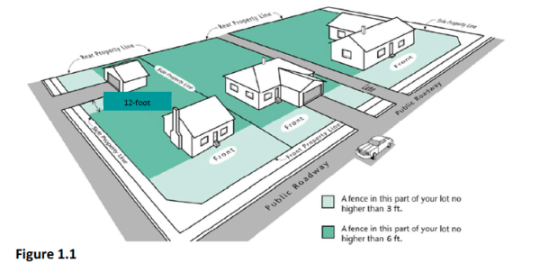
- Fences in Front Yard and Street Side Yard. Except as otherwise provided herein, no fence or wall or other similar structure exceeding 48 inches in height shall be erected within a front yard or a street side yard.
Adopted by Ord. 2016-20 on 7/15/2016
Amended by Ord. 2018-17 on 7/17/2018
Amended by Ord. 2021-19 on 9/7/2021
- Exceptions to Height Limitations. Roof structures for the housing of elevators, stairways, tanks, ventilating fans or similar equipment required to operate and maintain the building, parapet walls, skylights, towers, steeples, flagpoles, chimneys, water tanks, wireless or television masts, theater lofts, silos or similar structures may be erected above the height limits herein prescribed, but no space above the height limit shall be allowed for the purpose of providing additional floor space for human occupancy.
- Maximum Height of Accessory Building. No building which is accessory to a single-family or a multiple-family dwelling with four or fewer dwelling units shall be erected to a height greater than 20 feet without a conditional use permit.
- Minimum Height of Main Building. No dwelling shall be erected to a height less than one story above grade except earth-sheltered dwellings authorized by the provisions of this Title.
- Every Building on Legally Created Lot or Parcel. Every building shall be located and maintained on a legally created lot or parcel as defined in this Title, unless such lot or parcel is a legally nonconforming lot or parcel. Not more than one single-family dwelling or commercial structure shall occupy any one lot or parcel except as authorized by the provisions of this Title. Any development or use of a parcel located outside a recorded subdivision shall comply with CZC 12.55.132 (Development or Use of Parcel).
- Sale or Lease of Required Land. No land needed to meet the size, width, yard, area, coverage, parking or other requirements of this Title shall be sold, leased, or otherwise transferred away, whether by subdivision lot line adjustment or metes and bounds, so as to create or increase the nonconformity of a lot or parcel, building, or site development. No lot or parcel having less than the minimum width and area required by the zone in which it is located may be divided from a larger parcel of land, except as permitted by this Section or by the Board of Adjustment pursuant to the requirements of this Title.
- A reduction in the minimum required area of a lot or parcel owned by the City, County, State, or other public entity or utility provider may be granted a special exception approved by the Board of Adjustment provided such lot or parcel:
- Is used exclusively for public purposes; and
- No living quarters are located thereon.
- Is used exclusively for public purposes; and
- If a portion of a lot or parcel which meets minimum lot or parcel area requirements is acquired for public use in any manner, including dedication, condemnation or purchase, and such acquisition reduces the minimum area required, the remainder of such lot or parcel shall nevertheless be considered as having the required minimum lot or parcel area if all of the following conditions are met:
- The lot or parcel contains a rectangular space of at least 30 by 40 feet, exclusive of applicable front and side yard requirements and one-half of the applicable rear yard requirements, usable for a principal use or structure;
- The remainder of the lot or parcel has an area of at least one-half of the required lot or parcel area of the zone in which it is located; and
- The remainder of the lot or parcel has access to a public street.
- The lot or parcel contains a rectangular space of at least 30 by 40 feet, exclusive of applicable front and side yard requirements and one-half of the applicable rear yard requirements, usable for a principal use or structure;
- A reduction in the minimum required area of a lot or parcel owned by the City, County, State, or other public entity or utility provider may be granted a special exception approved by the Board of Adjustment provided such lot or parcel:
- Reduction of Lot or Parcel Width and Area Requirements. Minimum lot or parcel area, or lot or parcel width requirements of this Title shall not be construed to prevent the use of a lot or parcel for a single-family dwelling so long as such lot or parcel was:
- Held in separate ownership on the effective date of this Title; and
- Was legally created when it became nonconforming as to area or width.
- Held in separate ownership on the effective date of this Title; and
- Reduction of Minimum Yard Requirement. Any lot or parcel under separate ownership from adjacent lots or parcels, and recorded before the effective date of this Title which has a smaller width than required by the zone in which the lot or parcel is located shall be deemed a buildable lot or parcel if:
- For interior lots, the smaller of the two side yards is at least five feet wide and the larger is at least eight feet wide; and
- For corner lots, the street side yard is at least 15 feet wide and the other side yard is at least five feet wide.
- For interior lots, the smaller of the two side yards is at least five feet wide and the larger is at least eight feet wide; and
- Adjacent Lots or Parcels When Used As One Building Site. When a common side lot line separating two or more contiguous lots or parcels is covered or proposed to be covered by a building, such lots or parcels shall constitute a single building site and the setback requirements of this Title shall not apply to the common lot or parcel line if a document is recorded indicating the owner’s intent to use the combined lots or parcels as a single development site. The setback requirements of this Title shall apply only to the exterior side lot lines of the contiguous lots or parcels so joined.
- Double Frontage Lot. A lot or parcel having frontage on two or more streets shall be prohibited except for corner lots and double frontage lots in subdivisions which back onto streets shown on the Master Street Plan. Such double-frontage lots shall be accessed only from an internal subdivision street. Frontage on lots having a front lot line on more than one street shall be measured on one street only.
- Setback - Deck or Patio. Any part of a deck or patio covered with a roof or enclosed on two or more sides, or which exceeds three feet in height at any point above finished grade shall conform to applicable yard setback requirements.
- Setback Measurement. The depth of a required yard abutting a street shall be measured from the lot line except as set forth below:
- In blocks where more than 50% of the buildable lots or parcels have main buildings which do not meet the current front yard setback of the zone in which the block is located, the minimum front yard requirement for new construction shall be equal to the average existing front yard size on the block.
- Whenever a front, side, or rear yard abuts a public street proposed to be constructed or widened as shown on the Master Street Plan the depth of such yard shall be measured from a line which is one-half of the proposed right-of-way width from the center line of the street to be constructed or widened, or from the current lot line, whichever is greater.
- In blocks where more than 50% of the buildable lots or parcels have main buildings which do not meet the current front yard setback of the zone in which the block is located, the minimum front yard requirement for new construction shall be equal to the average existing front yard size on the block.
- Yard Space for One Building Only. No required yard or other open space around an existing building, or which is hereafter provided around any building for the purpose of complying with the provisions of this Title, shall be considered as providing a yard or open space for any other building. Nor shall any yard or other required open space on an adjoining lot or parcel be considered as providing a yard or open space on a lot or parcel whereon a building is to be erected or established.
- Lot Coverage. In no zone shall a building or group of buildings with their accessory buildings cover more than 50% of the area of the lot or parcel.
- Lot Grade. The grade of a lot or parcel along a property line shall be:
- The grade shown on an approved subdivision grading plan; or
- The naturally occurring grade.
- The grade of a slope from a property line shall not exceed 25%.
- The grade shown on an approved subdivision grading plan; or
- Multiple-Family Dwelling Unit Project Rear and Side Setback Adjustment. A multiple-family dwelling unit project in the R-M or R-H Zone consisting of real property over one acre in size, shall be allowed to utilize the following provisions for the purpose of providing more flexible and aesthetic building layout and project design.
- All minimum rear and side setbacks shall be determined by the orientation of any main building closest to the lot line. No main building shall have a rear or side setback smaller than 10 feet. Any building on a corner lot must meet the required street side yard setback of 20 feet.
- If the narrow portion of a one story building faces a rear or side property line, the setback may not be smaller than 10 feet. If the building is adjacent to a R-L Zone, the minimum setback shall increase an additional five feet per story, up to a maximum of 20 feet.
- If the long portion of a main building faces a rear or side property line, the setback shall be 20 feet.
- All minimum rear and side setbacks shall be determined by the orientation of any main building closest to the lot line. No main building shall have a rear or side setback smaller than 10 feet. Any building on a corner lot must meet the required street side yard setback of 20 feet.
- Single-Family Dwelling. Any development of a single-family dwelling or other associated single-family use on a parcel located outside a recorded subdivision shall comply with CZC 12.55.134 (Single-Family Development on Parcel).
- Commercial, Industrial, or Other Use. Any commercial, industrial, public or civic, multi-family, or other non-single-family development or use on a parcel located outside a recorded subdivision shall comply with CZC 12.21.110 (Site Plan Review).
- Permitted Use Permit. The Zoning Administrator is authorized to issue a permitted use permit for the development of a single-family dwelling or other associated single-family use on a parcel located outside a platted subdivision in accordance with the procedures and standards for review as set forth in this Section and CZC 12.21.090 (Permitted Use Review).
- Administrative Decision. Any decisions regarding the review, approval, or denial of a permitted use permit for the development of a single-family dwelling or other associated single-family use on a parcel located outside a platted subdivision is an administrative decision and shall be made in accordance with the provisions of CZC 12.21.060 (General Decision-Making Standards) regarding decision-making standards for administrative proceedings.
- Application Requirements. The application for permitted use permit for development of a single-family dwelling or other associated single-family use on a parcel located outside a platted subdivision shall, in addition to the requirements of Subsection CZC 12.21.090, include:
- A vicinity map showing significant natural and man-made features on the parcel and within 100 feet of the parcel;
- Boundary lines of the parcel with dimensions shown;
- Topographic contour lines at no greater intervals than five feet;
- Total acreage and tax identification number for the parcel;
- An accurate and complete survey for the parcel with traverses of the exterior boundaries of the parcel to close within a tolerance of one foot to 20,000 feet when computed from field measurements on the ground;
- Proposed addressing for the parcel in accordance with CMC 11.03.050;
- Designation of any portions of the parcel located in a floodplain zone or containing designated wetlands;
- The right-of-way lines of each street, and the width of any portion being dedicated and widths of any existing dedications;
- The side lines of all recorded and proposed easements shall be shown by fine dashed lines. The width of all easements and sufficient ties thereto to locate the same with respect to the parcel shall be shown. All recorded and proposed easements shall be clearly labeled and identified;
- A description or layout of existing and proposed utilities, including culinary water, irrigation water, sewer, stormwater, electrical, and gas service;
- Satisfactory evidence that all utilities and services will be available for the parcel and that the utilities and easements therefor have been reviewed by the utility providers;
- Construction plans in accordance with the requirements and standards set forth in CMC 15.07 (Public Improvements) for any required public improvements;
- Improvements Agreement bond acceptable to the City and bond for any required public improvements in accordance with CMC 15.04.090; and
- A current title report disclosing all recorded matters of title regarding the parcel which is prepared and dated not more than 30 days from the date of submittal of the application for permitted use permit.
- Parcel Development Requirements. Any development of a single-family dwelling or other associated single-family use on a parcel located outside a platted subdivision shall:
- Provide all necessary street and public improvements in accordance with CZC 12.55.190;
- Provide all necessary street and right-of-way dedication in accordance with CZC 12.55.190;
- Provide all required public utility easements and other necessary easements in accordance with CMC 15.05.060;
- Pay all applicable development and impact fees; and
- Comply with all applicable provisions of CMC 15.05 (General Requirements for All Subdivisions) specifically related to lot development standards and restrictions.
- General Provisions. Outdoor lighting fixtures shall be arranged to direct light away from adjoining residential property.
- Lighting fixtures mounted on utility poles shall be fully shielded, cut-off type fixtures that will not allow light dispersion or direct glare to shine above a 90 degree horizontal plane from the base of the fixture.
- Detached lighting of signs, buildings and displays shall be directed downward. Uplighting shall be prohibited except as allowed in landscaped areas as part of an approved site plan, conditional use permit, or other plan or permit.
- Electrical service to outdoor lighting fixtures shall be underground unless fixtures are mounted directly on utility poles.
- Lighting fixtures mounted on utility poles shall be fully shielded, cut-off type fixtures that will not allow light dispersion or direct glare to shine above a 90 degree horizontal plane from the base of the fixture.
- Exemptions. The following types of outdoor lighting shall be exempt from the provisions of this Section:
- Holiday lighting during the months of November, December and January, provided such lighting does not create dangerous glare on adjacent streets or property;
- Temporary lighting for temporary uses approved as part of a temporary use permit pursuant to CZC 12.56 (Temporary Uses);
- Lighting associated with agricultural operations;
- Construction or emergency lighting, provided such lighting is temporary and is discontinued when the need for such lighting ends; and
- Roadway lighting.
- Holiday lighting during the months of November, December and January, provided such lighting does not create dangerous glare on adjacent streets or property;
The Zoning Administrator shall not authorize a building permit for a dwelling located on a lot or parcel accessed only by a private right-of-way except under one of the following conditions:
- Nonconforming Lot or Parcel. The lot or parcel was legally created and recorded prior to the effective date of this Title;
- Variance. A variance is granted by the Board of Adjustment; or
- Planned Development or Condominium. The lot or parcel is part of an approved planned development or condominium.
- Authorized. A second kitchen shall not be created within a dwelling unit unless such kitchen meets the following requirements:
- The dwelling unit has only one:
- Front entrance;
- Street address; and
- Electrical meter;
- Front entrance;
- An interior access is maintained to all parts of the dwelling with no keyed or deadbolt locks, or other manner of limiting or restricting access to the second kitchen from the remainder of the dwelling;
- The second kitchen is part of the primary structure; and
- The dwelling owner executes a written document prescribed and recorded by the City which declares that the dwelling will not be converted into two or more dwelling units without prior approval by the City.
- The dwelling unit has only one:
- Occupancy Limitation. When a second kitchen is approved pursuant to Subsection (a), both present and future owners of the premises shall limit the use of the dwelling unit to family occupancy only and no roomers or boarders shall be permitted.
- Inspections. Upon request by the City, the dwelling owner shall allow inspection of the dwelling unit at reasonable times to determine compliance with this Section.
- Street Improvements Required. No construction shall be permitted on an unimproved lot or parcel unless planned street improvements abutting the lot or parcel, as shown on the Master Street Plan, including without limitation, sidewalk, curb and gutter, parking strips and associated landscaping, street pavement and fire hydrant improvements, are provided simultaneously in conformance with CMC 10.04.150 and applicable Construction Codes. Constructing such improvements shall be a condition precedent to final inspection and occupancy of any building and other improvement on the lot or parcel, subject to the provisions of this Section. Such improvements shall conform to City Standards and Specifications.
- Dedication and Construction of Improvements. When widening of a public street is planned, as shown on the Master Street Plan, street right-of-way and frontage improvements associated with proposed development shall be dedicated to the public and improved without cost to the City to the extent the such improvements are roughly proportional to the developer's fair share of needed public improvements, as determined by the Planning Commission after receiving a recommendation from the City Engineer.
- Appeal. If a street dedication and improvement requirement is alleged to not be roughly proportional to the demand created by new development, such requirement may be appealed to the Board of Adjustment as provided in CZC 12.21.200.
- Deferral. In limited circumstances, upon the request of the applicant, the City may defer or waive the installation of any required street improvements in accordance with the provisions of CZC 12.55.200.
In limited circumstances, the City may allow the developer to defer or waive the installation of any required public improvements when deemed appropriate in accordance with and subject to the provisions of CMC 10.04.170.
Any developer who voluntarily installs at his or her own expense street improvements associated with an approved development permit may receive reimbursement of part of that expense as follows:
- Written Agreement. The developer installing the street improvements shall enter into a written reimbursement agreement with the City prior to construction of the improvements.
- Calculation and Payment of Reimbursement.
- The amount of the reimbursement shall be limited to improvements which:
- Provide a direct benefit to property abutting such improvements; and
- Are greater than the developer's roughly proportional share of improvements needed to service the development.
- Provide a direct benefit to property abutting such improvements; and
- If within 10 years from the date of the reimbursement agreement, the property abutting such street improvements is developed, the developer who installed the street improvements may, when abutting development is completed, request reimbursement from the City for such improvements as provided in this Section.
- Funds for such reimbursement shall come from the person who develops the property abutting the previously installed street improvements. Such person shall pay to the City the cost of such street improvements as provided in Subsection (b)(3).
- In no event shall the amount of a reimbursement exceed the amount actually collected by the City from an abutting developer.
- Money paid by an abutting developer pursuant to this Section is separate from and in addition to payment of any other street related fees.
- Funds for such reimbursement shall come from the person who develops the property abutting the previously installed street improvements. Such person shall pay to the City the cost of such street improvements as provided in Subsection (b)(3).
- The reimbursement payment for street improvements shall be based on average improvement costs over the last two years as determined by the City.
- The amount of the reimbursement shall be limited to improvements which:
- Reimbursement From Abutting Owners. If the City installs street improvements at City expense, the City may receive reimbursement from abutting property owners when such property is developed, pursuant to this Section. The agreement described in Subsection (a) shall not be required for reimbursement to the City.
- Timing of Payment. A reimbursement payment required pursuant to this Section shall be paid to the City in its entirety prior to final inspection and approval of an occupancy permit. The rate of reimbursement per frontage foot shall be the rate in effect when the improvements are made.
To avoid creating a visual obstruction and to promote public safety, a fence, wall, sign, or other similar structure or landscaping located in a required front yard shall meet the following requirements:
- Driveway. No sight-obscuring fence, wall, sign, or other similar structure, or landscaping which exceeds two feet in height shall be placed within a triangular area formed by a driveway line, the street property line, and a line connecting them at points 12 feet along the driveway line and 12 feet along the street property line or back of sidewalk, whichever is greater, except for a reasonable number of trees pruned high enough to permit unobstructed vision for drivers of motor vehicles.
Figure 1. Driveway Sight Triangles
- Clear View of Intersecting Street. In all zones, no fence, wall, sign, or other similar structure, or landscaping which exceeds two feet in height shall be placed on any corner lot within a triangular area formed by the street property lines and a line connecting them at points 30 feet from the intersection of the street curb lines, except for public safety signs and equipment. Tree canopies pruned to seven feet above grade are permitted provided no tree trunk shall be located inside the clear view area. Trees existing as of the date of adoption of this Ordinance with trunks located within the clear view area defined herein may remain at the discretion of the City based upon safety and visibility standards, but may not be replaced once removed.
Figure 2. Street Intersection Sight Triangles.

- Drinking Water Source Protection Ordinance. The City has enacted CMC 9.3 known as the Drinking Water Source Protection Ordinance to insure the provision of a safe and sanitary drinking water supply for the City by the establishment of drinking water source protection zones surrounding drinking water wells and springs that are supply sources for the public water systems within the City and by designation and regulation of property uses and conditions that may be maintained within such zones.
- Compliance with Drinking Water Source Protection Ordinance. All use, construction, and development of or activity on property located within the jurisdiction of Centerville City shall be subject to and comply with applicable provisions of the Drinking Water Source Protection Ordinance as set forth in CMC 9.3.
- Drinking Water Source Protection Regulations. Pursuant to the requirements of Utah Code § 19-4-113 requiring the City to adopt a zoning provision regulating the storage, handling, use, or production of a hazardous or toxic substance within a drinking water source protection zone, the City hereby adopts and incorporates herein the provisions of CMC 9.3.090 regarding Uses and Restrictions within Protection Zones. All applicable exemptions, exclusions and definitions set forth in CMC 9.3 are also adopted and incorporated herein. The Drinking Water Source Protection Zones within the City are more particularly defined and designated in CMC 9.3.070 and incorporated herein by this reference.
- Enforcement. Any violation of this Section may be enforced as a Zoning Code violation in accordance with applicable provisions of this Title and/or as a violation of CMC 9.3 as more particularly set forth therein.
The following criteria relates to the raising of chickens and/or rabbits for the purpose of animal and fowl for recreation and family food production within approved zones found in CZC 12.36 (Table of Uses).
- Allowance. The raising of rabbits and hen chickens (roosters prohibited), shall be allowed as an accessory use within the Agricultural Zones and Residential-Low (R-L) Zone for personal family food production by permit only.
- No more than a combination of 10 hen chickens/rabbits shall be allowed on a single lot; provided, the number of rabbits shall not exceed six.
- A permit shall be obtained from the City as described in CZC 12.21.090. In addition to the permit application forms, the City shall provide with all permit application packets, educational information as deemed necessary and appropriate by the City, including, but not limited to, information regarding the raising of chickens or rabbits, poultry and rabbit health care, and maintenance issues. All permits shall be non-transferable to another person or property. Permits shall expire after 12 months of continuous non-use. City Staff shall send out an Annual Survey to determine status of permits. All permit applications shall also include the following:
- The name, address, email and telephone number of applicant.
- Total number of hen chickens/rabbits requested.
- Site plan indicating the location and dimensions of coop/cage, property lines, fencing.
- Applicable application fee as set forth in the City Fee Schedule.
- An acknowledgment and consent form requiring signature from the applicant that he or she has read the supplemental educational information and agrees to abide by the terms and conditions of applicable ordinances. The acknowledgment shall also include language acknowledging that the permit is not transferable to another person or property and expires after one year of non-use.
- The name, address, email and telephone number of applicant.
- Any roosters hatched and any chickens exceeding the allowed total or combined number of 10 shall be properly removed from the property within five months of age.
- The number of rabbits born that exceed the allowed total or combined number of six shall be removed within five months of age.
- No more than a combination of 10 hen chickens/rabbits shall be allowed on a single lot; provided, the number of rabbits shall not exceed six.
- Containment.
- All hen chickens/rabbits shall be contained within a proper coop/cage for their containment. In addition to the proper coop/cage requirement, hen chickens/rabbits can be free-ranged within a fenced run or a fully fenced backyard sufficient for containment. All hen chickens shall have their wings regularly clipped.
- Coops/cages shall be detached from the home and shall be at least six feet from any on-site structure, at least 18 feet from an adjacent dwelling and three feet from any rear or side property line.
- Coops/cages shall provide at least two and one-half square feet per chicken/rabbit.
- Coops/cages shall not be larger than 120 square feet unless a building permit is issued for its construction.
- All hen chickens/rabbits shall be contained within a proper coop/cage for their containment. In addition to the proper coop/cage requirement, hen chickens/rabbits can be free-ranged within a fenced run or a fully fenced backyard sufficient for containment. All hen chickens shall have their wings regularly clipped.
- Maintenance.
- All feed shall be properly stored within a rodent proof container.
- Coops/cages and other enclosures shall be maintained in a sanitary condition and shall be cleaned as necessary as to prevent any odor detectable at the property line of adjacent parcels.
- All feed shall be properly stored within a rodent proof container.
- Slaughtering. The slaughtering of hen chickens/rabbits shall be permitted for personal food use with all discarded material being placed within a secured container and disposed of properly.
- Removal. Roosters, hen chickens and rabbits that are no longer desired or in excess of the allowed number shall be properly slaughtered and disposed of or removed from the property. It shall be strictly prohibited for unwanted animals to be deposited and abandoned at an off premise location within the City or County.
- Nuisance. It shall be unlawful for any person to keep any chickens/rabbits in a manner contrary to the provisions of this Section. Any such violation shall be subject to enforcement procedures found within CZC 12.23 (Enforcement) and/or be subject to the provisions of City/County Animal Control regulations.
The following criteria relates to the keeping of one or more colonies of bees within the City.
- Allowance. The keeping of bees shall be allowed as a permitted use within the Agricultural–Low (A-L) or Residential–Low (R-L) Zones. All apiaries within these zones are permitted for personal, family, and recreational enjoyment, without need of obtaining any approval or permit from the City. However, such allowance does not relieve any person or entity from complying with the provisions of this Section or other applicable County or State regulations. Apiaries shall not be kept for a commercial production purpose, which is considered an agricultural industry use.
- Unlawful Conduct. It shall be unlawful for any beekeepers to keep any colony or colonies in such a manner or of such disposition as to cause any unhealthy condition, interfere with the normal use and enjoyment of human or animal life of others, or interfere with the normal use and enjoyment of any public property or property of others.
- Flyways. In each instance in which any colony is situated within 25 feet of a public or private property line of the parcel, tract, or property upon which the apiary is situated, as measured from the nearest point on the hive to the property line, the beekeeper shall establish and maintain a flyway barrier at least 6 feet in height consisting of a solid wall, fence, dense vegetation or combination thereof that is parallel to the property line and extends 10 feet beyond the colony in each direction so that all bees are forced to fly at an elevation of at least 6 feet above ground level over the property lines in the vicinity of the apiary.
- Water. Each beekeeper shall ensure that a convenient source of water is available to the bees at all times during the year so that the bees will not be encouraged to congregate at swimming pools, pet watering bowls, bird baths or other water sources where they may cause human, bird or domestic pet contact.
- Beekeeping Equipment. Each beekeeper shall ensure that no unused or abandoned bee comb or other beekeeping equipment are left upon the grounds of an apiary site. Upon removal from a colony, all such equipment shall promptly be disposed of in a sealed container or placed within a secured building or other bee proof enclosure.
- Number of Colonies. It shall be unlawful to keep more than the following number of colonies on any parcel, tract, or property within the city, based upon the size or configuration of the tract on which the apiary is situated:
- ½ acre or less tract size – up to four colonies
- Over ½ acre to 1 acre tract size – up to six colonies
- Over 1 acre tract size – up to eight colonies
- Nuisance. It shall be unlawful for any person to keep any colony or associated beekeeping equipment in a manner contrary to the provisions of this Section. Any such violation shall be deemed a nuisance and shall be subject to enforcement procedures found in CZC 12.23 (Enforcement) and/or be subject to the provisions of any other applicable enforcement procedures deemed necessary to remedy a violation.
Body Art Facilities and Permanent Cosmetics, as defined in CZC 12.12.040, are regulated activities governed by County and State laws, ordinances, and regulations, including, but not limited to, Utah Code § 26B-7-402 authorizing the State Department of Health and Human Services to promulgate minimum rules of sanitation for body art facilities, and the Davis County Body Art Regulations adopted by the Davis County Board of Health regulating body art and body art facilities within Davis County. Any such facilities permitted herein shall be subject to City, County, and State standards, regulations, and permitting requirements.
12.56.020 Scope
12.56.030 Definitions
12.56.040 Permitted Use
12.56.050 Development Standards - Permitted Use
12.56.060 Conditional Use Permit Required
12.56.070 Development Standards - Conditional Use
12.56.080 Development Standards - Large Events
The purpose of this Chapter is to accommodate certain land uses which are temporary in nature and not allowed as permitted or conditional uses in the zone where a temporary use is proposed. This Chapter allows these uses under certain conditions to protect the owners, occupants, and users of adjacent property from the negative effects of a temporary use.The provisions of this Chapter shall apply to the temporary uses enumerated herein. Any use not conforming to the requirements of this Chapter shall be deemed a permanent use and shall be allowed only if the use is a permitted or conditional use in the zone where the use is located. The requirements of this Chapter shall not be construed to prohibit or limit other applicable provisions of this Title, the Centerville Municipal Code, or other laws. This Chapter shall not apply to activities lawfully conducted by a government agency.Certain words and phrases in this Chapter, including uses, are defined in CZC 12.12 (Definitions).
- Temporary Use Permit Required. Any person may sponsor or conduct for profit or nonprofit purposes any use set forth below subject to the issuance of a temporary use permit pursuant to the requirements of CZC 12.21.170 and the development standards set forth in CZC 12.56.050:
- Auction;
- Christmas tree sales;
- Farmers market;
- Fireworks stand;
- Model home;
- Motor vehicle sales by a licensed dealer;
- Produce stand, located on premises other than where the produce is grown;
- Temporary construction office;
- Temporary retail sales, not exceeding 200 square feet, and not associated with retail sales activities of the owner or lessee of the property where the temporary retail sales are conducted; and
- Food truck operating on public or private property at the same location for more than 10 hours per week.
- Auction;
- No Temporary Use Permit Required. No temporary use permit shall be required for the following temporary uses:
- Garage/yard sale, up to four times during a calendar year;
- Produce stand, located on premises where the produce is grown;
- Temporary outdoor retail sales associated with a general retail sales establishment or garden center;
- Food truck events as more particularly defined in CZC 12.70 (Food Trucks) which requires a conditional use permit under CZC 12.70.070.
- Garage/yard sale, up to four times during a calendar year;
The development standards set forth in this Section shall apply to any temporary use.
- Access. Specific locations shall be designated for ingress and egress of vehicular traffic and for patron admission to promote the safety of patrons, exclusion of persons not entitled to entry, and enforcement of state and local laws and ordinances. The adequacy of such access locations shall be based upon the number of patrons reasonably expected to participate in a temporary use.
- Inspection. Authorized law enforcement officers, zoning enforcement officers, fire control officers, and other government personnel may inspect a temporary use at any reasonable time to determine compliance with the provisions of this Chapter.
- Insurance. When deemed necessary by the Zoning Administrator for public health and safety reasons, a temporary use permit applicant shall provide liability insurance for the benefit of the City. Such insurance shall:
- Name the City as an insured;
- Hold the City harmless from any claim arising from personal injury or property damage resulting from the temporary use; and
- Provide that the insurance shall not be canceled prior to termination of a temporary use without first giving the City written notice of such cancellation at least 10 business days in advance.
- Name the City as an insured;
- Location. Except as otherwise provided in this Subsection, a temporary use shall be allowed in any zone. The following uses shall be located only in a public facility, commercial, or industrial zone as set forth in CZC 12.30.010:
- Christmas tree sales;
- Festival, show, exhibit, circus, carnival, outdoor dance, community fair, concert, or other activity of a similar nature;
- Fireworks stand; and
- Motor vehicle sales by a licensed dealer.
- Christmas tree sales;
- Owner Approval. The owner of the property where a temporary use is proposed shall provide a written statement authorizing a proposed temporary use before a temporary use permit is issued.
- Parking. Off-street parking associated with a principal permitted or conditional use on the lot or parcel where a temporary use is located shall be made available for the temporary use. The property owner shall provide a written statement authorizing the use of such parking before a temporary use permit is issued.
- Time Limit. The duration of a temporary use permit shall be as follows:
- Auctions: Three days per event and not more than four events per year.
- Christmas tree sales and motor vehicle sales by a licensed dealer: 45 days once per year.
- Farmers market and produce stand: 90 days once per year.
- Festival, show, exhibit, circus, carnival, outdoor dance, community fair, concert, or other enterprise of a similar nature: 10 days per event and not more than two events per year.
- Fireworks stand: 30 days once per year.
- Model home and temporary construction office: For the duration of construction activity so long as construction is diligently pursued and the office and/or model home are located on property under construction or development.
- Temporary retail sales: 10 days per event and not more than four events per year.
- Auctions: Three days per event and not more than four events per year.
- Trash Removal and Restoration. Within one day after termination of a temporary use all trash shall be removed and within seven days the temporary use site restored to its prior condition.
Temporary uses for large events where more than 50 persons are expected to participate at one time shall conform to the development standards set forth in CZC 12.56.050 and additionally to the following requirements:
- Access. Specific locations shall be designated for ingress and egress of emergency vehicles, including appropriate barriers to regulate vehicular and pedestrian traffic.
- Control Plan. A plan shall be approved establishing adequate provisions for traffic control, crowd control, patron control, and enforcement of City ordinances, state and federal laws and any other applicable regulations, including, but not limited to, fire, health, security, and Americans with Disability Act regulations.
- Emergency Services. First aid supplies and equipment, and emergency medical services shall be made available to meet public health and safety concerns or legal requirements.
- Parking. Temporary off street parking shall be provided at the rate of one vehicle for every four persons reasonably expected to participate. Such parking need not be hard surfaced. If parking spaces are not marked, parking personnel shall be present to insure orderly and safe ingress and egress from the parking area.
- Sanitation Facilities. Adequate sanitation facilities shall be provided based on the duration of a temporary use and on the number of persons reasonably expected to participate.
- Security. A plan shall be approved establishing the number and type of enforcement and security personnel that will be present to monitor and facilitate the use and to provide participant management and direction.
12.60.020 Scope
12.60.030 Definitions
12.60.040 Approval And Authorization
12.60.050 Use Allowed
12.60.060 Limitations, Termination, And Exemptions
12.60.070 General Development Standards
12.60.080 Design Standards
12.60.090 Occupancy Requirements, Licenses, And Owner Affidavits
12.60.100 Violations And Enforcement
12.60.110 Other Applicable Regulations And Codes
The purpose of this Chapter is to establish the use and development regulations for the allowance of internal accessory dwelling units (Internal ADUs) within the City. These regulations are intended to provide opportunity for an internally located secondary separated living quarters (i.e., dwelling unit) within a primary single-family dwelling in accordance with applicable State law, including, but not limited to Utah Code § 10-21-303.
The requirements of this Chapter shall apply to any Internal ADU created or established within the City. Such requirements shall not be construed to prohibit or limit other applicable provisions of this Title, the Centerville Municipal Code, or other laws.
Certain words and phrases in this Chapter, including uses, are defined in CZC 12.12 (Definitions). In addition to the definitions set forth in CZC 12.12 (Definitions), the following words and phrases shall have the following meanings:
- Internal Accessory Dwelling Unit (Internal ADU). An internal accessory dwelling unit means an accessory dwelling unit created within a primary dwelling as more particularly defined in Utah Code § 10-20-612.
- Primary Dwelling or Primary Single-Family Dwelling. Primary dwelling or primary single-family dwelling means a single-family dwelling that is detached and is occupied as the primary residence of the owner of record as more particularly defined in Utah Code § 10-20-612.
The Zoning Administrator is authorized to issue permits for Internal ADUs in accordance with the procedures and objective standards for review as set forth in this Chapter and as set forth in CZC 12.21.090 (Permitted Use Review). Decisions regarding the review, approval, or denial of Internal ADUs are administrative proceedings and shall be made in accordance with the provisions of this Chapter and CZC 12.21.060 regarding decision-making standards for administrative proceedings.
Internal ADUs are allowed in residential zones as set forth in CZC 12.36 (Table of Uses). Permitted and conditional uses are indicated by “P” or “C,” respectively. Uses not permitted are indicated by “N.”
- Use in Combination. An Internal ADU shall be established as an internally located secondary accessory dwelling unit and shall only be established in combination within a primary single-family dwelling.
- Owner Occupancy Required. An Internal ADU shall only be established for a primary single-family dwelling that is occupied by an owner in accordance with the “Owner Occupancy” requirements of CZC 12.60.090.
- Number allowed. Only one Interna ADU is allowed for:
- A lot, parcel, or tract of land greater than 6,000 square feet; and
- A primary single-family dwelling located within a primarily residential use zone as more particularly designated in CZC 12.36 (Table of Uses).
- Location or Placement. An Internal ADU may be integrated within or as a part of the primary single-family dwelling structure and shall maintain the character of the primary single-family dwelling structure and such neighborhood context.
- Separate Dwelling Units. Any portion of a primary single-family dwelling that has been sectioned off, mechanically, physically, or by other means, so that any occupant in the primary single-family dwelling does not have full and free access to the separated portion of the dwelling and such separated area contains living quarters which provide sleeping, sanitary, and fixed kitchen facilities, or any separate accessory building or structure containing the same, shall be subject to the provisions of this Chapter, regardless of the relationship of the occupants.
- No Short-Term Rental. An Internal ADU may not be used as a short-term rental for fewer than 30 consecutive days as more particularly defined and regulated pursuant to Utah Code § 10-8-85.4. In order to regulate and prohibit short-term rentals, the City shall require and record a notice for any approved Internal ADU with the Davis County Recorder’s Office in accordance with Utah Code § 10-20-303.
- Termination of Internal ADU Use. The approval permit for an Internal ADU shall become null and void if the occupancy requirements of this Chapter are not satisfied, or the owner declares termination through writing or through neglect or any other confirmed non-corrected action that violates the provisions of this Chapter. Upon such termination of an Internal ADU use, the owner shall remove one or more features that make up an Internal ADU including but not limited to living, sleeping, or kitchen facilities, including electrical, gas, or plumbing, as deemed acceptable to the City to render the Internal ADU removed or unusable.
- Exemptions. Internal ADUs shall not be included in the gross density calculations for primarily single-family zoning districts.
The development standards set forth in this Section shall apply to any Internal ADU that is created or established within the City. The purposes of these development standards are to ensure that the Internal ADU is clearly and distinctly an accessory use and internally located as part of the approved primary single-family dwelling use located on the property.
- Creation. An Internal ADU shall only be established through the following methods:
- Converting existing living area, attic, basement, or other area of a primary single-family dwelling. The conversion of the primary single-family dwelling’s garage space is prohibited without providing the required parking stalls in another appropriately City approved location;
- Adding floor area to the primary single-family dwelling; or
- Integrating an Internal ADU into the design plan for new construction of a primary single-family dwelling.
- Minimum Lot Size. The minimum lot size for establishing an Internal ADU shall be 6,000 square feet or more within a primary single-family dwelling.
- Setbacks. An Internal ADU created within or attached to the primary single-family dwelling shall meet the applicable front, side, and rear yard setbacks for “main buildings” as listed in the development standards of the respective zone.
- Heights. An Internal ADU created within or attached to the primary single-family dwelling shall meet the applicable height requirement for primary or main buildings as listed in the development standards of the respective zone.
- Parking. At least one additional parking space shall be provided for an Internal ADU; provided, however that the existing parking requirements for the primary single-family dwelling are to remain in place or restored if missing. The Internal ADU parking space may be located in tandem with other required parking spaces. All required parking spaces must be located behind the front yard setback line of the lot.
- Bulk Yard Area Limitation. The combined building footprint coverage of a lot area for the primary single-family dwelling and the Internal ADU shall not exceed the impervious surface allowance for the respective zoning district in which it is located.
The design standards set forth in this Section are to apply to any Internal ADU that is created or established within the City. The purposes of these design standards are to ensure Internal ADU compatibility with the general pattern, character, and livability of Centerville’s typical low density single-family neighborhoods.
- Exterior Finish Materials. The exterior finish materials should be compatible with, or visually appear to be harmonious with the type, size, and colors of the finish materials utilized on the primary single-family dwelling on the lot or parcel.
- Location of Entrances. Only one additional entrance may be located on the wall facade that can be viewed from the public street directly adjacent to the same lot or parcel in which the Internal ADU is located. All other entrances must be located on wall facades facing interior to the lot.
- Ground Entrance Restrictions. Ground entrances and coverings are prohibited on a wall facade facing a perimeter lot line, unless such wall façade is at least 10 feet from a perimeter lot line and such coverings are located at least 6 feet from any perimeter lot line.
- Upper Story Entrance Restrictions. Upper story entrances and coverings (e.g., access from balconies and decks) having no other ground entrances are prohibited on a wall façade facing a perimeter lot line unless such wall façade is located 10 feet from the perimeter lot line and such coverings are located at least 6 feet from any perimeter lot line.
- Roof Pitch. The roof pitch should be compatible or visually appear to be harmonious with the roof pitch style of the primary single-family dwelling on the lot or parcel in which the ADU is located.
- Windows. Windows should be compatible or visually appear to be harmonious in proportion (i.e., width to height) and orientation (i.e., horizontal, or vertical) to windows used for the primary single-family dwelling.
- Eaves. Building eaves for Internal ADUs should meet one of the following designs:
- The eaves are to project from the walls the same distance as the eaves on the primary single-family dwelling.
- The eaves are to project from the walls at least one foot on all elevations.
- If the primary single-family dwelling style has no eaves, then eaves are not required for the Internal ADU.
- Design. The Internal ADU shall be designed and maintained in a manner that does not change the appearance of the primary single-family dwelling.
- Exceptions. If there is a conflict between these design standards and the adopted Construction Codes of the City, then the applicable Construction Code shall govern that particular design element.
The occupancy requirements set forth in this Section shall apply to any ADU that is created or established within the City. The purposes of these occupancy requirements are to accommodate internal secondary separated living quarters (i.e., dwelling unit) with reasonable limitations on their use and to minimize the impact on neighboring properties and the desired setting of the City’s single-family neighborhoods.
- Definitions and Terms. The following definitions or terms are applicable to the creation and use of Internal ADUs;
- Owner. An owner is defined as a person occupying the premises as their sole primary residence and having at least 50% or greater ownership interest in the property.
- Full-Time Residency. Full-time residency means the owner must live in a dwelling for at least 183 consecutive calendar days of each calendar year.
- Internal ADU Occupation. The Internal ADU is exclusively used for other family members or for long-term rental with a minimum rental period of 30 days or more.
- Owner Occupancy Affidavit. A signed and notarized owner-occupancy acknowledgement for the property for sanctioning an Internal ADU and filed with the City Recorder’s Office and/or recorded at the Davis County Recorder’s Office.
- Temporary Owner Absence Waiver. An approval granting a waiver of the occupancy requirement due to specific short-term or temporary absences.
- Full Time Owner Residency. Either the primary single-family dwelling or the Internal ADU is to be occupied by a full-time residency property owner as shown on the Davis County Tax Assessment rolls.
- Owner Occupancy Affidavit and License. An Internal ADU owner must apply for an Internal ADU License and sign an “owner occupancy affidavit” with the City and have it filed with the City Recorder and/or recorded at the Davis County Recorder’s Office prior to receiving authorization of constructing and/or use of an Internal ADU. Such license and affidavit shall at minimum establish the following:
- That he/she/they are owner(s) of the property located in Centerville, Utah.
- That he/she/they applied and intend to receive approval to construct or use an Internal ADU pursuant to Centerville City ordinances.
- That the owner(s) of the property confirm that the Internal ADU will be used for the purpose of offering a long-term rental of at least 30 days or more to any occupant of the Internal ADU.
- That an owner with at least a 50% interest in the property will occupy either the primary single-family dwelling or Internal ADU for six months of each calendar year, except where a “temporary owner absence waiver” is granted in accordance with Subsection (d).
- That if the owner(s) of property are unable or unwilling to fulfill the requirements for use of an Internal ADU, then the owners agree to remove one or more features that make it an Internal ADU, including but not limited to living areas, sleeping areas, or kitchen facilities, including electrical, gas, or plumbing and further agree to terminate, in writing, the Internal ADU permit and approval.
- That the license and affidavit shall run with the land and be binding upon all owners, heirs, and assigns, and upon all parties acquiring any right, title, or interest in the property.
- That the owners and their heirs, successors, and assigns will inform all prospective purchasers of the property of the terms and conditions of the permit authorizing the ADU.
- Recorded Notice of Internal ADU. On or after October 1, 2021, the City may record against the property a notice of any approved Internal ADU in the Davis County Recorder’s Office in accordance with Utah Code § 10-20-303.
- Temporary Owner Absence Waiver. The owner(s) shall comply with the Full-Time Owner Residency Requirements, or such absence or abandonment shall terminate the Internal ADU permit, as approved by the City. Nonetheless, an owner may receive a one-time waiver of the occupancy requirement upon submitting in writing evidence showing good cause of temporary absence, such as:
- A job re-location;
- Military assignment;
- Medical or other care of others;
- Sabbatical leave;
- Educational pursuits; or
- Personal Illness.
A one-time waiver of the occupancy requirement will then be authorized, by the City’s Zoning Administrator, up to a maximum of three years and one month. Thereafter, if not re-occupied by the property owner, then the Internal ADU permit shall be deemed null and void and one or more features constituting the Internal ADU shall be removed immediately, upon notice from Centerville City, or the property will subject to applicable enforcement measures.
Adopted by Ord. 2021-18 on 9/7/2021
Amended by Ord. 2021-25 on 11/16/2021
Amended by Ord. 2026-01 (LUDMA renumbering) on 2/3/2026
The applicable enforcement procedures for violations of these Internal ADU ordinance provisions shall be subject to the civil or criminal penalties of CZC 12.23 (Enforcement). Additionally, the City may utilize the enforcement provisions of Utah Code § 10-20-303 (Internal Accessory Dwelling Units) regarding violations and holding liens against the property.
The creation and use of Internal ADUs are subject to other pertinent codes, restrictions, and regulations that address applicable life, safety, and welfare concerns. Any Internal ADU shall comply with the following:
- Construction and Fire Codes. An Internal ADU shall be subject to all related regulations regarding the building construction and fire codes, as adopted by the City and State.
- Utilities and Charges. An Internal ADU shall provide the necessary utilities and services such as, but not limited to, sewer, water, gas, electricity, and garbage collection. All City provided utilities shall be established in the property owner(s) name and the property owner shall be responsible for the payment of such utility services.
- Development and Impact Fees. Internal ADUs meeting the development standards of this Title shall be exempt from payment of additional impact fees beyond the establishment of the primary single-family dwelling for the property.
- Street Addressing. An Internal ADU will not be given a new distinct address by the City. Such Internal ADUs may refer mail/parcel packages to be delivered separately by the same address as the primary building using a subsidiary numerical or alphabetical reference (e.g., 1390 West #A), as approved by the Public Works Director, local postmaster, and emergency service agencies, or by securing a separate postal box.
- Second Kitchen in Single-Family Dwelling. An Internal ADU is separate and distinct from a second kitchen authorization pursuant to CZC 12.55.160. If a property owner has an approved second kitchen that the property owner wants to convert into or eliminate to allow for an Internal ADU, the property owner shall notify the City of the second kitchen authorization as part of the application process for approval of an Internal ADU. Any document recorded against the property regarding conversion of or limitations on the second kitchen shall be vacated or removed from the property title prior to approval or as a condition of approval of the Internal ADU.
12.61.020 Scope
12.61.030 Landmarks Commission Review
12.61.040 Significant Historic Sites List
12.61.050 Historic Landmark Register
12.61.060 Historic Area Register
12.61.062 Deuel Creek Historic District
12.61.070 Nominations To The National Register Of Historic Places
12.61.080 Certificate Of Historic Landmark Or Area Registers
12.61.090 Removal From Historic Landmark Or Area Registers
12.61.100 Alteration/Modification Standards For Historic Assets Listed On The Historic Landmark Register
12.61.110 Complete Demolition Or Substantial Non-Approved Alteration/Modification Of Historic Assets Listed On The Historic Landmarks Register
12.61.120 Special Considerations
12.61.130 Historic Asset Recognition And Preservation Programs
12.61.140 Enforcement
12.61.150 Appeal
The City of Centerville recognizes that the historical heritage of the community is among its most valued and important assets. It is the intent of the City to identify, preserve, protect, and enhance significant historic sites, places, structures, or buildings within the City that are deemed architecturally or historically significant. By protecting such significant historic assets, they will be preserved for the use, observation, education, pleasure, and general welfare of the present and future residents of the City.The provisions of this Chapter set forth the procedures and requirements for placing real property on the Centerville Significant Historic Sites List, Centerville Historic Landmarks or Area Registers, or nominations for the National Register of Historic Places. Any nominated and listed historic asset shall be subject to the requirements of this Chapter. Such requirements shall not be construed to prohibit or limit other applicable provisions of this Title, the Centerville Municipal Code, or other laws.The Centerville Landmarks Commission is hereby designated as the official body to review all matters concerning designation, preservation, modification or demolition of any asset listed on the Significant Historic Sites List, Historic Landmark Register and Historic Area Register, or nominations of such assets to the National Register of Historic Places, within the City in accordance with the provisions set forth in this Chapter. However, the City Council shall grant all final approvals for designations to the Historic Landmark Register and the Historic Area Register, or official local sanction for the National Register of Historic Places.
- Created. There is hereby created a Centerville Significant Historic Sites List, which shall serve as a means of providing recognition to and encouraging the preservation of knowledge and information of important historic sites, places, structures, buildings, etc. within the City. The Significant Historic Sites List shall be prepared and maintained by the Landmarks Commission. The Landmarks Commission shall ensure that all nominations and any subsequent amendments or any additions thereto are approved in accordance with the provisions of this Chapter.
- Contents. The Significant Historic Sites List shall describe as concisely as possible any significant historic assets that no longer exist; assets that have been significantly modified but have significant value; or the actual location of any event that had occurred in the past that played a significant role, or had an important influence within Centerville City.
- Request for Identification. Any person, group, or governmental agency may nominate a historical asset for the Significant Historic Sites List by submitting a written request for nomination to the Landmarks Commission. The request for identification shall include the documentation of the qualifying contents and criteria set forth in this Section.
- Review of Request. Upon receipt of a written request for identification, the Landmarks Commission shall review the submitted nomination at the Commission’s next scheduled meeting, permitting adequate time for processing application and notice of the same. The Landmarks Commission shall review the nomination in accordance with the criteria set forth in this Section and shall approve, approve with conditions, or deny the same for placement on the Significant Historic Sites List.
- Notification. When a historic asset is officially nominated to the Significant Historic Sites List by the Landmarks Commission, the Commission shall promptly notify any applicable owner in writing of the nomination to the listing. Upon official acceptance of the nomination, the historic asset shall be eligible for any recognition programs established by the City.
- Identification Criteria. The Landmarks Commission may nominate any historic asset to the Significant Historic Sites List, in accordance with the procedures set forth in this Section, if it meets all the criteria set forth below:
- Existing assets or removed assets shall be located or have taken place within the official boundaries of the City;
- It was built or occurred at least 50 years in the past;
- It is directly associated with events of historic significance in the community;
- It is closely associated with the lives of persons who were of historic importance to the community; or
- It exhibited significant architectural design or methods of construction that were used within the historic period it was established.
- Existing assets or removed assets shall be located or have taken place within the official boundaries of the City;
- Created. There is hereby created a Centerville Historic Landmark Register, which shall provide further recognition of significant individual historic assets and provide certain benefits and rehabilitation guidelines for such significant assets as an incentive for their preservation. The Historic Landmark Register shall be prepared and maintained by the Landmarks Commission with the consent of the City Council in accordance with the provisions set forth in this Section. The Landmarks Commission shall ensure that nominations to the Historic Landmark Register and any subsequent amendments or any additions thereto are approved by the City Council and filed with the City Recorder and the Davis County Recorder's Office.
- Contents. The Historic Landmark Register shall describe as concisely as possible each site, structure or building, the date(s) of its occurrence or construction as nearly as can be determined, the qualifications for including it on the Historic Landmark Register, and the name and address of the current owner of property as shown on the records of the Davis County Recorder.
- Request for Designation. Any owner of property may nominate his or her property for listing on the Historic Landmark Register by submitting a written request for designation to the Landmarks Commission. An official request for designation may be preceded by informal contacts with the property owner by members of the Landmarks Commission, City staff, or other interested parties. The written request shall include the following:
- Address and/or historic name of the property;
- Date the property was listed in the National Register or officially determined eligible and documentation supporting such listing or eligibility;
- Statement verifying the owner is indeed the legal owner of the property, according to record of the Davis County Recorder;
- Statement that the owner desires the action to designate his or her property to the Historic Landmark Register;
- Submittal of the applicable research and documentation regarding the historic asset, performed in accordance with the Utah State Historic Preservation Office standards for intensive level surveys. Copies of such documentation shall be maintained in the City's preservation files; and
- Any other information deemed necessary by the Landmarks Commission or the City Council for determining the property's eligibility for designation.
- Address and/or historic name of the property;
- Review of Request. Upon receipt of a written request for Historic Landmark Register designation, the Landmarks Commission shall review the submitted nomination at the Commission’s next scheduled meeting, permitting adequate time for processing application and notice of the same. The Landmarks Commission shall review the nomination in accordance with the criteria set forth in this Section. The Landmarks Commission shall forward its recommendation regarding the nomination to the City Council for its review and approval, approval with conditions, or denial as set forth herein.
- Designation and Notification. The City Council may designate a nomination to the Historic Landmark Register by approval and passage of an appropriate resolution. When a historic asset is officially designated to the Historic Landmark Register by the City Council, the Landmarks Commission shall record the designation certificate with the City Recorder and promptly notify the property owner in writing of the designation together with a copy of the designation certificate. Upon official approval of the nomination, assets listed on the Historic Landmark Register shall be eligible for any recognition or preservation programs established by the City.
- Approval Criteria. Any nominated historic asset may be designated to the Historic Landmark Register in accordance with the procedures set forth herein if it meets all the criteria set forth below:
- The historic asset is located within the official boundaries of the City;
- Is currently listed in the National Register of Historic Places, or it has been officially determined eligible to be listed by meeting the National Register Criteria for Evaluation, as amended;
- The historic asset was built or occurred at least 50 years in the past and at present is still in existence;
- The historic asset has substantially retained its original integrity, as defined in CZC 12.61.100(e)(2), and meets at least one of the following criteria:
- Is associated with events that have made a significant contribution to the broad patterns of the community's history;
- Is associated with the lives of persons significant in the community's past;
- Embodies the distinctive characteristics of a type, period, or method of construction, represent the work of a master, possess high artistic values, or represent a significant and distinguishable entity whose components may lack individual distinction; or
- Has yielded, or may be likely to yield, information important in prehistory or history (e.g. archaeological sites).
- Is associated with events that have made a significant contribution to the broad patterns of the community's history;
- The historic asset is located within the official boundaries of the City;
- Intensive Level Survey. Historic assets to be listed on the Historic Landmark Register which are not already listed on the National Register of Historic Places or if ineligible for such national listing, shall nonetheless be properly documented by an intensive level survey, in accordance with the Utah State Historic Preservation Office standards for intensive level surveys.
- Created. There is hereby created a Centerville Historic Area Register, which shall provide further recognition of significant historic assets and provide certain benefits and rehabilitation guidelines for such significant assets as an incentive for their preservation. The Historic Area Register shall be prepared and maintained by the Landmarks Commission with the consent of the City Council in accordance with the provisions set forth in this Section. The Landmarks Commission shall ensure that nominations to the Historic Area Register and any subsequent amendments or any additions thereto are approved by the City Council and filed with the City Recorder's Office.
- Contents. The Historic Area Register shall describe as concisely as possible the boundary or perimeter area of a historic area, street, or block, the qualifications for including it on the Historic Area Register, and the name and address of all current owners of property within the district, as shown on the records of the Davis County Recorder.
- Request for Designation. The owners of property, Landmarks Commission, or City Council may nominate an area for listing on the Historic Area Register by submitting a written request for designation to the Landmarks Commission. An official request for designation may be preceded by informal contacts with the property owners, by members of the Landmarks Commission, City staff, or other interested parties. The written request shall include the following:
- The description of the proposed area boundary or location, along with the addresses of each property within the proposed Historic Area, regardless of whether all properties are contributing historical assets and the proposed historic name desired for the proposed area.
- Statement verifying or witnessing that all owners have been notified in writing or by mailing, as addressed with the County Records, of such proposal to create a Historic Area.
- Submittal of the applicable research and documentation regarding all historic assets found within the proposed Historic Area, performed in accordance with the Utah State Historic Preservation Office standards for intensive level surveys. Copies of such documentation shall be maintained in the City's preservation files.
- Any other information deemed necessary by the Landmarks Commission or the City Council for determining the proposed Historic Area eligibility for designation.
- The description of the proposed area boundary or location, along with the addresses of each property within the proposed Historic Area, regardless of whether all properties are contributing historical assets and the proposed historic name desired for the proposed area.
- Review of Request. Upon receipt of a written request for Historic Area Register designation, the Landmarks Commission shall review the submitted nomination at the Commission’s next scheduled meeting, permitting adequate time for processing application and notice of the same. The Landmarks Commission shall review the nomination in accordance with the criteria set forth in this Section. The Landmarks Commission shall forward its recommendation regarding the nomination to the City Council for its review and approval, approval with conditions, or denial as set forth herein.
- Designation and Notification. The City Council may designate a nomination to the Historic Area Register by approval and passage of an appropriate resolution. When a historic area is officially designated to the Historic Area Register by the City Council, the Landmarks Commission shall promptly notify all property owners, within the boundary area, in writing of the designation together with a copy of the designation certificate. Upon official approval of the nomination, assets listed on the Historic Area Register shall be eligible for any recognition or preservation programs established by the City.
- Approval Criteria. Any nominated historic location may be designated to the Historic Area Register in accordance with the procedures set forth herein if it meets all the criteria set forth below:
- The historic area is located within the official boundaries of the City.
- All contributing historic assets were built or occurred at least 50 years in the past and presently exist.
- The historic area has substantially retained its original integrity and meets at least one of the following criteria:
- Is associated with events that have made a significant contribution to the broad patterns of the community's history;
- Is associated with the lives of persons significant in the community's past;
- Embodies the distinctive characteristics of a type, period, or method of construction, represent the work of a master, possess high artistic values, or represent a significant and distinguishable entity whose components may lack individual distinction; or
- Has yielded, or may be likely to yield, information important in prehistory or history (e.g. archaeological sites).
- Is associated with events that have made a significant contribution to the broad patterns of the community's history;
- Intensive Level Survey. All contributing historic assets to be used for establishing the Historic Area Registry which are not already listed on the National Register of Historic Places or if ineligible for such national listing, shall nonetheless be properly documented by an intensive level survey, in accordance with the Utah State Historic Preservation Office standards for intensive level surveys.
- The historic area is located within the official boundaries of the City.
- Nomination. The Landmarks Commission, with the approval of the property owner of record and a final recommendation by the City Council, may prepare, assist, or submit nominations for select historic assets to the National Register of Historic Places. Submittals shall follow all state and national nomination requirements.
- Purpose. The National Register is an official national list of structures considered worthy of preservation because they tell something important about a City’s past. Such importance can be at the state or local level, not just the national level. A National Register designation means a property has been officially recognized for its historic value and its preservation is encouraged.
- Benefits. The benefits of National Register listing include assistance and information concerning the preservation of the structure, possible grants for repairs or improvements, and eligibility for federal and state rehabilitation tax credits.
- Owner Obligation. A listing in the National Register does not interfere with a private property owner's right to alter, manage, or even demolish the listed property.
- Steps for Listing. The general steps for a historic asset in obtaining a listing on the National Register are as follows:
- Researching the property and its past and current owners, this includes an intensive level survey following the State Historic Preservation Office criteria.
- Documenting the property's physical appearance with photographs and floor plan drawings and measurements.
- Completion of the official National Registration form.
- Following a review by the Landmarks Commission, and approval from the property owner of record, the application shall be forwarded to the City Council for a final recommendation prior to submittal. A completed nomination shall be submitted to the State Historic Preservation office for review and submittal to the Keeper of the National Register of Historic Places.
- Researching the property and its past and current owners, this includes an intensive level survey following the State Historic Preservation Office criteria.
- Designation Optional. A designation of a historic asset on the National Register is not required for listing on the City’s Significant Historic Sites List or the Historic Area Register. However, it is strongly encouraged that any historic asset listed on the City’s local registers, also make application to be on the National Register to take advantage of federal and state programs to assist with the continued preservation of such asset.
- Designation Required. A designation of a historic asset on the National Register is required for listing on the City’s Historic Landmark Register.
- Contents. Upon City Council approval of an historic asset to the Historic Landmark Register or the Historic Area Register, a designation certificate shall be prepared and recorded with the City Recorder and placed in the associated files maintained by the Landmarks Commission. The designation certificate shall contain the following:
- The historic name of the property or district.
- The date of recommendation made by the Landmarks Commission and the date of official designation by the City Council.
- A summary or list of the significant applicable attribute(s) of the historic asset that were identified to support the designation.
- The signatures of Landmarks Commission chairperson and the Mayor.
- The historic name of the property or district.
- Owner Copy. All owners of record shall be provided a copy of the designation certificate and may obtain additional copies by written request to the Landmarks Commission.
- Recordation. Any owner of record for an historic asset may record the designation certificate with the Davis County Recorder's Office to further enhance the recognition of such asset.
- By Owner. Nothing in this Chapter shall be construed to prevent any owner of record from removing his or her historic asset from the Historic Landmark Register or the Historic Area Register, as the owner deems appropriate. Such request for removal shall be made in writing by the owner of record to the Landmarks Commission, and shall be forwarded to the City Council for acceptance. The Landmarks Commission or City Council may not withhold acceptance of any removal request, but such review and official acceptance shall be conducted by the City for informational and administrative purposes for an understanding of the request. The City shall not have any liability whatsoever for an owner's decision to remove his or her historic asset from any register.
- By Non-Owner. Any historic asset, which in the opinion of the Landmarks Commission, no longer meets criteria for eligibility may be forwarded to the City Council for removal from either the Historic Landmark Register or the Historic Area Register. Any such removal initiated by a person other than the owner of record shall be made with findings in accordance with the designation procedures and criteria set forth herein.
- Notice. When a historic asset has been removed from the Historic Landmark Register or the Historic Area Register, the Landmarks Commission shall promptly notify the owner of record in writing of the removal and shall file notice of the removal with the City Recorder and/or the Davis County Recorder's Office, as applicable.
- Placement on the Significant Historic Sites List. Any home removed from the Historic Landmark Register or the Historic Area Register, by owner or non-owner, may still qualify for placement on the Significant Historic Sites List by meeting the criteria found in CZC 12.61.040.
- Alterations or Modifications. In order to ensure the preservation of historic materials and features of Historic Landmark Register assets to the greatest extent possible, all proposed repairs, alterations or additions involving the exterior structure and/or facade of such assets shall be subject to review by the Landmarks Commission, in accordance with the provisions set forth in this Section. Any property owner desiring to keep their asset on the Historic Landmark Register shall comply with the following provisions of this Section.
- Building Permit Request. An application for a building or related permit pertaining to an asset listed on the Historic Landmark Register shall be forwarded by the Zoning Administrator to the Landmarks Commission prior to issuance. The Landmarks Commission shall promptly review the application and proposed work for compliance with the standards set forth in this Section.
- Appropriateness of Work. The Landmarks Commission shall determine the appropriateness of the work in keeping with the preservation of historic integrity of the asset and shall prepare findings for approval or denial, as follows:
- Appropriate. If the Landmarks Commission deems the proposed work appropriate, it shall notify both the owner of record and the Zoning Administrator in writing of its determination of the a appropriateness of the work and any conditions for compliance related to the alteration or modification.
- If the Landmarks Commission deems the alterations and modifications to the structure appropriate, those properties on the Historic Landmark Register (not otherwise located in the Centerville Deuel Creek Historic District) shall be eligible for the same incentives set forth in CZC 12.49.100.
- Not Appropriate. If the Landmarks Commission deems the proposed work inappropriate, it shall forward notice, to the owner of record and the Zoning Administrator, of such determination together with recommendations as to how the work may be accomplished to comply with historic preservation standards.
- If the Landmarks Commission does not approve the proposed work as "appropriate," the owner is encouraged to work with the Landmarks Commission to determine the most appropriate means of altering or modification to the property in order to maintain the historic integrity of the property.
- If the owner chooses not comply with the recommendations of the Landmarks Commission, the issuance of the building or associated permit shall be delayed up to 30 days for the documentation of existing conditions of the historic asset. After the necessary documentation time, the permit shall be issued as requested and the asset may be subject to the removal of its designation to the Historic Landmark Register.
- If the Landmarks Commission does not approve the proposed work as "appropriate," the owner is encouraged to work with the Landmarks Commission to determine the most appropriate means of altering or modification to the property in order to maintain the historic integrity of the property.
- Appropriate. If the Landmarks Commission deems the proposed work appropriate, it shall notify both the owner of record and the Zoning Administrator in writing of its determination of the a appropriateness of the work and any conditions for compliance related to the alteration or modification.
- Record Keeping. Any building permit or associated plans issued for an asset listed on the Historic Landmark Register shall be maintained by the office of the Zoning Administrator to assist in preserving and documenting the alterations or modifications made to historic assets listed on the Historic Landmark Register.
- Approval Standards. Any alteration or modification of any historic asset designated on the Historic Landmark Register shall be reviewed for appropriateness in keeping with the preservation of historic integrity of the asset. The following standards shall be used by the Landmarks Commission and/or City Council when determining the historic appropriateness of any application pertaining to the Historic Landmark Register:
- Use. The asset shall be primarily used for its intended historic purpose or be placed in a compatible new use that requires minimal change to the defining characteristics of the building and its site and/or environment.
- Character. The historic character of the asset shall be retained and preserved to the greatest extent possible. The removal of historic materials or alteration of features and spaces that characterize the asset shall be avoided.
- Developments. Each asset shall be recognized as a physical record of its time, place, and use. Changes that create a false sense of historical development, such as adding conjectural features or architectural elements from other dissimilar buildings shall not be undertaken.
- Changes. Most assets change over time; changes that have acquired historic significance in their own right shall be retained and preserved.
- Distinctive Items. Distinctive features, finishes, and construction techniques or examples of craftsmanship that characterize the historic asset shall be preserved.
- Deterioration. Deteriorated historic features shall be repaired rather than replaced. Where the severity of deterioration requires replacement of a distinctive feature, the new feature shall match the old in design, color, texture, and other visual qualities and, where possible, materials. Replacement of missing features shall be substantiated by documentary, physical, or pictorial evidence that such feature was previously present.
- Cleaning. Chemical or physical treatments, such as sandblasting, that cause damage to historic material shall not be used. The surface cleaning of structures or materials, if appropriate, shall be undertaken using the gentlest means possible.
- Resources. Significant archeological resources affected by a project shall be protected and preserved. If such resources must be disturbed, mitigation measures shall be undertaken.
- Materials. New additions, exterior alterations, modifications, or related new construction shall not destroy historic materials that characterize the asset. The new work shall be differentiated from the old and shall be compatible with the massing, size, scale, and architectural features to protect the historic integrity of the asset and its environment.
- Historic Integrity. New additions and adjacent or related new construction shall be undertaken in such a manner that if removed in the future, the essential form and integrity of the historic asset and its environment would be substantially unimpaired.
- Additional Guidelines. Additional guidelines may be used as set forth in "The Secretary of the Interior's Standards for Rehabilitating Historic Buildings."
- Use. The asset shall be primarily used for its intended historic purpose or be placed in a compatible new use that requires minimal change to the defining characteristics of the building and its site and/or environment.
- Delay of Permit. If a historic asset on the Historic Landmark Register is to be demolished or substantially altered, efforts shall be made by the City to document its physical appearance before that action takes place. Specifically, the City may delay issuing a building permit for demolition or non-approved alterations/modifications for a maximum of 60 working days in order to provide the Landmarks Commission time to document the site.
- Documentation. Upon receipt of an application for demolition or non-approved alterations/modifications of assets listed on the Historic Landmark Register, the Zoning Administrator shall notify the Landmarks Commission that such application has been made. The Landmarks Commission shall thereafter have 60 working days to document the historic asset. Documentation may include, at a minimum, exterior photographs of all elevations of the historic asset, and exterior and interior measurements of the asset in order to provide an accurate floor-plan drawing of a building. All documentation shall be kept in the City's preservation files.
- Information. The Landmarks Commission may contact the owner of record of a historic asset in order to inform the owner of the significance of the historic asset to the City and the potential loss it may have if demolished or substantially altered.
- Considerations. Historic assets designated to the Historic Landmark Register may receive special consideration in the granting of special exceptions or conditional use permits in order to encourage their preservation as deemed appropriate by the City. Any such special exception or conditional use permit granted hereunder shall be subject to continued designation of the asset on the Historic Landmark Register. If the property is removed from such designation, the special exception and/or associated permit may be revoked and/or the property deemed nonconforming to the extent of the special consideration given to the property.
- Construction Codes. In the event of rehabilitation for a historic asset, the building official shall consider the waiving certain code requirements, as provided in the Construction Codes adopted by the City.
- Assistance. An owner of historic asset designated on the Historic Landmark Register may seek assistance from the Landmarks Commission or City in applying for grants or tax credits for rehabilitating the property.
- Signs. All signs used in connection with a special exception or associated permit shall conform to the general character of the historic asset and shall be subject to the provisions of CZC 12.54 (Signs).
The Landmarks Commission is hereby charged with creating and/or recommending to the City efforts to identify, preserve, protect, and enhance the City’s historic assets, such as but not limited to the following:
- Seeking grants;
- Supporting nominations to the National Register of Historic Places;
- Commemoration plaques;
- Holding or attending educational events and programs;
- Historic preservation socials;
- Conducting historic walking/home tours;
- Rehabilitation scholarships; and
- Supporting General Plan and Zoning Code amendments that relate to historic preservation and the preservation of Centerville’s past.
12.62.020 Scope
12.62.030 Definitions
12.62.040 Permitted Use
12.62.050 Development Standards - Permitted Use
12.62.060 Conditional Use Permit Required
12.62.070 Development Standards - Conditional Use
The purpose of this Chapter is to establish use and development regulations for home occupations. These regulations are intended to ensure that limited business activities allowed in a residential zone do not disturb the residential character of a neighborhood.The requirements of this Chapter shall apply to any home occupation conducted within the City. Such requirements shall not be construed to prohibit or limit other applicable provisions of this Title, the Centerville Municipal Code, or other laws.Certain words and phrases in this Chapter, including uses, are defined in CZC 12.12 (Definitions).
- Permitted Use. Permitted home occupation uses listed in Subsection (b) may be established as a home occupation in an agricultural or residential zone as a permitted use subject to the development standards of CZC 12.62.050.
- Permitted Uses. The uses set forth below shall be allowed as permitted home occupation uses in any agricultural or residential zone:
- Family child care facility;
- Medical service;
- Personal care service;
- Personal instruction service; and
- Office, general.
- Prohibited Uses. The uses set forth below shall be prohibited as home occupation uses:
- Kennel;
- Stable;
- Permanent Cosmetics; and
- Body Art Facility.
Adopted by Ord. 2016-20 on 7/15/2016
Amended by Ord. 2018-05 on 2/20/2018
Amended by Ord. 2019-08 on 5/7/2019
Amended by Ord. 2025-07 (Body Art Facilities) on 8/19/2025
The development standards set forth in this Section shall apply to any home occupation allowed as a permitted use.
- Employees. A home occupation shall be operated only by persons who reside in a dwelling unit where the home occupation is conducted.
- Fire Inspection. Every facility used in a home occupation may be inspected by the South Davis Metro Fire District prior to initial use and shall meet Fire Department standards at all times.
- Hours of Operation. Family child daycare, family child residential certificate care facility, personal care, and personal instruction home occupations shall not be operated before 7 a.m. or after 9 p.m.
- Inventory. Products produced pursuant to the home occupation may be kept on the premises. No other stock in trade, inventory, commodities, or other merchandise shall be kept on the premises for storage, wholesale, or retail sales, except for incidental or sporadic use.
- Modification of Structures. There shall be no visible evidence from the exterior of a dwelling or structure that they are being used for any other purpose than that of a dwelling or accessory building.
- Nuisance. The home occupation shall not create a nuisance by reason of noise, dust, odor, vibration, fumes, smoke, electrical interference, or other causes.
- Product Display. There shall be no external display of products or merchandise.
- Secondary Use. A home occupation shall be conducted entirely indoors and shall be incidental and secondary to the primary use of a dwelling for residential purposes.
- A home occupation shall not disrupt the normal residential character of the neighborhood in which the residence is located.
- Not more than 20% of a dwelling unit shall be used for a home occupation.
- A home occupation shall not involve the use of any accessory building, yard space, or activity outside the main building not normally associated with residential use.
- A home occupation shall not disrupt the normal residential character of the neighborhood in which the residence is located.
- Signs. See CZC 12.54 (Signs).
- Traffic, Parking, and Access. No home occupation shall generate pedestrian, parking, or vehicular traffic in excess of that customarily associated with the zone where the home occupation is located.
- Drop off or customer parking shall be located on paved portions of the lot or parcel in accordance with the requirements of CZC 12.52 (Off-Street Parking and Loading).
- No additional customer parking spaces shall be created.
- Drop off or customer parking shall be located on paved portions of the lot or parcel in accordance with the requirements of CZC 12.52 (Off-Street Parking and Loading).
- Yards. Yards surrounding a dwelling and any accessory building shall not be used for any activities or storage of any materials or equipment associated with the home occupation.
Adopted by Ord. 2016-20 on 7/15/2016
Amended by Ord. 2018-05 on 2/20/2018
Amended by Ord. 2019-08 on 5/7/2019
A use not listed in CZC 12.62.040 may be established as a home occupation in an agricultural or residential zone subject to the issuance of a conditional use permit pursuant to the requirements of CZC 12.21.100 and the development standards of CZC 12.62.070, excluding prohibited uses set forth in CZC 12.62.040.
Adopted by Ord. 2016-20 on 7/15/2016
Amended by Ord. 2025-07 (Body Art Facilities) on 8/19/2025
The development standards of CZC 12.62.050 shall apply to any home occupation established as a conditional use unless expressly modified by a conditional use permit, except as provided in the following Subsections:
- Employees. A home occupation shall have no employees other than persons who reside on the premises where the home occupation is conducted.
- Neighborhood Disturbance. A home occupation shall not alter the residential character of the premises or unreasonably disturb the peace and quiet of the neighborhood, including radio and television reception, by reason of color, construction, design, lighting, materials, noises, sounds, or vibrations, or excessive traffic.
- Promotional Meetings. Promotional meetings for the purpose of selling merchandise, taking orders, or training shall not be held more than one time per month.
- Utility Demand. A home occupation shall not cause a demand for public utilities in excess of that necessarily and customarily provided for residential uses.
12.63.020 Scope
12.63.030 Definitions
12.63.040 Architecture
12.63.050 Landscaping And Features
12.63.060 Off-Street Parking - Layout
12.63.070 Off-Street Parking - Lighting
12.63.080 Streetscape Standards
The purpose of the Parrish Lane Gateway Design Standards as set forth in this Chapter is to enhance the economic viability and aesthetic value of the Parrish Lane Gateway Area as an important gateway to the City. Streetscape design standards are also provided to establish a unifying streetscape that incorporates shared bicycle and pedestrian corridors along Parrish Lane.
Any lot or parcel located within the Parrish Lane Gateway Area, as defined below, shall be subject to the standards and regulations of this Chapter. Such standards and regulations are intended to be in addition to existing standards and regulations of the underlying zone of the property and other applicable regulations of this Title.
- Design Standards and Guidelines. This Chapter establishes two kinds of design criteria: design standards and design guidelines.
- Design standards are required in addition to other standards set forth in this Title and are indicated by the verb "shall." In the event of conflict between this Section and other applicable provisions of this Title, the more restrictive provision shall apply.
- Design guidelines indicate additional actions that may be taken to enhance development design and achieve greater compatibility with adjacent land uses. Guidelines thus use the verb "should" (rather than "shall") signifying that the guidelines are desirable objectives to be achieved but are not mandatory requirements.
- Design standards are required in addition to other standards set forth in this Title and are indicated by the verb "shall." In the event of conflict between this Section and other applicable provisions of this Title, the more restrictive provision shall apply.
- Parrish Lane Gateway Area Boundaries. The Parrish Lane Gateway Area consists of any property that has frontage on Parrish Lane, is part of a larger project that has frontage on Parrish Lane, or has a significant visual presence on Parrish Lane, between Main Street and the Legacy Highway right of way, within the City of Centerville.
- Articulation.
- A building should reflect a human scale and be inviting to the public. Large buildings shall be "stepped", both vertically and horizontally, to break up the building mass and provide aesthetic relief.
- Buildings shall be accessible for pedestrians and public transit users, not just for people driving private automobiles.
- Building entrances shall be identifiable and directly accessible from public sidewalks via on-site pedestrian walkways. (Drive aisles and other vehicular accesses shall not be considered pedestrian walkways).
- Pedestrian walkways shall have at least five feet of unobstructed width, and shall be part of an approved pedestrian circulation plan.
- Building entrances shall be identifiable and directly accessible from public sidewalks via on-site pedestrian walkways. (Drive aisles and other vehicular accesses shall not be considered pedestrian walkways).
- A controlled physical environment discourages criminal activities. All buildings shall have proper security lighting, and developers should consider other security measures such as security hardware, surveillance equipment, and security-oriented building designs.
- A building should reflect a human scale and be inviting to the public. Large buildings shall be "stepped", both vertically and horizontally, to break up the building mass and provide aesthetic relief.
- Public Amenities.
- Overhangs and canopies should be integrated into the building design so as to enhance pedestrian walkways.
- Comfortable and attractive amenities such as benches, tables, drinking fountains, trash receptacles, information kiosks, plazas, fountains, etc., should be provided for public enjoyment and comfort.
- Where necessary, bus shelters should be incorporated into the building and/or site design and meet the criteria of the State transit authority.
- All building access and site amenities should be accessible to the physically disabled and shall comply with applicable provisions of the Americans with Disabilities Act (ADA).
- Overhangs and canopies should be integrated into the building design so as to enhance pedestrian walkways.
- Colors and Materials.
- All applications for site plan review of construction within the Parrish Lane Gateway Area shall include a "storyboard" with samples of the colors and materials to be used on-site. "Storyboard" materials should harmonize with existing, surrounding development
- Buildings should be constructed primarily of cement block, brick, or similar maintenance-free material.
- At least 25% of the primary façade shall have upgraded architectural features such as canopies, pillars, archways, and other treatments.
- At least 15% of a secondary facade (the façade facing a none-primary frontage) shall be of upgraded architectural features.
- At least 5% of all other facades shall be of upgraded architectural features.
- At least 25% of the primary façade shall have upgraded architectural features such as canopies, pillars, archways, and other treatments.
- Fencing for storage or sales areas shall be of wrought iron or similar construction up to eight feet in height.
- Fence height may be extended beyond eight feet for areas which require additional security subject to the issuance of a conditional use permit pursuant to CZC 12.21.100. The additional fencing shall use the same materials or be chain link covered with screen-fabric.
- Pillars and/or similar architectural features shall be constructed at periodic intervals for all fencing to provide visual relief.
- Fence height may be extended beyond eight feet for areas which require additional security subject to the issuance of a conditional use permit pursuant to CZC 12.21.100. The additional fencing shall use the same materials or be chain link covered with screen-fabric.
- All applications for site plan review of construction within the Parrish Lane Gateway Area shall include a "storyboard" with samples of the colors and materials to be used on-site. "Storyboard" materials should harmonize with existing, surrounding development
- Screening.
- All rooftop equipment and satellite dishes shall be screened so as to not be visible from the nearest public street and shall be integrated with the building design. Screening should be part of the articulation of the building and should not appear to be an afterthought. All screening shall be architecturally compatible with the primary structure.
- Screening devices and landscaping shall be used to mitigate the visual impact of utility equipment and service areas. All service areas shall be screened to conceal trash containers, loading docks, transformers, backflow preventers, and other mechanical and/or electrical equipment.
- Well-lighted areas discourage criminals from loitering and endangering passing pedestrians. Service areas and other screened areas shall have proper security lighting.
- All rooftop equipment and satellite dishes shall be screened so as to not be visible from the nearest public street and shall be integrated with the building design. Screening should be part of the articulation of the building and should not appear to be an afterthought. All screening shall be architecturally compatible with the primary structure.
- Overall Design Concepts.
- At least 15% of the gross site area shall be landscaped. Dedicated walkways, plazas, and other pedestrian oriented hardscape areas may be included as landscaping, provided that they do not exceed 15% of the required minimum landscaping requirement. As used herein, hardscape means sidewalks, urban trails, plazas, and other non-vegetative construction located in areas designated as landscaping.
- The landscaping plan of each site shall be unified both internally and externally, and relate to the larger context of the surrounding community. All landscape plans should consider the site's history and its unique contribution to the character of the community.
- The landscaping plan shall include a pedestrian circulation element that shows interconnectivity with surrounding sidewalks, urban trails, and surrounding uses. The city encourages appropriate pedestrian connections to adjacent neighborhoods.
- The size and spacing of landscape elements should be consistent with the size of the project and should relate to any identifiable streetscape. The landscaping should also enhance the textural qualities of the structure and provide variety and interest.
- Coordinating the landscape design with the placement of utility elements helps to mitigate their impact and reduce the potential for conflicts. Proper landscape design shall be utilized to mitigate the visual impact of all site utility elements such as overhead power lines, transformers, meter boxes, backflow preventers, fire protection devices, etc.
- Trees adjacent to pedestrian walkways shall have a general canopy clearance of at least seven feet.
- At least 15% of the gross site area shall be landscaped. Dedicated walkways, plazas, and other pedestrian oriented hardscape areas may be included as landscaping, provided that they do not exceed 15% of the required minimum landscaping requirement. As used herein, hardscape means sidewalks, urban trails, plazas, and other non-vegetative construction located in areas designated as landscaping.
- Site Grading.
- Site design should minimize the removal of mature trees and other existing mature vegetation. Where removal is necessary, mature trees should be salvaged or replaced on a three for one basis. Any trees prohibited by resolution, ordinance, or statute shall not be replaced.
- Abrupt or unnatural changes in grade may create barriers or disrupt drainage patterns. Proposed grading should be designed to take advantage of the natural grade and land features.
- Steep slopes, generally 3:1 or greater, shall be stabilized with vegetation, retaining walls, or other appropriate measures. Sites shall be designed to minimize erosion.
- Landscape plans shall preserve and incorporate natural land features such as streams, washes, springs, etc., into the overall site plan.
- Site design should minimize the removal of mature trees and other existing mature vegetation. Where removal is necessary, mature trees should be salvaged or replaced on a three for one basis. Any trees prohibited by resolution, ordinance, or statute shall not be replaced.
- Drainage.
- Surface water, site drainage, and storm water detention should be integrated with overall landscape design. Whenever possible, detention areas should be designed as usable open space.
- Drainage requirements shall be assessed based on City drainage standards and individual site characteristics.
- Surface water, site drainage, and storm water detention should be integrated with overall landscape design. Whenever possible, detention areas should be designed as usable open space.
- Groundcover (Living and Nonliving).
- Future development sites should receive temporary landscaping treatments to provide dust and weed control, and to prevent erosion. For phased projects, property being reserved for future development should be landscaped using water-conserving plant material or other alternative conservation methods that control dust and weed nuisances.
- Less than 75% of softscaped landscaping area should be planted in turf or high water-use plants. Functional turf areas in parks, schools, multiple-family residential developments, golf courses, shall be exempt from this requirement. As used herein, softscape means living plants and organic materials located in areas of landscaping.
- Future development sites should receive temporary landscaping treatments to provide dust and weed control, and to prevent erosion. For phased projects, property being reserved for future development should be landscaped using water-conserving plant material or other alternative conservation methods that control dust and weed nuisances.
- Plant Materials.
- Plant materials shall be selected as provided in CZC 12.51 (Landscaping and Screening).
- Pedestrian safety and comfort should be considered when selecting trees and plant material.
- Water conservation and community image should be important criteria for plant material selection.
- Plant materials shall be selected as provided in CZC 12.51 (Landscaping and Screening).
- Water Elements.
- Water features can provide relief from summer temperatures, but should be used sparingly with every attempt made to limit the amount of water used. The City should project an image of using its limited water resources as efficiently as possible for the benefit of its citizens.
- Fountains and other water features should be sited and designed so that they are and also appear to be efficient users of water.
- Water features should cool the surrounding area and mask objectionable noises.
- Water features should be designed to maximize the amount of water recycled, to minimize the amount of make-up water required, and should be designed using equipment which will minimize leakage throughout the life of the water feature.
- Where there is a significant risk of over-spray, wind shut-off valves should be incorporated into the system.
- Fountains and other water features should be sited and designed so that they are and also appear to be efficient users of water.
- Water features, including fountains, should be sited to allow significant environmental enhancement primarily to on-site and incidentally to off-site users and to minimize water consumption. Filtered backwash effluent should be discharged into landscaped areas.
- Water features can provide relief from summer temperatures, but should be used sparingly with every attempt made to limit the amount of water used. The City should project an image of using its limited water resources as efficiently as possible for the benefit of its citizens.
- Art and Furnishings.
- Public art creates a greater impact if integrated into the overall design of a site. If public art is used, it should be integrated into the overall design of a project.
- Compatible lighting fixtures and other appurtenances help to reinforce the design theme of a project. Lighting fixtures and illumination should be of similar design and character as the project's building components.
- Street furniture and related features are encouraged.
- Public art creates a greater impact if integrated into the overall design of a site. If public art is used, it should be integrated into the overall design of a project.
- Maintenance.
- Maintenance issues can often be mitigated by good design and planning. Projects should demonstrate that maintenance factors have been considered in the landscape design.
- Maintenance specifications can facilitate the achievement of the design intent as the project matures. During the site plan and design review process, the applicant shall submit a program for the intended maintenance of the landscape.
- An efficient irrigation system will control growth and reduce maintenance costs. Irrigation systems should be designed to minimize maintenance and water consumption.
- Undeveloped portions of sites often become unsightly and hazardous due to lack of proper maintenance. Phased developments shall indicate a mechanism for dust, weed and debris control on undeveloped portions of the site and shall ensure continuing compliance.
- Maintenance issues can often be mitigated by good design and planning. Projects should demonstrate that maintenance factors have been considered in the landscape design.
- Surface Parking Design.
- Five percent of the gross parking surface area shall be of dispersed interior landscaping, designed so as to reduce the "heat island" effect and to enhance the aesthetics of a parking area. The following are acceptable interior landscaping designs (See Figure
12-63-1. Conceptual Parking Layout):- Five feet by five feet tree diamonds placed not more than six parking spaces apart and located at the intersection of parking space striping. Tree diamonds shall be used only with 90 degree parking spaces;
- Five foot landscaped medians with trees planted 40 feet apart; or
- Other similar designs that disperse landscaping throughout a parking area as reasonably determined by the Planning Commission.
- Five feet by five feet tree diamonds placed not more than six parking spaces apart and located at the intersection of parking space striping. Tree diamonds shall be used only with 90 degree parking spaces;
- Parking areas should be buffered from adjacent residential property and screened from streets so automobiles are not visible below the average headlight height. Screening methods may include landscaped berms, low walls, and hedges.
- Access drives, internal circulation drives, parking areas, and pedestrian walkways shall be designed to provide safety and convenience for both motorists and pedestrians and to ensure access for the physically disabled. Areas where pedestrian walkways cross driveways shall be constructed of stamped and/or raised concrete, or of other material and design so as to differentiate the area as a pedestrian/vehicle interface.
- Every parking space should be no greater than 150 feet from a sidewalk leading to a building entrance.
- Joint use of parking is encouraged in order to reduce trips. Access to, and the location of, new parking areas should relate to adopted area plans, planned parking in the area, or to existing area parking schemes. The Planning Commission may reduce the minimum required number of parking spaces as provided in CZC 12.52.110(b).
- The number of curb cuts should be minimized and pedestrian access enhanced. Cross-access connections/easements are encouraged.
- Site lighting should be aesthetically attractive, of pedestrian scale, and provide pedestrians with a sense of security.
- All sites shall meet the requirements of the Americans with Disabilities Act (ADA).
- Five percent of the gross parking surface area shall be of dispersed interior landscaping, designed so as to reduce the "heat island" effect and to enhance the aesthetics of a parking area. The following are acceptable interior landscaping designs (See Figure
- Overall Design Concepts.
- Parking lot design should consider future development on adjacent sites.
- Traffic circulation patterns should direct commercial traffic onto arterial streets and not local/neighborhood streets. Multiple-family residential traffic should be directed onto collector streets.
- Clearly defined buffers enhance the attractiveness of the streetscape and promote pedestrian safety. A site plan should clearly express separation between pedestrian and vehicular traffic.
Figure 1. Conceptual Parking Layout
- Parking lot design should consider future development on adjacent sites.

- Standards.
- Lighting used to illuminate any off-street parking spaces, vehicle maneuvering areas, or loading/unloading areas shall conform to the following standards:
- Illumination of driveway access to streets shall meet City Standards and Specifications.
- Light poles shall be set on pillars or placed in landscaped areas to minimize direct contact with vehicles.
- To reduce light pollution, lighting systems shall obscure the lamp image to direct light where needed.
- Luminaire mounting height shall reasonably match the scale of the surrounding buildings.
- Noise created by electromagnetic ballasts shall be kept to a minimum and shall not be noticeable above ambient background levels.
- All parking and drive areas shall have minimum illuminance levels as follows:
- Commercial uses: 0.5 horizontal footcandles, 0.25 vertical footcandles.
- Residential, public facility, and industrial uses: 0.2 horizontal footcandles, 0.1 vertical footcandles.
- Commercial uses: 0.5 horizontal footcandles, 0.25 vertical footcandles.
- Lighting shall be arranged or directed so as to reflect the light away from adjacent properties and to prevent glare for street traffic. The intensity of light at adjoining residential property shall not exceed 0.1 footcandles.
- Lighting used to illuminate any off-street parking spaces, vehicle maneuvering areas, or loading/unloading areas shall conform to the following standards:
- Lighting Plans.
- Lighting plans submitted for review shall include:
- The location and height of all light poles; and
- Predicted illumination levels, based on maintained illumination levels just prior to lamp replacement and luminaire cleaning, within, at, and beyond property lines.
- The location and height of all light poles; and
- Designers of lighting plans shall consider:
- Shadow effects of trees, signs, buildings, screen walls or other fixed objects.
- Sufficiently illuminating the entire off-street parking area to allow pedestrians and motorists to see potential danger in their peripheral vision, to promote pedestrian and vehicle safety, and to prevent assault, theft and vandalism.
- Shadow effects of trees, signs, buildings, screen walls or other fixed objects.
- Lighting plans submitted for review shall include:
The following streetscape improvements shall be provided within the Parrish Lane Gateway Area (See Figure 1. Streetscape Aerial View):
- Location. All streetscape improvements shall fit within the area reserved for a standard 20 foot front yard and the public right-of-way. In the event that a full 30 foot width is not available within the described area, the City may adjust landscaping standards as necessary to meet the intent of this Chapter.
- Berm. An undulating, landscaped berm, a minimum of two feet high and 15 feet wide, shall be located adjacent to the back of curb. The purpose of this berm is to protect urban trail users from hazards and nuisances generated by high traffic volumes and to promote a pleasant environment for businesses and residents.
- Street Trees. All street trees shall be subject to criteria found in CZC 12.55.230 in regard to visual obstruction, and if located within the parkstrip, shall be required to obtain a street tree permit in accordance with the provisions of CZC 12.51.070 and CMC 11.01.150.
- All street trees within the landscaped buffer area shall be planted at approximately the midpoint of the 15 foot wide bermed area to create a linear, boulevard effect.
- Street tree selection shall be approved by the City and all other minimum tree planting requirements shall be consistent with City standards.
- Ornamental entryway trees shall be placed on both sides of every drive accessing Parrish Lane to create a unified gateway image. The ornamental entryway tree for this area shall be designated by the City.
- All street trees within the landscaped buffer area shall be planted at approximately the midpoint of the 15 foot wide bermed area to create a linear, boulevard effect.
- Easement Required. A non-motorized public easement, a minimum of eight feet wide, shall be dedicated to Centerville City. This easement shall generally be located 15 feet from the back of curb and shall run the entire length of the frontage along Parrish Lane. An eight foot wide urban trail paved with concrete shall be constructed within the public easement (See Figure 2. Streetscape Cross-Section). The City reserves the right to require lane striping to separate pedestrian and bicycle areas.
- If at any point the urban trail crosses a driveway or similar use, the concrete within the driveway shall be stamped and colored to warn both pedestrian and motor vehicle users.
- A concrete pathway, at least five feet wide and meeting Americans with Disabilities Act (ADA) standards, shall be constructed to link the urban trail with any transit stops located along Parrish Lane. The urban trail may, at the discretion of the City, be temporarily shifted to avoid pre-existing, immoveable objects. However, if the trail is moved toward the site, the seven foot buffer shall still be provided. Immoveable objects shall include manholes, power poles, and other objects whose location is beyond the control of the property owner.
- If at any point the urban trail crosses a driveway or similar use, the concrete within the driveway shall be stamped and colored to warn both pedestrian and motor vehicle users.
- Landscape Coverage Reduction. Overall site landscaping coverage requirements shall be reduced to 90% of current standards to compensate for streetscape improvements. Except as provided in this Section, no site may have less landscaping than what is required within the streetscape area by this Chapter.
- Landscaped Buffer. A landscaped buffer at least seven feet wide shall be located between the urban trail and any development. This buffer shall be used for pedestrian scale lighting, landscaping, or any other City approved purpose that promotes a transition between urban trail traffic and on-site development. Awnings, balconies, or similar overhangs may be permitted at the discretion of the City as long as they do not negatively impact the public health, safety, or welfare.
- Pedestrian Lighting. Pedestrian scale lighting shall be provided at an average interval of 90 feet or less. At no time shall there be a space between light fixtures larger than 100 feet or less than 80 feet. The style and height of the light fixtures shall be uniform along the entire length of the streetscape area, and shall conform to the standards set forth in this ordinance (See Figure 3. Pedestrian Lighting Standard). In addition to security and aesthetic purposes, the light poles shall serve as platforms for hanging banners promoting cultural and civic events.
- Signs. No signs shall be located within the 30 foot wide streetscape area unless specifically permitted by this Chapter.
- Fences. No fences or other obstructions shall be built within the 30 foot streetscape area, with the exception of fire hydrants, which shall be placed within the 15 foot bermed area adjacent to the street.
- Maintenance Responsibility. The property owner shall be responsible for the maintenance of all improvements within the streetscape area. Centerville City reserves the right to pursue any legal recourse to insure the maintenance of the property. Pedestrian lighting shall be maintained by the City.
- Sprinkler System. Landscaping shall include a sprinkler irrigation system and shall be perpetually maintained.
Figure 1. Streetscape Aerial View
Figure 2. Streetscape Cross-Section
.JPG)
Figure 3. Pedestrian Lighting Standard
.JPG)
12.64.020 Scope
12.64.030 Definitions
12.64.040 Permitted Use
12.64.050 Development Standards - Permitted Use
12.64.060 Conditional Use Permit Required
12.64.070 Development Standards - Conditional Use
The purpose of this Chapter is to establish use and development regulations for public utility substations to ensure they are compatible with adjoining uses.The requirements of this Chapter shall apply to any public utility substation within the City. Such requirements shall not be construed to prohibit or limit other applicable provisions of this Title, the Centerville Municipal Code, or other laws.Certain words and phrases in this Chapter are defined in CZC 12.12 (Definitions).A public utility substation that conforms to the development standards of CZC 12.64.050 shall be a permitted use in any zone.
The development standards set forth in this Section shall apply to a public utility substation established as a permitted use.
- Color. A public utility substation shall be painted or constructed of materials with earth tone colors.
- Location. A public utility substation shall be located at least 30 feet from any habitable structure. A public utility substation shall not be located in the path of any planned street as illustrated on the Master Street Plan.
- Maximum Size. The maximum above-ground size of a public utility substation shall be as follows:
- If not located within the parkstrip of a fully improved street, nine feet in any direction horizontally and six feet vertically above grade.
- If located within the parkstrip of a fully improved street, five feet horizontally parallel to a street by two feet perpendicular to the street and three feet vertically above existing grade.
- If not located within the parkstrip of a fully improved street, nine feet in any direction horizontally and six feet vertically above grade.
- Security. A public utility substation shall be made secure as needed to provide public safety or protect utility equipment.
- Visual Obstructions. A public utility substation shall conform to visual obstruction regulations set forth in CZC 12.55.230.
The development standards of CZC 12.64.050 shall apply to a public utility substation established as a conditional use unless expressly modified by a conditional use permit, except as provided in the following Subsections.
- Landscaping. A public utility substation site which is larger than 1,000 square feet shall be landscaped in accordance with a landscaping plan approved by the Zoning Administrator pursuant to applicable requirements of CZC 12.51 (Landscaping and Screening).
- Location. A public utility substation which exceeds the size limits of CZC 12.64.050(c)(2) shall not be located in any parkstrip or front yard.
- Maximum Size in Residential Zones. A public utility substation located in a residential zone shall not exceed 12 feet horizontally and 10 feet vertically above grade.
12.65.020 Scope
12.65.030 Definitions
12.65.040 Permitted Uses
12.65.050 Development Standards
12.65.060 Reasonable Accommodation
The purpose of this Chapter is to comply with Utah Code § 10-20-610, and to avoid discrimination in housing against persons with disabilities pursuant to the Utah Fair Housing Act and the Federal Fair Housing Act as interpreted by courts whose decisions are binding in Utah.
If any facility, residence, congregate living or other housing arrangement meets the definition of a residential facility for persons with a disability as set forth in this Title, the requirements of this Chapter shall govern the same notwithstanding any conflicting provision of this Title or the Centerville Municipal Code. The requirements of this Chapter shall not be construed to prohibit or limit other applicable provisions of this Title, the Centerville Municipal Code, or other laws. Pursuant to Utah Code Ann. § 10-20-610, municipalities may only regulate a residential facility for persons with a disability to the extent allowed by: (1) Title 57, Chapter 21, Utah Fair Housing Act, and applicable jurisprudence; (2) the Fair Housing Amendments Act of 1988, 42 U.S.C. § 3601, et seq., and applicable jurisprudence; and (3) Section 504, Rehabilitation Act of 1973, and applicable jurisprudence.
Certain words and phrases in this Chapter are defined in CZC 12.12 (Definitions).- Permitted Uses. Notwithstanding any contrary provision of this Title, a residential facility for persons with a disability shall be permitted uses in any zone where a dwelling is allowed as a permitted or conditional use subject to the development standards in CZC 12.65.050.
- Termination. A use permitted by this Chapter is nontransferable and shall terminate if any of the following occur:
- A facility is devoted to a use other than a residential facility for persons with a disability.
- Any license or certification issued by the Utah Department of Health or the Department of Human Services for such facility terminates or is revoked.
- The facility fails to comply with requirements set forth in this Chapter.
- A facility is devoted to a use other than a residential facility for persons with a disability.
The development standards set forth in this Section shall apply to any residential facility for persons with a disability.
- Building, Safety and Health Regulations. The facility shall comply with building, safety, and health regulations applicable to similar structures.
- Each facility shall be subject to the same development standards applicable to similar structures located in the same zoning district in which the facility is located.
- The minimum number of parking spaces required for a facility shall be the same as for similar structures located in the same zone in which the facility is located.
- Each facility shall be subject to the same development standards applicable to similar structures located in the same zoning district in which the facility is located.
- Number of Occupants. Pursuant to the definition of "family" in CZC 12.12.040, not more than four unrelated persons shall occupy a residential facility for persons with a disability established in a dwelling unit unless a reasonable accommodation for a greater number of occupants is granted.
- Separation Required. No residential facility for persons with a disability shall be established or maintained within 1,000 feet, measured in a straight line without regard to intervening structures or objects, from the property line of the facility to the closest property line of any of an assisted living facility, protective housing facility, rehabilitation/treatment facility, or transitional housing facility.
- No Dangerous Persons Permitted. No facility shall be made available to an individual whose tenancy would:
- Constitute a direct threat to the health or safety of other individuals; or
- Result in substantial physical damage to the property of others.
- Constitute a direct threat to the health or safety of other individuals; or
- License and Certification. Prior to occupancy of any facility, the person or entity operating the facility shall:
- Obtain a City business license, if required under applicable provisions of the Centerville Municipal Code;
- Provide to the City a copy of any license or certification required by the Utah State Department of Health or the Utah State Department of Human Services; and
- Certify in a sworn statement that no person will reside or remain in the facility whose tenancy would:
- Constitute a direct threat to the health or safety of other individuals; or
- Result in substantial physical damage to the property of others.
- Constitute a direct threat to the health or safety of other individuals; or
- Obtain a City business license, if required under applicable provisions of the Centerville Municipal Code;
- Reasonable Accommodation Required. None of the requirements of this Chapter shall be interpreted to limit a reasonable accommodation when an accommodation is necessary to afford persons with a disability an equal opportunity to use and enjoy a dwelling.
- Application. Any person or entity wanting a reasonable accommodation shall make application therefor to the Zoning Administrator and shall state in writing the nature of the requested accommodation and the basis for the request.
- Decision. The Planning Commission shall render a decision on each application for a reasonable accommodation within 60 days. The decision shall be based on evidence of record demonstrating all of the following:
- The requested accommodation will not undermine the legitimate purposes of existing zoning regulations notwithstanding the benefit that the accommodation would provide to a person with a disability.
- That but for the accommodation, one or more persons with a disability will be denied an equal opportunity to enjoy housing of their choice.
- That equal results will be achieved as between the person with a disability requesting the accommodation and a non-disabled person.
- The requested accommodation will not undermine the legitimate purposes of existing zoning regulations notwithstanding the benefit that the accommodation would provide to a person with a disability.
- Appeal. Any person adversely affected by a final decision of the Zoning Administrator regarding a request for a reasonable accommodation may appeal that decision to the Board of Adjustment as provided in CZC 12.21.200.
12.66.020 Scope
12.66.030 Definitions
12.66.040 Conditional Use Permit Required
12.66.050 Development Standards
The purpose of this Chapter is to establish reasonable and uniform regulations to prevent the concentration of sexually-oriented businesses or their location in areas deleterious to the City; regulate the signage of such businesses; control the adverse effects of such signage; and prevent inappropriate exposure of such businesses to the community. This Chapter shall be construed as a regulation of time, place, and manner of the operation of these businesses, consistent with the United States and Utah Constitutions.The requirements of this Chapter shall apply to any sexually-oriented business within the City. Such requirements shall not be construed to prohibit or limit other applicable provisions of this Title, the Centerville Municpal Code, or other laws.Words and phrases in this Chapter which are defined in CMC 6.5 (Sexually-Oriented Businesses) shall have the meanings set forth therein. Certain other words and phrases in this Chapter are defined in CZC 12.12 (Definitions).A sexually-oriented business shall be subject to the issuance of a conditional use permit pursuant to the requirements of CZC 12.21.100 and the development standards of CZC 12.66.050.
The development standards set forth in this Section shall apply to any sexually-oriented business.
- Location.
- Outcall services shall be located only in I-H and I-VH Zones.
- Sexually-oriented businesses, except outcall services, shall be located in the I-VH Zone; provided, however, that a sexually-oriented business shall not be located:
- Within 1,000 feet of a church, school, public park, library, or City-owned or City-occupied building open to the public during normal business hours;
- Within 1,000 feet of any dwelling or the boundary line of a residential zone located in the City or an adjoining community;
- Within 1,000 feet of any other sexually-oriented business, except outcall services; or
- East of 1250 West.
- Within 1,000 feet of a church, school, public park, library, or City-owned or City-occupied building open to the public during normal business hours;
- Outcall services shall be located only in I-H and I-VH Zones.
- Distance Measurement. Distance requirements specified in this Section shall be measured as follows:
- Distances between structures and uses shall be measured in a straight line, without regard to intervening structures or zoning districts, from the property boundary of a school, public park, religious or cultural activity, residential use, or other sexually-oriented business, or from the right-of-way line of a gateway to the structure where a sexually-oriented business is located.
- The distance from zone boundaries shall be measured in a straight line, without regard to intervening structures or zones, from the closest zone boundary of a residential zone to the structure where a sexually-oriented business is located.
- Distances between structures and uses shall be measured in a straight line, without regard to intervening structures or zoning districts, from the property boundary of a school, public park, religious or cultural activity, residential use, or other sexually-oriented business, or from the right-of-way line of a gateway to the structure where a sexually-oriented business is located.
- Signs. Notwithstanding anything contrary contained in CZC 12.54 (Signs), the more restrictive requirements for signs shall prevail. Signs for a sexually-oriented business shall be limited as follows:
- Only one exterior sign shall be allowed. Such sign shall be a flat wall sign and/or awning sign attached to the building where a sexually-oriented business is located. No other kind of sign shall be permitted, including, without limitation, any temporary sign, banner, light, or other device designed to draw attention to the business location.
- Total sign area shall not exceed 18 square feet.
- Neon or flashing lights, and animation shall not be permitted on or around any sign or on the exterior walls or roof of the premises.
- Signs with electronically changeable copy shall not be permitted.
- No descriptive art or designs depicting any activity related to or inferring the nature of the business shall be permitted on any sign. Signs shall contain alphanumeric copy only.
- Only one exterior sign shall be allowed. Such sign shall be a flat wall sign and/or awning sign attached to the building where a sexually-oriented business is located. No other kind of sign shall be permitted, including, without limitation, any temporary sign, banner, light, or other device designed to draw attention to the business location.
12.67.020 Scope
12.67.030 Definitions
12.67.040 Existing Facility Plan Required
12.67.050 Permitted Use
12.67.060 Development Standards - Permitted Use
12.67.070 Conditional Use
12.67.080 Development Standards - Conditional Use
12.67.090 Landmarks Commission Review
12.67.100 Non Maintained And Abandoned Facilities
12.67.110 Prohibited Use
The purpose of this Chapter is to establish use and development regulations for wireless telecommunication facilities to assure their compatibility with adjoining uses to the extent permitted by the Federal Telecommunications Act.
The requirements of this Chapter shall apply to wireless telecommunications facilities such as "cellular" or "PCS" (Personal Communications System) communications and paging systems.
- Facility Types. The following types of wireless telecommunication facilities shall be governed by this Chapter:
- Flush-mounted and non-flush-mounted wall antennas;
- Hidden antennas;
- Lattice towers;
- Monopoles;
- Roof-mounted antennas;
- Stealth-design antennas; and
- Whip antennas.
- Flush-mounted and non-flush-mounted wall antennas;
- Other Laws. The requirements of this Chapter shall not be construed to prohibit or limit other applicable provisions of this Title, the Centerville Municipal Code, or other laws, including pertinent regulations of the Federal Communications Commission and the Federal Aviation Administration.
The development standards set forth in this Section shall apply to a wireless telecommunication facility established as a permitted use. The standards in each Subsection are not mutually exclusive; thus the requirements of more than one Subsection may apply in any given case.
- General Requirements. The following development standards shall be applicable to all facilities regardless of the facility type or zone within which the facility is proposed to be located.
- The proposed facility shall be located on an approved structure and/or site in conformance with the Centerville Municipal Code. If a proposed facility site does not conform to the Centerville Municipal Code, the carrier shall submit and have approved by the Zoning Administrator a plan to bring the structure and/or site into conformance with the Code prior to completion and operation of a proposed facility. This plan shall be submitted with a permitted use application in accordance with CZC 12.21.090.
- Any associated mechanical or electrical equipment shall be completely screened from view, from public rights of way, on site parking areas and adjacent properties, with a fence and/or landscaping.
- The proposed facility, including associated mechanical and electrical equipment, shall not be located within a public right-of-way.
- The proposed facility shall conform to the requirements of this Title, the Centerville Municipal Code, and other laws, including pertinent regulations of the Federal Communications Commission and the Federal Aviation Administration.
- Copies of required permits from pertinent federal agencies establishing compliance with applicable federal regulations shall be filed with the City prior to the issuance of a permit for a proposed facility.
- The proposed facility shall conform to applicable development standards set forth in this Section.
- The proposed facility shall be located on an approved structure and/or site in conformance with the Centerville Municipal Code. If a proposed facility site does not conform to the Centerville Municipal Code, the carrier shall submit and have approved by the Zoning Administrator a plan to bring the structure and/or site into conformance with the Code prior to completion and operation of a proposed facility. This plan shall be submitted with a permitted use application in accordance with CZC 12.21.090.
- Stealth-Design Antennas. The following provisions shall apply to stealth-design antennas. The intent of this subsection is to allow creativity in designing a proposed facility so that it will have essentially no visual impact.
- Stealth designs may include, but are not limited to, the use of one or more of the following:
- Screening, structure and/or antenna design which blend with the architecture of the existing structure upon which the antenna will be mounted;
- Screening, structure, antenna and/or location design which blend with and/or take advantage of existing vegetation and/or features of a site; and
- Color schemes that make an antenna less noticeable.
- Screening, structure and/or antenna design which blend with the architecture of the existing structure upon which the antenna will be mounted;
- The City shall determine whether or not a proposed facility design will have essentially no visual impact.
- The Zoning Administrator may determine whether a proposed stealth design meets the intent of this Subsection or may defer the matter to the Planning Commission.
- If a determination is made that a proposed facility design will have a visual impact, a conditional use permit shall be required as set forth in CZC 12.67.070.
- The Zoning Administrator may determine whether a proposed stealth design meets the intent of this Subsection or may defer the matter to the Planning Commission.
- Stealth designs may include, but are not limited to, the use of one or more of the following:
- Roof-Mounted Antennas. The following provisions shall apply to roof mounted antennas.
- Roof-mounted antennas shall be permitted on flat roofs and shall be screened, constructed and/or colored to match the structure to which they are attached.
- Roof-mounted antennas shall be permitted on pitched roof structures only if determined to be a stealth design as set forth in this section.
- Roof-mounted antennas shall be allowed on top of existing penthouses or mechanical equipment rooms provided the following requirements are met:
- The antennas and antenna support structures are enclosed by a structure that creates a visual screen that is architecturally compatible with the building.
- The screening structure, antennas and antenna mounting structures do not extend more than eight feet above the existing roof line of a penthouse or mechanical equipment room.
- The antennas and antenna support structures are enclosed by a structure that creates a visual screen that is architecturally compatible with the building.
- Roof-mounted antennas not mounted on a penthouse or mechanical equipment room shall be allowed as follows:
- On buildings without parapet walls, antennas shall be mounted a minimum of five feet from the exterior wall of a building.
- Antennas mounted between 5 and 10 feet from the exterior wall shall have a maximum height directly proportional to the distance the antenna is set back from the exterior wall up to a maximum height of 10 feet above the roof line of the building to which the antenna is attached.
- Regardless of setback from exterior walls, antennas shall not exceed a maximum height of 10 feet above the roof line of the building.
- Antennas mounted between 5 and 10 feet from the exterior wall shall have a maximum height directly proportional to the distance the antenna is set back from the exterior wall up to a maximum height of 10 feet above the roof line of the building to which the antenna is attached.
- On buildings with parapet walls, antennas shall be mounted at least five feet behind the parapet wall.
- For antennas mounted between 5 and 10 feet behind a parapet wall, the maximum height of the antenna shall be directly proportional to the distance the antenna is set back from the wall up to a maximum of 10 feet as measured from the top of the parapet wall.
- Regardless of setback from parapet walls, no antenna shall extend more than 15 feet above the roof line of the building itself unless approved pursuant to a conditional use permit.
- For antennas mounted between 5 and 10 feet behind a parapet wall, the maximum height of the antenna shall be directly proportional to the distance the antenna is set back from the wall up to a maximum of 10 feet as measured from the top of the parapet wall.
- On buildings without parapet walls, antennas shall be mounted a minimum of five feet from the exterior wall of a building.
- Roof-mounted antennas shall be permitted on flat roofs and shall be screened, constructed and/or colored to match the structure to which they are attached.
- Wall-Mounted Antennas. The following provisions shall apply to flush and non-flush mounted wall antennas.
- Wall mounted antennas shall not:
- Extend above the wall line of the building; and
- Extend more than one foot horizontally from the wall surface.
- Extend above the wall line of the building; and
- Antennas, equipment and the supporting structure shall be painted to match the color of the building or structure or the background against which they are most commonly seen.
- Antennas and the supporting structures on buildings shall be architecturally compatible with the building.
- Whip antennas shall not be allowed on a wall mounted antenna structure.
- Antennas mounted directly on existing parapet walls, penthouses, or mechanical equipment rooms, with no portion of the antenna extending above the roof or parapet line of such structures, shall be considered wall mounted antennas.
- The maximum number of carriers per building shall be as follows:
- In commercial and industrial zones: one carrier for the front side of each building and no limit on other building sides.
- In residential and agricultural zones: one carrier per building side, up to a maximum of four building sides. All antennas shall be approved stealth- design antennas as set forth in this Section.
- In commercial and industrial zones: one carrier for the front side of each building and no limit on other building sides.
- The total antenna area per carrier shall be as follows:
- In commercial and industrial zones: each carrier’s total combined area allowed for wall mounted antennas and supporting structures shall not exceed 40 square feet for each exterior wall of the building or a total of 160 square feet per building. The total area is the sum of the area of each individual antenna face and the visible portion of the supporting structure as viewed when looking directly at the face of the building.
- In residential and agricultural zones: Subsection (A) shall apply except on residential structures. Such structures shall be evaluated on a case-by-case basis as part of the stealth-design requirements set forth in this Section.
- In commercial and industrial zones: each carrier’s total combined area allowed for wall mounted antennas and supporting structures shall not exceed 40 square feet for each exterior wall of the building or a total of 160 square feet per building. The total area is the sum of the area of each individual antenna face and the visible portion of the supporting structure as viewed when looking directly at the face of the building.
- Not more than four walls shall be occupied by antennas except on residential buildings which shall be evaluated on a case-by-case basis as part of the stealth-design requirements set forth in this Section.
- Wall mounted antennas shall not:
- Monopoles with Antennas and Antenna Support Structures. The following provisions shall apply to monopoles with antennas and antenna support structures.
- The location of a monopole shall be as follows:
- A monopole shall not be located in a residential or agricultural zone, except a stealth-design monopole as may be allowed by a conditional use permit pursuant to CZC 12.67.070.
- A monopole may be located in commercial, or industrial zones so long as it is not within a required yard, landscaping, buffering, or parking area.
- A monopole may be located in a public facility zone if approved by a conditional use permit, so long as it is not within a required yard, landscaping, or parking area.
- A monopole shall be setback as follows:
- A minimum of two feet for every foot of pole height from the closest line of any property in an adjacent residential zone in which a residential use is located or may be located. The Planning Commission may reduce the required setback from a residential zone if practical difficulties are demonstrated by the carrier.
- In addition to the minimum setbacks required by the zone and other locational restrictions of this subsection, a monopole shall be set back from all public rights of way the greater of 100 feet or one foot for every one foot of monopole height, as set forth in this Section.
- A monopole shall not be located within 500 linear feet from another monopole.
- A minimum of two feet for every foot of pole height from the closest line of any property in an adjacent residential zone in which a residential use is located or may be located. The Planning Commission may reduce the required setback from a residential zone if practical difficulties are demonstrated by the carrier.
- A monopole shall not be located in a residential or agricultural zone, except a stealth-design monopole as may be allowed by a conditional use permit pursuant to CZC 12.67.070.
- The height of a monopole shall be as follows:
- The maximum height of a monopole with antennas and antenna support structures shall be 60 feet.
- Height shall be measured from the average finished grade at the base of the monopole to the top of the highest portion of the facility.
- The maximum height of a monopole with antennas and antenna support structures shall be 60 feet.
- The maximum visible width of antennas and antenna mounting structures on a monopole shall not exceed 10 feet in height or 15 feet in width as viewed looking directly at the monopole at the same elevation as the antennas and antenna mounting structure.
- A monopole shall be fenced for security purposes as required in this Section.
- There shall be no climbing pegs located on the lower 20 feet of any monopole.
- Antennas may be co-located on a single monopole subject to the development standards of this Section.
- The location of a monopole shall be as follows:
- Accessory Buildings and Equipment. Accessory buildings and equipment shall conform to required setback, height, and landscaping requirements of the zone in which they are located. Accessory equipment not located within an accessory building shall be fenced.
- Fencing. A monopole, accessory equipment, and other apparatus associated with antennas and antenna support structures, shall be enclosed with a six foot high vinyl coated chain link fence unless located within a building.
- Undergrounding of Lines. All communication and power lines to or between any accessory building, accessory equipment, and antenna structures shall be located underground.
- Facilities Located in Commercial Zones. The facilities set forth below shall be permitted uses in commercial, public facility, and industrial zones so long as they meet the requirements of this Subsection and are not located on otherwise undeveloped property.
- Hidden antenna;
- Stealth-design antenna;
- Flush mounted wall antenna;
- Roof mounted antenna that is:
- Completely enclosed from view within an architecturally compatible screen; and
- Set back at least 10 feet from exterior walls of a building on non parapet wall buildings, or 10 feet from a parapet wall on parapet wall buildings; and
- Completely enclosed from view within an architecturally compatible screen; and
- Monopole so long as:
- An application is for a second carrier to co locate on an existing monopole previously approved by a conditional use permit; and
- The height of an existing monopole will not be increased by more than 20 feet.
- An application is for a second carrier to co locate on an existing monopole previously approved by a conditional use permit; and
- Hidden antenna;
- Facilities Located in Residential, Agricultural, and Public Facility Zones. The facilities set forth below shall be permitted uses in residential, agricultural, and public facility zones.
- Hidden antennas mounted within any building or structure.
- Stealth-design antennas mounted on:
- Agricultural buildings or structures;
- Churches;
- Residential structures; and
- Public or private school buildings or structures.
- Agricultural buildings or structures;
- Hidden antennas mounted within any building or structure.
The development standards of CZC 12.67.060 shall apply to a wireless telecommunication facility established as a conditional use except as otherwise modified by this Section.
- Antennas and Mounting Structures On or Over Public Rights-of-Way. Antennas and mounting structures shall not encroach on or over the public sidewalk or on or over a public right-of-way unless:
- The facility is approved by conditional use permit on existing structures located in the right-of-way;
- Associated mechanical and electrical equipment is not located in the public right-of-way;
- The facility is virtually hidden from view;
- The existing structure is proven structurally sound to support the proposed facility; and
- The carrier signs an agreement with the City which includes provisions that:
- Hold the City harmless from any liability claims as a result of the facility;
- Require the carrier to provide, prior to permit issuance, proof to the City that the carrier has acquired sufficient liability insurance as may be required by the City; and
- Name the City as co-beneficiary of the insurance policy.
- Hold the City harmless from any liability claims as a result of the facility;
- The facility is approved by conditional use permit on existing structures located in the right-of-way;
- Facilities in Historic Districts. Any facility proposed within a historic district or on a landmark site as defined by the City, County, State or the Federal governments shall be approved by a conditional use permit and shall be subject to review by the Landmarks Commission in accordance with CZC 12.67.090.
- Fencing and Screening Requirements. Specific fencing and screening plans for each facility shall be submitted to the City in conjunction with a conditional use permit application. Higher grade fencing, more aesthetic fence designs, and landscaping may be required for the purposes of visual screening, architectural compatibility, site compatibility, and other impact mitigation.
- Monopoles.
- The height of an existing monopole located in a commercial public facility, or industrial zone may be increased if approved by a conditional use permit. No monopole with antennas and antenna support structures shall exceed a height of 100 feet.
- A monopole may be located within 500 linear feet from another monopole if approved by a conditional use permit.
- The maximum height of a monopole with antennas and antenna support structures may be increased if approved by conditional use permit for co-location of a second carrier on an existing monopole. In the event co-location for the second carrier is terminated, the original carrier shall reduce the height of the monopole to its originally approved height within 30 days from the date the second carrier files with the FCC a “Notice to Abandon" the facility. The City shall receive a copy of the “Notice to Abandon” filed with the FCC.
- The height of an existing monopole located in a commercial public facility, or industrial zone may be increased if approved by a conditional use permit. No monopole with antennas and antenna support structures shall exceed a height of 100 feet.
- Non-Flush-Mounted Wall Antennas. A non-flush-mounted wall antenna may extend more than six feet horizontally from the wall surface if approved by a conditional use permit.
- Stealth-Design Antennas and Monopoles. A stealth-design monopole may be located in residential, agricultural, or public facility zones if approved by a conditional use permit. Final determination of the acceptability of a stealth-design antenna or monopole shall be made as part of the conditional use permit process.
- Additional Conditional Use Factors. In addition to conditional use standards outlined in CZC 12.21.100(e), the following factors shall be considered in evaluating an application for a conditional use permit:
- Compatibility of the proposed structure with the height and mass of existing buildings and utility structures;
- For new sites, whether location of the antenna on other existing structures in the same vicinity such as other towers, buildings, water towers, utility poles, athletic field lights, parking lot lights, etc., is possible without significantly impacting antenna transmission or reception;
- Antenna location in relation to existing vegetation, topography, and buildings to obtain the best visual screening; and
- Whether spacing between monopoles creates quantifiable detrimental impacts to adjoining properties.
- If practical difficulties are demonstrated by the applicant or upon detailed demonstration by the applicant that a proposed facility can be effectively screened from the view of nearby sensitive land uses, the Planning Commission may reduce a required setback from a residential zone provided that no pole shall be closer than one and one-half times the height of the pole to any dwelling.
- Compatibility of the proposed structure with the height and mass of existing buildings and utility structures;
Prior to considering a conditional use permit application for any facility within a historic district or on a landmark site, the application shall be reviewed by the Landmarks Commission. The Landmarks Commission shall review the application with respect to the development standards set forth in this Chapter and standards for issuance of a conditional use permit.
- Letter Agreement. Prior to approval of an application for any facility, an applicant shall supply the City with a letter agreeing to the requirements and processes of this Section. The letter agreement shall state that if technology renders the facility obsolete, the facility is not maintained, the facility is abandoned, or the facility is vacated, the carrier will provide the City with a copy of a “Notice to Abandon” to be filed with the FCC and will remove the facility as set forth in this Section.
- Notice.
- If the Zoning Administrator determines that a facility is not maintained, is abandoned or is vacated, the Zoning Administrator shall send the carrier a Notice of Non Maintenance or Abandonment by certified mail.
- If a facility subject to the foregoing notice requirement has not been repaired, put into use or removed within 30 calendar days of the carrier’s receipt of the notice, the Zoning Administrator may send the carrier a certified Notice to Remove, which shall give the carrier 30 calendar days from the receipt of the notice to remove the facility as set forth in this Section.
- If the Zoning Administrator determines that a facility is not maintained, is abandoned or is vacated, the Zoning Administrator shall send the carrier a Notice of Non Maintenance or Abandonment by certified mail.
- Removal Requirements. Within 30 calendar days following receipt of a Notice to Remove, a carrier shall:
- Remove from the site:
- All antennas, support structures, and other associated apparatus; and
- The top three feet of the antenna footing and other building footings; and
- All antennas, support structures, and other associated apparatus; and
- Restore the site to its original condition including but not limited to grading and revegetation as approved by the City.
- Remove from the site:
- Violation. In the event a facility is not removed as required, the City may undertake legal action to enforce removal as set forth in CZC 12.23 (Enforcement).
- Lattice Tower. A lattice tower or wireless telecommunication antenna other than as allowed under the provisions of this Chapter shall be prohibited except as otherwise required by applicable state or federal law.
12.68.020 Scope
12.68.030 Definitions
12.68.040 Design Principles
12.68.050 Design Standards
12.68.060 Design Guidelines
12.68.300 Shorelands Color Pallette
The purpose of the Shorelands Commerce Park Design Standards set forth in this Chapter is to enhance the economic viability and aesthetic value of the Shorelands Commerce Park (SCP) Zone and the Shorelands Commerce Park – Mixed Node (SCP-Mixed Node) Zone as an important job creation area for Centerville City and the South Davis communities. Equally important for these zones is for them to function as iconic places where the urbanized environment interfaces with the natural shoreland environment that is located between the Legacy Parkway and Farmington Bay located west of Centerville City.
Any lot or parcel located within the SCP Zone or SCP-Mixed Node Zone, as shown on the Zoning Map, or within the Shorelands Commerce Park District as set forth in the General Plan for the West Centerville Neighborhood and/or as defined below, shall be subject to the standards and regulations of this Chapter. Such standards and regulations are intended to be in addition to the existing standards and regulations of the underlying zone of the property and other applicable regulations of this Title.
- Design Standards and Guidelines. This Chapter establishes three kinds of design criteria: design principles, design standards and design guidelines.
- “Design Principles” establish the expected contextual relationship of the built environment to the natural shoreland environment through the use of principles. These principles are not prioritized, but all are to be reinforced through the implementation of design standards and guidelines that are to be applied in planning the site layout and buildings of all developments in the SCP Zone and SCP-Mixed Node Zone.
- “Design Standards” are required in addition to other standards set forth in this Title and are indicated by the verb “shall.” In the event of conflict between the standards of this Chapter and other applicable provisions of this Title, the interpretation and provisions of this Chapter shall govern for all development within the SCP Zone and SCP-Mixed Node Zone.
- “Design Guidelines” indicate additional actions that are to be taken to enhance the development design and achieve greater compatibility of development in the SCP Zone and SCP-Mixed Node Zone. Guidelines thus use the verb “should” signifying that the guidelines are desirable objectives to be achieved but may not be mandatory or possible for every given development situation.
- Shorelands Commerce Park Boundaries. The Shorelands Commerce Park boundary consists of any property that is located in the SCP Zone or SCP-Mixed Node Zone, as shown on the Zoning Map, is depicted in the Shorelands Commerce Park (SCP) or Shorelands Commerce Park — Mixed Node (SCP-Mixed Node) Districts of the West Centerville Neighborhood Plan and/or properties located on the western side of the Legacy Parkway and/or east of Sheep Road.
- Principle #1 - Topography and Landscape. The topography and landscape of the shoreland theme can be briefly described as:
- Broad open spaces and skies with expansive vistas
- Slow undulating lines
- Sense of openness or breeziness
- Low, native, grassy meadow and upland vegetation
- Natural materials and textures
- Broad open spaces and skies with expansive vistas
- Principle #2 - Simplicity. The natural appearance of the shoreland theme can be described as:
- Clean, simple lines
- Bold gestures that recall organic forms
- Natural (not neutral) color palette
- Low contrast
- Uncluttered
- Serene
- Clean, simple lines
- Principle #3 - Natural or Natural Appearing Materials. The natural or natural appearing materials of the shoreland theme are:
- Use of natural materials, such as stone, and wood with suitable textures and colors
- Use of decorative concrete or block, with suitable durability, textures and colors
- Use of detail and accents, with suitable textures and colors
- Use of hard surfacing with suitable textures and colors or substituting with crushed gravel surfaces
- Use of subtle, non-reflective colors and stains
- Use of natural materials, such as stone, and wood with suitable textures and colors
- Principle #4 - Natural Vegetation. The natural vegetation and patterns of the shoreland theme are:
- Informal placement of plantings
- A wide variety of species, mixed together
- Subtle flowers and colors
- Grassland or meadow appearance
- Multiple-season interest
- Predominance of annual and perennial grasses and forbs
- Occasional shrubs and trees
- Drought-tolerant and low-resource consumption plantings
- Informal placement of plantings
- Principle #5 - Accents. The natural and man-made accents allowed in the shoreland theme are:
- Use of landscape boulders
- Grassy swales and berms
- Open fencing styles
- Natural and soft surface trails
- Terraced walls with limited heights
- Natural-appearing water features
- Shoreland style art and features
- Use of landscape boulders
- Principle #6 - Human-Scaled. The built setting is to reflect the human experience in the vast shoreland environment through:
- Structures proportioned to people instead of vehicles
- Comfortably scaled spaces
- Low-profile forms hugging the horizon
- Pedestrian-friendly amenities
- Interesting details and textures
- Slow-paced, with places to pause
- Appealing to the senses
- Structures proportioned to people instead of vehicles
- Commercial or Mixed Use Building Architecture. Buildings and structures are to enhance the Shorelands Commerce Park by blending into the overall appearance of the shoreland environment, similar in visual allure to what is contextually done in resort areas or lakeshore communities such as Park City, Utah; Lake Tahoe, Nevada/California; or Jackson Hole, Wyoming.
- The architectural building design shall consider the visual relationship to the Legacy Parkway, the local street accesses, and pedestrian pathways, or, where deemed applicable the Legacy Preserve, to create an attractive appearance when viewed from these areas. Loading docks, mechanical equipment, and outdoor storage areas shall be screened from view.
- The materials selection and construction method of structures or buildings shall take into consideration the micro-climate of the shoreland environment. The materials and construction methods shall provide protection of or the ability to withstand high water tables, alkaline conditions, high winds, etc. Selected materials and construction methods may be subjected to the City’s Building Official and/or Engineer for review and input.
- The apparent mass of buildings or structures shall be minimized through design, articulation, and use of materials. An open design is desired that visually and physically breaks up the mass and footprint of buildings. Approaches such as the use of vertical and horizontal planes, roof pitches, roof lines, windows, reveals, and alcoves shall be used to create façade variation, shadows, corners, and architectural interest. A degree of simplicity is desired, and the above approaches should be applied in a manner that is consistent with the building’s form and interior program. Articulation approaches should not appear to be applied randomly or merely a surface treatment. In addition, coordinate any use of multiple articulation approaches to effect a simple design. A 360-degree design shall be used, although secondary sides that are less visually prominent may receive up to a 50% reduction in the amount of articulation used in the building’s approved design.
- All buildings and structures shall be proportional or in scale with other buildings within the immediate vicinity.
- When facades face the Legacy Parkway, a local street, or any pedestrian pathway, or, where deemed applicable the Legacy Preserve, the architectural design shall incorporate windows and functioning entryways that comprise a total minimum of 50% fenestration on that façade. Awnings, canopies, pillars, or other design features shall be used to accent the main facade of the building or structure. Windows and additional elements such as balconies, overhangs, or canopies shall also be incorporated to provide a minimum of 30% fenestration in upper levels of multi-story or vaulted single story buildings and structures to frame and provide a human scale to such buildings.
- Natural or natural-appearing materials, such as stone, cultured stone, and wood, shall be the bold gestures used in the architectural design of all buildings. Decorative concrete or block, tile, cement fiber board, and other similar appearing materials shall be the main materials used in the building design. Metal and glass are allowed as accent materials but shall not comprise the main material of a building. Substantial or prominent use of unnatural/synthetic appearing materials, such as vinyl and plastics is prohibited. Use of these materials shall not exceed 20% of the building or structure’s exterior.
- Colors and finishes shall complement the shoreland environment. The provided color palette set forth in CZC 12.68.300 shall be used as the resource for both primary and accent shoreland environment hues. Stains, flat paints, and matte finishes are required. Reflective or shiny paints and finishes are prohibited.
- The architectural building design shall consider the visual relationship to the Legacy Parkway, the local street accesses, and pedestrian pathways, or, where deemed applicable the Legacy Preserve, to create an attractive appearance when viewed from these areas. Loading docks, mechanical equipment, and outdoor storage areas shall be screened from view.
- Industrial Building Architecture. Industrial buildings and structures must also blend into the overall appearance of the shoreland environment.
- The building design shall consider the visual relationship to the Legacy Parkway, the local street accesses, and pedestrian pathways, or, where deemed applicable the Legacy Preserve, to create an attractive appearance when viewed from these areas. Loading docks, mechanical equipment, and outdoor storage areas shall be screened from view.
- The materials selection and construction method of structures or buildings shall take into consideration the micro-climate of the shoreland environment. The materials and construction methods shall provide protection of or the ability to withstand high water tables, alkaline conditions, high winds, etc. Selected materials and construction methods may be subjected to the City’s Building Official and/or Engineer for review and input.
- The apparent mass of buildings or structures shall be minimized through design, articulation, and use of materials. An open design is desired that visually and physically breaks up the mass and footprint of buildings. Approaches such as the use of vertical and horizontal planes, roof pitches, roof lines, windows, reveals, and alcoves shall be used to create façade variation, shadows, corners, and architectural interest. A degree of simplicity is desired, and the above approaches should be applied in a manner that is consistent with the building’s form and interior program. Articulation approaches should not appear to be applied randomly or merely a surface treatment. In addition, coordinate any use of multiple articulation approaches to effect a simple design. A 360-degree design shall be used, although secondary sides that are less visually prominent may receive up to a 50% reduction in the amount of articulation used in the building’s approved design.
- Where multiple story or vaulted single story buildings (above 22 feet in height) are constructed, the building design shall incorporate single-story heights (of a height under 22 feet in height) for entryways, office space, and other such usable spaces to create a tiered effect to the building.
- All buildings and structures shall be proportional or in scale with other buildings within the immediate vicinity.
- When facades face the Legacy Parkway, a local street, or any pedestrian pathway, or, where deemed applicable the Legacy Preserve, the architectural design shall incorporate windows and functioning entryways that comprise a total minimum of 40% fenestration on that façade. Awnings, canopies, pillars, or other design features shall be used to accent the main facade of the building or structure. Windows and additional elements such as balconies, overhangs, or canopies shall also be incorporated to provide a minimum of 30% fenestration in upper levels of multi-story or vaulted single story buildings and structures to frame and provide a human scale to such buildings.
- Natural or natural-appearing materials, such as stone, cultured stone, and wood, shall be the bold gestures used in the architectural design of all buildings. Decorative concrete or block, tile, cement fiber board, and other similar appearing materials shall be the main materials used in the building design. Metal may be used as a secondary building material in conjunction with one of the above-mentioned main materials. Glass is allowed as an accent material but shall not comprise the main material of a building. Substantial or prominent use of unnatural/synthetic appearing materials, such as vinyl and plastics is prohibited. Use of these accent materials shall not exceed 20% of the building or structure’s exterior.
- Colors and finishes shall complement the shoreland environment. The provided color palette set forth in CZC 12.68.300 shall be used as the resource for both primary and accent shoreland environment hues. Stains, flat paints, and matte finishes are required. Reflective or shiny paints and finishes are prohibited.
- The building design shall consider the visual relationship to the Legacy Parkway, the local street accesses, and pedestrian pathways, or, where deemed applicable the Legacy Preserve, to create an attractive appearance when viewed from these areas. Loading docks, mechanical equipment, and outdoor storage areas shall be screened from view.
- Grading and Drainage. The relatively flat, slow draining, shoreland environment of the area often produces wetland areas and presents a challenge for proper drainage if the land is to be developed. Every effort is to be made to work within the natural drainage patterns of the land and minimize grading that would disrupt the natural system and appearance of the area.
- Minimize the amount of grading of the land to avoid excess erosion, visual scarring, and other similar impacts.
- Blend structures and exterior spaces into the natural contours of the site
- Balance cut and fill on sites to the greatest degree possible
- Man-made contouring shall mimic natural contouring and shall not begin or end with severe or abrupt edges
- Blend structures and exterior spaces into the natural contours of the site
- Minimize the use and heights of retaining walls and, where utilized, terrace and incorporate or blend them into the design of the building or parking areas and return to the natural grades in the wetland and landscaping areas.
- Utilize natural drainage ways and/or patterns. Direct storm water and other runoff into swales, retention areas, rain gardens (a shallow landscaped depression), and other systems to maximize infiltrations and improve water quality before such water meets up with other water resources.
- Grading and drainage plans shall also implement erosion control measures to ensure that construction activities do not compromise the overall natural drainage patterns and system of the area.
- Minimize the amount of grading of the land to avoid excess erosion, visual scarring, and other similar impacts.
- Landscaping. Landscaping is to be used to enhance the natural shoreland environment and soften the transitions between the built and natural areas.
- All pervious surface areas shall be landscaped. Dedicated walkways, plazas, and other pedestrian oriented hardscape areas may be included as landscaping, provided that they do not exceed 25% of the required minimum landscaping requirement. As used herein, hardscape means sidewalks, concrete or asphalt trails, plazas, and other non-vegetative construction located in areas designated as landscaping.
- The landscaping plan of each site shall be unified both internally and externally, and relate to the larger context of the surrounding community. All landscape plans shall consider the context of the shoreland environment and its unique contribution to the character of the community.
- The landscaping plan shall include a pedestrian circulation element that shows interconnectivity with surrounding sidewalks, trails, and access to open space areas. Each development is to provide appropriate pedestrian connections to usable open space and trail amenities.
- Developed area landscaping shall utilize a mixture of ornamental and native or local climate plantings. Plantings shall include the predominate use of ornamental grasses, shrubs, and wildflowers that complement the shoreland environment. Large areas of annuals and/or bright colors shall be avoided.
- Trees and evergreens shall be used sparingly to ensure that the open, grassy character of the shoreland area is maintained. However, trees and evergreens are encouraged for areas needing shading, screening, and privacy.
- Natural areas shall primarily consist of or be enhanced with native or local climate shrubs, perennials, and ornamental grasses. Plants with potential to become invasive weeds in natural areas shall be prohibited.
- Non-linear transition areas between the developed and natural areas shall be created and intermingled with the various styles and plant species to soften the appearance of any transition line.
- The landscape design shall be coordinated with the placement of utility elements to mitigate their impact and reduce the potential for conflicts. All utility lines shall be placed underground to minimize their impact on the shoreland environment. Easements above the underground utilities may be incorporated into the overall landscape plan as pedestrian pathways. Proper landscape design shall be utilized to mitigate the visual impact of all site utility elements such as transformers, meter boxes, fire protection devices, etc.
- Landscaped areas shall be prepared with and slopes suitable with their natural surroundings to encourage healthy plant growth and proper drainage.
- Water elements, walls, landscape boulders, and other landscaping features shall be used in a natural looking manner to complement the appearance of the shoreland environment.
- All pervious surface areas shall be landscaped. Dedicated walkways, plazas, and other pedestrian oriented hardscape areas may be included as landscaping, provided that they do not exceed 25% of the required minimum landscaping requirement. As used herein, hardscape means sidewalks, concrete or asphalt trails, plazas, and other non-vegetative construction located in areas designated as landscaping.
- Off-street Parking. Parking is a necessity for the varied uses and amenities in the Shorelands Commerce Park, however, it is to be designed in such a manner to enhance the visual appeal and experience of working, playing, or living in the shoreland environment.
- Parking areas shall be segmented or spatially separated and may be connected together by access lanes, open space, stream corridors, or pedestrian pathways. Large or expansive parking or pavement areas are prohibited. Parking area segments shall not exceed two rows of double-loaded parking, without providing a landscaped median to separate the next set of parking rows.
- Parking areas shall be buffered from adjacent residential property and screened from streets so automobiles are not visible below the average headlight height. Screening methods shall include undulating landscaped berms, low walls, and plantings.
- Access drives, internal circulation drives, parking areas, and pedestrian walkways shall be designed to provide safety and convenience for both motorists and pedestrians and to ensure access for the physically disabled. Areas where driveways cross pedestrian walkways shall rise to the level of the pedestrian walkway and be constructed of stamped concrete or of other material and design so as to differentiate the area as a pedestrian/vehicle interface.
- Parking areas shall incorporate use of colors and textures to define landscaped islands, pedestrian pathways, loading/unloading areas, and other such amenities to soften and improve the visual appeal of impervious surfaces.
- Ornamental entryway features shall be placed on both sides of every major drive accessing a public street to create a unified shoreland image. The ornamental entryway features for this area shall consist of artistic sculptures, landscaping features, kiosk signs, or other elements designated by the City. Major access drives and curb cuts shall be minimized.
- Direct access to individual parking lots or pavement areas to the 1250 West Frontage Road or other major arterial access is prohibited. Parking lot design and placement shall consider future development on adjacent sites and plan for future interconnections when deemed appropriate.
- Traffic circulation patterns should direct commercial/industrial traffic onto arterial and collector streets and not local residential streets. Multiple-family residential traffic should be directed onto collector or local streets.
- A shared parking analysis shall be provided to minimize single-use parking areas. Multiple-use or sharing of parking and parking areas is encouraged, provided that any needed parking requirement modifications comply with CZC 12.52.110. Parking shall not exceed 125% of the parking requirement.
- Parking areas shall be segmented or spatially separated and may be connected together by access lanes, open space, stream corridors, or pedestrian pathways. Large or expansive parking or pavement areas are prohibited. Parking area segments shall not exceed two rows of double-loaded parking, without providing a landscaped median to separate the next set of parking rows.
- Fences and Walls. The use of fences and walls are to be minimized in the Shorelands Commerce Park area.
- Berms or landscape plantings shall be the primary means for screening or for establishing needed spatial separation.
- Where security and access controls are needed, an open style fence or semi-private designs shall be utilized. Under limited or intermittent circumstances, a short four foot solid fence or wall located atop a berm may be used for security or screening purposes.
- Walls and fences, if constructed, shall use materials and styles to complement the architectural style of the buildings or the shoreland environment. Vinyl, chain link, and barbed wire fencing is not permitted. Retaining walls shall be minimal in height or shall be terraced if used for significant retaining needs.
- Open access to the pedestrian pathway or trail systems shall be provided and shall not be impeded by the use of fencing or walls.
- The use of sound walls is strictly prohibited and shall not be used to separate Shorelands Commerce Park development from the Legacy Parkway or the Legacy Preserve.
- Berms or landscape plantings shall be the primary means for screening or for establishing needed spatial separation.
- Outdoor Lighting. The dark skies of the Shorelands Commerce Park are an important part of the character and natural intrinsic quality of the area. Lighting is to be minimized within the Shorelands Commerce Park area and may transition up in intensity as one enters into the others areas of the City.
- Lighting shall generally be used only where it is needed for safety and visibility. Lighting levels shall be scaled back to the minimal levels needed to achieve its purpose. Excessive or over lighting is prohibited.
- Fixtures or elements producing light shall select the correct bulb type to achieve the lowest wattage necessary. Lighting elements shall be hidden or utilize full-cut-off shields to eliminate shining or reflecting up into the night sky and to minimize glare and light trespass beyond area where lighting is needed or onto adjacent properties.
- Self-regulating on and off controls shall be used where lighting is needed periodically, but not continuously and shall be set to their proper operation times.
- Up-lighting shall be used sparingly for accenting architecture, landscaping, and signing. Where up-lighting is used, a narrow angle focused fixture with low wattage lamp shall be used.
- Lighting shall be arranged or directed so as to reflect the light away from adjacent properties and to prevent glare for street traffic. The intensity of light at adjoining residential property shall not exceed 0.1 footcandles.
- A Lighting plan shall be submitted for review and shall include:
- The location and height of all light poles; and
- The predicted illumination levels, based on maintained illumination levels just prior to lamp replacement and luminaire cleaning, within, at, and beyond property lines.
- The location and height of all light poles; and
- Designers of lighting plans shall consider shadow effects of trees, signs, buildings, screen walls or other fixed objects.
- Lighting shall generally be used only where it is needed for safety and visibility. Lighting levels shall be scaled back to the minimal levels needed to achieve its purpose. Excessive or over lighting is prohibited.
- Signing. Signing is to enhance the scenic qualities of the shoreland environment and shall compliment the signing style of the Legacy Parkway.
- Business signing shall be simple and scaled to allow for sufficient identification of the operation or facility. The style, colors, and materials shall compliment the architecture and design of buildings associated with the sign.
- Wall sign placement shall comply with CZC 12.54.140. Only Low-Profile monument style signs shall be allowed and shall also comply with CZC 12.54.140.
- All business signs shall be prohibited within 150 feet of the Legacy Parkway and any major trail/pedestrian pathway system or 50 feet from any other major arterial road.
- Sign copy shall consist of individual lettering and logos. Sign copy shall not be internally illuminated or animated. Electronic or changeable copy signs are prohibited.
- Public, Highway, or local street signing shall be similar to the Utah Legacy Parkway Signage Program 2006, as amended. The program’s design standards shall be used as a template for the design of all public, highway, or local street signs within the Shorelands Commerce Park District.
- Informational or business location kiosks may be allowed in the public right-of-way signing program. Such signs shall conform to the public, highway, or local street program design standards and shall be scaled appropriately to maintain the image of the Shorelands Commerce Park District.
- Business signing shall be simple and scaled to allow for sufficient identification of the operation or facility. The style, colors, and materials shall compliment the architecture and design of buildings associated with the sign.
- Residential Building Architecture (SCP-Mixed Node). Residential style and design is to enhance the Shorelands Commerce Park by blending into the overall appearance of the shoreland environment and is to be unique and different in its design and layout as compared to standard elements and materials used in current home construction schemes.
- The building layout and architectural design shall consider the visual relationship to the Legacy Parkway, the local street accesses, pedestrian pathways and open spaces, or, where deemed applicable the Legacy Preserve, to create an attractive appearance when viewed from these areas. Loading docks, mechanical equipment, and outdoor storage areas shall be screened from view.
- The materials selection and construction method of housing units and/or accessory structures shall take into consideration the micro-climate of the shoreland environment. The materials and construction methods shall provide protection of or the ability to withstand high water tables, alkaline conditions, high winds, etc. Selected materials and construction methods may be subjected to the City’s Building Official and/or Engineer for review and input.
- The apparent mass of buildings or structures shall be minimized through design, articulation, and use of materials. An open design is desired that visually and physically breaks up the mass and footprint of buildings. Approaches such as the use of vertical and horizontal planes, roof pitches, roof lines, windows, reveals, and alcoves shall be used to create façade variation, shadows, corners, and architectural interest. A degree of simplicity is desired, and the above approaches should be applied in a manner that is consistent with the building’s form and interior program. Articulation approaches should not appear to be applied randomly or merely a surface treatment. In addition, coordinate any use of multiple articulation approaches to effect a simple design. A 360-degree design shall be used, although secondary sides that are less visually prominent may receive up to a 35% reduction in the amount of articulation used in the building’s approved design.
- When facades face the Legacy Parkway, a local street, or any pedestrian pathway, or, where deemed applicable the Legacy Preserve, the architectural design shall incorporate functional porches, entryways, window boxes, and other such features to accent the building. Additional elements such as balconies and other such overhangs shall also be incorporated in upper levels of multi-story buildings to frame and provide a human scale to such buildings.
- Window glazing on the front façade shall comprise at least 40% of the ground level and 20% of upper levels. Window glazing on all secondary facades of all residential buildings shall comprise at least 20% of the façade on the ground level and 10% on the upper levels. Garage doors shall not occupy more that 40% of the front elevation of all residential development.
- A minimum of 35% of the garages in each subdivision development shall be of non-dominant design. Such non-dominant designs may be, but not limited to, the use of side of home access, shared driveway side of home access, rear yard placement, rear yard/back lot access or other similar appropriate design.
- Natural or natural-appearing materials, such as stone, cultured stone, and wood, shall be the bold gestures used in the architectural design of all residential use buildings. Wood siding, cement fiber board siding, and other similar appearing materials shall be the other main materials used in the design of all residential use sections of such buildings. Substantial or prominent use of synthetic stucco, and unnatural appearing materials, such as metal, vinyl, and plastics are prohibited. Use of such secondary and/or accent materials shall not exceed 20% of the building or structure’s exterior.
- Colors and finishes shall complement the shoreland environment. The provided color palette set forth in CZC 12.68.300 shall be used as the resource for both primary and accent shoreland environment hues. Stains, flat paints, and matte finishes are required. Reflective or shiny paints and finishes are prohibited.
- The building layout and architectural design shall consider the visual relationship to the Legacy Parkway, the local street accesses, pedestrian pathways and open spaces, or, where deemed applicable the Legacy Preserve, to create an attractive appearance when viewed from these areas. Loading docks, mechanical equipment, and outdoor storage areas shall be screened from view.
- Residential Development, Yard and Layout Design (SCP-Mixed Node). Residential style yard and layout design is to enhance the appeal of higher density development and to create a pedestrian-friendly local street environment of such development. Due to this mixed-node’s spatial separation from the primary residential areas of the city, the pattern of residential development needs to be unique and different in its design and layout as compared to standard layout and design used in current subdivision development schemes.
- Front yard spaces for residential development shall provide landscaping feature(s) that serve as the bold gestures used in its design and shall comprise a minimum of 25% of the overall landscaping of the front yard area.
- Landscaping feature area plantings shall include the predominate use of ornamental grasses, shrubs, and wildflowers that complement the shoreland environment and may also function as rain gardens (shallow landscaped depressions). Such feature areas shall be protected from weeds using mulch, such as wood chips, gravel, and rock. Use of turf or lawn shall be minimized and used mainly for accent and for active play areas. A drought-tolerant turf shall be used.
- Driveways and approaches shall be accessorized through the use of textured or colored concrete patterns to add visual interest and to reduce glare.
- Outdoor living areas, such as but not limited to, porches, patios, courtyards, balconies, and other entertaining or activity areas shall be designed into the front yard (and/or front building elevation) spaces as extensions of the on-site hardscaping to create added local street life appeal. Such areas shall not exceed 25% of the required front yard landscaped area. These elements shall be allowed to extend into the front setback area. Placement and use of decorative streetscape lighting fixtures shall be incorporated into the street design.
- Where access or separation controls are needed or desired, an open style fence design shall be utilized, and shall be constructed of natural appearing materials, such as rock, wood, or other similar material, and shall not exceed four feet in height for all yard space areas. Solid privacy fencing is not allowed along streets and pedestrian pathways. Vinyl and chain link fencing are prohibited.
- Front yard spaces for residential development shall provide landscaping feature(s) that serve as the bold gestures used in its design and shall comprise a minimum of 25% of the overall landscaping of the front yard area.
- Viewshed Protection. Buildings and similar structures should be designed and placed where their visual impact is minimized to the greatest extent possible, as viewed from the Legacy Parkway and other public spaces.
- Buildings should be setback a minimum of 150 feet from the Legacy Parkway right-of-way or to the maximum extent possible if less than 150 feet of space is available. Such situations may arise in locations where wetlands are present or where similar circumstances warrant the need to balance the property constraints and the desire to maintain the open view along the Legacy Parkway Corridor.
- All main buildings and associated site landscaping and open space areas within 250 feet of the Legacy Parkway should visually address the parkway.
- View corridors should be created to allow visual connections easterly toward the Wasatch Mountains and westerly toward the Legacy Preserve and Farmington Bay. Buildings should not be massed in a manner that creates a complete visual fortress, specifically as viewed from the Legacy Parkway or any other major arterial road.
- All service areas and back lot uses, such as loading docks, dumpsters, storage areas, etc. should be located behind the main buildings or properly screened or visually buffered from view from the Legacy Parkway, a local street, or any pedestrian pathway, or, where deemed applicable the Legacy Preserve.
- Land uses needing areas for storage, equipment parking, or other such activities, should be screened and segmented into smaller spatial areas and may be connected together by access lanes, open space, and other buildings.
- Buildings should be setback a minimum of 150 feet from the Legacy Parkway right-of-way or to the maximum extent possible if less than 150 feet of space is available. Such situations may arise in locations where wetlands are present or where similar circumstances warrant the need to balance the property constraints and the desire to maintain the open view along the Legacy Parkway Corridor.
- Open Space and Critical Lands. Open spaces shall be provided to protect and buffer critical natural areas and to enhance or create desirable view corridors eastwardly towards the Legacy Parkway and Wasatch Mountains and to westerly towards the Legacy Preserve and Farmington Bay.
- Development proposals should identify critical lands, such as wetland areas, stream corridors, canals, and other such sensitive lands. The design and development layout should protect and/or incorporate these features as buffers, open spaces, trail and passive recreation amenities, drainage corridors, and transition areas.
- All development should incorporate a discernable center or feature area. Such areas may be open spaces or neighborhood squares that contain landscaping, decorative features or art, or other such public gathering space amenities.
- Create or locate open space or feature areas at prominent sites such as entrances, central neighborhood areas, at important vista locations, at important street terminuses, adjacent to or oriented towards the Legacy Parkway, the Legacy Preserve, or towards natural areas such as wetlands.
- Where possible, incorporate open space areas into the development pattern that create visual and physical connections to the Legacy Preserve and visual connections to the Legacy Parkway.
- Develop trailheads and trail connections as part of the open space development pattern that provides access to the public trails systems in the area.
- Use critical land areas to manage drainage and storm water retention needs of development.
- Development proposals should identify critical lands, such as wetland areas, stream corridors, canals, and other such sensitive lands. The design and development layout should protect and/or incorporate these features as buffers, open spaces, trail and passive recreation amenities, drainage corridors, and transition areas.
- Public Right-of-Way, Roadway and Parking Lot Surfacing Design. Properly designed roadway and parking lot placement can create opportunities for decentralizing stormwater management for the Shorelands Commerce Park area and allow effective infiltration water runoff in a more natural manner. Basic strategies include low-impact roadway layouts, narrower road surface widths, shared accesses and driveways, and open-section roadways.
- Roadways and parking lot areas should be placed to avoid crossing slopes where significant cut and fill will be required. Roadways and parking lots should run parallel to the natural contours of the site and perpendicular to any significant slope areas. Design of the roadway network and parking lot areas may involve some give and take in achieving layouts compatible with the existing topography.
- Shared driveway use should be incorporated into the site and building layout, including consideration of development on adjacent sites. Driveways should be limited to 25 feet (residential) and 30 feet (commercial/industrial) in width. All driveway surfaces should be sloped or crowned in a manner to evenly drain (not erode) on to adjacent vegetative areas (not onto public streets) where the runoff will infiltrate or travel via sheet flow.
- The primary roadway and parking lot design style should be open-section or “country drainage” flanked by filter strips, swales, rain gardens (shallow landscaped depressions) instead of curb and gutter. If curbs are deemed necessary to stabilize the roadway or lot edges, the design should primarily consist of invisible curbs (same level as the surface). Other design strategies may include periodic curb cuts or perforated curbs that empty into swales or rain gardens.
- Clear zone and shoulder grading should be a maximum of five feet for low-speed roads and 10 feet for higher-speed roads. The use of filter strips and swales should direct water on to adjacent vegetative areas (not onto public streets) where the runoff will infiltrate or travel via sheet flow.
- The minimum right-of-way for roads of the Shorelands Commerce Park should be 50 feet and the maximum should be 60 feet.
- The following maximum road widths for surfacing should be as follows
- Local Residential Roads = 29 feet
- Other Local and Collector Roads = 31 feet
- Arterial Roads = 35 feet
- Local Residential Roads = 29 feet
- Public street design and development within the Byway corridor should reflect the proper design theme motif and be unified across the corridor. The streetscape design should include the use of, but not limited to, the following types of elements:
- Interpretive signs and kiosks
- Street trees with decorative planting beds or decorative grating
- Decorative light fixtures and street signs
- Benches or places to rest
- Bike lanes and bike racks
- Decorative waste cans and drinking fountains
- Trailhead and spur connections to the area’s trail systems.
- Interpretive signs and kiosks
- Roadways and parking lot areas should be placed to avoid crossing slopes where significant cut and fill will be required. Roadways and parking lots should run parallel to the natural contours of the site and perpendicular to any significant slope areas. Design of the roadway network and parking lot areas may involve some give and take in achieving layouts compatible with the existing topography.

12.69.020 Cannabis Production Establishment Standards
12.69.030 Cannabis Production Establishment Location Restrictions
12.69.040 Medical Cannabis Pharmacy Standards
12.69.050 Medical Cannabis Pharmacy Location Restrictions
- Cannabis Production Establishment. Cannabis production establishment means a cannabis cultivation facility, a cannabis processing facility, or an independent cannabis testing laboratory, as such terms are more particularly defined in Utah Code § 4-41a-102.
- Community Location. Community location means a public or private school, a licensed child-care facility or preschool, a church, a public library, a public playground, or a public park, as such term is more particularly defined in Utah Code § 4-41a-102.
- Medical Cannabis Pharmacy. Medical cannabis pharmacy means a person or entity that acquires or intends to acquire, possess, and sell cannabis in a medicinal dosage form, a cannabis product in a medicinal dosage form, or a medical cannabis device to a medical cannabis cardholder, as more particularly defined in Utah Code § 26-61a-102.
- Primarily Residential Zone. Primarily residential zone means the following zones within Centerville City or any similar zones in an adjacent city:
- Agricultural-Low (A-L)
- Residential-Low (R-L)
- Residential-Medium (R-M)
- Residential-High (R-H)
- Florentine Villa Special District
- Hillside Overlay Zone
- Shorelands Commerce Park - Mixed Node Zone
- South Main Street Overlay Zone
- Centerville Deuel Creek Historic District
- Any residential or mixed use development in the Planned Development Overlay Zone (PDO) or a Planned Unit Development (PUD).
- Other Definitions. The definitions set forth in Utah Code §§ 26-61a-101, et seq., regarding the Utah Medical Cannabis Act, and Utah Code §§ 4-41a-101, et seq., regarding the Cannabis Production Establishments Act, are hereby adopted by this Section.
The following standards shall apply to all cannabis production establishments:
- The cannabis production establishment shall comply with the location restrictions set forth in applicable State law, including, but not limited to, Utah Code § 4-41a-201.
- The cannabis production establishment shall comply with the advertising and signage restrictions set forth in applicable State law, including, but not limited to, Utah Code § 4-41a-403.
- There shall be no emission of dust, fumes, vapors, odors, or waste into the environment from any cannabis production establishment or facility where growing, processing, or testing of cannabis occurs.
- The cannabis production establishment shall meet the land use and permit requirements for the zone in which it is located.
- The cannabis production establishment shall obtain a City business license before conducting business within the City.
- Community Locations.
- Based on applicable State law, including, but not limited to, Utah Code § 4-41a-201, cannabis production establishments shall not be located within 1,000 feet of a community location.
- The proximity requirement set forth in Subsection (a)(1) shall be measured from the nearest entrance to the cannabis production establishment by following the shortest route of ordinary pedestrian travel to the property boundary of the community location.
- Primarily Residential Zone.
- Based on applicable State law, including, but not limited to, Utah Code § 4-41a-201, a cannabis production establishment shall not be located within 600 feet of a primarily residential zone.
- The proximity requirement set forth in Subsection (b)(1) shall be measured from the nearest entrance to the cannabis production establishment by following the shortest route of ordinary pedestrian travel to the property boundary of the primarily residential zone.
The following standards shall apply to all medical cannabis pharmacies:
- The medical cannabis pharmacy shall comply with the location restrictions set forth in applicable State law, including, but not limited to, Utah Code § 26-61a-301.
- The medical cannabis pharmacy shall comply with the advertising and signage restrictions set forth in applicable State law, including, but not limited to, Utah Code § 26-61a-505.
- No cannabis products shall be visible from outside the medical cannabis pharmacy.
- The medical cannabis pharmacy shall meet the land use and permit requirements for the zone in which it is located.
- The medical cannabis pharmacy shall obtain a City business license before conducting business within the City.
- Community Locations.
- Based on applicable State law, including, but not limited to, Utah Code § 26-61a-301, medical cannabis pharmacies shall not be located within 200 feet of a community location.
- The proximity requirement set forth in Subsection (a)(1) shall be measured from the nearest entrance to the medical cannabis pharmacy by following the shortest route of ordinary pedestrian travel to the property boundary of the community location.
- Primarily Residential Zone.
- Based on applicable State law, including, but not limited to, Utah Code § 26-61a-301, a medical cannabis pharmacy shall not be located within 600 feet of a primarily residential zone.
- The proximity requirement set forth in Subsection (b)(1) shall be measured from the nearest entrance to the medical cannabis pharmacy by following the shortest route of ordinary pedestrian travel to the property boundary of the primarily residential zone.
12.70.020 Scope
12.70.030 Definitions
12.70.040 Food Truck Business Licensing
12.70.050 Prohibited Food Truck Regulations
12.70.060 Food Truck Regulations
12.70.070 Food Truck Events
The purpose of this Chapter is to provide zoning regulations for food trucks and food truck businesses in accordance with the Food Truck Licensing and Regulation Act as set forth in Utah Code §§ 11-56-101, et seq.
The provisions of this Chapter shall apply to food trucks and food truck businesses conducted within the City. Such requirements shall not be construed to prohibit or limit other applicable provisions of this Title, the Centerville Municipal Code, or other laws, ordinances, or regulations. This Chapter shall not apply to activities lawfully conducted by a governmental agency.
Certain words and phrases in this Chapter are defined in CZC 12.12 (Definitions). In addition to the terms defined in CZC 12.12 (Definitions), the following terms as defined in Utah Code § 11-56-102 and used in this Chapter shall be defined as follows:
- Food Cart: A cart that is not motorized and that a vendor, standing outside the frame of the cart, uses to prepare, sell, or serve food or beverages for immediate human consumption.
- Food Truck: A fully encased food service establishment on a motor vehicle or on a trailer that a motor vehicle pulls to transport and from which a food truck vendor, standing within the frame of the vehicle, prepares, cooks, sells, or serves food or beverages for immediate human consumption. Food truck does not include a food cart or ice cream truck as those terms are defined herein.
- Food Truck Business: A person who operates a food truck or, under the same business, multiple food trucks.
- Food Truck Event: An event where an individual has ordered or commissioned the operation of more than one food truck at a private or public gathering.
- Food Truck Operator: A person who owns, manages, or controls, or who has the duty to manage or control, the food truck business.
- Food Truck Vendor: A person who sells, cooks, or serves food or beverages from a food truck.
- Health Department Food Truck Permit: A document that a local health department issues to authorize a person to operate a food truck within the jurisdiction of the local health department.
- Ice Cream Truck: A fully encased food service establishment on a motor vehicle or on a trailer that a motor vehicle pulls to transport from which a vendor, from within the frame of the vehicle, serves ice cream that attracts patrons by traveling through a residential area and signaling the truck’s presence in the area, including playing music and that may stop to serve ice cream at the signal of a patron.
- Location or Same Location: Location or same location shall mean that a food truck is parked, located, or operated on the same lot or parcel number.
Any food truck business operated within the City shall be required to obtain a business license in accordance with provisions CMC 6 (Business Licenses). Licensing of food trucks and food truck businesses shall be subject to restrictions and limitations set forth in Utah Code § 11-56-103.
Pursuant to the Food Truck Licensing Act, the City is prohibited from regulating the following with respect to food trucks operating within the City.
- The City may not entirely or constructively prohibit food trucks in a zone in which a food establishment is a permitted or conditional use.
- The City may not prohibit the operation of a food truck within a given distance of a restaurant.
- The City may not restrict the total number of days a food truck business may operate a food truck within the City during a calendar year.
- The City may not require the food truck business to provide to the City the date, time, or duration that a food truck will operate within the City.
- The City may not require a food truck business to obtain and pay for a land use permit for each location and time during which a food truck operates.
- If the food truck business has the consent of a private property owner to operate a food truck on the private property, the City cannot:
- Limit the number of days the food truck may operate on the private property;
- Require that the food truck operator provide to the City or keep on files in the food truck the private property owner’s written consent; or
- Require a site plan for the operation of the food truck on the private property where the food truck operates in the same location for less than 10 hours per week.
The following zoning regulations shall apply to food trucks and food truck businesses operating within the City.
- Food trucks are not permitted to operate in any public rights-of-way within the City.
- Food trucks operating on public or private property at the same location for more than 10 hours per week shall be required to obtain a temporary use permit in accordance with CZC 12.56 (Temporary Uses).
- Food trucks operating on public property shall require agent authorization from the applicable governmental entity.
The organizer of any food truck event within the City shall be required to obtain a conditional use permit for the event in accordance with CZC 12.21.100 (Conditional Use Permits). The conditional use permit obtained by the food truck event organizer shall be deemed an event permit on behalf of the food trucks that service the event. Pursuant to Utah Code § 11-56-105, the City shall not require any food truck business to pay any fee or obtain any permit from the City to operate a food truck at a food truck event that takes place on private property within the City. So long as the food truck business operating at the food truck event has a business license from a political subdivision in the State in accordance with CMC 6.07.050 (Food Truck Reciprocal Licensing), the City will not require the food truck business to pay any fee or obtain an additional business license or permit from the City to operate a food truck at a food truck event that takes place on private property within the City.